US6211798B1 - Process and guidance system for ensuring reliable guidance of a vehicle - Google Patents
Process and guidance system for ensuring reliable guidance of a vehicle Download PDFInfo
- Publication number
- US6211798B1 US6211798B1 US09/068,728 US6872898A US6211798B1 US 6211798 B1 US6211798 B1 US 6211798B1 US 6872898 A US6872898 A US 6872898A US 6211798 B1 US6211798 B1 US 6211798B1
- Authority
- US
- United States
- Prior art keywords
- vehicle
- route
- guidance system
- travel
- linear distance
- Prior art date
- Legal status (The legal status is an assumption and is not a legal conclusion. Google has not performed a legal analysis and makes no representation as to the accuracy of the status listed.)
- Expired - Lifetime
Links
Images


Classifications
-
- G—PHYSICS
- G08—SIGNALLING
- G08G—TRAFFIC CONTROL SYSTEMS
- G08G1/00—Traffic control systems for road vehicles
- G08G1/09—Arrangements for giving variable traffic instructions
- G08G1/0962—Arrangements for giving variable traffic instructions having an indicator mounted inside the vehicle, e.g. giving voice messages
- G08G1/0968—Systems involving transmission of navigation instructions to the vehicle
- G08G1/096805—Systems involving transmission of navigation instructions to the vehicle where the transmitted instructions are used to compute a route
- G08G1/096811—Systems involving transmission of navigation instructions to the vehicle where the transmitted instructions are used to compute a route where the route is computed offboard
-
- G—PHYSICS
- G01—MEASURING; TESTING
- G01C—MEASURING DISTANCES, LEVELS OR BEARINGS; SURVEYING; NAVIGATION; GYROSCOPIC INSTRUMENTS; PHOTOGRAMMETRY OR VIDEOGRAMMETRY
- G01C21/00—Navigation; Navigational instruments not provided for in groups G01C1/00 - G01C19/00
- G01C21/26—Navigation; Navigational instruments not provided for in groups G01C1/00 - G01C19/00 specially adapted for navigation in a road network
- G01C21/34—Route searching; Route guidance
- G01C21/3407—Route searching; Route guidance specially adapted for specific applications
- G01C21/3415—Dynamic re-routing, e.g. recalculating the route when the user deviates from calculated route or after detecting real-time traffic data or accidents
-
- G—PHYSICS
- G08—SIGNALLING
- G08G—TRAFFIC CONTROL SYSTEMS
- G08G1/00—Traffic control systems for road vehicles
- G08G1/09—Arrangements for giving variable traffic instructions
- G08G1/0962—Arrangements for giving variable traffic instructions having an indicator mounted inside the vehicle, e.g. giving voice messages
- G08G1/0968—Systems involving transmission of navigation instructions to the vehicle
- G08G1/096805—Systems involving transmission of navigation instructions to the vehicle where the transmitted instructions are used to compute a route
- G08G1/096811—Systems involving transmission of navigation instructions to the vehicle where the transmitted instructions are used to compute a route where the route is computed offboard
- G08G1/096822—Systems involving transmission of navigation instructions to the vehicle where the transmitted instructions are used to compute a route where the route is computed offboard where the segments of the route are transmitted to the vehicle at different locations and times
-
- G—PHYSICS
- G08—SIGNALLING
- G08G—TRAFFIC CONTROL SYSTEMS
- G08G1/00—Traffic control systems for road vehicles
- G08G1/09—Arrangements for giving variable traffic instructions
- G08G1/0962—Arrangements for giving variable traffic instructions having an indicator mounted inside the vehicle, e.g. giving voice messages
- G08G1/0968—Systems involving transmission of navigation instructions to the vehicle
- G08G1/096855—Systems involving transmission of navigation instructions to the vehicle where the output is provided in a suitable form to the driver
- G08G1/096872—Systems involving transmission of navigation instructions to the vehicle where the output is provided in a suitable form to the driver where instructions are given per voice
-
- G—PHYSICS
- G08—SIGNALLING
- G08G—TRAFFIC CONTROL SYSTEMS
- G08G1/00—Traffic control systems for road vehicles
- G08G1/09—Arrangements for giving variable traffic instructions
- G08G1/0962—Arrangements for giving variable traffic instructions having an indicator mounted inside the vehicle, e.g. giving voice messages
- G08G1/0968—Systems involving transmission of navigation instructions to the vehicle
- G08G1/096877—Systems involving transmission of navigation instructions to the vehicle where the input to the navigation device is provided by a suitable I/O arrangement
- G08G1/096883—Systems involving transmission of navigation instructions to the vehicle where the input to the navigation device is provided by a suitable I/O arrangement where input information is obtained using a mobile device, e.g. a mobile phone, a PDA
-
- G—PHYSICS
- G09—EDUCATION; CRYPTOGRAPHY; DISPLAY; ADVERTISING; SEALS
- G09B—EDUCATIONAL OR DEMONSTRATION APPLIANCES; APPLIANCES FOR TEACHING, OR COMMUNICATING WITH, THE BLIND, DEAF OR MUTE; MODELS; PLANETARIA; GLOBES; MAPS; DIAGRAMS
- G09B29/00—Maps; Plans; Charts; Diagrams, e.g. route diagram
- G09B29/10—Map spot or coordinate position indicators; Map reading aids
- G09B29/106—Map spot or coordinate position indicators; Map reading aids using electronic means
Definitions
- the invention relates to a process and a guidance system for ensuring reliable guidance of a vehicle along a route to a predetermined destination point, in which the current location of the vehicle is ascertained and a route is determined in the form of consecutive path points comprising at least the geographic coordinates.
- the route is displayed to the vehicle driver in the form of driving instructions. Any departure from the preestablished route is signalled as soon as a preestablished decision criterion is met.
- Vehicle guidance systems with visible and/or audible output devices for driving instructions to guide a vehicle along an advantageous determined route to a preestablished destination point are known.
- these systems display the current location and the route, as well as all impending changes in direction, in the form of driving instructions based on digitalized road maps stored in the vehicle or externally.
- DE 4039887 A1 discloses a process wherein the current location is ascertained by a locating system installed in the vehicle.
- a route leading from the current location to a preestablished destination point is determined by at least one external computer of an off-board navigational system.
- This route is transmitted to the vehicle in the form of a sequence of road segments to be traversed (a so-called guide vector chain), together with a road map of the immediate surroundings, and is displayed on a display device.
- the external computers are installed in spatially distributed beacons and can also be connected to a traffic computer.
- the guide vector chain comprises the geographic coordinates of the road segments to be traversed, and thus makes it possible to compare these geographic coordinates with the current location of the vehicle.
- this process is suitable for guiding vehicles with the help of an off-board navigation system, in particular, it does not detect deviations from the preestablished route and thus does not communicate such deviations to the driver.
- the computer select, based on the current location of the vehicle (or the beacon), at least one guide vector chain leading to the preestablished destination from a guide vector chain collective.
- the selected guide vector chain is then transmitted to the vehicle and displayed to the driver directly or in the form of driving instructions. This is how “error correction” is undertaken in the event of deviations from the original route.
- DE 36 45 100 C2 discloses a navigation system for motor vehicles in which a map memory device must be carried in the vehicle and the route is established as a sequence of so-called “highlighted” points.
- This system has sensors in the vehicle that ascertain the direction of travel as well as the path that has been travelled by the vehicle. The system is therefore able to reproduce the geometric shape of the traversed path, so that, starting from an initial point, the current location of the vehicle is ascertained. Due to the limited accuracy of the data collection, there is inevitably an ongoing summation of error variables. To prevent these errors from assuming uncontrollable orders of magnitude in the current location, this navigation system, when a new “highlighted” path point is reached, replaces the data of the computed location with the actual location data of the path point reached.
- Such a warning is also issued as soon as the “added up” location of the vehicle, during a trip between the two adjacent “highlighted” path points, leaves a defined error zone around these path points.
- the shape of this error zone is substantially rectangular. Its width (at a right angle to the road) is half as large as the linear distance between the two path points.
- this system due to the relatively broad error zone between the consecutive path points, may not recognize until very late (for example, not until the next path point should have been reached) deviations that have occurred from the preestablished route.
- the object of the present invention is to indicate a process for the reliable guidance of a vehicle along an advantageous route determined, in particular, with the help of an off-board navigation system, and a guidance system to implement this process, in which, with the least possible technical expense, deviations from the preestablished route are recognized as quickly as possible in the vehicle, without a digital road map or the like having to be carried in the vehicle for this purpose.
- this object is attained in that a route is initially determined in the form of consecutive path points.
- the current location of the vehicle is continually ascertained by the guidance system in the vehicle based on data or signals that are transmitted wirelessly to the vehicle guidance system.
- the linear distance to the next path point that the vehicle is to pass on its route is continually compared with a predetermined minimum value.
- the predetermined minimum value initially corresponds to the linear distance (straight line) of the particular sequential path points.
- the linear distance can differ significantly (especially on curving roads) from the actual length of the route between these path points.
- the predetermined minimum value is replaced by a calculated linear distance when the linear distance is smaller than the previous predetermined minimum value.
- Departure from the preestablished route is signalled to the driver when the calculated linear distance exceeds the current minimum value by a predetermined threshold value. As soon as the next path point is reached, the linear distance to the next path point is set the same way as the initial predetermined minimum value.
- the process according to the invention makes it possible, with little technical expense, to immediately detect deviations from a preestablished route and to display these to the driver without a digital road map of suitable resolution having to be carried in the vehicle.
- the guidance system in the vehicle can be very simply constructed, especially when the route is determined with the help of an off-board navigation system and transmitted to the vehicle in the form of path points. In such cases, the guidance system needs only an input and output unit, a location sensor system and a data communications device.
- the path points of the route comprise at least the geographic coordinates, so that a direct comparison with the location data of the vehicle is possible.
- a remote location determination device processes data or signals transmitted wirelessly to the vehicle.
- a route connecting the current location and the destination point is determined in the vehicle by the guidance system or outside the vehicle, and is then stored in a memory of the guidance system in the form of path points.
- a distance determination/comparison device permits the linear distance between the current vehicle location and the next path point that the vehicle will pass on its route to be ascertained continually and compared with a preestablished minimum value.
- a warning signal can be triggered by the distance determination/comparison device to alert the driver of the vehicle that he has deviated from the preestablished route. Measures to correct the route may also be initiated by a suitable signal.
- the preset minimum value is replaced by the determined linear distance when the determined distance is smaller than the minimum value, i.e., under these conditions, the most recently ascertained linear distance becomes the new minimum value.
- an on-board computer which is preferably embodied as a calculating program, controls the distance determination/comparison device. It is especially suitable, in the guidance system with an off-board navigation system, for the latter to also be equipped with a communications device for data exchange.
- the communications device can serve to transmit the route in the form of path points from the off-board navigation system to the guidance system.
- the communications device is embodied as a mobile telephone.
- the embodiment of the input device as a keyboard has proved to be a universal solution.
- the location determination device is small and easy to house.
- the invention proposes that, upon any deviation from the preestablished route, a preferably visual warning signal be displayable on the display device, in particular, together with driving instructions, by means of the on-board computer.
- the driving instructions can contain detailed information on the deviation from the preestablished route.
- the warning signal could also be issued in a different form such, for example, as an audible signal.
- the route is initially determined in the form of consecutive path points comprising at least the geographic coordinates.
- the current direction of travel and the current location of the vehicle are continually found between the path points by means of locating or directional sensors.
- the current direction of travel is compared with the previous direction of travel, ascertained a short time before, to determine the change in direction.
- a deviation from the preestablished route exists when the size of the ascertained change in the direction of travel lies outside of a preset value range. In such cases, the driver is notified by signal that he has departed from the preestablished route, or else measures to correct the route are initiated.
- the permissible value ranges for changes in direction can be established for all segments of the road network at the same time. In some cases, however, it is advantageous to establish these values individually for individual sections.
- the path points determining the route can be at different distances from each other. Their advantageous distance is based on the geometric course of the road (curves, possible turns, etc.).
- the process according to the second embodiment of the invention allows deviations from a preestablished route of travel to be immediately recognized and displayed to the driver with little technical expense and without a digital road map of suitable resolution having to be carried in the vehicle.
- the guidance system in the vehicle can be constructed especially simply when the route is determined outside the vehicle and transmitted to the vehicle in the form of path points. In such cases, the guidance system needs only an input and output unit, a location sensor system, and a data communications device. Because the path points of the route comprise at least the geographic coordinates, a direct comparison with the geographic location data of the vehicle is possible.
- the change in direction is ascertained from direction of travel values determined as the average values of the direction of travel for short predetermined sections. It is thereby advantageous, particularly for the purpose of increasing, in a simple manner, the reliability of the information gained from the process, to determine the current direction of travel as the average direction of travel in a predetermined first section, one of whose end points forms the current geographic location, and to determine the previous direction of travel as the average direction of travel in a preestablished second section, whereby the first section advantageously immediately follows the second section. It is especially advantageous for the first and second sections to have the same length. As an alternative, it is also possible for the two sections to partially overlap each other.
- the very simple process according to the invention nonetheless ensures reliable guidance, whereby a wrong route can be recognized and corrected very quickly after being embarked upon.
- Especially high reliability in recognizing wrong routes can be attained when the process according to the invention is combined with a process for recognizing wrong routes based on different principles, so that one process or the other is used, for example, for certain predetermined sections, depending on which process is best suited for the characteristics of the section in question.
- a guidance system for the reliable guidance of a vehicle, which system immediately recognizes any departure from a preestablished route, comprises an input device for entering a destination point and a location determination device for determining the current location.
- a route connecting the current location and the destination point is determined in the vehicle by the guidance system or outside of the vehicle and is stored in a memory device of the guidance system in the form of path points.
- a change in direction determination device allows the current direction of travel of the vehicle to be continually determined between the path points and then compared with the direction of travel ascertained a short time before.
- the change in direction determination device can issue a control signal when the size of the ascertained change in direction lies outside a preestablished value range that can contain, in particular, a preestablished maximum value.
- any departure from the preestablished route can be displayed to the driver, having been triggered, for example, by a warning signal.
- an on-board computer controlling the change in direction determination device, which preferably is embodied as a calculating program.
- the off-board navigation system it is especially suitable for the off-board navigation system to also be equipped with a communications device for data exchange.
- the communications device allows the travel route to be transmitted to the guidance system by the off-board navigation system in the form of path points.
- the communications device is embodied as a mobile phone.
- the embodiment of the input device as a keyboard has proved to be a universal solution.
- the location determination device is small and easy to house when it has a receiver for satellite navigation signals. These satellite signals are also suitable for determining the current direction of travel.
- the direction of travel can be found, for example, with the help of a magnetic field probe.
- the invention proposes that upon departure from the route of travel, an optical warning signal be displayable on the display device, in particular, together with driving instructions, by means of the on-board computer.
- the driving instructions can contain detailed information on the deviations from the preestablished route.
- the route is again initially determined in the form of consecutive path points, which comprise at least the geographic coordinates.
- Those path points that are also turn points i.e., path points that are located within intersections or junctions where a change in direction is planned, are each assigned a target turn angle.
- the current location and the current direction of travel of the vehicle are continually ascertained. It is especially advantageous to use data or signals transmitted wirelessly to the vehicle to find the current geographic location and/or direction of travel (e.g., signals of a satellite navigation system).
- the turn angle of the vehicle is ascertained. This ascertained turn angle is then compared with the target turn angle.
- the driver is notified by signal of a departure from the preestablished route, or else measures to correct the route are initiated.
- the tolerance value can be preestablished in a blanket fashion or can be stored individually for all or some path points together with the turn angle.
- the process according to the third embodiment of the invention allows any deviations from a preestablished route to be recognized and reported to the driver immediately with low technical expense and without a digital road map of suitable resolution having to be carried in the vehicle for this purpose.
- the guidance system in the vehicle can be constructed in an especially simple manner when the route is determined outside of the vehicle and transmitted to the vehicle in the form of path points.
- the guidance system in such cases needs only an input and output unit, a locating sensor system and a data communications device. Because the path points of the route comprise at least the geographic coordinates, a direct comparison with the geographical location data of the vehicle is possible.
- the actual location of the vehicle is preferably ascertained on the basis of data or signals transmitted wirelessly to the vehicle, i.e., by radio direction finding, especially preferably by satellite navigation.
- the turn angle and the target turn angle are relative angles in relation to the change in direction of the vehicle at the given intersection or junction.
- the turn angle and the target turn angle are absolute angles in relation to the direction of travel (directional point) after the particular intersection or junction.
- the direction of travel is ascertained as an average value in that the direction of travel at each of several directly consecutive geographic locations is determined.
- the arithmetic average value is calculated from these directions of travel (e.g., continually, as a sliding average value).
- the change in direction at one path point is found by calculating the difference from the main direction of travel (i.e., the average direction of travel) directly before and directly after the path point.
- a guidance system for the reliable guidance of a vehicle, which system can immediately recognize any departure from a preestablished route again comprises an input device, in particular, for entering a destination point, and a location determination device for determining the current location of the vehicle.
- a route connecting the current location and the destination point which can be determined in the vehicle by means of the guidance system or outside of the vehicle, is stored in a working memory of the guidance system.
- the route is stored in the form of consecutive path points, which comprise at least the geographic coordinates. At least for those intersections or junctions where a change in direction is planned, a target turn angle is assigned to the associated path point lying within the intersection or junction, and this target turn angle is also stored in the working memory.
- a direction of travel determination device and a change in direction determination device are also provided and serve, when the vehicle passes a path point to which a target turn angle is assigned, to ascertain the actual turn angle of the vehicle.
- a comparison device is provided to compare the ascertained turn angle with the target turn angle.
- a warning signal that signals a departure from the preestablished route to the driver, for example, can be triggered when the direction of travel deviates from the target direction of travel or when the change in direction deviates from the target change in direction by more than a predetermined tolerance value.
- an on-board computer controls the direction of travel determination device and the change in direction determination device, which are preferably embodied as a calculating program. It is especially suitable, in the guidance system with an off-board navigation system, for the latter to also be equipped with a communications device for data exchange.
- the communications device allows the route to be transmitted by the off-board navigation system to the guidance system in the form of path points.
- the communications device is embodied as a mobile telephone.
- the embodiment of the input device as a keyboard has proved to be a universal solution.
- the geographic location determination device is small and easy to house when it has a receiver for satellite navigation signals. These satellite signals are also suitable for ascertaining the current direction of travel.
- the direction of travel can be determined, for example, with the help of a magnetic field probe.
- the invention proposes that, upon any departure from the route, a preferably visual warning signal be displayable on the display device, in particular, together with driving instructions, by means of the on-board computer.
- the driving instructions can contain detailed information on the deviations from the preestablished route.
- the warning signal can also be emitted in other ways such, for example, as with an audible signal.
- FIG. 1 is a block diagram of an embodiment of a vehicle navigation system according to the present invention
- FIG. 2 is a block diagram of another embodiment of the vehicle navigation system according to the present invention.
- FIG. 3 is a block diagram of yet another embodiment of the vehicle navigation system according to the present invention.
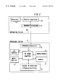
- a vehicle navigation system shown in FIG. 1 comprises a guidance system 10 installed in the vehicle.
- the guidance system 10 has an on-board computer 11 , by means of which the other components 12 to 19 of the guidance system 10 are connected to one another and can be controlled.
- An input device 12 in the form, for example, of a keyboard permits the input of the destination point, for example, a street name.
- the specified destination point can be stored in the memory 13 and is thus available to be called up as needed.
- GPS Global Positioning System
- the current location which is continually determinable from the received satellite signals can be stored by the on-board computer 11 in the memory 13 .
- the most favorable determined route, based on the current location and the input destination point is stored in the memory 13 in the form of path points that contain the geographic data.
- the guidance system 10 has a display device 15 equipped with an visual display, such, for example, as a video screen by means of which the route can be displayed, together with the driving instructions, under the partial or complete control of the on-board computer 11 .
- the current vehicle location is thereby displayed highlighted by color, for example.
- a distance determination/comparison device 19 determines the linear distance from the current vehicle location to the next path point of the two path points between which the vehicle is located at a given moment.
- the distance determination/comparison device 19 compares the determined linear distance with a preset minimum value.
- a warning signal can be triggered, specifically, when the determined linear distance exceeds the preset minimum value by a preset threshold value.
- a preset threshold value is provided for each individual section of the route. Thanks to the warning signal, a suitable audible signal for the driver can be produced by the on-board computer 11 and/or suitable driving instructions can be issued via the visual display of the display device 15 .
- the preset minimum value can be replaced by the current determined linear distance when the previous minimum value is greater than this determined linear distance.
- the latter is connected to a communications device 17 , particularly a mobile phone, by means of which a data connection can be established to an off-board navigation system 20 arranged outside the vehicle.
- a communications device 17 particularly a mobile phone
- the off-board navigation system 20 is equipped with a transmitter/receiver 21 for data exchange with the guidance system 10 .
- the navigation system 20 contains a traffic computer 22 , which has access to a digital road map 23 as well as to current traffic information.
- the driver enters a destination point via the keyboard of the input device 12 .
- the destination point is transmitted, together with the current location of the vehicle as determined by means of the receiver 14 , to the traffic computer 22 of the off-board navigation system 20 by means of the communications device 17 .
- the traffic computer 22 Based on the digital road map 23 , the traffic computer 22 then determines a favorable route to the given destination point. This route is transmitted back to the guidance system 10 in the form of path points and stored in the memory 13 under the control of the on-board computer 11 .
- the current vehicle location is determined on the basis of the signals received by the receiver 14 , so that the distance determination/comparison device 19 can ascertain the two directly consecutive path points between which the vehicle is located at the given moment.
- the distance determination/comparison device 19 continually has available the current location of the vehicle as found by means of the receiver 14 . From this, the distance determination/comparison device 19 continually calculates the linear distance (straight line) from the current location to the next path point that the vehicle will pass on its route, and compares this distance to a preset minimum value. If the calculated distance is greater than the minimum value, the preset minimum value is replaced by the calculated distance. Moreover, if the calculated linear distance for this section of the route exceeds the previous minimum value by a preset threshold value, the distance determination/comparison device 19 triggers a warning signal to signal a departure from the preset route.
- the distance determination/comparison device 19 triggers a warning signal to signal a departure from the preset route.
- a warning signal when triggered, to determine a new route to the destination point and guide the vehicle along this route without explicitly informing the driver that a wrong route was taken.
- the threshold value can also be used to adjust the process to the sometimes very complicated course of a given route. This is advantageous, for example, when the distance to the next path point, i.e., the straight-line connection between the current location of the vehicle and the next path point, temporarily increases, due to a curved or looping section, even though the segment still to be travelled to this path point continues to grow shorter.
- the warning signal alerts the on-board computer 11 to emit a suitable signal to the driver.
- the signal can be emitted acoustically, in the form of a warning tone or a voice message, as well as optically on the display device 15 .
- the driver can obtain, especially by means of the visual display, for example, additional information on the deviation from the preset route as well as driving instructions from the guidance system 10 .
- the distance determination/comparison device 19 is embodied as a calculating program, which can be called up by the on-board computer 11 .
- FIG. 2 The embodiment of the present invention shown in FIG. 2 largely agrees with that in FIG. 1 with respect to the basic functions, so that reference can be made to FIG. 1 and only differences therefrom are discussed below.
- a change in direction determination device 18 is provided instead of the distance determination/comparison device 19 shown in FIG. 1 .
- the change in direction determination device 18 continually receives the current location of the vehicle as determined by the receiver 14 . From this, the change in direction determination device 18 , to ascertain a change in direction between path points, continually calculates the current direction of travel, compares the calculated current direction of travel with a previously ascertained direction of travel, and finds the change in direction in the form of the difference between the directions.
- the change in direction is determined from direction values that are found as the average value of directions for preestablished short sections of the route.
- the sections for which direction data is found should have the same length.
- Averaging is done in such a way that the directions of travel at locations directly following one another in a preestablished section of 50 m, for example, are found, and the average value is calculated from these found directions of travel.
- the direction of travel can be determined by the receiver 14 of the satellite navigation system using an internal calculation process.
- the difference between the current direction of travel and the previous direction of travel is preferably found in that the current direction of travel is determined as the average direction of travel in a preestablished first section, one of whose end points is the current vehicle location, while the previous direction of travel is determined as the average direction of travel in a preestablished second section, whereby the first section directly follows the second section.
- the two sections can overlap or be separated from each other by a distance.
- the direction of travel and the change in direction can also be determined in an ongoing (sliding) manner. When the size of the change in direction exceeds a preset maximum value, a departure from the preestablished route is signalled by a suitable warning, as already described in reference to FIG. 1 .
- FIG. 3 The embodiment of the present invention shown in FIG. 3 agrees largely with that shown in FIG. 1, so that again the earlier description is referred to and, for the most part, only the differences therefrom are discussed below.
- the path point data stored in the memory 13 to define the route comprise not only the geographic coordinates of the locations to be passed, but also, at least for path points in the area of intersections or junctions where a change in direction is to occur, a target turn angle.
- the target turn angle is either a relative angle which is the change in direction of the vehicle at the given intersection or junction, or an absolute angle which is the direction of travel of the vehicle directly after the particular intersection or junction.
- a change in direction determination device 16 as well as a direction of travel determination device 16 a and a comparison device 16 b are provided instead of the distance determination/comparison device 19 shown in FIG. 1 .
- the direction of travel is determined by the direction of travel determination device 16 for path points to which an absolute angle is assigned as the target turn angle.
- the direction of travel can be determined by the receiver 14 of the satellite navigation system using internal calculation processes.
- the determination of the change in direction for path points to which a relative angle is assigned is carried out by the change in direction determination device 16 a .
- the direction of travel determination device 16 and the change in direction determination device 16 a are thereby the essential components of the turn angle determination device.
- a comparison device 16 b is provided, and the respective target values can be called up from the memory 13 . As in FIGS.
- a warning signal to signal a departure from the preestablished route can be triggered by the comparison device 16 b when the direction of travel deviates from the target direction of travel or when the change in direction deviates from the target change in direction by more than a preset tolerance value.
- the destination point is entered via the keyboard of the input device 12 .
- the destination point together with the current location of the vehicle as determined by means of the receiver 14 , is transmitted by the communications device 17 to the traffic computer 22 of the off-board navigation system 20 .
- the traffic computer 22 Based on the digital road map 23 , the traffic computer 22 then determines a favorable route to the preestablished destination point. This route is transmitted back to the guidance system 10 in the form of path points.
- Path points that lie in the area of intersections or junctions where a change in direction is planned i.e., path points that are also turn points of the route, are assigned, as a target turn angle, either a target change in direction (relative angle) or a target direction of travel (absolute angle).
- the path points, along with the target turn angle (target change in direction, target direction of travel), are stored in the memory 13 under the control of the on-board computer 11 .
- the receiver 14 continuously determines the current location and the current direction of travel of the vehicle; it is also possible to provide additional direction sensors for determining direction of travel.
- the average direction of travel of the vehicle is thus determined in that the current directions of travel are found at a predeterminable number of locations (e.g., 50) that follow one another directly in the direction of travel, and the average value is calculated from these directions.
- a predeterminable number of locations e.g., 50
- a short section can be predetermined, and the average value of the respective directions of travel at each vehicle location in this section can be found.
- the direction of travel determination device 16 ascertains the average direction following the path points to which an absolute target turn angle is assigned.
- the change in direction determination device 16 a ascertains the change in direction by finding the difference between the average directions of travel of the vehicle before and after the path point in question.
- the ascertained direction of travel or change in direction is compared with the corresponding target value in the comparison device 16 b .
- the relative turn angle can be checked initially in the interchange area; then, at a predetermined distance after the interchange (i.e., the path point),the direction of travel of the vehicle can be compared to the target direction of travel. This makes it possible, for example, to unambiguously recognize turn angles of 270° at a looping turn.
- the direction of travel and the change in direction can also be determined in continuous (sliding) fashion, and can then be compared with the assigned target value stored in the memory only when a given path point is reached.
- a distance rule can be established, which specifies the distance from the path point at which the average direction of travel should be ascertained. This is especially advisable when the determination of the vehicle location has a non-negligible inaccuracy, as is the case, for example, in a GPS navigation system, due to the consciously built-in distortion of the transmitted signals.
Abstract
Description
Claims (12)
Applications Claiming Priority (7)
| Application Number | Priority Date | Filing Date | Title |
|---|---|---|---|
| DE1995144157 DE19544157C2 (en) | 1995-11-14 | 1995-11-14 | Method and route guidance unit for safe route guidance of a vehicle |
| DE19544157 | 1995-11-14 | ||
| DE1995144381 DE19544381C2 (en) | 1995-11-15 | 1995-11-15 | Method and route guidance unit for safe route guidance of a vehicle |
| DE19544381 | 1995-11-15 | ||
| DE1995144382 DE19544382C2 (en) | 1995-11-15 | 1995-11-15 | Method and route guidance unit for safe route guidance of a vehicle |
| DE19544382 | 1995-11-15 | ||
| PCT/DE1996/002225 WO1997018544A2 (en) | 1995-11-14 | 1996-11-14 | Process and guidance system for ensuring reliable guidance of a vehicle |
Publications (1)
| Publication Number | Publication Date |
|---|---|
| US6211798B1 true US6211798B1 (en) | 2001-04-03 |
Family
ID=27215697
Family Applications (1)
| Application Number | Title | Priority Date | Filing Date |
|---|---|---|---|
| US09/068,728 Expired - Lifetime US6211798B1 (en) | 1995-11-14 | 1996-11-14 | Process and guidance system for ensuring reliable guidance of a vehicle |
Country Status (6)
| Country | Link |
|---|---|
| US (1) | US6211798B1 (en) |
| EP (1) | EP0861482B1 (en) |
| AT (1) | ATE204666T1 (en) |
| DE (1) | DE59607547D1 (en) |
| ES (1) | ES2159779T3 (en) |
| WO (1) | WO1997018544A2 (en) |
Cited By (24)
| Publication number | Priority date | Publication date | Assignee | Title |
|---|---|---|---|---|
| US6529141B1 (en) * | 2000-07-14 | 2003-03-04 | Globe Ranger Corporation | System and method for transmitting a triggered alarm |
| US6691028B2 (en) | 2002-06-07 | 2004-02-10 | Motorola, Inc. | Server-based navigation system and method of operating same |
| EP1488399A2 (en) * | 2002-03-15 | 2004-12-22 | Intellisist, LLC | Vehicle navigation system and method |
| US6892133B2 (en) | 2001-02-26 | 2005-05-10 | Alk Technologies, Inc. | Thin-client navigation and route guidance system |
| FR2862796A1 (en) * | 2004-02-10 | 2005-05-27 | France Telecom | Subjects e.g. person, geographic location monitoring method, involves receiving message comprising geographic coordinates from user for calculating real values of parameters representing displacement of user |
| US6980129B2 (en) * | 2000-07-06 | 2005-12-27 | Robert Bosch Gmbh | Method for determining and outputting travel instructions |
| US20060047414A1 (en) * | 2004-09-02 | 2006-03-02 | Matsushita Electric Industrial Co., Ltd. | Probe-car system using beacon and apparatus therefore |
| US20060142940A1 (en) * | 2004-12-27 | 2006-06-29 | Lg Electronics Inc. | Method for determining deviation of a mobile object in a navigation system from a travel route |
| US20070197897A1 (en) * | 2006-01-13 | 2007-08-23 | Siemens Aktiengesellschaft | Method for displaying a hollow space in an object under investigation |
| US20080079383A1 (en) * | 2006-09-28 | 2008-04-03 | Kabushiki Kaisha Toshiba | Method of controlling movement of robot, mobile robot, and computer program product |
| US20080201071A1 (en) * | 2001-03-29 | 2008-08-21 | Gilad Odinak | Vehicle navigation system and method |
| US20090045927A1 (en) * | 2007-08-15 | 2009-02-19 | Qualcomm Incorporated | System for alerting remote vehicle operator of unsafe transportation network conditions |
| US20100292918A1 (en) * | 2009-05-18 | 2010-11-18 | Foxconn Communication Technology Corp. | Vehicle navigation system and navigation method thereof |
| US20110093189A1 (en) * | 2001-03-29 | 2011-04-21 | Wi-Gui, Llc | System and method for reducing the amount of repetitive data sent by a server to a client for vehicle navigation |
| US20120029805A1 (en) * | 2010-07-30 | 2012-02-02 | Ford Global Technologies, Llc | Vehicle Navigation System and Method |
| US20130013192A1 (en) * | 2008-01-07 | 2013-01-10 | Hakan Yakali | Navigation Device and Method Providing a Logging Function |
| US20130046559A1 (en) * | 2011-08-19 | 2013-02-21 | Hartford Fire Insurance Company | System and method for computing and scoring the complexity of a vehicle trip using geo-spatial information |
| US8428866B1 (en) * | 2010-07-12 | 2013-04-23 | Google Inc. | System and method of providing turn-by-turn directions to non-specific destinations |
| US9075136B1 (en) | 1998-03-04 | 2015-07-07 | Gtj Ventures, Llc | Vehicle operator and/or occupant information apparatus and method |
| US20170069200A1 (en) * | 2014-03-03 | 2017-03-09 | Zenrin Co., Ltd. | Method of collecting probe information, computer-readable recording media and travel time calculation apparatus |
| JP2017146097A (en) * | 2016-02-15 | 2017-08-24 | アルパイン株式会社 | Electronic device, deviation determination system, and deviation determination program |
| US20190129419A1 (en) * | 2017-10-31 | 2019-05-02 | Chunghsin Lee | Automatic Following System and Method |
| US20220269281A1 (en) * | 2021-02-23 | 2022-08-25 | Ran Cheng | Method and system for generating a topological graph map |
| US11549820B2 (en) * | 2016-09-30 | 2023-01-10 | Beijing Baidu Netcom Science And Technology Co., Ltd. | Method and apparatus for generating navigation route and storage medium |
Families Citing this family (3)
| Publication number | Priority date | Publication date | Assignee | Title |
|---|---|---|---|---|
| DE19722186A1 (en) * | 1997-05-27 | 1998-12-03 | Bayerische Motoren Werke Ag | Method for recognizing the time for actuating direction signal lamps (FRSL) in vehicles |
| DE10014806C2 (en) * | 2000-03-27 | 2003-11-27 | Tegaron Telematics Gmbh | Procedure for off-board navigation of a vehicle |
| CN110779539B (en) * | 2019-10-23 | 2021-07-06 | 招商华软信息有限公司 | Driving path correction method, device, equipment and storage medium |
Citations (5)
| Publication number | Priority date | Publication date | Assignee | Title |
|---|---|---|---|---|
| US4774671A (en) * | 1985-03-14 | 1988-09-27 | Nissan Motor Company Limited | Navigation system for automotive vehicle including feature of updating vehicle position at every intersection along preset course |
| US4893246A (en) * | 1986-12-15 | 1990-01-09 | Honda Giken Kogyo Kabushiki Kaisha | Apparatus for displaying travel path |
| US5043902A (en) * | 1987-12-28 | 1991-08-27 | Aisin Aw Co., Ltd. | Vehicular navigation apparatus |
| US5243528A (en) * | 1990-09-12 | 1993-09-07 | Motorola, Inc. | Land vehicle navigation apparatus with visual display |
| US5523765A (en) * | 1993-06-10 | 1996-06-04 | Alpine Electronics, Inc. | Method and apparatus for detecting vehicle location for a vehicle navigation system |
Family Cites Families (2)
| Publication number | Priority date | Publication date | Assignee | Title |
|---|---|---|---|---|
| US5025261A (en) * | 1989-01-18 | 1991-06-18 | Sharp Kabushiki Kaisha | Mobile object navigation system |
| DE4300927C2 (en) * | 1993-01-15 | 2000-08-10 | Andree Kang | Computerized route guidance system for land vehicles |
-
1996
- 1996-11-14 DE DE59607547T patent/DE59607547D1/en not_active Expired - Lifetime
- 1996-11-14 US US09/068,728 patent/US6211798B1/en not_active Expired - Lifetime
- 1996-11-14 ES ES96945998T patent/ES2159779T3/en not_active Expired - Lifetime
- 1996-11-14 EP EP96945998A patent/EP0861482B1/en not_active Expired - Lifetime
- 1996-11-14 WO PCT/DE1996/002225 patent/WO1997018544A2/en active IP Right Grant
- 1996-11-14 AT AT96945998T patent/ATE204666T1/en not_active IP Right Cessation
Patent Citations (5)
| Publication number | Priority date | Publication date | Assignee | Title |
|---|---|---|---|---|
| US4774671A (en) * | 1985-03-14 | 1988-09-27 | Nissan Motor Company Limited | Navigation system for automotive vehicle including feature of updating vehicle position at every intersection along preset course |
| US4893246A (en) * | 1986-12-15 | 1990-01-09 | Honda Giken Kogyo Kabushiki Kaisha | Apparatus for displaying travel path |
| US5043902A (en) * | 1987-12-28 | 1991-08-27 | Aisin Aw Co., Ltd. | Vehicular navigation apparatus |
| US5243528A (en) * | 1990-09-12 | 1993-09-07 | Motorola, Inc. | Land vehicle navigation apparatus with visual display |
| US5523765A (en) * | 1993-06-10 | 1996-06-04 | Alpine Electronics, Inc. | Method and apparatus for detecting vehicle location for a vehicle navigation system |
Cited By (39)
| Publication number | Priority date | Publication date | Assignee | Title |
|---|---|---|---|---|
| US9075136B1 (en) | 1998-03-04 | 2015-07-07 | Gtj Ventures, Llc | Vehicle operator and/or occupant information apparatus and method |
| US6980129B2 (en) * | 2000-07-06 | 2005-12-27 | Robert Bosch Gmbh | Method for determining and outputting travel instructions |
| US6529141B1 (en) * | 2000-07-14 | 2003-03-04 | Globe Ranger Corporation | System and method for transmitting a triggered alarm |
| US6892133B2 (en) | 2001-02-26 | 2005-05-10 | Alk Technologies, Inc. | Thin-client navigation and route guidance system |
| US20110093189A1 (en) * | 2001-03-29 | 2011-04-21 | Wi-Gui, Llc | System and method for reducing the amount of repetitive data sent by a server to a client for vehicle navigation |
| US8121781B2 (en) | 2001-03-29 | 2012-02-21 | Wi-Gui, Llp | System and method for reducing the amount of repetitive data sent by a server to a client for vehicle navigation |
| US20080201071A1 (en) * | 2001-03-29 | 2008-08-21 | Gilad Odinak | Vehicle navigation system and method |
| USRE46109E1 (en) | 2001-03-29 | 2016-08-16 | Lg Electronics Inc. | Vehicle navigation system and method |
| EP1488399A2 (en) * | 2002-03-15 | 2004-12-22 | Intellisist, LLC | Vehicle navigation system and method |
| EP1488399B1 (en) * | 2002-03-15 | 2013-12-18 | Promind Co., Ltd. | Vehicle navigation system and method |
| US6691028B2 (en) | 2002-06-07 | 2004-02-10 | Motorola, Inc. | Server-based navigation system and method of operating same |
| FR2862796A1 (en) * | 2004-02-10 | 2005-05-27 | France Telecom | Subjects e.g. person, geographic location monitoring method, involves receiving message comprising geographic coordinates from user for calculating real values of parameters representing displacement of user |
| US20060047414A1 (en) * | 2004-09-02 | 2006-03-02 | Matsushita Electric Industrial Co., Ltd. | Probe-car system using beacon and apparatus therefore |
| US7653484B2 (en) * | 2004-12-27 | 2010-01-26 | Lg Electronics Inc. | Method for determining deviation of a mobile object in a navigation system from a travel route |
| US20060142940A1 (en) * | 2004-12-27 | 2006-06-29 | Lg Electronics Inc. | Method for determining deviation of a mobile object in a navigation system from a travel route |
| US20070197897A1 (en) * | 2006-01-13 | 2007-08-23 | Siemens Aktiengesellschaft | Method for displaying a hollow space in an object under investigation |
| US8521252B2 (en) * | 2006-01-13 | 2013-08-27 | Siemens Aktiengesellschaft | Method for displaying a hollow space in an object under investigation |
| US7554282B2 (en) * | 2006-09-28 | 2009-06-30 | Kabushiki Kaisha Toshiba | Method of controlling movement of robot, mobile robot, and computer program product |
| US20080079383A1 (en) * | 2006-09-28 | 2008-04-03 | Kabushiki Kaisha Toshiba | Method of controlling movement of robot, mobile robot, and computer program product |
| US20090045927A1 (en) * | 2007-08-15 | 2009-02-19 | Qualcomm Incorporated | System for alerting remote vehicle operator of unsafe transportation network conditions |
| US20130013192A1 (en) * | 2008-01-07 | 2013-01-10 | Hakan Yakali | Navigation Device and Method Providing a Logging Function |
| US9329048B2 (en) * | 2008-01-07 | 2016-05-03 | Tomtom International B.V. | Navigation device and method providing a logging function |
| US20100292918A1 (en) * | 2009-05-18 | 2010-11-18 | Foxconn Communication Technology Corp. | Vehicle navigation system and navigation method thereof |
| US8725409B2 (en) * | 2009-05-18 | 2014-05-13 | Fih (Hong Kong) Limited | Vehicle navigation system and navigation method thereof |
| US8428866B1 (en) * | 2010-07-12 | 2013-04-23 | Google Inc. | System and method of providing turn-by-turn directions to non-specific destinations |
| US8352186B2 (en) * | 2010-07-30 | 2013-01-08 | Ford Global Technologies, Llc | Vehicle navigation system and method |
| US8355871B2 (en) | 2010-07-30 | 2013-01-15 | Ford Global Technologies, Llc | Vehicle navigation system and method |
| US20120029805A1 (en) * | 2010-07-30 | 2012-02-02 | Ford Global Technologies, Llc | Vehicle Navigation System and Method |
| US8799035B2 (en) | 2011-08-19 | 2014-08-05 | Hartford Fire Insurance Company | System and method for determining an insurance premium based on complexity of a vehicle trip |
| US20130046559A1 (en) * | 2011-08-19 | 2013-02-21 | Hartford Fire Insurance Company | System and method for computing and scoring the complexity of a vehicle trip using geo-spatial information |
| US8538785B2 (en) * | 2011-08-19 | 2013-09-17 | Hartford Fire Insurance Company | System and method for computing and scoring the complexity of a vehicle trip using geo-spatial information |
| US9928736B2 (en) * | 2014-03-03 | 2018-03-27 | Zenrin Co., Ltd. | Method of collecting probe information, computer-readable recording media and travel time calculation apparatus |
| US20170069200A1 (en) * | 2014-03-03 | 2017-03-09 | Zenrin Co., Ltd. | Method of collecting probe information, computer-readable recording media and travel time calculation apparatus |
| JP2017146097A (en) * | 2016-02-15 | 2017-08-24 | アルパイン株式会社 | Electronic device, deviation determination system, and deviation determination program |
| US11549820B2 (en) * | 2016-09-30 | 2023-01-10 | Beijing Baidu Netcom Science And Technology Co., Ltd. | Method and apparatus for generating navigation route and storage medium |
| US20190129419A1 (en) * | 2017-10-31 | 2019-05-02 | Chunghsin Lee | Automatic Following System and Method |
| CN109725636A (en) * | 2017-10-31 | 2019-05-07 | 沛升动能有限公司 | Automatic driving vehicle follows the system and method for objects in front, tracking system automatically |
| US10948912B2 (en) * | 2017-10-31 | 2021-03-16 | Passion Mobility Ltd. | Automatic following system and method |
| US20220269281A1 (en) * | 2021-02-23 | 2022-08-25 | Ran Cheng | Method and system for generating a topological graph map |
Also Published As
| Publication number | Publication date |
|---|---|
| ATE204666T1 (en) | 2001-09-15 |
| EP0861482A2 (en) | 1998-09-02 |
| EP0861482B1 (en) | 2001-08-22 |
| ES2159779T3 (en) | 2001-10-16 |
| DE59607547D1 (en) | 2001-09-27 |
| WO1997018544A3 (en) | 1997-07-17 |
| WO1997018544A2 (en) | 1997-05-22 |
Similar Documents
| Publication | Publication Date | Title |
|---|---|---|
| US6211798B1 (en) | Process and guidance system for ensuring reliable guidance of a vehicle | |
| KR0179076B1 (en) | On-board route display receiving information from external device | |
| EP1696209B1 (en) | Guiding a drive path of a moving object in a navigation system | |
| JP2799324B2 (en) | Route determination method and route guidance module for route guidance system | |
| US5504482A (en) | Automobile navigation guidance, control and safety system | |
| JP4497748B2 (en) | Navigation device, server device for navigation system, destination estimation processing program, and recording medium recording destination estimation processing program | |
| EP0702209B1 (en) | Vehicular navigation system | |
| US7406381B2 (en) | Navigation system, vehicle navigation apparatus, and method for obtaining navigation information | |
| US7653484B2 (en) | Method for determining deviation of a mobile object in a navigation system from a travel route | |
| JP3555466B2 (en) | Navigation center device and navigation device | |
| US7447573B2 (en) | Driving control device for a vehicle | |
| JPH02760B2 (en) | ||
| US6760662B2 (en) | Route guiding method for in-vehicle navigation device | |
| EP1724555A2 (en) | Method for displaying information in a navigation system | |
| US6952180B2 (en) | Method and apparatus for determination of position | |
| JPH09178502A (en) | Navigation system | |
| EP1079355B1 (en) | Navigation apparatus and information generating apparatus | |
| EP3441723A1 (en) | Navigation system and method for exchange mutual location information using messenger | |
| US6708111B2 (en) | Route entry guiding device and method in a navigation system using a portable terminal | |
| US6324468B1 (en) | Process for transmitting route information which concerns a route of a vehicle in a road network between a traffic information center and a terminal in a vehicle, traffic information center and terminal | |
| EP1223408B1 (en) | Guide display method in on-vehicle navigator | |
| US20040210387A1 (en) | Method for operating a navigation system for a vehicle | |
| US6236935B1 (en) | Navigation-assistance method and device for a vehicle driver | |
| JP2004340689A (en) | Course guiding device | |
| JP4654968B2 (en) | Navigation device |
Legal Events
| Date | Code | Title | Description |
|---|---|---|---|
| AS | Assignment |
Owner name: MANNESMANN AG, GERMANY Free format text: ASSIGNMENT OF ASSIGNORS INTEREST;ASSIGNORS:ALBRECHT, UWE;GARTHWAITE, PAUL;WAIZMANN, GERD;REEL/FRAME:009411/0627;SIGNING DATES FROM 19980408 TO 19980416 |
|
| STCF | Information on status: patent grant |
Free format text: PATENTED CASE |
|
| AS | Assignment |
Owner name: VODAFONE AG, GERMANY Free format text: CHANGE OF NAME;ASSIGNOR:MANENSMANN AG;REEL/FRAME:014186/0475 Effective date: 20010920 Owner name: VODAFONE HOLDING GMBH, GERMANY Free format text: CHANGE OF NAME;ASSIGNOR:VODAFONE AG;REEL/FRAME:014186/0558 Effective date: 20021119 |
|
| AS | Assignment |
Owner name: ATX EUROPE GMBH, GERMANY Free format text: CHANGE OF NAME;ASSIGNOR:VODAFONE HOLDING GMBH;REEL/FRAME:014186/0823 Effective date: 20021119 |
|
| FPAY | Fee payment |
Year of fee payment: 4 |
|
| REMI | Maintenance fee reminder mailed | ||
| FPAY | Fee payment |
Year of fee payment: 8 |
|
| SULP | Surcharge for late payment |
Year of fee payment: 7 |
|
| AS | Assignment |
Owner name: ATX GROUP, INC., TEXAS Free format text: ASSIGNMENT OF ASSIGNORS INTEREST;ASSIGNOR:ATX EUROPE GMBH;REEL/FRAME:026352/0162 Effective date: 20110331 |
|
| AS | Assignment |
Owner name: BANK OF AMERICA, N.A., MASSACHUSETTS Free format text: SECURITY AGREEMENT;ASSIGNOR:ATX GROUP, INC.;REEL/FRAME:026416/0043 Effective date: 20110603 |
|
| AS | Assignment |
Owner name: AGERO CONNECTED SERVICES, INC., TEXAS Free format text: CHANGE OF NAME;ASSIGNOR:ATX GROUP, INC.;REEL/FRAME:027486/0145 Effective date: 20111108 |
|
| FPAY | Fee payment |
Year of fee payment: 12 |
|
| AS | Assignment |
Owner name: AGERO CONNECTED SERVICES, INC., TEXAS Free format text: RELEASE AGREEMENT;ASSIGNOR:BANK OF AMERICA, N.A.;REEL/FRAME:032386/0052 Effective date: 20131104 Owner name: SIRIUS XM CONNECTED VEHICLE SERVICES INC., TEXAS Free format text: CHANGE OF NAME;ASSIGNOR:AGERO CONNECTED SERVICES, INC.;REEL/FRAME:032385/0906 Effective date: 20131104 |
|
| AS | Assignment |
Owner name: U.S. BANK NATIONAL ASSOCIATION, NEW YORK Free format text: PATENT SECURITY AGREEMENT;ASSIGNORS:SIRIUS XM RADIO INC.;SIRIUS XM CONNECTED VEHICLE SERVICES INC.;REEL/FRAME:032660/0603 Effective date: 20140410 |
|
| AS | Assignment |
Owner name: JPMORGAN CHASE BANK, N.A., DELAWARE Free format text: PATENT SECURITY AGREEMENT;ASSIGNOR:SIRIUS XM CONNECTED VEHICLE SERVICES INC.;REEL/FRAME:032835/0907 Effective date: 20140506 |
|
| AS | Assignment |
Owner name: SIRIUS XM CONNECTED VEHICLE SERVICES INC., NEW YORK Free format text: RELEASE BY SECURED PARTY;ASSIGNOR:U.S. BANK NATIONAL ASSOCIATION;REEL/FRAME:043747/0091 Effective date: 20170901 Owner name: SIRIUS XM CONNECTED VEHICLE SERVICES INC., NEW YOR Free format text: RELEASE BY SECURED PARTY;ASSIGNOR:U.S. BANK NATIONAL ASSOCIATION;REEL/FRAME:043747/0091 Effective date: 20170901 Owner name: SIRIUS XM RADIO INC., NEW YORK Free format text: RELEASE BY SECURED PARTY;ASSIGNOR:U.S. BANK NATIONAL ASSOCIATION;REEL/FRAME:043747/0091 Effective date: 20170901 |