US20030191578A1 - Method and system for providing reminders about points of interests while traveling - Google Patents
Method and system for providing reminders about points of interests while traveling Download PDFInfo
- Publication number
- US20030191578A1 US20030191578A1 US10/402,610 US40261003A US2003191578A1 US 20030191578 A1 US20030191578 A1 US 20030191578A1 US 40261003 A US40261003 A US 40261003A US 2003191578 A1 US2003191578 A1 US 2003191578A1
- Authority
- US
- United States
- Prior art keywords
- user
- location
- navigation system
- proximity
- category
- Prior art date
- Legal status (The legal status is an assumption and is not a legal conclusion. Google has not performed a legal analysis and makes no representation as to the accuracy of the status listed.)
- Granted
Links
Images


Classifications
-
- G—PHYSICS
- G01—MEASURING; TESTING
- G01C—MEASURING DISTANCES, LEVELS OR BEARINGS; SURVEYING; NAVIGATION; GYROSCOPIC INSTRUMENTS; PHOTOGRAMMETRY OR VIDEOGRAMMETRY
- G01C21/00—Navigation; Navigational instruments not provided for in groups G01C1/00 - G01C19/00
- G01C21/26—Navigation; Navigational instruments not provided for in groups G01C1/00 - G01C19/00 specially adapted for navigation in a road network
- G01C21/34—Route searching; Route guidance
- G01C21/36—Input/output arrangements for on-board computers
- G01C21/3679—Retrieval, searching and output of POI information, e.g. hotels, restaurants, shops, filling stations, parking facilities
- G01C21/3682—Retrieval, searching and output of POI information, e.g. hotels, restaurants, shops, filling stations, parking facilities output of POI information on a road map
-
- G—PHYSICS
- G01—MEASURING; TESTING
- G01C—MEASURING DISTANCES, LEVELS OR BEARINGS; SURVEYING; NAVIGATION; GYROSCOPIC INSTRUMENTS; PHOTOGRAMMETRY OR VIDEOGRAMMETRY
- G01C21/00—Navigation; Navigational instruments not provided for in groups G01C1/00 - G01C19/00
- G01C21/26—Navigation; Navigational instruments not provided for in groups G01C1/00 - G01C19/00 specially adapted for navigation in a road network
- G01C21/34—Route searching; Route guidance
- G01C21/36—Input/output arrangements for on-board computers
- G01C21/3605—Destination input or retrieval
- G01C21/3614—Destination input or retrieval through interaction with a road map, e.g. selecting a POI icon on a road map
Definitions
- the present invention relates to navigation systems and more particularly the present invention relates to a feature in a navigation system that facilitates making stops at points of interest of a specified type while traveling.
- Navigation systems are available that provide end users (such as drivers and passengers of the vehicles in which the in-vehicle navigation systems are installed) with various navigation-related functions and features. For example, some navigation systems are able to determine an optimum route to travel by roads between locations in a geographic region. Using input from the end user, and optionally from equipment that can determine one's physical location (such as a GPS system), a navigation system can examine various routes between two locations to determine an optimum route to travel from a starting location to a destination location in a geographic region. The navigation system may then provide the end user with information about the optimum route in the form of guidance that identifies the driving maneuvers required to be taken by the end user to travel from the starting location to the destination location.
- end users such as drivers and passengers of the vehicles in which the in-vehicle navigation systems are installed
- some navigation systems are able to determine an optimum route to travel by roads between locations in a geographic region. Using input from the end user, and optionally from equipment that can determine one's physical location (such as
- the guidance may take the form of visual and/or audio instructions that are provided along the way as the end user is traveling the route.
- Some navigation systems are able to show detailed maps on computer displays outlining routes to destinations, the types of maneuvers to be taken at various locations along the routes, locations of certain types of features, and so on.
- the geographic data may be in the form of one or more databases that include data that represent physical features in a geographic region.
- the geographic database may include data representing the roads and intersections in a geographic region and also may include information relating to the represented roads and intersections in the geographic region, such as turn restrictions at intersections, speed limits along the roads, street names of the various roads, address ranges along the roads, and so on.
- a person can use a navigation system to identify points of interest of a particular type (e.g., restaurants) that are close to the person's location and receive guidance for traveling to any of the identified points of interest.
- This type of usage represents one kind of travel that persons commonly make but there are various other kinds of travel. For example, some kinds of locations do not have to be visited immediately.
- a person might want to stop at a post office (or other type of point of interest) sometime within the next several days when it is convenient to do so but would rather not make a special trip.
- the person would prefer to make the stop at the post office while in route to another destination if the stop can be made without taking a significant additional amount of time.
- the present invention comprises a method, system, and/or programming for providing a feature in a navigation system that allows a user to specify a type of point of interest and then receive a reminder when the user is in proximity to a point of interest of the specified type while traveling in a geographic region.
- the reminder is provided while the user is traveling to a location other than a point of interest of the specified type.
- This feature allows a user to make stops at points of interest of a particular type at the convenience of the user and when the user is close to the point of interest of a particular type, thereby minimizing travel time.
- FIG. 1 is a block diagram showing components of an exemplary navigation system used in conjunction with a first embodiment of a feature that provides reminders about points of interest of a specified type while traveling.
- FIG. 2 is a block diagram showing portions of the navigation application programming in FIG. 1.
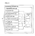
- FIG. 3 is a block diagram illustrating some of the types of data contained in the geographic database shown in FIGS. 1 and 2.
- FIG. 4 is a block diagram illustrating some of the components of the point of interest data shown in FIG. 3.
- FIG. 5 is a block diagram illustrating some of the components of the routing data shown in FIG. 3.
- FIG. 6 shows the navigation system display screen of FIG. 1 with a menu for selecting the point of interest reminder feature.
- FIG. 7 shows the display screen of the navigation system with a menu for selecting a category of points of interest for which reminders are desired.
- FIG. 8 shows the navigation system display screen of FIG. 1 with a menu for configuring the threshold of the point of interest reminder feature.
- FIG. 9 is a flowchart showing steps performed by the point of interest reminder routine in FIG. 2.
- FIG. 10 shows the display screen of the navigation system with a presentation of data provided by the point of interest reminder routine according to the process of FIG. 9.
- FIG. 11 shows the display screen of the navigation system with a message provided by the point of interest reminder routine of FIG. 9 prompting the user to select a point of interest to which route guidance is to be provided.
- a “navigation system” is understood to mean a navigation system used in a vehicle (i.e., an in-vehicle navigation system).
- a “navigation system” is also understood to mean any software application installed on a computer platform that provides navigation-related features and uses geographic data, including applications that are installed on personal computers, networks, portable electronic devices, and so on.
- FIG. 1 there is a block diagram of a navigation system 110 .
- the navigation system 110 is installed in a vehicle 111 , such as a car, bus, or truck, although in alternative embodiments, the navigation system 110 may be located outside of a vehicle or may be implemented in various other platforms or environments, as described below.
- the navigation system 110 is a combination of hardware and software components.
- the navigation system 110 includes a processor 112 , a drive 114 connected to the processor 112 , and a non-volatile memory storage device 116 for storing programming 118 and possibly other information.
- the processor 112 may be of any type used in navigation systems.
- the navigation system 110 may also include a positioning system 124 .
- the positioning system 24 may utilize GPS-type technology, a dead reckoning-type system, or combinations of these or other systems, all of which are known in the art.
- the positioning system 124 may include suitable sensing devices 125 that measure the traveling distance, speed, direction, and so on, of the vehicle.
- the positioning system 124 may also include appropriate technology to obtain a GPS signal in a manner which is known in the art.
- the positioning system 124 provides an output to the processor 112 .
- the output from the positioning system 124 is used by the software 118 that is run on the processor 112 to determine the location, direction, speed, etc., of the navigation system 110 .
- the navigation system 110 also includes a user interface 131 .
- the user interface 131 includes appropriate equipment that allows the end user to input information into the navigation system.
- This input information may include a request to use the navigation features of the navigation system.
- the input information may include a request for a route to a desired destination.
- the input information may also include other kinds of information.
- the equipment used to input information into the navigation system may include an input panel 130 , such as a keypad, a keyboard, buttons, switches, etc., or a microphone 128 , etc., as well as appropriate software, such as voice recognition programming.
- the user interface 131 also includes suitable equipment that provides information back to the end user. This equipment may include a display 132 , speakers 133 , or other means.
- the programming 118 is loaded from the non-volatile memory 116 into a RAM 134 associated with the processor 112 in order to operate the navigation system.
- the programming 118 includes navigation-related application software 119 that provides for the navigating functions and features of the navigation system 110 .
- the navigation-related application software 119 uses geographic data 140 , possibly in conjunction with the output from the positioning system 124 , to provide various navigation features and functions.
- the navigation-related application software 119 may include separate component applications (also referred to as programs, subprograms, routines, or tools) that provide these various navigation-related features and functions.
- FIG. 2 shows some of the component applications for one embodiment of the navigation-related software 119 included in the navigation system 110 of FIG. 1.
- These component applications may include a geo-coding application 141 (used for destination selection), a route calculation application 142 , a route guidance 144 application (wherein detailed directions are provided for reaching a desired destination), a map display application 146 , and a vehicle positioning application 148 (wherein a vehicle position is related to the geographic data 140 ).
- the applications 119 may include a point of interest reminder selection routine 340 and a point of interest reminder presentation routine 400 (which are explained in more detail below).
- the navigation-related software applications 119 may also include other component applications 152 .
- the component applications of the programming 118 may work together through defined programming interfaces.
- the navigation-related application software 119 may access the geographic data 140 directly, or alternatively, the navigation application software 119 accesses the geographic data 140 through an interface layer 154 and operating system 156 .
- the interface layer 154 and operating system 156 may be part of the programming 118 or may be provided separately.
- the programming 118 may also include manager application software 155 .
- the manager application software 155 provide interfaces to the hardware in the user interface 131 and the positioning system 124 .
- the manager application software 155 may also coordinate requests for data from the navigation-related applications 119 .
- the separate applications of the programming 118 are written in the C programming language although in alternative embodiments other programming languages may be used, such as C++, Java, Visual Basic, and so on.
- the geographic data 140 is organized into one or more databases 162 and stored on a storage medium 164 .
- the storage medium 164 is installed in the drive 114 so that the geographic data 140 can be read and used by the navigation system.
- the storage medium 164 may be removable and replaceable so that a storage medium with an appropriate database 162 for the geographic region in which the vehicle is traveling can be used.
- the storage medium 164 may be replaceable so that geographic data 140 on it can be updated easily.
- the geographic data are provided by Navigation Technologies Corporation of Rosemont, Ill. However it is understood that the inventive concepts disclosed herein are not restricted to any particular source of data.
- the storage medium 164 is a CD-ROM disk.
- the storage medium 164 may be a PCMCIA card in which case the drive 114 would be replaced with a PCMCIA slot.
- Various other storage media may be used, including fixed or hard disks, DVD disks or other currently available storage media, as well as storage media that may be developed in the future.
- the storage medium 164 and the geographic data 140 do not have to be physically provided at the location of the navigation system.
- the storage medium 164 upon which some or all of the geographic data 140 are stored, may be located remotely from the rest of the navigation system and portions of the geographic data provided via a communications link, as needed.
- the map database 162 contains information about the roadway network in the geographic region.
- the map database 162 includes node data and segment data. These data represent components of the physical road network. Node data represent physical locations in the geographic region (such as roadway intersections and other positions) and segment data represent portions of roadways between the physical locations represented by nodes. (The terms “nodes” and “segments” represent only one terminology for describing these physical geographic features and other terminology for describing these features is intended to be encompassed within the scope of these concepts.)
- a navigation system uses geographic data in certain known and expected ways to perform known functions
- the geographic data can be organized, structured, and/or arranged in ways that facilitate their use by the navigation system.
- Some of the ways that geographic data 140 can be can be organized, structured, or arranged in a geographic database are described in U.S. Pat. Nos. 5,968,109, 5,974,419, and 5,953,722, the entire disclosures of which are incorporated by reference herein.
- FIG. 3 illustrates an organization of the geographic database 162 .
- the organization shown in FIG. 3 represents one way that geographic data 140 can be organized in a database. Various other arrangements are possible and can be used.
- the geographic database 162 is shown to be comprised of separate subsets 164 of data. These subsets 164 include routing data 166 , cartographic data 167 (for map display), maneuver data 168 (for route guidance), point-of-interest data 169 (for identifying specific points of interest, such as hotels, restaurants, museums, stadiums, airports, etc.), name data 170 (identifying the names of roads, places and other features), places 171 (e.g., cities, states, counties), postal codes 172 and other kinds of data 173 .
- the geographic database 162 may be defined with different data types or with fewer or more data types.
- Each subset 164 of geographic data 160 includes the data and associated attributes required to perform a particular navigation function but excludes data and attributes which are not needed to perform the function. There is some overlap of data between each of these subsets, with the result that some information may be included in more than one subset.
- a data entity representing a road segment in the routing data 166 and a data entity representing the same road segment in the cartographic data 167 may include attributes identifying the nodes located at the ends of the road segment.
- indexes 176 are included as part of the geographic database 162 .
- the indexes 176 provide cross references, search trees, and/or other data finding techniques.
- the indexes 176 can be located external of any of the data types 164 or the indexes 176 may be located within any of the types 164 of data. In this embodiment of the geographic database 164 , both internal and external indexes are used.
- FIG. 4 shows some of the kinds of information included in the point of interest data 169 .
- the point of interest data 169 includes a plurality of data records 269 each of which includes data about a separate point of interest located in the coverage area of the geographic database 162 .
- a point of interest record 269 includes a point of interest ID 269 ( 1 ), name data 269 ( 2 ), street data 269 ( 3 ), location data 269 ( 4 ), facility type data 269 ( 5 ), administrative zone data 269 ( 6 ), postal code data 269 ( 7 ), phone number data 269 ( 8 ), chain ID data 269 ( 9 ), and possibly other data 269 ( 10 ).
- the point of interest ID 269 ( 1 ) includes a number or code by which the point of interest record 269 can be identified in the database 162 .
- the name data 269 ( 2 ) contains the name of the represented point of interest.
- the street data 269 ( 3 ) contains the street address of the represented point of interest.
- the location data 269 ( 4 ) contains an identification of a road segment data record in the routing data 166 that represents the road segment along which the represented point of interest is located or alternatively, the location data 269 ( 4 ) may contain the geographic coordinates of the represented point of interest.
- the facility type data 269 ( 5 ) contains data indicating the type of facility or business the represented point of interest is, e.g., restaurant, post office, antique store, city hall, convention center, automobile repair shop, gas station, ATM, sports facility, hotel, and so on. Within some of these types, the point of interest may include further classification data, e.g., type of restaurant (Chinese, Italian, etc.).
- the administrative zone data 269 ( 6 ) contains the name of the municipality (e.g., city or town) and state of the represented point of interest.
- the postal code data 269 ( 7 ) contains the appropriate postal code information (e.g., zip code in the U.S.) of the represented point of interest.
- the phone number data 269 ( 8 ) contains the phone number of the represented point of interest. If the represented point of interest is part of a business chain, the point of interest record contains data in a chain ID data 269 ( 9 ) that identifies the business chain.
- FIG. 5 shows some of the kinds of information included in the routing data ( 166 in FIG. 3).
- the routing data 166 includes a plurality of road segment data records 258 each of which includes data about a separate road segment located in the coverage area of the geographic database 162 .
- a road segment record 258 includes a segment ID 258 ( 1 ) by which the data record can be identified in the geographic database 162 .
- the road segment data record 258 may also include data 258 ( 2 ) that indicates the restrictions, if any, on the direction of vehicular travel permitted on the represented road segment.
- the road segment data record 258 includes data 258 ( 3 ) that indicates a speed limit or speed category (i.e., the maximum permitted vehicular speed of travel on the represented road segment).
- the road segment data record 258 may also include data 258 ( 4 ) indicating whether the represented road segment is part of a controlled access road (such as an expressway), a ramp to a controlled access road, a bridge, a tunnel, a toll road, a ferry, and so on.
- the road segment data record 258 may also include data 258 ( 5 ) indicating a travel time which indicates an estimated amount of time to travel along the road segment.
- the travel time data 258 ( 5 ) may be expressed in seconds or may be expressed in arbitrary units.
- the travel time data 258 ( 5 ) may include separate travel times for each direction of travel along the segment.
- the travel time data 258 ( 5 ) may include separate travel times for different times of day, day of week, etc.
- the road segment data record 258 also includes data 258 ( 7 ) providing the geographic coordinates (e.g., the latitude and longitude) of the endpoints of the road segment.
- these data 258 ( 7 ) contain references to the node data records 260 ( 1 ) and 260 ( 2 ) that represent the nodes corresponding to the endpoints of the represented road segment.
- the road segment record 258 may also include or be associated with other data 258 ( 6 ) that refer to various other attributes of the represented road segment.
- the road segment data record may include data identifying what turn restrictions exist at each of the nodes which correspond to intersections at the ends of the road portion represented by the road segment, the name or names by which the represented road segment is known, the street address ranges along the represented road segment, and so on.
- the various attributes associated with a road segment may be included in a single road segment record, or preferably are included in more than one type of road segment record which are cross-referenced to each other.
- Embodiments of the disclosed navigation system feature provide reminders (audible, visual, or both) to a navigation system user when the user is close to a point of interest (e.g., type of business, facility, location, etc.) of a type that had been previously identified by the user. These reminders are provided while the user is traveling in a geographic area. These reminders are provided regardless of whether the navigation system is being used to receive driving instructions to travel to a destination. Thus, the user may be following his/her own route and not receiving driving instructions from the navigation system. Alternatively, the user may be receiving driving instructions to travel to a destination other than a point of interest of the previously identified type. Reminders may be accompanied with an option to provide route guidance to one of the points of interest of the specified type that are identified as being close to the user's current location.
- a point of interest e.g., type of business, facility, location, etc.
- FIG. 6 shows a menu 320 on the display 132 of the navigation system 110 .
- the menu 320 presents a plurality of available features 327 .
- the user is prompted by a message 326 to choose one of the available features 327 .
- One of the features is highlighted with an outlining box 330 .
- the user can manually press a toggle 332 on the keypad 130 of the user interface 131 to move the outlining box 330 up or down in order to change the feature highlighted with the outlining box 330 .
- the outlining box 330 is on the feature that the user wants to choose, the user presses another key to select the highlighted feature. For example, the user may press a “SELECT” key 336 .
- the feature labeled “ADD PROXIMITY REMINDER” is highlighted with the outlining box 330 and the user can select this item by pressing the “SELECT” key 336 .
- the point of interest selection routine ( 340 in FIG. 2) is called.
- the point of interest selection routine 340 is included among the applications 119 in the navigation system 110 .
- FIG. 7 shows a menu 360 on the display 132 .
- the 360 menu includes a list of a plurality 362 of different categories (or types) of points of interest.
- the list of point of interest categories is generated by the point of interest selection routine 340 using the facility type data ( 269 ( 5 ) in FIG. 4) from the point of interest data 169 from the geographic database 162 .
- the point of interest selection routine 340 also provides a message 364 prompting the user to select a category (or type) of point of interest.
- One of the categories is highlighted with an outlining box 366 .
- the “POST OFFICES” category is highlighted with the outlining box 366 .
- the user can manually press the toggle 332 of the user interface 131 to move the outlining box 366 up or down.
- the user operates the controls on the user interface 131 (e.g., pressing the “SELECT” key 336 ) to select one of the types of points of interest for which proximity reminders are desired.
- the point of interest selection routine 340 causes data indicating this point of interest type to be stored in a user data portion 372 of the non-volatile storage 116 of the navigation system 110 .
- These data 370 remain in the non-volatile storage 116 even when the navigation system and vehicle are turned off so that the data 370 are available whenever the navigation system is being used.
- the user may select the points of interest for which reminders are provided by chain instead of by point of interest type. If the user chooses to have point of interest reminders provided by chain, reminders will be provided whenever the user is in proximity to a location of an establishment of that particular chain. For example, the user may want to be reminded when he/she is close to a McDonald's restaurant.
- the chain ID data 269 ( 9 ) in FIG. 4 are used by the point of interest selection routine 340 in a similar manner as the facility type data were used, as described above.
- the proximity reminder feature is configured with a threshold parameter.
- the threshold parameter may be a threshold distance.
- the navigation system identifies all the points of interest of the specified type to the user that are within the threshold distance of the present location of the user while the user is traveling in the geographic area.
- the threshold parameter is a threshold travel time.
- the navigation system identifies all the points of interest of the specified type to the user that can be reached within the threshold travel time from the present location of the user while the user is traveling in a region taking into account the travel times of roads located around the user.
- a threshold parameter may combine distance and travel time. According to this alternative, a point of interest which is close (as the crow flies), would be eliminated if the amount of time required to reach it exceeded a time of travel threshold.
- a dynamic threshold parameter can be used.
- a dynamic threshold parameter takes into account current factors when determining whether any points of interest of the specified type are in proximity to the user's current position.
- a dynamic threshold may take into account the type of road that the vehicle is traveling on, the vehicle's current speed, the time of day, the day of week, the hours of operation of the point of interest, and so on.
- the dynamic threshold may also take into account the duration of time for which the reminder has been set.
- the threshold parameters may be user-configurable.
- FIG. 8 shows a menu 380 on the display 132 that can be used for configuring the threshold parameter and/or threshold travel time. If the user does not specify a threshold parameter, a default threshold parameter may be used.
- a user can specify different thresholds for different types of points of interest. For example, a 1 mile distance threshold can be set for post offices and a 5 mile distance threshold can be set for gas stations.
- data 374 indicating the threshold are stored in the user data portion 372 of the non-volatile storage 116 of the navigation system 110 . These data 374 remain in the non-volatile storage 116 even when the navigation system and vehicle are turned off.
- the point of interest (POI) proximity reminder routine 400 ( 400 in FIG. 2) is run.
- a flowchart showing a general process of the POI proximity reminder routine 400 is shown in FIG. 9.
- the POI proximity reminder routine 400 runs in the background and is configured so as not to interfere with other higher priority processes that are being performed by the navigation system 110 .
- a first step 410 of the POI proximity reminder routine 400 obtains the POI category type selection data 370 and the threshold data 374 , if any, from the user data 372 . Then, the routine obtains data indicating the current vehicle position (Step 420 ). Data indicating the current vehicle position are obtained from the vehicle positioning application 148 (shown in FIGS. 2 and 9). Using the POI category type data 370 , the threshold data 374 , and the vehicle position data, the process searches the point of interest data 169 in the geographic database 162 to identify all the points of interest of the selected type that are within the specified threshold of the current vehicle position (Step 430 ). (Note that if a travel time threshold or other type of threshold other than a distance threshold is used, the process may call other routines to identify the points of interest of the selected type that are within the applicable threshold from the current vehicle position.)
- Step 436 If there are no points of interest of the selected type within the threshold from the current vehicle position, the process loops back to the step of obtaining an updated vehicle position (Step 436 ). However, if there are points of interest of the selected type within the threshold from the current vehicle position, the process 400 displays information to the user identifying the points of interest and requests the user whether route guidance to any of the identified points of interest is desired (Step 440 ).
- FIG. 10 shows an image 500 provided by the POI proximity reminder routine 400 on the display 132 of the navigation system 110 for these purposes.
- the image 500 contains a map 504 of the roads in the area around the vehicle.
- An image 506 of the vehicle is superimposed on the map image 504 .
- images 520 indicating the locations of points of interest of the specified type relative to the road network and the vehicle.
- data 530 indicating data about the respective point of interest.
- the data 530 may indicate the distance to the point of interest from the current position of the vehicle and/or the travel time to the point of interest from the current position of the vehicle.
- the image 500 also includes a message 540 indicating to the user that one or more points of interest of the specified type are in proximity to the current position of the vehicle.
- the message 540 may also include an indication of the type of point of interest category being displayed. In the example shown in FIG. 10, the message 540 states “REMINDER! POST OFFICES IN PROXIMITY.”
- the image 500 also includes a message 550 prompting the user to indicate whether he/she would like route guidance to any of the indicated points of interest. If the user wants route guidance to one of the indicated points of interest, he/she can so indicate by pressing the “SELECT” key 336 . Otherwise, the user can indicate that he/she does not want route guidance to any of the indicated points of interest by pressing the “CANCEL” key or by waiting a few seconds without responding which is taken by the POI reminder routine 400 as a negative response.
- the POI proximity reminder routine 400 obtains an indication from the user whether reminders about additional points of interest of the specified type should be provided during the current driving session if any such additional points of interest of the specified type are encountered (Step 460 ). If the user indicates that no more reminders are desired, the POI proximity reminder routine 400 stops operating for the remainder of the driving session or until it is restarted (Step 470 ). On the other hand, if the user indicates that reminders about additional points of interest are desired, the process loops back to the step (Step 420 ) to obtain a new vehicle position.
- FIG. 11 shows an image 600 provided by the POI proximity reminder routine 400 on the display 132 of the navigation system 110 for this purpose.
- the image 600 contains the map 504 , the image 506 of the vehicle, and images 520 of the points of interest.
- the image 600 also includes a message 616 indicating to the user that one point of interest of the specified type is to be selected.
- the message 616 states “CHOOSE ONE POST OFFICE FOR ROUTE GUIDANCE.”
- Associated with an image of one of the point of interest locations is a highlighting box 620 .
- the highlighting box 620 can be moved from one image 520 of a point of interest to another by appropriate manipulation of the user interface controls (e.g., toggle 332 ).
- the image 600 also includes a message 650 indicating to the user to press the “SELECT” key 336 to obtain route guidance for the point of interest associated with the highlighting box 620 .
- the POI proximity reminder routine 400 calls the route calculation application 142 and the route guidance application 144 to provide the user with guidance for traveling to the selected point of interest. After the user has been guided to the selected point of interest, the POI proximity reminder routine 400 obtains input from the user indicating whether the user would like to continue obtaining reminders about this type of point of interest. If the user indicates positively, the POI proximity reminder routine 400 loops back to the step of obtaining a new vehicle position. Otherwise, if the user indicates negatively, the POI proximity reminder routine 400 stops.
- the POI proximity reminder routine 400 obtains input from the user indicating whether the user would like to resume traveling to the destination. If the user responds affirmatively, the POI proximity reminder routine 400 calls the route calculation application 142 and the route guidance application 144 to calculate a route from the location of the POI to the destination and provide the user with guidance for following the route.
- the POI proximity reminder routine 400 can be used to obtain reminder about more than one type of point of interest. If reminders are desired about more than one type of point of interest, the different types of points of interest can be displayed together or alternatively, the different types of points of interest can be displayed separately, e.g., one after the other.
- the POI proximity reminder feature is described as being included in a navigation system.
- a navigation system can be a vehicle navigation system or any software application installed on a computer platform that provides navigation-related features and that uses geographic data.
- the POI proximity reminder feature can be provided on platforms including personal computers, networks (including wireless networks and the Internet), personal digital assistants, PalmPilot®-type devices, cellular telephones (including any type of portable telephone that uses any type of technology, such as PCS/GSM, and so on), pagers and other portable electronic devices.
- the equipment that determines the location of the device that provides the POI proximity reminder feature can be located locally with the device or remotely. As described above, the equipment that determines the location of the device that provides the POI proximity reminder feature can include GPS equipment located locally with the device. Alternatively, the location of the device that provides the POI proximity reminder feature can be determined remotely using technologies like those used for determining locations of cellular phones in an area. There are various available technologies that provide this feature. Some of the companies that provide this type of technology include ArrayComm, Inc., Harris Corporation, Corsair Communications, Lockheed Martin Corporation, CELLTRAX, Inc., TruePosition, Inc., Cell-Loc Inc., KSI Inc., and U.S. Wireless Corporation. Some of these technologies can be used to locate a cellular phone user who dials an emergency number, e.g., “911.” Any such technology that is presently available or that becomes available in the future may be suitable.
- a proximity reminder feature in a navigation system can incorporate real-time information.
- the proximity reminder feature can provide a user with reminders about aspects of places that change relatively quickly.
- the proximity reminder feature in a navigation system can be used to provide a user with a reminder when the user is close to a gas station at which the gasoline price is less than a certain user-specified amount.
- the navigation system receives real-time data from a data provider. The navigation system may receive this data via a wireless communications link.
- the real-time data relate to points of interest or other places in a geographic area.
- the points of interest or other places to which the real-time data relate may already be represented in the database used by the navigation system or alternatively, the real-time data may relate to new points of interest or places that are not already represented in the database used by the navigation system.
- the proximity reminder feature uses the real-time data in conjunction with the data indicating the locations of places to which the real-time data relate to determine when the user is close to a location to which the real-time data relate. For example, if the real-time information indicates the price of gasoline at gas stations in an area, the proximity reminder feature filters the data representing gas station points of interest to determine those gas stations offering gasoline below the user's specified threshold price and then provides a reminder to the user when the user is in proximity to one of the gas stations.
- Real-time information can be used by the proximity reminder feature in a navigation system for various other changeable aspects of points of interest. For example, real-time information can be used by the proximity reminder feature in a navigation system to remind the user when he/she is close to a hotel room less than a specified price. Real-time information can also be used by the proximity reminder feature in a navigation system to remind the user when he/she is close to a cinema at which a user-specified movie is showing. Real-time information can also be used by the proximity reminder feature in a navigation system to remind the user when he/she is close to a business at which a sale is underway.
Abstract
Description
- The present invention relates to navigation systems and more particularly the present invention relates to a feature in a navigation system that facilitates making stops at points of interest of a specified type while traveling.
- Navigation systems are available that provide end users (such as drivers and passengers of the vehicles in which the in-vehicle navigation systems are installed) with various navigation-related functions and features. For example, some navigation systems are able to determine an optimum route to travel by roads between locations in a geographic region. Using input from the end user, and optionally from equipment that can determine one's physical location (such as a GPS system), a navigation system can examine various routes between two locations to determine an optimum route to travel from a starting location to a destination location in a geographic region. The navigation system may then provide the end user with information about the optimum route in the form of guidance that identifies the driving maneuvers required to be taken by the end user to travel from the starting location to the destination location. The guidance may take the form of visual and/or audio instructions that are provided along the way as the end user is traveling the route. Some navigation systems are able to show detailed maps on computer displays outlining routes to destinations, the types of maneuvers to be taken at various locations along the routes, locations of certain types of features, and so on.
- In order to provide these and other navigating functions, navigation systems use geographic data. The geographic data may be in the form of one or more databases that include data that represent physical features in a geographic region. The geographic database may include data representing the roads and intersections in a geographic region and also may include information relating to the represented roads and intersections in the geographic region, such as turn restrictions at intersections, speed limits along the roads, street names of the various roads, address ranges along the roads, and so on.
- Although navigation systems provide many important features, there continues to be room for new features or other improvements. One area in which there is room for improvement relates to making travel more convenient. A person can use a navigation system to identify points of interest of a particular type (e.g., restaurants) that are close to the person's location and receive guidance for traveling to any of the identified points of interest. This type of usage represents one kind of travel that persons commonly make but there are various other kinds of travel. For example, some kinds of locations do not have to be visited immediately. As an example, a person might want to stop at a post office (or other type of point of interest) sometime within the next several days when it is convenient to do so but would rather not make a special trip. Ideally, the person would prefer to make the stop at the post office while in route to another destination if the stop can be made without taking a significant additional amount of time.
- Accordingly, there is a need for a feature in a navigation system that provides guidance about making stops at locations at the convenience of the user.
- To address these and other objectives, the present invention comprises a method, system, and/or programming for providing a feature in a navigation system that allows a user to specify a type of point of interest and then receive a reminder when the user is in proximity to a point of interest of the specified type while traveling in a geographic region. The reminder is provided while the user is traveling to a location other than a point of interest of the specified type. This feature allows a user to make stops at points of interest of a particular type at the convenience of the user and when the user is close to the point of interest of a particular type, thereby minimizing travel time.
- FIG. 1 is a block diagram showing components of an exemplary navigation system used in conjunction with a first embodiment of a feature that provides reminders about points of interest of a specified type while traveling.
- FIG. 2 is a block diagram showing portions of the navigation application programming in FIG. 1.
- FIG. 3 is a block diagram illustrating some of the types of data contained in the geographic database shown in FIGS. 1 and 2.
- FIG. 4 is a block diagram illustrating some of the components of the point of interest data shown in FIG. 3.
- FIG. 5 is a block diagram illustrating some of the components of the routing data shown in FIG. 3.
- FIG. 6 shows the navigation system display screen of FIG. 1 with a menu for selecting the point of interest reminder feature.
- FIG. 7 shows the display screen of the navigation system with a menu for selecting a category of points of interest for which reminders are desired.
- FIG. 8 shows the navigation system display screen of FIG. 1 with a menu for configuring the threshold of the point of interest reminder feature.
- FIG. 9 is a flowchart showing steps performed by the point of interest reminder routine in FIG. 2.
- FIG. 10 shows the display screen of the navigation system with a presentation of data provided by the point of interest reminder routine according to the process of FIG. 9.
- FIG. 11 shows the display screen of the navigation system with a message provided by the point of interest reminder routine of FIG. 9 prompting the user to select a point of interest to which route guidance is to be provided.
- I. Navigation System—Overview
- For purposes of this disclosure, a “navigation system” is understood to mean a navigation system used in a vehicle (i.e., an in-vehicle navigation system). A “navigation system” is also understood to mean any software application installed on a computer platform that provides navigation-related features and uses geographic data, including applications that are installed on personal computers, networks, portable electronic devices, and so on.
- Referring to FIG. 1, there is a block diagram of a
navigation system 110. Thenavigation system 110 is installed in avehicle 111, such as a car, bus, or truck, although in alternative embodiments, thenavigation system 110 may be located outside of a vehicle or may be implemented in various other platforms or environments, as described below. Thenavigation system 110 is a combination of hardware and software components. In one embodiment, thenavigation system 110 includes aprocessor 112, adrive 114 connected to theprocessor 112, and a non-volatile memory storage device 116 for storingprogramming 118 and possibly other information. Theprocessor 112 may be of any type used in navigation systems. - The
navigation system 110 may also include apositioning system 124. Thepositioning system 24 may utilize GPS-type technology, a dead reckoning-type system, or combinations of these or other systems, all of which are known in the art. Thepositioning system 124 may includesuitable sensing devices 125 that measure the traveling distance, speed, direction, and so on, of the vehicle. Thepositioning system 124 may also include appropriate technology to obtain a GPS signal in a manner which is known in the art. Thepositioning system 124 provides an output to theprocessor 112. The output from thepositioning system 124 is used by thesoftware 118 that is run on theprocessor 112 to determine the location, direction, speed, etc., of thenavigation system 110. - The
navigation system 110 also includes auser interface 131. Theuser interface 131 includes appropriate equipment that allows the end user to input information into the navigation system. This input information may include a request to use the navigation features of the navigation system. For example, the input information may include a request for a route to a desired destination. The input information may also include other kinds of information. The equipment used to input information into the navigation system may include aninput panel 130, such as a keypad, a keyboard, buttons, switches, etc., or amicrophone 128, etc., as well as appropriate software, such as voice recognition programming. Theuser interface 131 also includes suitable equipment that provides information back to the end user. This equipment may include adisplay 132,speakers 133, or other means. - The
programming 118 is loaded from the non-volatile memory 116 into aRAM 134 associated with theprocessor 112 in order to operate the navigation system. Referring to FIG. 2, theprogramming 118 includes navigation-related application software 119 that provides for the navigating functions and features of thenavigation system 110. The navigation-related application software 119 usesgeographic data 140, possibly in conjunction with the output from thepositioning system 124, to provide various navigation features and functions. The navigation-related application software 119 may include separate component applications (also referred to as programs, subprograms, routines, or tools) that provide these various navigation-related features and functions. - FIG. 2 shows some of the component applications for one embodiment of the navigation-related software 119 included in the
navigation system 110 of FIG. 1. These component applications may include a geo-coding application 141 (used for destination selection), aroute calculation application 142, aroute guidance 144 application (wherein detailed directions are provided for reaching a desired destination), amap display application 146, and a vehicle positioning application 148 (wherein a vehicle position is related to the geographic data 140). The applications 119 may include a point of interest reminder selection routine 340 and a point of interest reminder presentation routine 400 (which are explained in more detail below). The navigation-related software applications 119 may also includeother component applications 152. - The component applications of the
programming 118 may work together through defined programming interfaces. The navigation-related application software 119 may access thegeographic data 140 directly, or alternatively, the navigation application software 119 accesses thegeographic data 140 through aninterface layer 154 andoperating system 156. Theinterface layer 154 andoperating system 156 may be part of theprogramming 118 or may be provided separately. - In addition to the navigation-related applications 119, the
programming 118 may also includemanager application software 155. Themanager application software 155 provide interfaces to the hardware in theuser interface 131 and thepositioning system 124. Themanager application software 155 may also coordinate requests for data from the navigation-related applications 119. - In one embodiment, the separate applications of the
programming 118 are written in the C programming language although in alternative embodiments other programming languages may be used, such as C++, Java, Visual Basic, and so on. - II. The Geographic Map Database
- A. Overview.
- Referring to FIG. 2, the
geographic data 140 is organized into one ormore databases 162 and stored on astorage medium 164. Thestorage medium 164 is installed in thedrive 114 so that thegeographic data 140 can be read and used by the navigation system. Thestorage medium 164 may be removable and replaceable so that a storage medium with anappropriate database 162 for the geographic region in which the vehicle is traveling can be used. In addition, thestorage medium 164 may be replaceable so thatgeographic data 140 on it can be updated easily. - In one embodiment, the geographic data are provided by Navigation Technologies Corporation of Rosemont, Ill. However it is understood that the inventive concepts disclosed herein are not restricted to any particular source of data.
- In one embodiment, the
storage medium 164 is a CD-ROM disk. In an alternative embodiment, thestorage medium 164 may be a PCMCIA card in which case thedrive 114 would be replaced with a PCMCIA slot. Various other storage media may be used, including fixed or hard disks, DVD disks or other currently available storage media, as well as storage media that may be developed in the future. Thestorage medium 164 and thegeographic data 140 do not have to be physically provided at the location of the navigation system. In alternative embodiments, thestorage medium 164, upon which some or all of thegeographic data 140 are stored, may be located remotely from the rest of the navigation system and portions of the geographic data provided via a communications link, as needed. - The
map database 162 contains information about the roadway network in the geographic region. In one embodiment, themap database 162 includes node data and segment data. These data represent components of the physical road network. Node data represent physical locations in the geographic region (such as roadway intersections and other positions) and segment data represent portions of roadways between the physical locations represented by nodes. (The terms “nodes” and “segments” represent only one terminology for describing these physical geographic features and other terminology for describing these features is intended to be encompassed within the scope of these concepts.) - Because a navigation system uses geographic data in certain known and expected ways to perform known functions, the geographic data can be organized, structured, and/or arranged in ways that facilitate their use by the navigation system. Some of the ways that
geographic data 140 can be can be organized, structured, or arranged in a geographic database are described in U.S. Pat. Nos. 5,968,109, 5,974,419, and 5,953,722, the entire disclosures of which are incorporated by reference herein. - FIG. 3 illustrates an organization of the
geographic database 162. The organization shown in FIG. 3 represents one way thatgeographic data 140 can be organized in a database. Various other arrangements are possible and can be used. In FIG. 3, thegeographic database 162 is shown to be comprised ofseparate subsets 164 of data. Thesesubsets 164 includerouting data 166, cartographic data 167 (for map display), maneuver data 168 (for route guidance), point-of-interest data 169 (for identifying specific points of interest, such as hotels, restaurants, museums, stadiums, airports, etc.), name data 170 (identifying the names of roads, places and other features), places 171 (e.g., cities, states, counties),postal codes 172 and other kinds ofdata 173. Thegeographic database 162 may be defined with different data types or with fewer or more data types. - Each
subset 164 of geographic data 160 includes the data and associated attributes required to perform a particular navigation function but excludes data and attributes which are not needed to perform the function. There is some overlap of data between each of these subsets, with the result that some information may be included in more than one subset. For example, a data entity representing a road segment in therouting data 166 and a data entity representing the same road segment in thecartographic data 167 may include attributes identifying the nodes located at the ends of the road segment. Although this duplication may result in a larger overall data storage requirement, each of the navigation functions (i.e., the applications 119 in FIG. 2) benefits from the resultant efficiency of handling smaller amounts of data. - Although the organization of the
geographic data 140 into different types provides for efficient use of the data by the different navigation functions, it is necessary to provide that the different functions that use these different data types work together. To permit thesetypes 164 of data to work together,indexes 176 are included as part of thegeographic database 162. Theindexes 176 provide cross references, search trees, and/or other data finding techniques. Theindexes 176 can be located external of any of thedata types 164 or theindexes 176 may be located within any of thetypes 164 of data. In this embodiment of thegeographic database 164, both internal and external indexes are used. - FIG. 4 shows some of the kinds of information included in the point of
interest data 169. The point ofinterest data 169 includes a plurality ofdata records 269 each of which includes data about a separate point of interest located in the coverage area of thegeographic database 162. A point ofinterest record 269 includes a point of interest ID 269(1), name data 269(2), street data 269(3), location data 269(4), facility type data 269(5), administrative zone data 269(6), postal code data 269(7), phone number data 269(8), chain ID data 269(9), and possibly other data 269(10). The point of interest ID 269(1) includes a number or code by which the point ofinterest record 269 can be identified in thedatabase 162. The name data 269(2) contains the name of the represented point of interest. The street data 269(3) contains the street address of the represented point of interest. The location data 269(4) contains an identification of a road segment data record in therouting data 166 that represents the road segment along which the represented point of interest is located or alternatively, the location data 269(4) may contain the geographic coordinates of the represented point of interest. The facility type data 269(5) contains data indicating the type of facility or business the represented point of interest is, e.g., restaurant, post office, antique store, city hall, convention center, automobile repair shop, gas station, ATM, sports facility, hotel, and so on. Within some of these types, the point of interest may include further classification data, e.g., type of restaurant (Chinese, Italian, etc.). The administrative zone data 269(6) contains the name of the municipality (e.g., city or town) and state of the represented point of interest. The postal code data 269(7) contains the appropriate postal code information (e.g., zip code in the U.S.) of the represented point of interest. The phone number data 269(8) contains the phone number of the represented point of interest. If the represented point of interest is part of a business chain, the point of interest record contains data in a chain ID data 269(9) that identifies the business chain. - FIG. 5 shows some of the kinds of information included in the routing data ( 166 in FIG. 3). The
routing data 166 includes a plurality of roadsegment data records 258 each of which includes data about a separate road segment located in the coverage area of thegeographic database 162. Aroad segment record 258 includes a segment ID 258(1) by which the data record can be identified in thegeographic database 162. The roadsegment data record 258 may also include data 258(2) that indicates the restrictions, if any, on the direction of vehicular travel permitted on the represented road segment. The roadsegment data record 258 includes data 258(3) that indicates a speed limit or speed category (i.e., the maximum permitted vehicular speed of travel on the represented road segment). The roadsegment data record 258 may also include data 258(4) indicating whether the represented road segment is part of a controlled access road (such as an expressway), a ramp to a controlled access road, a bridge, a tunnel, a toll road, a ferry, and so on. The roadsegment data record 258 may also include data 258(5) indicating a travel time which indicates an estimated amount of time to travel along the road segment. The travel time data 258(5) may be expressed in seconds or may be expressed in arbitrary units. The travel time data 258(5) may include separate travel times for each direction of travel along the segment. The travel time data 258(5) may include separate travel times for different times of day, day of week, etc. - The road
segment data record 258 also includes data 258(7) providing the geographic coordinates (e.g., the latitude and longitude) of the endpoints of the road segment. In one embodiment, these data 258(7) contain references to the node data records 260(1) and 260(2) that represent the nodes corresponding to the endpoints of the represented road segment. - The
road segment record 258 may also include or be associated with other data 258(6) that refer to various other attributes of the represented road segment. For example, the road segment data record may include data identifying what turn restrictions exist at each of the nodes which correspond to intersections at the ends of the road portion represented by the road segment, the name or names by which the represented road segment is known, the street address ranges along the represented road segment, and so on. The various attributes associated with a road segment may be included in a single road segment record, or preferably are included in more than one type of road segment record which are cross-referenced to each other. - III. Proximity Convenience Reminders
- A. Overview.
- Embodiments of the disclosed navigation system feature provide reminders (audible, visual, or both) to a navigation system user when the user is close to a point of interest (e.g., type of business, facility, location, etc.) of a type that had been previously identified by the user. These reminders are provided while the user is traveling in a geographic area. These reminders are provided regardless of whether the navigation system is being used to receive driving instructions to travel to a destination. Thus, the user may be following his/her own route and not receiving driving instructions from the navigation system. Alternatively, the user may be receiving driving instructions to travel to a destination other than a point of interest of the previously identified type. Reminders may be accompanied with an option to provide route guidance to one of the points of interest of the specified type that are identified as being close to the user's current location.
- B. Selecting Point of Interest Types for Reminders.
- FIG. 6 shows a
menu 320 on thedisplay 132 of thenavigation system 110. Themenu 320 presents a plurality ofavailable features 327. The user is prompted by amessage 326 to choose one of the available features 327. One of the features is highlighted with anoutlining box 330. The user can manually press atoggle 332 on thekeypad 130 of theuser interface 131 to move theoutlining box 330 up or down in order to change the feature highlighted with theoutlining box 330. When theoutlining box 330 is on the feature that the user wants to choose, the user presses another key to select the highlighted feature. For example, the user may press a “SELECT” key 336. In FIG. 6, the feature labeled “ADD PROXIMITY REMINDER” is highlighted with theoutlining box 330 and the user can select this item by pressing the “SELECT” key 336. (Other features that are available on thismenu 320 include calculating a new route to a new destination and calculating alternative routes to the existing destination.) When the user selects the feature “ADD PROXIMITY REMINDER”, the point of interest selection routine (340 in FIG. 2) is called. The point of interest selection routine 340 is included among the applications 119 in thenavigation system 110. - FIG. 7 shows a
menu 360 on thedisplay 132. The 360 menu includes a list of aplurality 362 of different categories (or types) of points of interest. The list of point of interest categories is generated by the point of interest selection routine 340 using the facility type data (269(5) in FIG. 4) from the point ofinterest data 169 from thegeographic database 162. The point of interest selection routine 340 also provides amessage 364 prompting the user to select a category (or type) of point of interest. One of the categories is highlighted with anoutlining box 366. In the embodiment of FIG. 7, the “POST OFFICES” category is highlighted with theoutlining box 366. If the user wishes to change the category highlighted with theoutlining box 366, the user can manually press thetoggle 332 of theuser interface 131 to move theoutlining box 366 up or down. In response to themessage 364, the user operates the controls on the user interface 131 (e.g., pressing the “SELECT” key 336) to select one of the types of points of interest for which proximity reminders are desired. Referring to FIG. 1, when a point of interest category type is selected, the point of interest selection routine 340 causes data indicating this point of interest type to be stored in a user data portion 372 of the non-volatile storage 116 of thenavigation system 110. Thesedata 370 remain in the non-volatile storage 116 even when the navigation system and vehicle are turned off so that thedata 370 are available whenever the navigation system is being used. - According to one embodiment, the user may select the points of interest for which reminders are provided by chain instead of by point of interest type. If the user chooses to have point of interest reminders provided by chain, reminders will be provided whenever the user is in proximity to a location of an establishment of that particular chain. For example, the user may want to be reminded when he/she is close to a McDonald's restaurant. When point of interest reminders are selected by chain, the chain ID data ( 269(9) in FIG. 4) are used by the point of interest selection routine 340 in a similar manner as the facility type data were used, as described above.
- C. Selecting Thresholds.
- According to some embodiments, the proximity reminder feature is configured with a threshold parameter. The threshold parameter may be a threshold distance. When configured with a threshold distance, the navigation system identifies all the points of interest of the specified type to the user that are within the threshold distance of the present location of the user while the user is traveling in the geographic area.
- According to other embodiments, the threshold parameter is a threshold travel time. When configured with a threshold travel time, the navigation system identifies all the points of interest of the specified type to the user that can be reached within the threshold travel time from the present location of the user while the user is traveling in a region taking into account the travel times of roads located around the user.
- In addition to distance thresholds and travel time thresholds, other types of threshold parameters may be used. For example, a threshold parameter may combine distance and travel time. According to this alternative, a point of interest which is close (as the crow flies), would be eliminated if the amount of time required to reach it exceeded a time of travel threshold.
- In alternative embodiments, a dynamic threshold parameter can be used. A dynamic threshold parameter takes into account current factors when determining whether any points of interest of the specified type are in proximity to the user's current position. For example, a dynamic threshold may take into account the type of road that the vehicle is traveling on, the vehicle's current speed, the time of day, the day of week, the hours of operation of the point of interest, and so on. The dynamic threshold may also take into account the duration of time for which the reminder has been set.
- According to some embodiments, the threshold parameters (e.g., distance and/or travel time) may be user-configurable. FIG. 8 shows a
menu 380 on thedisplay 132 that can be used for configuring the threshold parameter and/or threshold travel time. If the user does not specify a threshold parameter, a default threshold parameter may be used. - According to one embodiment, a user can specify different thresholds for different types of points of interest. For example, a 1 mile distance threshold can be set for post offices and a 5 mile distance threshold can be set for gas stations.
- Referring to FIG. 1, when a threshold of any type is selected,
data 374 indicating the threshold are stored in the user data portion 372 of the non-volatile storage 116 of thenavigation system 110. Thesedata 374 remain in the non-volatile storage 116 even when the navigation system and vehicle are turned off. - D. Operation.
- As stated above, after the user has selected a point of interest category type (or chain) and, optionally, a threshold,
data data proximity reminder routine 400 is shown in FIG. 9. The POI proximity reminder routine 400 runs in the background and is configured so as not to interfere with other higher priority processes that are being performed by thenavigation system 110. - Referring to FIG. 9, a
first step 410 of the POIproximity reminder routine 400 obtains the POI categorytype selection data 370 and thethreshold data 374, if any, from the user data 372. Then, the routine obtains data indicating the current vehicle position (Step 420). Data indicating the current vehicle position are obtained from the vehicle positioning application 148 (shown in FIGS. 2 and 9). Using the POIcategory type data 370, thethreshold data 374, and the vehicle position data, the process searches the point ofinterest data 169 in thegeographic database 162 to identify all the points of interest of the selected type that are within the specified threshold of the current vehicle position (Step 430). (Note that if a travel time threshold or other type of threshold other than a distance threshold is used, the process may call other routines to identify the points of interest of the selected type that are within the applicable threshold from the current vehicle position.) - If there are no points of interest of the selected type within the threshold from the current vehicle position, the process loops back to the step of obtaining an updated vehicle position (Step 436). However, if there are points of interest of the selected type within the threshold from the current vehicle position, the
process 400 displays information to the user identifying the points of interest and requests the user whether route guidance to any of the identified points of interest is desired (Step 440). FIG. 10 shows animage 500 provided by the POI proximity reminder routine 400 on thedisplay 132 of thenavigation system 110 for these purposes. - In FIG. 10, the
image 500 contains amap 504 of the roads in the area around the vehicle. Animage 506 of the vehicle is superimposed on themap image 504. Also superimposed on themap image 504 areimages 520 indicating the locations of points of interest of the specified type relative to the road network and the vehicle. Associated with each image of the location of the points of interest aredata 530 indicating data about the respective point of interest. For example, thedata 530 may indicate the distance to the point of interest from the current position of the vehicle and/or the travel time to the point of interest from the current position of the vehicle. - The
image 500 also includes amessage 540 indicating to the user that one or more points of interest of the specified type are in proximity to the current position of the vehicle. Themessage 540 may also include an indication of the type of point of interest category being displayed. In the example shown in FIG. 10, themessage 540 states “REMINDER! POST OFFICES IN PROXIMITY.” - In the embodiment of FIG. 10, the
image 500 also includes amessage 550 prompting the user to indicate whether he/she would like route guidance to any of the indicated points of interest. If the user wants route guidance to one of the indicated points of interest, he/she can so indicate by pressing the “SELECT” key 336. Otherwise, the user can indicate that he/she does not want route guidance to any of the indicated points of interest by pressing the “CANCEL” key or by waiting a few seconds without responding which is taken by thePOI reminder routine 400 as a negative response. - Referring again to FIG. 9, if the user does not want to be guided to any of the indicated points of interest, the POI
proximity reminder routine 400 obtains an indication from the user whether reminders about additional points of interest of the specified type should be provided during the current driving session if any such additional points of interest of the specified type are encountered (Step 460). If the user indicates that no more reminders are desired, the POI proximity reminder routine 400 stops operating for the remainder of the driving session or until it is restarted (Step 470). On the other hand, if the user indicates that reminders about additional points of interest are desired, the process loops back to the step (Step 420) to obtain a new vehicle position. - Referring back to
Step 456 in FIG. 9, if the user responds positively to the message (550 in FIG. 10) indicating that he/she wants route guidance to one of the indicated points of interest, the POIproximity selection routine 400 prompts the user to select one of the points of interest to which route guidance will be provided. FIG. 11 shows animage 600 provided by the POI proximity reminder routine 400 on thedisplay 132 of thenavigation system 110 for this purpose. In FIG. 11, theimage 600 contains themap 504, theimage 506 of the vehicle, andimages 520 of the points of interest. - The
image 600 also includes amessage 616 indicating to the user that one point of interest of the specified type is to be selected. In the example shown in FIG. 11, themessage 616 states “CHOOSE ONE POST OFFICE FOR ROUTE GUIDANCE.” Associated with an image of one of the point of interest locations is a highlightingbox 620. The highlightingbox 620 can be moved from oneimage 520 of a point of interest to another by appropriate manipulation of the user interface controls (e.g., toggle 332). In the embodiment of FIG. 11, theimage 600 also includes amessage 650 indicating to the user to press the “SELECT” key 336 to obtain route guidance for the point of interest associated with the highlightingbox 620. - When the highlighting
box 620 is associated with the desired point of interest, the user selects the point of interest by pressing the “SELECT” key 336. When the user has selected one of the points of interest, the POI proximity reminder routine 400 calls theroute calculation application 142 and theroute guidance application 144 to provide the user with guidance for traveling to the selected point of interest. After the user has been guided to the selected point of interest, the POIproximity reminder routine 400 obtains input from the user indicating whether the user would like to continue obtaining reminders about this type of point of interest. If the user indicates positively, the POI proximity reminder routine 400 loops back to the step of obtaining a new vehicle position. Otherwise, if the user indicates negatively, the POI proximity reminder routine 400 stops. In addition, if the user had been receiving guidance for traveling to a destination before receiving the reminder about being in proximity to a POI of a selected type, the POIproximity reminder routine 400 obtains input from the user indicating whether the user would like to resume traveling to the destination. If the user responds affirmatively, the POI proximity reminder routine 400 calls theroute calculation application 142 and theroute guidance application 144 to calculate a route from the location of the POI to the destination and provide the user with guidance for following the route. - If only one point of interest of the specified type is found in proximity to the current vehicle position, the step of having the user choose one point of interest for which route guidance is to be provided can be omitted.
- In alternative embodiments, the POI proximity reminder routine 400 can be used to obtain reminder about more than one type of point of interest. If reminders are desired about more than one type of point of interest, the different types of points of interest can be displayed together or alternatively, the different types of points of interest can be displayed separately, e.g., one after the other.
- E. Alternative Embodiments
- The POI proximity reminder feature is described as being included in a navigation system. A navigation system can be a vehicle navigation system or any software application installed on a computer platform that provides navigation-related features and that uses geographic data. The POI proximity reminder feature can be provided on platforms including personal computers, networks (including wireless networks and the Internet), personal digital assistants, PalmPilot®-type devices, cellular telephones (including any type of portable telephone that uses any type of technology, such as PCS/GSM, and so on), pagers and other portable electronic devices.
- The equipment that determines the location of the device that provides the POI proximity reminder feature can be located locally with the device or remotely. As described above, the equipment that determines the location of the device that provides the POI proximity reminder feature can include GPS equipment located locally with the device. Alternatively, the location of the device that provides the POI proximity reminder feature can be determined remotely using technologies like those used for determining locations of cellular phones in an area. There are various available technologies that provide this feature. Some of the companies that provide this type of technology include ArrayComm, Inc., Harris Corporation, Corsair Communications, Lockheed Martin Corporation, CELLTRAX, Inc., TruePosition, Inc., Cell-Loc Inc., KSI Inc., and U.S. Wireless Corporation. Some of these technologies can be used to locate a cellular phone user who dials an emergency number, e.g., “911.” Any such technology that is presently available or that becomes available in the future may be suitable.
- In another alternative embodiment, a proximity reminder feature in a navigation system can incorporate real-time information. With real-time information, the proximity reminder feature can provide a user with reminders about aspects of places that change relatively quickly. For example, according to this embodiment, the proximity reminder feature in a navigation system can be used to provide a user with a reminder when the user is close to a gas station at which the gasoline price is less than a certain user-specified amount. To incorporate real-time information, the navigation system receives real-time data from a data provider. The navigation system may receive this data via a wireless communications link. The real-time data relate to points of interest or other places in a geographic area. The points of interest or other places to which the real-time data relate may already be represented in the database used by the navigation system or alternatively, the real-time data may relate to new points of interest or places that are not already represented in the database used by the navigation system. The proximity reminder feature uses the real-time data in conjunction with the data indicating the locations of places to which the real-time data relate to determine when the user is close to a location to which the real-time data relate. For example, if the real-time information indicates the price of gasoline at gas stations in an area, the proximity reminder feature filters the data representing gas station points of interest to determine those gas stations offering gasoline below the user's specified threshold price and then provides a reminder to the user when the user is in proximity to one of the gas stations. Real-time information can be used by the proximity reminder feature in a navigation system for various other changeable aspects of points of interest. For example, real-time information can be used by the proximity reminder feature in a navigation system to remind the user when he/she is close to a hotel room less than a specified price. Real-time information can also be used by the proximity reminder feature in a navigation system to remind the user when he/she is close to a cinema at which a user-specified movie is showing. Real-time information can also be used by the proximity reminder feature in a navigation system to remind the user when he/she is close to a business at which a sale is underway.
- It is intended that the foregoing detailed description be regarded as illustrative rather than limiting and that it is understood that the following claims including all equivalents are intended to define the scope of the invention.
Claims (34)
Priority Applications (1)
| Application Number | Priority Date | Filing Date | Title |
|---|---|---|---|
| US10/402,610 US6850837B2 (en) | 2000-03-14 | 2003-03-28 | Method and system for providing reminders about points of interests while traveling |
Applications Claiming Priority (2)
| Application Number | Priority Date | Filing Date | Title |
|---|---|---|---|
| US09/525,701 US6587782B1 (en) | 2000-03-14 | 2000-03-14 | Method and system for providing reminders about points of interests while traveling |
| US10/402,610 US6850837B2 (en) | 2000-03-14 | 2003-03-28 | Method and system for providing reminders about points of interests while traveling |
Related Parent Applications (1)
| Application Number | Title | Priority Date | Filing Date |
|---|---|---|---|
| US09/525,701 Continuation US6587782B1 (en) | 2000-03-14 | 2000-03-14 | Method and system for providing reminders about points of interests while traveling |
Publications (2)
| Publication Number | Publication Date |
|---|---|
| US20030191578A1 true US20030191578A1 (en) | 2003-10-09 |
| US6850837B2 US6850837B2 (en) | 2005-02-01 |
Family
ID=24094289
Family Applications (2)
| Application Number | Title | Priority Date | Filing Date |
|---|---|---|---|
| US09/525,701 Expired - Lifetime US6587782B1 (en) | 2000-03-14 | 2000-03-14 | Method and system for providing reminders about points of interests while traveling |
| US10/402,610 Expired - Lifetime US6850837B2 (en) | 2000-03-14 | 2003-03-28 | Method and system for providing reminders about points of interests while traveling |
Family Applications Before (1)
| Application Number | Title | Priority Date | Filing Date |
|---|---|---|---|
| US09/525,701 Expired - Lifetime US6587782B1 (en) | 2000-03-14 | 2000-03-14 | Method and system for providing reminders about points of interests while traveling |
Country Status (1)
| Country | Link |
|---|---|
| US (2) | US6587782B1 (en) |
Cited By (111)
| Publication number | Priority date | Publication date | Assignee | Title |
|---|---|---|---|---|
| US20020103598A1 (en) * | 2001-01-30 | 2002-08-01 | Nec Corporation | Contents replay system |
| US20030154022A1 (en) * | 2002-02-13 | 2003-08-14 | Atsushi Tanabe | Navigation apparatus and navigation method |
| US20040203840A1 (en) * | 2001-11-26 | 2004-10-14 | Motorola, Inc. | Apparatus and method for downloading journey-related information |
| US20040203847A1 (en) * | 2002-03-28 | 2004-10-14 | Knauerhase Robert C. | Location-based task notification |
| US20040260465A1 (en) * | 2003-06-13 | 2004-12-23 | Tu Ihung S. | Display method and apparatus for navigation system for searching POI and arranging listing order of POI |
| US20050107949A1 (en) * | 2003-11-19 | 2005-05-19 | Tatsuo Yokota | Display method and apparatus for navigation system |
| US20060041556A1 (en) * | 2002-08-29 | 2006-02-23 | Koji Taniguchi | Content processing apparatus and content display apparatus based on location information |
| US20060200304A1 (en) * | 2005-03-04 | 2006-09-07 | Lg Electronics Inc. | Navigation apparatus and method for searching for point of interest using the same |
| US7227475B1 (en) * | 2005-04-13 | 2007-06-05 | Giorgio Provenzano | Public transportation interactive geographical advertisement system having world wide web access |
| US20070136259A1 (en) * | 2004-03-24 | 2007-06-14 | Dorfman Barnaby M | System and method for displaying information in response to a request |
| US20070165474A1 (en) * | 2006-01-17 | 2007-07-19 | Samsung Electronics Co., Ltd. | Circuit for enabling sense amplifier and semiconductor memory device having the same |
| US20070233658A1 (en) * | 2006-03-31 | 2007-10-04 | Aol Llc | Identifying a result responsive to location data for multiple users |
| WO2007115221A2 (en) * | 2006-03-31 | 2007-10-11 | Aol Llc | Identifying a result responsive to a current location of a client device |
| US20070288161A1 (en) * | 2006-03-08 | 2007-12-13 | Edwin Neef | Method and device for utilizing selectable location marker for relational display of point of interest entries |
| US20080009275A1 (en) * | 2004-01-16 | 2008-01-10 | Werner Jon H | Location-aware fitness training device, methods, and program products that support real-time interactive communication and automated route generation |
| US20080051995A1 (en) * | 2006-08-25 | 2008-02-28 | Magellan Navigation, Inc. | Rerouting in Vehicle Navigation Systems |
| US20080065319A1 (en) * | 2004-01-16 | 2008-03-13 | Graham Andrew J | Wireless device, program products and methods of using a wireless device to deliver services |
| US20080086455A1 (en) * | 2006-03-31 | 2008-04-10 | Aol Llc | Communicating appointment and/or mapping information among a calendar application and a navigation application |
| US20080091689A1 (en) * | 2006-09-25 | 2008-04-17 | Tapio Mansikkaniemi | Simple discovery ui of location aware information |
| US20080139181A1 (en) * | 2006-12-08 | 2008-06-12 | Magellan Navigation, Inc. | Methods and apparatus for measuring the effectiveness of advertisements presented on a mobile navigation device |
| US20080147314A1 (en) * | 2006-12-19 | 2008-06-19 | Verizon Laboratories Inc. | Driving directions printed text scaling |
| US20080147319A1 (en) * | 2006-12-19 | 2008-06-19 | Verizon Laboratories Inc. | Landmark selection tools for map systems and methods |
| US20080167938A1 (en) * | 2006-12-29 | 2008-07-10 | Aol Llc | Reserving a time block in a calendar application to account for a travel time between geographic locations of appointments |
| US20080167937A1 (en) * | 2006-12-29 | 2008-07-10 | Aol Llc | Meeting notification and modification service |
| US20080189033A1 (en) * | 2007-01-10 | 2008-08-07 | Pieter Geelen | Navigation system |
| US20080186209A1 (en) * | 2007-02-07 | 2008-08-07 | Chien-Yang Chang | Method of Providing Related Information of a Remote Location on a Guiding System in a Real-Time Manner |
| US20080198162A1 (en) * | 2007-02-16 | 2008-08-21 | Magellan Navigation, Inc. | A method of generating curved baseline for map labeling |
| US20080221787A1 (en) * | 2007-03-09 | 2008-09-11 | Magellan Navigation, Inc. | Methods and apparatus for determining a route having an estimated minimum fuel usage for a vehicle |
| US20080228390A1 (en) * | 2007-01-10 | 2008-09-18 | Pieter Geelen | Navigation device and method for providing regional travel information in a navigation device |
| US20080262728A1 (en) * | 2007-04-18 | 2008-10-23 | Magellan Navigation, Inc. | Method and system for navigation using gps velocity vector |
| US20080270468A1 (en) * | 2007-04-25 | 2008-10-30 | Magellan Navigation, Inc. | Adjusting spatial operations based on map density |
| DE102007028761A1 (en) * | 2007-06-22 | 2008-12-24 | Audi Ag | Symbol indicating method for motor vehicle, involves checking whether whole criterion fulfills rise criterion by checking device, and indicating symbol by indicator when whole criterion fulfills rise criterion |
| US20090018770A1 (en) * | 2007-07-12 | 2009-01-15 | Yahoo! Inc. | Mobile notification system |
| US20090037098A1 (en) * | 2006-01-17 | 2009-02-05 | International Business Machines Corporation | Method and System for Providing Travel Direction Annotations Over a Network |
| US20090070293A1 (en) * | 2007-09-10 | 2009-03-12 | Magellan Navigation, Inc. | Nearest-Neighbor Geographic Search |
| US20090138190A1 (en) * | 2007-11-26 | 2009-05-28 | Magellan Navigation, Inc. | System and Method of Providing Traffic Data to a Mobile Device |
| US20090144660A1 (en) * | 2007-11-29 | 2009-06-04 | Hikaru Wako | Method and apparatus for displaying local brand icons for navigation system |
| US20090143977A1 (en) * | 2007-12-03 | 2009-06-04 | Nokia Corporation | Visual Travel Guide |
| US20090157672A1 (en) * | 2006-11-15 | 2009-06-18 | Sunil Vemuri | Method and system for memory augmentation |
| US20090171584A1 (en) * | 2007-12-31 | 2009-07-02 | Magellan Navigation, Inc. | System and Method for Accessing a Navigation System |
| US20090182498A1 (en) * | 2008-01-11 | 2009-07-16 | Magellan Navigation, Inc. | Systems and Methods to Provide Navigational Assistance Using an Online Social Network |
| US20090187340A1 (en) * | 2008-01-18 | 2009-07-23 | Magellan Navigation, Inc. | Method and apparatus for hybrid routing using breadcrumb paths |
| US20090187342A1 (en) * | 2008-01-18 | 2009-07-23 | Magellan Navigation, Inc. | Method and apparatus for access point recording using a position device |
| US20090187341A1 (en) * | 2008-01-18 | 2009-07-23 | Magellan Navigation, Inc. | Method and apparatus to search for local parking |
| US20090249412A1 (en) * | 2008-03-25 | 2009-10-01 | International Business Machines Corporation | Managing acquisition of fee based videos |
| US20100035631A1 (en) * | 2008-08-07 | 2010-02-11 | Magellan Navigation, Inc. | Systems and Methods to Record and Present a Trip |
| US20100049696A1 (en) * | 2008-08-20 | 2010-02-25 | Magellan Navigation, Inc. | Systems and Methods for Smart City Search |
| US20100076674A1 (en) * | 2008-09-22 | 2010-03-25 | Magellan Navigation, Inc. | Route Navigation via a Proximity Point |
| US20100088023A1 (en) * | 2008-10-03 | 2010-04-08 | Adidas Ag | Program Products, Methods, and Systems for Providing Location-Aware Fitness Monitoring Services |
| US20100138151A1 (en) * | 2008-12-01 | 2010-06-03 | Electronics And Telecommunications Research Institute | Route guide system and method using state information of poi |
| US20100248745A1 (en) * | 2009-03-30 | 2010-09-30 | Fujitsu Limited | Apparatus and method for providing position information service |
| US7927253B2 (en) | 2007-08-17 | 2011-04-19 | Adidas International Marketing B.V. | Sports electronic training system with electronic gaming features, and applications thereof |
| US8031050B2 (en) | 2000-06-07 | 2011-10-04 | Apple Inc. | System and method for situational location relevant invocable speed reference |
| US8060389B2 (en) | 2000-06-07 | 2011-11-15 | Apple Inc. | System and method for anonymous location based services |
| DE102010021933A1 (en) * | 2010-05-28 | 2011-12-01 | Continental Automotive Gmbh | Motor vehicle-navigation system has input units for entering or selecting target location, where card data storage is provided with map data with way points |
| US8073565B2 (en) | 2000-06-07 | 2011-12-06 | Apple Inc. | System and method for alerting a first mobile data processing system nearby a second mobile data processing system |
| US8108144B2 (en) | 2007-06-28 | 2012-01-31 | Apple Inc. | Location based tracking |
| US8175802B2 (en) | 2007-06-28 | 2012-05-08 | Apple Inc. | Adaptive route guidance based on preferences |
| US20120149395A1 (en) * | 2009-08-19 | 2012-06-14 | Fujitsu Limited | Mobile device, and method and computer readable storage medium therefor |
| US8204684B2 (en) | 2007-06-28 | 2012-06-19 | Apple Inc. | Adaptive mobile device navigation |
| US8260320B2 (en) | 2008-11-13 | 2012-09-04 | Apple Inc. | Location specific content |
| US8275352B2 (en) | 2007-06-28 | 2012-09-25 | Apple Inc. | Location-based emergency information |
| US8290513B2 (en) | 2007-06-28 | 2012-10-16 | Apple Inc. | Location-based services |
| US8311526B2 (en) | 2007-06-28 | 2012-11-13 | Apple Inc. | Location-based categorical information services |
| US20120289254A1 (en) * | 2011-05-11 | 2012-11-15 | Microsoft Corporation | Proximity-based task notification |
| US8332402B2 (en) | 2007-06-28 | 2012-12-11 | Apple Inc. | Location based media items |
| US8355862B2 (en) | 2008-01-06 | 2013-01-15 | Apple Inc. | Graphical user interface for presenting location information |
| US8359643B2 (en) | 2008-09-18 | 2013-01-22 | Apple Inc. | Group formation using anonymous broadcast information |
| US8360904B2 (en) | 2007-08-17 | 2013-01-29 | Adidas International Marketing Bv | Sports electronic training system with sport ball, and applications thereof |
| US8369867B2 (en) | 2008-06-30 | 2013-02-05 | Apple Inc. | Location sharing |
| US20130060627A1 (en) * | 2011-09-01 | 2013-03-07 | Microsoft Corporation | Proximity-dependent shopping offer |
| WO2013063480A1 (en) * | 2011-10-26 | 2013-05-02 | Heed Thomas Paul | Method and system for fleet navigation, dispatching and multi-vehicle, multi-destination routing |
| US20130110393A1 (en) * | 2011-10-26 | 2013-05-02 | Mr. Thomas Heed | Method and system for navigation using bounded geograhic regions |
| US8493822B2 (en) | 2010-07-14 | 2013-07-23 | Adidas Ag | Methods, systems, and program products for controlling the playback of music |
| WO2013107669A1 (en) | 2012-01-20 | 2013-07-25 | Telefónica, S.A. | A method for the automatic detection and labelling of user point of interest |
| US8538807B2 (en) | 2011-10-18 | 2013-09-17 | Microsoft Corporation | Predictive shopping notifications |
| US8554475B2 (en) | 2007-10-01 | 2013-10-08 | Mitac International Corporation | Static and dynamic contours |
| US8579767B2 (en) | 2001-02-20 | 2013-11-12 | Adidas Ag | Performance monitoring apparatuses, methods, and computer program products |
| US8644843B2 (en) | 2008-05-16 | 2014-02-04 | Apple Inc. | Location determination |
| US8660530B2 (en) | 2009-05-01 | 2014-02-25 | Apple Inc. | Remotely receiving and communicating commands to a mobile device for execution by the mobile device |
| US8666367B2 (en) | 2009-05-01 | 2014-03-04 | Apple Inc. | Remotely locating and commanding a mobile device |
| US8670748B2 (en) | 2009-05-01 | 2014-03-11 | Apple Inc. | Remotely locating and commanding a mobile device |
| US8702430B2 (en) | 2007-08-17 | 2014-04-22 | Adidas International Marketing B.V. | Sports electronic training system, and applications thereof |
| US8731821B2 (en) * | 2006-03-15 | 2014-05-20 | Qualcomm Incorporated | Method and apparatus for determining relevant point of interest information based upon route of user |
| US20140142842A1 (en) * | 2012-11-22 | 2014-05-22 | Bayerische Motoren Werke Aktiengesellschaft | Navigation system and navigation method |
| US8762056B2 (en) | 2007-06-28 | 2014-06-24 | Apple Inc. | Route reference |
| US8774825B2 (en) | 2007-06-28 | 2014-07-08 | Apple Inc. | Integration of map services with user applications in a mobile device |
| US20140247348A1 (en) * | 2013-03-01 | 2014-09-04 | Hertz System, Inc. | Virtual rent-a-car system and method with in-car concierge device |
| US20140365934A1 (en) * | 2013-06-08 | 2014-12-11 | Apple Inc. | Mapping Application with Interactive Dynamic Scale and Smart Zoom |
| US8977294B2 (en) | 2007-10-10 | 2015-03-10 | Apple Inc. | Securely locating a device |
| DE102013221630A1 (en) * | 2013-10-24 | 2015-04-30 | Volkswagen Aktiengesellschaft | Drive device and method for marking a plurality of possible destinations |
| US9031777B2 (en) | 2006-08-08 | 2015-05-12 | Verizon Patent And Licensing Inc. | Driving directions with selective printing |
| US9066199B2 (en) | 2007-06-28 | 2015-06-23 | Apple Inc. | Location-aware mobile device |
| US9106939B2 (en) | 2012-08-07 | 2015-08-11 | Google Technology Holdings LLC | Location-based program listing |
| US9109904B2 (en) | 2007-06-28 | 2015-08-18 | Apple Inc. | Integration of map services and user applications in a mobile device |
| US20150312713A1 (en) * | 2004-10-06 | 2015-10-29 | Intelligent Mechatronic Systems Inc. | Location based event reminder for mobile device |
| US9250092B2 (en) | 2008-05-12 | 2016-02-02 | Apple Inc. | Map service with network-based query for search |
| US9392941B2 (en) | 2010-07-14 | 2016-07-19 | Adidas Ag | Fitness monitoring methods, systems, and program products, and applications thereof |
| US9651397B2 (en) | 2013-06-28 | 2017-05-16 | Harman International Industries, Inc. | Navigation route scheduler |
| US9702709B2 (en) | 2007-06-28 | 2017-07-11 | Apple Inc. | Disfavored route progressions or locations |
| WO2017213791A1 (en) * | 2016-06-09 | 2017-12-14 | Intel Corporation | Proximity measurement system |
| US9980231B2 (en) | 2007-08-14 | 2018-05-22 | Mpanion, Inc. | Real-time location and presence using a push-location client and server |
| US10039970B2 (en) | 2010-07-14 | 2018-08-07 | Adidas Ag | Location-aware fitness monitoring methods, systems, and program products, and applications thereof |
| US10200824B2 (en) | 2015-05-27 | 2019-02-05 | Apple Inc. | Systems and methods for proactively identifying and surfacing relevant content on a touch-sensitive device |
| EP3537312A1 (en) * | 2008-10-22 | 2019-09-11 | Google LLC | Geocoding personal information |
| DE102007011274B4 (en) | 2007-03-08 | 2020-06-25 | Volkswagen Ag | Method and device for controlling a display device in a vehicle |
| US10757552B2 (en) | 2015-05-27 | 2020-08-25 | Apple Inc. | System and method for proactively identifying and surfacing relevant content on an electronic device with a touch-sensitive display |
| US11040246B2 (en) | 2018-02-06 | 2021-06-22 | Adidas Ag | Increasing accuracy in workout autodetection systems and methods |
| CN113226883A (en) * | 2018-12-20 | 2021-08-06 | 罗伯特·博世有限公司 | Device and method for controlling the output of driver information and for maintaining the driver's attention of an automated vehicle |
| US11217341B2 (en) | 2011-04-05 | 2022-01-04 | Adidas Ag | Fitness monitoring methods, systems, and program products, and applications thereof |
| CN114136308A (en) * | 2022-01-27 | 2022-03-04 | 荣耀终端有限公司 | Navigation method, electronic device and storage medium |
Families Citing this family (141)
| Publication number | Priority date | Publication date | Assignee | Title |
|---|---|---|---|---|
| US6587782B1 (en) * | 2000-03-14 | 2003-07-01 | Navigation Technologies Corp. | Method and system for providing reminders about points of interests while traveling |
| US7062452B1 (en) * | 2000-05-10 | 2006-06-13 | Mikhail Lotvin | Methods and systems for electronic transactions |
| US7043363B2 (en) * | 2002-10-10 | 2006-05-09 | Sirf Technology, Inc. | Host based satellite positioning systems |
| US7894986B2 (en) * | 2000-06-02 | 2011-02-22 | Navteq North America, Llc | Method and system for forming a keyword database for referencing physical locations |
| US20010051973A1 (en) * | 2000-06-08 | 2001-12-13 | Poi Systems, Inc. | System, method and computer program product for a locator service |
| JP2002032649A (en) * | 2000-07-17 | 2002-01-31 | Toshiba Corp | Method, system, and device for purchase promotion |
| US7135961B1 (en) * | 2000-09-29 | 2006-11-14 | International Business Machines Corporation | Method and system for providing directions for driving |
| US6801850B1 (en) * | 2000-10-30 | 2004-10-05 | University Of Illionis - Chicago | Method and system for tracking moving objects |
| US7529537B2 (en) * | 2001-05-14 | 2009-05-05 | International Business Machines Corporation | System and method for providing personal and emergency service hailing in wireless network |
| JP2003185453A (en) * | 2001-12-20 | 2003-07-03 | Mitsubishi Electric Corp | Navigation device and pathfinding method |
| US6816779B2 (en) * | 2002-02-15 | 2004-11-09 | International Business Machines Corporation | Programmatically computing street intersections using street geometry |
| DE10227518A1 (en) * | 2002-06-20 | 2004-01-08 | Robert Bosch Gmbh | Method for entering a destination on a navigation device and navigation database |
| US20040107049A1 (en) * | 2002-11-30 | 2004-06-03 | White Isaac D. M. | Global positioning system receiver |
| PT1608935E (en) * | 2003-02-26 | 2007-12-31 | Tomtom Int Bv | Navigation device and method for displaying simulated navigation data |
| US20040243307A1 (en) * | 2003-06-02 | 2004-12-02 | Pieter Geelen | Personal GPS navigation device |
| US7388519B1 (en) * | 2003-07-22 | 2008-06-17 | Kreft Keith A | Displaying points of interest with qualitative information |
| US7324896B1 (en) | 2003-08-04 | 2008-01-29 | Aol Llc | Using a corridor search to identify locations of interest along a travel route |
| US6954697B1 (en) | 2003-08-04 | 2005-10-11 | America Online, Inc. | Using a corridor search to identify locations of interest along a route |
| JP2005069967A (en) * | 2003-08-27 | 2005-03-17 | Alpine Electronics Inc | Onboard navigation apparatus |
| WO2005066587A1 (en) * | 2003-12-30 | 2005-07-21 | Ting-Mao Chang | Proximity triggered job scheduling system and method |
| DE102004015389A1 (en) * | 2004-03-26 | 2005-10-20 | Daimler Chrysler Ag | Device for a motor vehicle, for avoiding unintentional full consumption of the fuel reserves of the motor vehicle |
| US7373244B2 (en) | 2004-04-20 | 2008-05-13 | Keith Kreft | Information mapping approaches |
| US7940746B2 (en) * | 2004-08-24 | 2011-05-10 | Comcast Cable Holdings, Llc | Method and system for locating a voice over internet protocol (VoIP) device connected to a network |
| US7292189B2 (en) * | 2004-09-10 | 2007-11-06 | Worcester Polytechnic Institute | Methods and apparatus for high resolution positioning |
| AU2005292243B2 (en) * | 2004-10-01 | 2011-03-10 | Telecommunication Systems, Inc. | Off board navigation solution |
| JP2008525135A (en) * | 2004-12-29 | 2008-07-17 | ノボ・ノルデイスク・エー/エス | Drug delivery device with alert unit |
| US9214033B2 (en) * | 2005-06-01 | 2015-12-15 | Invention Science Fund I, Llc | Map display system and method |
| US8065079B2 (en) * | 2005-03-31 | 2011-11-22 | Qualcomm Incorporated | System and method for indicating reminders via a portable computing device |
| US7353034B2 (en) | 2005-04-04 | 2008-04-01 | X One, Inc. | Location sharing and tracking using mobile phones or other wireless devices |
| US20060271552A1 (en) * | 2005-05-26 | 2006-11-30 | Venture Capital & Consulting Group, Llc. | Targeted delivery of content |
| US7394405B2 (en) * | 2005-06-01 | 2008-07-01 | Gm Global Technology Operations, Inc. | Location-based notifications |
| US7711478B2 (en) * | 2005-06-21 | 2010-05-04 | Mappick Technologies, Llc | Navigation system and method |
| US8670925B2 (en) * | 2005-06-21 | 2014-03-11 | Calabrese Holdings L.L.C. | Navigation system and method |
| US9726513B2 (en) | 2005-06-21 | 2017-08-08 | Nytell Software LLC | Navigation system and method |
| US9041744B2 (en) * | 2005-07-14 | 2015-05-26 | Telecommunication Systems, Inc. | Tiled map display on a wireless device |
| US7640104B2 (en) * | 2006-02-27 | 2009-12-29 | Xanavi Informatics Corporation | Vehicle navigation system and method for displaying waypoint information |
| DE602006004000D1 (en) * | 2006-03-28 | 2009-01-15 | Harman Becker Automotive Sys | Storage and interest-related view in a navigation system |
| US7761350B1 (en) * | 2006-04-26 | 2010-07-20 | Aol Inc. | Biasing of search result clustering to ensure more effective point of interest (POI) targeting |
| US10282988B2 (en) * | 2006-05-02 | 2019-05-07 | Here Global B.V. | Methods of providing advertisements in traffic channels and supporting apparatus, readable medium, and data structure |
| US7920965B1 (en) | 2006-05-05 | 2011-04-05 | Mapquest, Inc. | Identifying a route configured to travel through multiple points of interest |
| US8370339B2 (en) * | 2006-05-08 | 2013-02-05 | Rajat Ahuja | Location input mistake correction |
| EP2032943A1 (en) * | 2006-06-27 | 2009-03-11 | TomTom International B.V. | Computer system and method for providing warnings to a user for completing tasks from the task list |
| US8577328B2 (en) * | 2006-08-21 | 2013-11-05 | Telecommunication Systems, Inc. | Associating metro street address guide (MSAG) validated addresses with geographic map data |
| US8102255B1 (en) * | 2006-08-22 | 2012-01-24 | Emigh Aaron T | Transit-related data processing |
| US20080162037A1 (en) * | 2006-12-27 | 2008-07-03 | Hasan Mahmoud Ashraf S | Location-based interactive display and communication system |
| US8095303B1 (en) | 2006-12-29 | 2012-01-10 | Mapquest, Inc. | Identifying a route configured to travel through multiple points of interest |
| US8485878B2 (en) | 2007-01-05 | 2013-07-16 | At&T Intellectual Property I, L.P. | Geocaching games having virtual prizes awarded in an associated video game and related methods and computer program products |
| TWI330325B (en) * | 2007-03-14 | 2010-09-11 | Mitac Int Corp | Regional message reminder apparatus and method, intergration message reminder apparatus and method |
| CN101270998A (en) * | 2007-03-20 | 2008-09-24 | 联发科技(合肥)有限公司 | Electronic device and method for reminding interest point according to road section |
| US20080270522A1 (en) * | 2007-04-26 | 2008-10-30 | Slim Souissi | System and method for locating a device |
| KR100948773B1 (en) * | 2007-05-16 | 2010-03-24 | 팅크웨어(주) | Circumference search method for setting path and navigation system |
| US8180379B2 (en) | 2007-06-28 | 2012-05-15 | Apple Inc. | Synchronizing mobile and vehicle devices |
| US8583079B2 (en) | 2007-08-14 | 2013-11-12 | Mpanion, Inc. | Rich presence status based on location, activity, availability and transit status of a user |
| US8050690B2 (en) | 2007-08-14 | 2011-11-01 | Mpanion, Inc. | Location based presence and privacy management |
| KR101425222B1 (en) * | 2007-08-22 | 2014-08-04 | 삼성전자주식회사 | Apparatus and method for vibration control in mobile phone |
| DE102007055411A1 (en) * | 2007-08-29 | 2009-03-05 | Navigon Ag | Method for operating a navigation device |
| US8862710B2 (en) * | 2007-09-11 | 2014-10-14 | Telecommunication Systems, Inc. | Dynamic configuration of mobile station location services |
| EP2201545A4 (en) * | 2007-09-11 | 2011-01-19 | Telecomm Systems Inc | Wireless device location alerts on battery notification events |
| EP2220457B1 (en) * | 2007-11-09 | 2016-06-22 | TeleCommunication Systems, Inc. | Points-of-interest panning on a displayed map with a persistent search on a wireless phone |
| EP2078928A1 (en) * | 2008-01-09 | 2009-07-15 | Wayfinder Systems AB | Method and device for presenting information associated to geographical data |
| CN101532842A (en) * | 2008-03-13 | 2009-09-16 | 联发科技(合肥)有限公司 | Path planning method for determining target route from starting point to ending point and device thereof |
| US7791500B2 (en) * | 2008-03-20 | 2010-09-07 | Navteq North America, Llc | Providing sponsorship information alongside traffic messages |
| JP5130979B2 (en) * | 2008-03-21 | 2013-01-30 | ソニー株式会社 | Information processing apparatus and search result display method |
| CA2719702C (en) | 2008-04-01 | 2017-03-21 | Decarta Inc. | Point of interest search along a route |
| US8428869B2 (en) * | 2008-04-07 | 2013-04-23 | Telecommunication Systems, Inc. | Context enabled address selection |
| EP2277105A4 (en) * | 2008-04-07 | 2012-09-19 | Telecomm Systems Inc | Proximity search for point-of-interest names combining inexact string match with an expanding radius search |
| US7889101B2 (en) * | 2008-04-14 | 2011-02-15 | Alpine Electronics, Inc | Method and apparatus for generating location based reminder message for navigation system |
| US8014943B2 (en) * | 2008-05-08 | 2011-09-06 | Gabriel Jakobson | Method and system for displaying social networking navigation information |
| US8032297B2 (en) * | 2008-05-08 | 2011-10-04 | Gabriel Jakobson | Method and system for displaying navigation information on an electronic map |
| US8478527B2 (en) | 2008-05-08 | 2013-07-02 | Neske Research K.G. L.L.C. | Method and system for displaying navigation information and mapping content on an electronic map |
| US9200901B2 (en) | 2008-06-19 | 2015-12-01 | Microsoft Technology Licensing, Llc | Predictive services for devices supporting dynamic direction information |
| US8700301B2 (en) | 2008-06-19 | 2014-04-15 | Microsoft Corporation | Mobile computing devices, architecture and user interfaces based on dynamic direction information |
| US20100009662A1 (en) | 2008-06-20 | 2010-01-14 | Microsoft Corporation | Delaying interaction with points of interest discovered based on directional device information |
| US20090319166A1 (en) * | 2008-06-20 | 2009-12-24 | Microsoft Corporation | Mobile computing services based on devices with dynamic direction information |
| US20090315775A1 (en) * | 2008-06-20 | 2009-12-24 | Microsoft Corporation | Mobile computing services based on devices with dynamic direction information |
| DE102008037021A1 (en) * | 2008-08-08 | 2010-02-11 | Siemens Aktiengesellschaft | Notification system and procedure |
| US9739634B2 (en) * | 2008-09-30 | 2017-08-22 | Verizon Patent And Licensing Inc. | Multicomputer data transferring for transferring data between multiple computers that use the data after the transfer |
| US8594627B2 (en) | 2008-10-06 | 2013-11-26 | Telecommunications Systems, Inc. | Remotely provisioned wirelessly proxy |
| US8396658B2 (en) * | 2008-10-06 | 2013-03-12 | Telecommunication Systems, Inc. | Probabilistic reverse geocoding |
| US9285239B2 (en) * | 2008-10-07 | 2016-03-15 | Telecommunication Systems, Inc. | User interface for content channel HUD (heads-up display) and channel sets for location-based maps |
| US9200913B2 (en) | 2008-10-07 | 2015-12-01 | Telecommunication Systems, Inc. | User interface for predictive traffic |
| WO2010042173A1 (en) * | 2008-10-07 | 2010-04-15 | Telecommunication Systems, Inc. | User interface for dynamic user-defined stopovers during guided navigation ("side trips") |
| US20100088018A1 (en) * | 2008-10-08 | 2010-04-08 | Kevin Tsurutome | Glance ahead navigation |
| GB2464665A (en) * | 2008-10-20 | 2010-04-28 | Nissan Motor Mfg | Navigation system with voice recognition which issues location based reminders |
| US8219316B2 (en) * | 2008-11-14 | 2012-07-10 | Google Inc. | System and method for storing and providing routes |
| US20110113100A1 (en) * | 2009-03-21 | 2011-05-12 | Mpanion, Inc. | System for sharing favorites and enabling in-network local search based on network rankings |
| AU2009343389B2 (en) | 2009-04-01 | 2015-10-29 | Uber Technologies, Inc. | Point of interest search along a route with return |
| EP2247129B1 (en) * | 2009-04-29 | 2017-06-07 | BlackBerry Limited | Systems and methods for location tracking notification |
| US8626184B2 (en) * | 2009-04-29 | 2014-01-07 | Blackberry Limited | Method and apparatus for reducing transmission of location information |
| EP2293017B1 (en) | 2009-04-29 | 2020-02-12 | BlackBerry Limited | Method and apparatus for location notification using location context information |
| US20100279713A1 (en) * | 2009-04-29 | 2010-11-04 | Research In Motion Limited | Method and apparatus for location sharing as a function of time and location |
| US8849314B2 (en) | 2009-04-29 | 2014-09-30 | Blackberry Limited | Systems and methods for location tracking notification |
| US9049543B2 (en) | 2009-04-29 | 2015-06-02 | Blackberry Limited | Method and apparatus for location notification using location context information |
| US8537003B2 (en) * | 2009-05-20 | 2013-09-17 | Microsoft Corporation | Geographic reminders |
| US20100318680A1 (en) * | 2009-06-15 | 2010-12-16 | Daniel Isaac S | Unified address enhanced locator system and method |
| US8872767B2 (en) | 2009-07-07 | 2014-10-28 | Microsoft Corporation | System and method for converting gestures into digital graffiti |
| US8239130B1 (en) * | 2009-11-12 | 2012-08-07 | Google Inc. | Enhanced identification of interesting points-of-interest |
| US8189964B2 (en) | 2009-12-07 | 2012-05-29 | Google Inc. | Matching an approximately located query image against a reference image set |
| US8774527B1 (en) | 2009-12-07 | 2014-07-08 | Google Inc. | Matching an approximately located query image against a reference image set using cellular base station and wireless access point information |
| US20110246066A1 (en) * | 2010-04-01 | 2011-10-06 | Epsillion Media Technologies Ltd. | Method and System for Managing Media Items |
| EP2388738A1 (en) * | 2010-05-17 | 2011-11-23 | Alcatel Lucent | System for processing data relating to buildings |
| US8630791B2 (en) | 2011-03-04 | 2014-01-14 | Honda Motor Co., Ltd. | Dynamic route guidance |
| GB2494649A (en) * | 2011-09-13 | 2013-03-20 | Tomtom Int Bv | Selecting a destination on a navigation apparatus |
| US9235766B2 (en) | 2011-10-20 | 2016-01-12 | International Business Machines Corporation | Optimizing the detection of objects in images |
| US8990010B2 (en) * | 2011-12-21 | 2015-03-24 | Here Global B.V. | System and method for using skyline queries to search for points of interest along a route |
| US8620577B2 (en) | 2011-12-21 | 2013-12-31 | Navteq B.V. | System and method for searching for points of interest along a route |
| EP2807455A4 (en) | 2012-01-26 | 2015-08-12 | Telecomm Systems Inc | Natural navigational guidance |
| US8930139B2 (en) | 2012-06-21 | 2015-01-06 | Telecommunication Systems, Inc. | Dynamically varied map labeling |
| WO2013192533A2 (en) * | 2012-06-22 | 2013-12-27 | Google, Inc. | Contextual traffic or transit alerts |
| EP3196817B1 (en) | 2012-06-22 | 2020-02-19 | Google LLC | Presenting information for a current location or time |
| US20140155097A1 (en) * | 2012-06-23 | 2014-06-05 | Matthew Sean Tucker | Location Based Reminders |
| US20140039792A1 (en) * | 2012-08-01 | 2014-02-06 | Nokia Corporation | Method and apparatus for presenting multimedia information in association with a route |
| JP6011259B2 (en) * | 2012-11-12 | 2016-10-19 | 富士通株式会社 | Proximity determination method, proximity determination device, proximity determination system, and proximity determination program |
| US10218582B2 (en) * | 2013-09-26 | 2019-02-26 | Apple Inc. | Notifications with input-based completion |
| US20160286360A1 (en) * | 2013-11-11 | 2016-09-29 | Yandex Europe Ag | Location service(s) management for mobile device(s) |
| DE102013225019A1 (en) * | 2013-12-05 | 2015-06-11 | Continental Automotive Gmbh | Method for determining cost factors for approaching points of interest reachable from a main route by means of a data processing device |
| US9894633B2 (en) * | 2013-12-06 | 2018-02-13 | Google Llc | Reminders based on device proximity using bluetooth LE |
| US9716861B1 (en) | 2014-03-07 | 2017-07-25 | Steelcase Inc. | Method and system for facilitating collaboration sessions |
| US10664772B1 (en) | 2014-03-07 | 2020-05-26 | Steelcase Inc. | Method and system for facilitating collaboration sessions |
| US9766079B1 (en) | 2014-10-03 | 2017-09-19 | Steelcase Inc. | Method and system for locating resources and communicating within an enterprise |
| US9955318B1 (en) | 2014-06-05 | 2018-04-24 | Steelcase Inc. | Space guidance and management system and method |
| US9380682B2 (en) | 2014-06-05 | 2016-06-28 | Steelcase Inc. | Environment optimization for space based on presence and activities |
| US10433646B1 (en) | 2014-06-06 | 2019-10-08 | Steelcaase Inc. | Microclimate control systems and methods |
| US11744376B2 (en) | 2014-06-06 | 2023-09-05 | Steelcase Inc. | Microclimate control systems and methods |
| US9503516B2 (en) | 2014-08-06 | 2016-11-22 | Google Technology Holdings LLC | Context-based contact notification |
| US9852388B1 (en) | 2014-10-03 | 2017-12-26 | Steelcase, Inc. | Method and system for locating resources and communicating within an enterprise |
| US9672725B2 (en) | 2015-03-25 | 2017-06-06 | Microsoft Technology Licensing, Llc | Proximity-based reminders |
| US10733371B1 (en) | 2015-06-02 | 2020-08-04 | Steelcase Inc. | Template based content preparation system for use with a plurality of space types |
| US9551586B2 (en) * | 2015-06-12 | 2017-01-24 | Uber Technologies, Inc. | System and method for providing contextual information for a location |
| US10198704B2 (en) * | 2015-11-05 | 2019-02-05 | Charles F Myers | Methods for dynamically identifying loads for a trucker |
| US20170176207A1 (en) * | 2015-12-17 | 2017-06-22 | Jaguar Land Rover Limited | In vehicle system and method for providing information regarding points of interest |
| US10824320B2 (en) * | 2016-03-07 | 2020-11-03 | Facebook, Inc. | Systems and methods for presenting content |
| US10242574B2 (en) | 2016-03-21 | 2019-03-26 | Uber Technologies, Inc. | Network computer system to address service providers to contacts |
| US10139243B2 (en) * | 2016-04-30 | 2018-11-27 | Toyota Motor Engineering & Manufacturing North America, Inc. | High level instruction for navigational routing systems |
| US9921726B1 (en) | 2016-06-03 | 2018-03-20 | Steelcase Inc. | Smart workstation method and system |
| US10264213B1 (en) | 2016-12-15 | 2019-04-16 | Steelcase Inc. | Content amplification system and method |
| US10567520B2 (en) | 2017-10-10 | 2020-02-18 | Uber Technologies, Inc. | Multi-user requests for service and optimizations thereof |
| US11230379B2 (en) | 2019-03-28 | 2022-01-25 | Betria Interactive, LLC | Organizing places of interest in-flight |
| US11372696B2 (en) | 2019-05-30 | 2022-06-28 | Apple Inc. | Siri reminders found in apps |
| US20220044267A1 (en) * | 2020-08-04 | 2022-02-10 | The Stable Group, Llc | Dynamic data attribution of points of interest |
| KR20220085860A (en) * | 2020-12-15 | 2022-06-23 | 현대자동차주식회사 | Vehicle and controlling method of vehicle |
Citations (1)
| Publication number | Priority date | Publication date | Assignee | Title |
|---|---|---|---|---|
| US6587782B1 (en) * | 2000-03-14 | 2003-07-01 | Navigation Technologies Corp. | Method and system for providing reminders about points of interests while traveling |
Family Cites Families (10)
| Publication number | Priority date | Publication date | Assignee | Title |
|---|---|---|---|---|
| US5682525A (en) * | 1995-01-11 | 1997-10-28 | Civix Corporation | System and methods for remotely accessing a selected group of items of interest from a database |
| EP1708151A3 (en) | 1995-08-09 | 2007-01-24 | Toyota Jidosha Kabushiki Kaisha | Travel plan preparing device |
| AUPN647695A0 (en) | 1995-11-09 | 1995-11-30 | Q Audio (Act) Pty Ltd | A method of triggering an audio and/or visual file |
| US5767795A (en) * | 1996-07-03 | 1998-06-16 | Delta Information Systems, Inc. | GPS-based information system for vehicles |
| US6202023B1 (en) * | 1996-08-22 | 2001-03-13 | Go2 Systems, Inc. | Internet based geographic location referencing system and method |
| US5938721A (en) | 1996-10-24 | 1999-08-17 | Trimble Navigation Limited | Position based personal digital assistant |
| JP3778232B2 (en) * | 1997-06-06 | 2006-05-24 | アルパイン株式会社 | Navigation method |
| US6026375A (en) | 1997-12-05 | 2000-02-15 | Nortel Networks Corporation | Method and apparatus for processing orders from customers in a mobile environment |
| US6177905B1 (en) | 1998-12-08 | 2001-01-23 | Avaya Technology Corp. | Location-triggered reminder for mobile user devices |
| US6446004B1 (en) | 2001-02-28 | 2002-09-03 | International Business Machines Corporation | System and method for implementing proximity or location driven activities |
-
2000
- 2000-03-14 US US09/525,701 patent/US6587782B1/en not_active Expired - Lifetime
-
2003
- 2003-03-28 US US10/402,610 patent/US6850837B2/en not_active Expired - Lifetime
Patent Citations (1)
| Publication number | Priority date | Publication date | Assignee | Title |
|---|---|---|---|---|
| US6587782B1 (en) * | 2000-03-14 | 2003-07-01 | Navigation Technologies Corp. | Method and system for providing reminders about points of interests while traveling |
Cited By (258)
| Publication number | Priority date | Publication date | Assignee | Title |
|---|---|---|---|---|
| US9317867B2 (en) | 2000-06-07 | 2016-04-19 | Apple Inc. | System and method for situational location relevant invocable speed reference |
| US8930233B2 (en) | 2000-06-07 | 2015-01-06 | Apple Inc. | System and method for anonymous location based services |
| US8963686B2 (en) | 2000-06-07 | 2015-02-24 | Apple Inc. | System and method for situational location relevant invocable speed reference |
| US20140066100A1 (en) * | 2000-06-07 | 2014-03-06 | Apple Inc. | Mobile data processing system moving interest radius |
| US8489669B2 (en) * | 2000-06-07 | 2013-07-16 | Apple Inc. | Mobile data processing system moving interest radius |
| US8984059B2 (en) * | 2000-06-07 | 2015-03-17 | Apple Inc. | Mobile data processing system moving interest radius |
| US8031050B2 (en) | 2000-06-07 | 2011-10-04 | Apple Inc. | System and method for situational location relevant invocable speed reference |
| US8060389B2 (en) | 2000-06-07 | 2011-11-15 | Apple Inc. | System and method for anonymous location based services |
| US8538685B2 (en) | 2000-06-07 | 2013-09-17 | Apple Inc. | System and method for internet connected service providing heterogeneous mobile systems with situational location relevant content |
| US9100793B2 (en) | 2000-06-07 | 2015-08-04 | Apple Inc. | System and method for alerting a first mobile data processing system nearby a second mobile data processing system |
| US8073565B2 (en) | 2000-06-07 | 2011-12-06 | Apple Inc. | System and method for alerting a first mobile data processing system nearby a second mobile data processing system |
| US20020103598A1 (en) * | 2001-01-30 | 2002-08-01 | Nec Corporation | Contents replay system |
| US8579767B2 (en) | 2001-02-20 | 2013-11-12 | Adidas Ag | Performance monitoring apparatuses, methods, and computer program products |
| US8657723B2 (en) | 2001-02-20 | 2014-02-25 | Adidas Ag | Methods and computer program products for identifying prospective routes for physical activities |
| US8858399B2 (en) | 2001-02-20 | 2014-10-14 | Adidas Ag | Systems and methods for annotating information |
| US6973318B2 (en) * | 2001-11-26 | 2005-12-06 | Motorola, Inc. | Apparatus and method for downloading journey-related information |
| US20040203840A1 (en) * | 2001-11-26 | 2004-10-14 | Motorola, Inc. | Apparatus and method for downloading journey-related information |
| US20030154022A1 (en) * | 2002-02-13 | 2003-08-14 | Atsushi Tanabe | Navigation apparatus and navigation method |
| US20040203847A1 (en) * | 2002-03-28 | 2004-10-14 | Knauerhase Robert C. | Location-based task notification |
| US20060041556A1 (en) * | 2002-08-29 | 2006-02-23 | Koji Taniguchi | Content processing apparatus and content display apparatus based on location information |
| US7461528B2 (en) * | 2002-08-29 | 2008-12-09 | Panasonic Corporation | Content processing apparatus and content display apparatus based on location information |
| US10132930B2 (en) | 2003-01-16 | 2018-11-20 | Adidas Ag | Systems and methods for maintaining a health-related action database |
| US10371819B2 (en) | 2003-01-16 | 2019-08-06 | Adidas Ag | Systems and methods for presenting health-related messages |
| US10955558B2 (en) | 2003-01-16 | 2021-03-23 | Adidas Ag | Systems and methods for electronically sharing information about health-related activities |
| US10816671B2 (en) | 2003-01-16 | 2020-10-27 | Adidas Ag | Systems and methods for presenting comparative athletic performance information |
| US8260667B2 (en) | 2003-01-16 | 2012-09-04 | Adidas Ag | Wireless device, program products and methods of using a wireless device to deliver services |
| US10509129B2 (en) | 2003-01-16 | 2019-12-17 | Adidas Ag | Systems and methods for maintaining a health-related action database |
| US8244226B2 (en) | 2003-01-16 | 2012-08-14 | Adidas Ag | Systems and methods for presenting characteristics associated with a physical activity route |
| US8244278B2 (en) | 2003-01-16 | 2012-08-14 | Adidas Ag | Portable fitness systems, and applications thereof |
| US20110202268A1 (en) * | 2003-01-16 | 2011-08-18 | Adidas Ag | Portable fitness systems, and applications thereof |
| US7155339B2 (en) * | 2003-06-13 | 2006-12-26 | Alpine Electronics, Inc. | Display method and apparatus for navigation system for searching POI and arranging listing order of POI |
| US20040260465A1 (en) * | 2003-06-13 | 2004-12-23 | Tu Ihung S. | Display method and apparatus for navigation system for searching POI and arranging listing order of POI |
| US7406665B2 (en) * | 2003-11-19 | 2008-07-29 | Alpine Electronics, Inc. | Display method and apparatus for navigation system |
| US20050107949A1 (en) * | 2003-11-19 | 2005-05-19 | Tatsuo Yokota | Display method and apparatus for navigation system |
| US20080319661A1 (en) * | 2004-01-16 | 2008-12-25 | Werner Jon H | Location-aware fitness training device, methods, and program products that support real-time interactive communication and automated route generation |
| US8725176B2 (en) | 2004-01-16 | 2014-05-13 | Adidas Ag | Methods for receiving information relating to an article of footwear |
| US7805150B2 (en) * | 2004-01-16 | 2010-09-28 | Adidas Ag | Wireless device, program products and methods of using a wireless device to deliver services |
| US20080065319A1 (en) * | 2004-01-16 | 2008-03-13 | Graham Andrew J | Wireless device, program products and methods of using a wireless device to deliver services |
| US8068858B2 (en) | 2004-01-16 | 2011-11-29 | Adidas Ag | Methods and computer program products for providing information about a user during a physical activity |
| US10571577B2 (en) | 2004-01-16 | 2020-02-25 | Adidas Ag | Systems and methods for presenting route traversal information |
| US20110082641A1 (en) * | 2004-01-16 | 2011-04-07 | Adidas Ag | Methods and Computer Program Products for Providing Information About a User During a Physical Activity |
| US7805149B2 (en) | 2004-01-16 | 2010-09-28 | Adidas Ag | Location-aware fitness training device, methods, and program products that support real-time interactive communication and automated route generation |
| US20080009275A1 (en) * | 2004-01-16 | 2008-01-10 | Werner Jon H | Location-aware fitness training device, methods, and program products that support real-time interactive communication and automated route generation |
| US11650325B2 (en) | 2004-01-16 | 2023-05-16 | Adidas Ag | Systems and methods for providing a health coaching message |
| US11493637B2 (en) | 2004-01-16 | 2022-11-08 | Adidas Ag | Systems and methods for providing a health coaching message |
| US7941160B2 (en) | 2004-01-16 | 2011-05-10 | Adidas Ag | Location-aware fitness training device, methods, and program products that support real-time interactive communication and automated route generation |
| US11119220B2 (en) | 2004-01-16 | 2021-09-14 | Adidas Ag | Systems and methods for providing a health coaching message |
| US11150354B2 (en) | 2004-01-16 | 2021-10-19 | Adidas Ag | Systems and methods for modifying a fitness plan |
| US8572077B2 (en) | 2004-03-24 | 2013-10-29 | A9.Com, Inc. | System and method for displaying information in response to a request |
| US8606493B1 (en) | 2004-03-24 | 2013-12-10 | A9.Com, Inc. | Displaying representative images in a visual mapping system |
| US20070136259A1 (en) * | 2004-03-24 | 2007-06-14 | Dorfman Barnaby M | System and method for displaying information in response to a request |
| US10127633B2 (en) | 2004-03-24 | 2018-11-13 | A9.Com, Inc. | Displaying representative images in a visual mapping system |
| US8543323B1 (en) * | 2004-03-24 | 2013-09-24 | A9.Com, Inc. | Displaying representative images in a visual mapping system |
| US9710886B2 (en) | 2004-03-24 | 2017-07-18 | A9.Com, Inc. | Displaying representative images in a visual mapping system |
| US9818173B2 (en) | 2004-03-24 | 2017-11-14 | A9.Com, Inc. | Displaying representative images in a visual mapping system |
| US9182895B1 (en) | 2004-03-24 | 2015-11-10 | A9.Com, Inc. | Displaying representative images in a visual mapping system |
| US20150312713A1 (en) * | 2004-10-06 | 2015-10-29 | Intelligent Mechatronic Systems Inc. | Location based event reminder for mobile device |
| US20060200304A1 (en) * | 2005-03-04 | 2006-09-07 | Lg Electronics Inc. | Navigation apparatus and method for searching for point of interest using the same |
| US7546202B2 (en) * | 2005-03-04 | 2009-06-09 | Lg Electroncis Inc. | Navigation apparatus and method for searching for point of interest using the same |
| US7227475B1 (en) * | 2005-04-13 | 2007-06-05 | Giorgio Provenzano | Public transportation interactive geographical advertisement system having world wide web access |
| US20070165474A1 (en) * | 2006-01-17 | 2007-07-19 | Samsung Electronics Co., Ltd. | Circuit for enabling sense amplifier and semiconductor memory device having the same |
| US20090037098A1 (en) * | 2006-01-17 | 2009-02-05 | International Business Machines Corporation | Method and System for Providing Travel Direction Annotations Over a Network |
| US20070288161A1 (en) * | 2006-03-08 | 2007-12-13 | Edwin Neef | Method and device for utilizing selectable location marker for relational display of point of interest entries |
| US8473193B2 (en) * | 2006-03-08 | 2013-06-25 | Tomtom International B.V. | Method and device for utilizing selectable location marker for relational display of point of interest entries |
| US8731821B2 (en) * | 2006-03-15 | 2014-05-20 | Qualcomm Incorporated | Method and apparatus for determining relevant point of interest information based upon route of user |
| US20080086455A1 (en) * | 2006-03-31 | 2008-04-10 | Aol Llc | Communicating appointment and/or mapping information among a calendar application and a navigation application |
| US9234762B2 (en) | 2006-03-31 | 2016-01-12 | Facebook, Inc. | Identifying results responsive to a future location of a client device |
| US7743056B2 (en) * | 2006-03-31 | 2010-06-22 | Aol Inc. | Identifying a result responsive to a current location of a client device |
| US9752890B2 (en) | 2006-03-31 | 2017-09-05 | Facebook, Inc. | Identifying a result responsive to a current location of a client device |
| WO2007115221A3 (en) * | 2006-03-31 | 2008-09-12 | Aol Llc | Identifying a result responsive to a current location of a client device |
| US9618358B2 (en) | 2006-03-31 | 2017-04-11 | Facebook, Inc. | Identifying a result responsive to a current location of a client device |
| US20080249983A1 (en) * | 2006-03-31 | 2008-10-09 | Aol Llc | Identifying a result responsive to a current location of a client device |
| WO2007115221A2 (en) * | 2006-03-31 | 2007-10-11 | Aol Llc | Identifying a result responsive to a current location of a client device |
| US7941753B2 (en) | 2006-03-31 | 2011-05-10 | Aol Inc. | Communicating appointment and/or mapping information among a calendar application and a navigation application |
| US20070233658A1 (en) * | 2006-03-31 | 2007-10-04 | Aol Llc | Identifying a result responsive to location data for multiple users |
| US9031777B2 (en) | 2006-08-08 | 2015-05-12 | Verizon Patent And Licensing Inc. | Driving directions with selective printing |
| US20080051995A1 (en) * | 2006-08-25 | 2008-02-28 | Magellan Navigation, Inc. | Rerouting in Vehicle Navigation Systems |
| US7945386B2 (en) | 2006-08-25 | 2011-05-17 | Mitac International Corporation | Rerouting in vehicle navigation systems |
| US8060499B2 (en) * | 2006-09-25 | 2011-11-15 | Nokia Corporation | Simple discovery UI of location aware information |
| US20080091689A1 (en) * | 2006-09-25 | 2008-04-17 | Tapio Mansikkaniemi | Simple discovery ui of location aware information |
| US20090157672A1 (en) * | 2006-11-15 | 2009-06-18 | Sunil Vemuri | Method and system for memory augmentation |
| US20080139181A1 (en) * | 2006-12-08 | 2008-06-12 | Magellan Navigation, Inc. | Methods and apparatus for measuring the effectiveness of advertisements presented on a mobile navigation device |
| US20080147314A1 (en) * | 2006-12-19 | 2008-06-19 | Verizon Laboratories Inc. | Driving directions printed text scaling |
| US20080147319A1 (en) * | 2006-12-19 | 2008-06-19 | Verizon Laboratories Inc. | Landmark selection tools for map systems and methods |
| US8744758B2 (en) | 2006-12-19 | 2014-06-03 | Verizon Patent And Licensing Inc. | Driving directions printed text scaling |
| US8554476B2 (en) | 2006-12-29 | 2013-10-08 | Facebook, Inc. | Meeting notification and modification service |
| US9867014B2 (en) | 2006-12-29 | 2018-01-09 | Facebook, Inc. | Meeting notification and modification service |
| US8560232B2 (en) | 2006-12-29 | 2013-10-15 | Facebook, Inc. | Meeting notification and modification service |
| US8489329B2 (en) | 2006-12-29 | 2013-07-16 | Facebook, Inc. | Meeting notification and modification service |
| US8554477B2 (en) | 2006-12-29 | 2013-10-08 | Facebook, Inc. | Meeting notification and modification service |
| US8364400B2 (en) | 2006-12-29 | 2013-01-29 | Facebook, Inc. | Meeting notification and modification service |
| US8073614B2 (en) | 2006-12-29 | 2011-12-06 | Aol Inc. | Meeting notification and modification service |
| US8712810B2 (en) | 2006-12-29 | 2014-04-29 | Facebook, Inc. | Reserving a time block in a calendar application to account for a travel time between geographic locations of appointments |
| US9243911B2 (en) | 2006-12-29 | 2016-01-26 | Facebook, Inc. | Meeting notification and modification service |
| US20080167938A1 (en) * | 2006-12-29 | 2008-07-10 | Aol Llc | Reserving a time block in a calendar application to account for a travel time between geographic locations of appointments |
| US7869941B2 (en) | 2006-12-29 | 2011-01-11 | Aol Inc. | Meeting notification and modification service |
| US20080167937A1 (en) * | 2006-12-29 | 2008-07-10 | Aol Llc | Meeting notification and modification service |
| US20110077860A1 (en) * | 2006-12-29 | 2011-03-31 | Aol Inc. | Meeting notification and modification service |
| US8135538B2 (en) * | 2007-01-10 | 2012-03-13 | Tomtom International B.V. | Navigation system |
| US20080189033A1 (en) * | 2007-01-10 | 2008-08-07 | Pieter Geelen | Navigation system |
| US20080228390A1 (en) * | 2007-01-10 | 2008-09-18 | Pieter Geelen | Navigation device and method for providing regional travel information in a navigation device |
| US20080186209A1 (en) * | 2007-02-07 | 2008-08-07 | Chien-Yang Chang | Method of Providing Related Information of a Remote Location on a Guiding System in a Real-Time Manner |
| US20080198162A1 (en) * | 2007-02-16 | 2008-08-21 | Magellan Navigation, Inc. | A method of generating curved baseline for map labeling |
| US7692655B2 (en) | 2007-02-16 | 2010-04-06 | Mitac International Corporation | Apparatus and method of generating curved baseline for map labeling |
| DE102007011274B4 (en) | 2007-03-08 | 2020-06-25 | Volkswagen Ag | Method and device for controlling a display device in a vehicle |
| US7783417B2 (en) | 2007-03-09 | 2010-08-24 | Mitac International Corporation | Methods and apparatus for determining a route having an estimated minimum fuel usage for a vehicle |
| US20080221787A1 (en) * | 2007-03-09 | 2008-09-11 | Magellan Navigation, Inc. | Methods and apparatus for determining a route having an estimated minimum fuel usage for a vehicle |
| US7835863B2 (en) | 2007-04-18 | 2010-11-16 | Mitac International Corporation | Method and system for navigation using GPS velocity vector |
| US20080262728A1 (en) * | 2007-04-18 | 2008-10-23 | Magellan Navigation, Inc. | Method and system for navigation using gps velocity vector |
| US20080270468A1 (en) * | 2007-04-25 | 2008-10-30 | Magellan Navigation, Inc. | Adjusting spatial operations based on map density |
| US8078641B2 (en) | 2007-04-25 | 2011-12-13 | Mitac International Corporation | Adjusting spatial operations based on map density |
| DE102007028761A1 (en) * | 2007-06-22 | 2008-12-24 | Audi Ag | Symbol indicating method for motor vehicle, involves checking whether whole criterion fulfills rise criterion by checking device, and indicating symbol by indicator when whole criterion fulfills rise criterion |
| US11419092B2 (en) | 2007-06-28 | 2022-08-16 | Apple Inc. | Location-aware mobile device |
| US8311526B2 (en) | 2007-06-28 | 2012-11-13 | Apple Inc. | Location-based categorical information services |
| US8332402B2 (en) | 2007-06-28 | 2012-12-11 | Apple Inc. | Location based media items |
| US10412703B2 (en) | 2007-06-28 | 2019-09-10 | Apple Inc. | Location-aware mobile device |
| US8290513B2 (en) | 2007-06-28 | 2012-10-16 | Apple Inc. | Location-based services |
| US9066199B2 (en) | 2007-06-28 | 2015-06-23 | Apple Inc. | Location-aware mobile device |
| US9131342B2 (en) | 2007-06-28 | 2015-09-08 | Apple Inc. | Location-based categorical information services |
| US9891055B2 (en) | 2007-06-28 | 2018-02-13 | Apple Inc. | Location based tracking |
| US8762056B2 (en) | 2007-06-28 | 2014-06-24 | Apple Inc. | Route reference |
| US8548735B2 (en) | 2007-06-28 | 2013-10-01 | Apple Inc. | Location based tracking |
| US8204684B2 (en) | 2007-06-28 | 2012-06-19 | Apple Inc. | Adaptive mobile device navigation |
| US9109904B2 (en) | 2007-06-28 | 2015-08-18 | Apple Inc. | Integration of map services and user applications in a mobile device |
| US10064158B2 (en) | 2007-06-28 | 2018-08-28 | Apple Inc. | Location aware mobile device |
| US8175802B2 (en) | 2007-06-28 | 2012-05-08 | Apple Inc. | Adaptive route guidance based on preferences |
| US8108144B2 (en) | 2007-06-28 | 2012-01-31 | Apple Inc. | Location based tracking |
| US9578621B2 (en) | 2007-06-28 | 2017-02-21 | Apple Inc. | Location aware mobile device |
| US8774825B2 (en) | 2007-06-28 | 2014-07-08 | Apple Inc. | Integration of map services with user applications in a mobile device |
| US9702709B2 (en) | 2007-06-28 | 2017-07-11 | Apple Inc. | Disfavored route progressions or locations |
| US8275352B2 (en) | 2007-06-28 | 2012-09-25 | Apple Inc. | Location-based emergency information |
| US10458800B2 (en) | 2007-06-28 | 2019-10-29 | Apple Inc. | Disfavored route progressions or locations |
| US10508921B2 (en) | 2007-06-28 | 2019-12-17 | Apple Inc. | Location based tracking |
| US10952180B2 (en) | 2007-06-28 | 2021-03-16 | Apple Inc. | Location-aware mobile device |
| US8738039B2 (en) | 2007-06-28 | 2014-05-27 | Apple Inc. | Location-based categorical information services |
| US11221221B2 (en) | 2007-06-28 | 2022-01-11 | Apple Inc. | Location based tracking |
| US8694026B2 (en) | 2007-06-28 | 2014-04-08 | Apple Inc. | Location based services |
| US9310206B2 (en) | 2007-06-28 | 2016-04-12 | Apple Inc. | Location based tracking |
| US8924144B2 (en) | 2007-06-28 | 2014-12-30 | Apple Inc. | Location based tracking |
| US11665665B2 (en) | 2007-06-28 | 2023-05-30 | Apple Inc. | Location-aware mobile device |
| US9414198B2 (en) | 2007-06-28 | 2016-08-09 | Apple Inc. | Location-aware mobile device |
| US20090018770A1 (en) * | 2007-07-12 | 2009-01-15 | Yahoo! Inc. | Mobile notification system |
| US20140206397A1 (en) * | 2007-07-12 | 2014-07-24 | Yahoo! Inc. | Mobile notification system |
| US11690017B2 (en) | 2007-08-14 | 2023-06-27 | Mpanion, Inc. | Real-time location and presence using a push-location client and server |
| US10999802B2 (en) | 2007-08-14 | 2021-05-04 | Mpanion, Inc. | Real-time location and presence using a push-location client and server |
| US10334532B2 (en) | 2007-08-14 | 2019-06-25 | Mpanion, Inc. | Real-time location and presence using a push-location client and server |
| US9980231B2 (en) | 2007-08-14 | 2018-05-22 | Mpanion, Inc. | Real-time location and presence using a push-location client and server |
| US9759738B2 (en) | 2007-08-17 | 2017-09-12 | Adidas International Marketing B.V. | Sports electronic training system, and applications thereof |
| US9625485B2 (en) | 2007-08-17 | 2017-04-18 | Adidas International Marketing B.V. | Sports electronic training system, and applications thereof |
| US7927253B2 (en) | 2007-08-17 | 2011-04-19 | Adidas International Marketing B.V. | Sports electronic training system with electronic gaming features, and applications thereof |
| US10062297B2 (en) | 2007-08-17 | 2018-08-28 | Adidas International Marketing B.V. | Sports electronic training system, and applications thereof |
| US9087159B2 (en) | 2007-08-17 | 2015-07-21 | Adidas International Marketing B.V. | Sports electronic training system with sport ball, and applications thereof |
| US8360904B2 (en) | 2007-08-17 | 2013-01-29 | Adidas International Marketing Bv | Sports electronic training system with sport ball, and applications thereof |
| US9645165B2 (en) | 2007-08-17 | 2017-05-09 | Adidas International Marketing B.V. | Sports electronic training system with sport ball, and applications thereof |
| US8702430B2 (en) | 2007-08-17 | 2014-04-22 | Adidas International Marketing B.V. | Sports electronic training system, and applications thereof |
| US8221290B2 (en) | 2007-08-17 | 2012-07-17 | Adidas International Marketing B.V. | Sports electronic training system with electronic gaming features, and applications thereof |
| US9242142B2 (en) | 2007-08-17 | 2016-01-26 | Adidas International Marketing B.V. | Sports electronic training system with sport ball and electronic gaming features |
| US8069165B2 (en) * | 2007-09-10 | 2011-11-29 | Mitac International Corporation | Nearest-neighbor geographic search |
| US20110072005A1 (en) * | 2007-09-10 | 2011-03-24 | Vechersky Alexander | Nearest-Neighbor Geographic Search |
| US20090070293A1 (en) * | 2007-09-10 | 2009-03-12 | Magellan Navigation, Inc. | Nearest-Neighbor Geographic Search |
| US7882102B2 (en) * | 2007-09-10 | 2011-02-01 | Mitac International Corporation | Nearest-neighbor geographic search |
| US8554475B2 (en) | 2007-10-01 | 2013-10-08 | Mitac International Corporation | Static and dynamic contours |
| US8977294B2 (en) | 2007-10-10 | 2015-03-10 | Apple Inc. | Securely locating a device |
| US20090138190A1 (en) * | 2007-11-26 | 2009-05-28 | Magellan Navigation, Inc. | System and Method of Providing Traffic Data to a Mobile Device |
| US7814435B2 (en) * | 2007-11-29 | 2010-10-12 | Alpine Electronics, Inc. | Method and apparatus for displaying local brand icons for navigation system |
| US20090144660A1 (en) * | 2007-11-29 | 2009-06-04 | Hikaru Wako | Method and apparatus for displaying local brand icons for navigation system |
| US20090143977A1 (en) * | 2007-12-03 | 2009-06-04 | Nokia Corporation | Visual Travel Guide |
| US9612126B2 (en) * | 2007-12-03 | 2017-04-04 | Nokia Technologies Oy | Visual travel guide |
| US20090171584A1 (en) * | 2007-12-31 | 2009-07-02 | Magellan Navigation, Inc. | System and Method for Accessing a Navigation System |
| US8355862B2 (en) | 2008-01-06 | 2013-01-15 | Apple Inc. | Graphical user interface for presenting location information |
| US20090182498A1 (en) * | 2008-01-11 | 2009-07-16 | Magellan Navigation, Inc. | Systems and Methods to Provide Navigational Assistance Using an Online Social Network |
| US20090187340A1 (en) * | 2008-01-18 | 2009-07-23 | Magellan Navigation, Inc. | Method and apparatus for hybrid routing using breadcrumb paths |
| US8700314B2 (en) | 2008-01-18 | 2014-04-15 | Mitac International Corporation | Method and apparatus to search for local parking |
| US20090187341A1 (en) * | 2008-01-18 | 2009-07-23 | Magellan Navigation, Inc. | Method and apparatus to search for local parking |
| US20090187342A1 (en) * | 2008-01-18 | 2009-07-23 | Magellan Navigation, Inc. | Method and apparatus for access point recording using a position device |
| US8498808B2 (en) | 2008-01-18 | 2013-07-30 | Mitac International Corp. | Method and apparatus for hybrid routing using breadcrumb paths |
| US8290703B2 (en) | 2008-01-18 | 2012-10-16 | Mitac International Corporation | Method and apparatus for access point recording using a position device |
| US20090249412A1 (en) * | 2008-03-25 | 2009-10-01 | International Business Machines Corporation | Managing acquisition of fee based videos |
| US9250092B2 (en) | 2008-05-12 | 2016-02-02 | Apple Inc. | Map service with network-based query for search |
| US9702721B2 (en) | 2008-05-12 | 2017-07-11 | Apple Inc. | Map service with network-based query for search |
| US8644843B2 (en) | 2008-05-16 | 2014-02-04 | Apple Inc. | Location determination |
| US10368199B2 (en) | 2008-06-30 | 2019-07-30 | Apple Inc. | Location sharing |
| US10841739B2 (en) | 2008-06-30 | 2020-11-17 | Apple Inc. | Location sharing |
| US8369867B2 (en) | 2008-06-30 | 2013-02-05 | Apple Inc. | Location sharing |
| US20100035631A1 (en) * | 2008-08-07 | 2010-02-11 | Magellan Navigation, Inc. | Systems and Methods to Record and Present a Trip |
| US20100049696A1 (en) * | 2008-08-20 | 2010-02-25 | Magellan Navigation, Inc. | Systems and Methods for Smart City Search |
| US8249804B2 (en) | 2008-08-20 | 2012-08-21 | Mitac International Corporation | Systems and methods for smart city search |
| US8359643B2 (en) | 2008-09-18 | 2013-01-22 | Apple Inc. | Group formation using anonymous broadcast information |
| US20100076674A1 (en) * | 2008-09-22 | 2010-03-25 | Magellan Navigation, Inc. | Route Navigation via a Proximity Point |
| US8219317B2 (en) | 2008-09-22 | 2012-07-10 | Mitac International Corporation | Route navigation via a proximity point |
| US20100088023A1 (en) * | 2008-10-03 | 2010-04-08 | Adidas Ag | Program Products, Methods, and Systems for Providing Location-Aware Fitness Monitoring Services |
| US9409052B2 (en) | 2008-10-03 | 2016-08-09 | Adidas Ag | Program products, methods, and systems for providing location-aware fitness monitoring services |
| US11819735B2 (en) | 2008-10-03 | 2023-11-21 | Adidas Ag | Program products, methods, and systems for providing location-aware fitness monitoring services |
| EP3537312A1 (en) * | 2008-10-22 | 2019-09-11 | Google LLC | Geocoding personal information |
| US10867419B2 (en) | 2008-10-22 | 2020-12-15 | Google Llc | Geocoding personal information |
| US11704847B2 (en) | 2008-10-22 | 2023-07-18 | Google Llc | Geocoding personal information |
| US8260320B2 (en) | 2008-11-13 | 2012-09-04 | Apple Inc. | Location specific content |
| US8583365B2 (en) * | 2008-12-01 | 2013-11-12 | Electronics And Telecommunications Research Institute | Route guide system and method using state information of POI |
| US20100138151A1 (en) * | 2008-12-01 | 2010-06-03 | Electronics And Telecommunications Research Institute | Route guide system and method using state information of poi |
| US9074898B2 (en) * | 2009-03-30 | 2015-07-07 | Fujitsu Limited | Apparatus and method for providing position information service |
| US20100248745A1 (en) * | 2009-03-30 | 2010-09-30 | Fujitsu Limited | Apparatus and method for providing position information service |
| US9979776B2 (en) | 2009-05-01 | 2018-05-22 | Apple Inc. | Remotely locating and commanding a mobile device |
| US8660530B2 (en) | 2009-05-01 | 2014-02-25 | Apple Inc. | Remotely receiving and communicating commands to a mobile device for execution by the mobile device |
| US8666367B2 (en) | 2009-05-01 | 2014-03-04 | Apple Inc. | Remotely locating and commanding a mobile device |
| US8670748B2 (en) | 2009-05-01 | 2014-03-11 | Apple Inc. | Remotely locating and commanding a mobile device |
| US20120149395A1 (en) * | 2009-08-19 | 2012-06-14 | Fujitsu Limited | Mobile device, and method and computer readable storage medium therefor |
| US9364752B2 (en) * | 2009-08-19 | 2016-06-14 | Fujitsu Limited | Mobile device, and method and computer readable storage medium therefor |
| DE102010021933A1 (en) * | 2010-05-28 | 2011-12-01 | Continental Automotive Gmbh | Motor vehicle-navigation system has input units for entering or selecting target location, where card data storage is provided with map data with way points |
| US10039970B2 (en) | 2010-07-14 | 2018-08-07 | Adidas Ag | Location-aware fitness monitoring methods, systems, and program products, and applications thereof |
| US10878719B2 (en) | 2010-07-14 | 2020-12-29 | Adidas Ag | Fitness monitoring methods, systems, and program products, and applications thereof |
| US8493822B2 (en) | 2010-07-14 | 2013-07-23 | Adidas Ag | Methods, systems, and program products for controlling the playback of music |
| US9392941B2 (en) | 2010-07-14 | 2016-07-19 | Adidas Ag | Fitness monitoring methods, systems, and program products, and applications thereof |
| US10518163B2 (en) | 2010-07-14 | 2019-12-31 | Adidas Ag | Location-aware fitness monitoring methods, systems, and program products, and applications thereof |
| US11217341B2 (en) | 2011-04-05 | 2022-01-04 | Adidas Ag | Fitness monitoring methods, systems, and program products, and applications thereof |
| US8983501B2 (en) * | 2011-05-11 | 2015-03-17 | Microsoft Technology Licensing, Llc | Proximity-based task notification |
| US10038974B2 (en) | 2011-05-11 | 2018-07-31 | Microsoft Technology Licensing, Llc. | Mobile system for proximity based task notification for mobile devices |
| US20120289254A1 (en) * | 2011-05-11 | 2012-11-15 | Microsoft Corporation | Proximity-based task notification |
| US20130060627A1 (en) * | 2011-09-01 | 2013-03-07 | Microsoft Corporation | Proximity-dependent shopping offer |
| US8538807B2 (en) | 2011-10-18 | 2013-09-17 | Microsoft Corporation | Predictive shopping notifications |
| RU2629438C2 (en) * | 2011-10-26 | 2017-08-29 | Томас Пол ХИД | Method and system for navigation of the transport park, dispatcherization and payment of the route for a lot of vehicles and a lot of places of appointment |
| US20130110393A1 (en) * | 2011-10-26 | 2013-05-02 | Mr. Thomas Heed | Method and system for navigation using bounded geograhic regions |
| US20130110385A1 (en) * | 2011-10-26 | 2013-05-02 | Mr. Thomas Heed | Method and system for fleet navigation, dispatching and multi-vehicle, multi-destination routing |
| USRE47985E1 (en) * | 2011-10-26 | 2020-05-12 | Right There Ware LLC | Method and system for fleet navigation, dispatching and multi-vehicle, multi-destination routing |
| US8775059B2 (en) * | 2011-10-26 | 2014-07-08 | Right There Ware LLC | Method and system for fleet navigation, dispatching and multi-vehicle, multi-destination routing |
| USRE47107E1 (en) * | 2011-10-26 | 2018-10-30 | Rightthereware Llc | Method and system for navigation using bounded geographic regions |
| WO2013063480A1 (en) * | 2011-10-26 | 2013-05-02 | Heed Thomas Paul | Method and system for fleet navigation, dispatching and multi-vehicle, multi-destination routing |
| US8868332B2 (en) * | 2011-10-26 | 2014-10-21 | Right There Ware LLC | Method and system for navigation using bounded geograhic regions |
| WO2013107669A1 (en) | 2012-01-20 | 2013-07-25 | Telefónica, S.A. | A method for the automatic detection and labelling of user point of interest |
| US9106939B2 (en) | 2012-08-07 | 2015-08-11 | Google Technology Holdings LLC | Location-based program listing |
| DE102012221305A1 (en) * | 2012-11-22 | 2014-05-22 | Bayerische Motoren Werke Aktiengesellschaft | Navigation system and navigation method |
| US20140142842A1 (en) * | 2012-11-22 | 2014-05-22 | Bayerische Motoren Werke Aktiengesellschaft | Navigation system and navigation method |
| US10145706B2 (en) * | 2012-11-22 | 2018-12-04 | Bayerische Motoren Werke Aktiengesellschaft | Navigation system and navigation method |
| US20140247348A1 (en) * | 2013-03-01 | 2014-09-04 | Hertz System, Inc. | Virtual rent-a-car system and method with in-car concierge device |
| US9645726B2 (en) * | 2013-06-08 | 2017-05-09 | Apple Inc. | Mapping application with interactive dynamic scale and smart zoom |
| US10739980B2 (en) | 2013-06-08 | 2020-08-11 | Apple Inc. | Mapping application with interactive compass |
| US10635287B2 (en) | 2013-06-08 | 2020-04-28 | Apple Inc. | Mapping application with interactive dynamic scale and smart zoom |
| US20140365934A1 (en) * | 2013-06-08 | 2014-12-11 | Apple Inc. | Mapping Application with Interactive Dynamic Scale and Smart Zoom |
| US9651397B2 (en) | 2013-06-28 | 2017-05-16 | Harman International Industries, Inc. | Navigation route scheduler |
| DE102013221630A1 (en) * | 2013-10-24 | 2015-04-30 | Volkswagen Aktiengesellschaft | Drive device and method for marking a plurality of possible destinations |
| KR102318884B1 (en) * | 2015-05-27 | 2021-10-29 | 애플 인크. | Systems and methods for proactively identifying and surfacing relevant content on a touch-sensitive device |
| KR20210046856A (en) * | 2015-05-27 | 2021-04-28 | 애플 인크. | Systems and methods for proactively identifying and surfacing relevant content on a touch-sensitive device |
| US11070949B2 (en) | 2015-05-27 | 2021-07-20 | Apple Inc. | Systems and methods for proactively identifying and surfacing relevant content on an electronic device with a touch-sensitive display |
| US10757552B2 (en) | 2015-05-27 | 2020-08-25 | Apple Inc. | System and method for proactively identifying and surfacing relevant content on an electronic device with a touch-sensitive display |
| US10827330B2 (en) | 2015-05-27 | 2020-11-03 | Apple Inc. | Systems and methods for proactively identifying and surfacing relevant content on an electronic device with a touch-sensitive display |
| CN113722033A (en) * | 2015-05-27 | 2021-11-30 | 苹果公司 | System and method for actively identifying and displaying relevant content on a touch sensitive device |
| US10735905B2 (en) * | 2015-05-27 | 2020-08-04 | Apple Inc. | Systems and methods for proactively identifying and surfacing relevant content on an electronic device with a touch-sensitive display |
| US20190141494A1 (en) * | 2015-05-27 | 2019-05-09 | Apple Inc. | Systems and Methods for Proactively Identifying and Surfacing Relevant Content on an Electronic Device with a Touch-Sensitive Display |
| KR20200040927A (en) * | 2015-05-27 | 2020-04-20 | 애플 인크. | Systems and methods for proactively identifying and surfacing relevant content on a touch-sensitive device |
| KR102244698B1 (en) * | 2015-05-27 | 2021-04-27 | 애플 인크. | Systems and methods for proactively identifying and surfacing relevant content on a touch-sensitive device |
| US10200824B2 (en) | 2015-05-27 | 2019-02-05 | Apple Inc. | Systems and methods for proactively identifying and surfacing relevant content on a touch-sensitive device |
| US10602308B2 (en) * | 2016-06-09 | 2020-03-24 | Intel Corporation | Proximity measurement system |
| US11272318B2 (en) | 2016-06-09 | 2022-03-08 | Intel Corporation | Proximity measurement system |
| WO2017213791A1 (en) * | 2016-06-09 | 2017-12-14 | Intel Corporation | Proximity measurement system |
| US11779810B2 (en) | 2018-02-06 | 2023-10-10 | Adidas Ag | Increasing accuracy in workout autodetection systems and methods |
| US11040246B2 (en) | 2018-02-06 | 2021-06-22 | Adidas Ag | Increasing accuracy in workout autodetection systems and methods |
| US11423778B2 (en) * | 2018-12-20 | 2022-08-23 | Robert Bosch Gmbh | Device and method for controlling the output of driver information and for maintaining the attention of a driver of an automated vehicle |
| CN113226883A (en) * | 2018-12-20 | 2021-08-06 | 罗伯特·博世有限公司 | Device and method for controlling the output of driver information and for maintaining the driver's attention of an automated vehicle |
| CN114136308A (en) * | 2022-01-27 | 2022-03-04 | 荣耀终端有限公司 | Navigation method, electronic device and storage medium |
Also Published As
| Publication number | Publication date |
|---|---|
| US6587782B1 (en) | 2003-07-01 |
| US6850837B2 (en) | 2005-02-01 |
Similar Documents
| Publication | Publication Date | Title |
|---|---|---|
| US6587782B1 (en) | Method and system for providing reminders about points of interests while traveling | |
| US6671615B1 (en) | Navigation system with sign assistance | |
| US6401034B1 (en) | Method and system for finding intermediate destinations with a navigation system | |
| US6424910B1 (en) | Method and system for providing related navigation features for two or more end users | |
| EP1202029B1 (en) | Method and system for compact representation of routes | |
| US7305302B2 (en) | Geographic database including data indicating wireless coverage and method and system for use thereof | |
| US7797104B2 (en) | Geographic database with detailed local data | |
| CA2217408C (en) | Method and apparatus for selecting a destination in a vehicle navigation system | |
| US7894986B2 (en) | Method and system for forming a keyword database for referencing physical locations | |
| US6826472B1 (en) | Method and apparatus to generate driving guides | |
| US8265864B1 (en) | Method of providing geographic information for a navigation system | |
| US7814106B2 (en) | Geographic database organization that facilitates location-based advertising | |
| US8706404B2 (en) | Navigation features for obtaining fuel before returning a rental vehicle | |
| EP1519153A1 (en) | Navigation apparatus | |
| JP3264206B2 (en) | Destination information notification device | |
| US9080873B2 (en) | Sharing GPS navigation information | |
| US6829533B2 (en) | On-vehicle route guidance device and route guidance method | |
| US20070044037A1 (en) | Menu display device and method | |
| JP2002318136A (en) | Space construction word list for automatic voice recognition program and its forming method | |
| US6446002B1 (en) | Route controlled audio programming | |
| JP2002131065A (en) | Navigation system and information provision method | |
| JP2003014481A (en) | Electronic map information device | |
| EP1174685A1 (en) | Method and apparatus for providing geographical regions for point of interest selection | |
| KR20040031139A (en) | A system and method for providing destination connected information | |
| JPH10105052A (en) | Navigator |
Legal Events
| Date | Code | Title | Description |
|---|---|---|---|
| AS | Assignment |
Owner name: NAVTEQ CORPORATION, ILLINOIS Free format text: ASSIGNMENT OF ASSIGNORS INTEREST;ASSIGNOR:NAVIGATION TECHNOLOGIES CORPORATION;REEL/FRAME:015293/0400 Effective date: 20040203 Owner name: NAVTEQ NORTH AMERICA LLC, ILLINOIS Free format text: ASSIGNMENT OF ASSIGNORS INTEREST;ASSIGNOR:NAVTEQ CORPORATION;REEL/FRAME:015286/0504 Effective date: 20040510 Owner name: NAVTEQ NORTH AMERICA LLC,ILLINOIS Free format text: ASSIGNMENT OF ASSIGNORS INTEREST;ASSIGNOR:NAVTEQ CORPORATION;REEL/FRAME:015286/0504 Effective date: 20040510 Owner name: NAVTEQ CORPORATION,ILLINOIS Free format text: ASSIGNMENT OF ASSIGNORS INTEREST;ASSIGNOR:NAVIGATION TECHNOLOGIES CORPORATION;REEL/FRAME:015293/0400 Effective date: 20040203 |
|
| STCF | Information on status: patent grant |
Free format text: PATENTED CASE |
|
| FPAY | Fee payment |
Year of fee payment: 4 |
|
| AS | Assignment |
Owner name: NAVTEQ B.V., NETHERLANDS Free format text: ASSIGNMENT OF ASSIGNORS INTEREST;ASSIGNOR:NAVTEQ NORTH AMERICA, LLC;REEL/FRAME:027588/0051 Effective date: 20111229 |
|
| FPAY | Fee payment |
Year of fee payment: 8 |
|
| AS | Assignment |
Owner name: HERE GLOBAL B.V., NETHERLANDS Free format text: CHANGE OF NAME;ASSIGNOR:NAVTEQ B.V.;REEL/FRAME:033830/0681 Effective date: 20130423 |
|
| FPAY | Fee payment |
Year of fee payment: 12 |