EP1939590A1 - A method of calculating an optimal path between a starting point and a destination point, and constrained to pass through an intermediate waypoint, a navigation system and a corresponding computer program product - Google Patents
A method of calculating an optimal path between a starting point and a destination point, and constrained to pass through an intermediate waypoint, a navigation system and a corresponding computer program product Download PDFInfo
- Publication number
- EP1939590A1 EP1939590A1 EP06425869A EP06425869A EP1939590A1 EP 1939590 A1 EP1939590 A1 EP 1939590A1 EP 06425869 A EP06425869 A EP 06425869A EP 06425869 A EP06425869 A EP 06425869A EP 1939590 A1 EP1939590 A1 EP 1939590A1
- Authority
- EP
- European Patent Office
- Prior art keywords
- path
- point
- partial
- destination point
- backward
- Prior art date
- Legal status (The legal status is an assumption and is not a legal conclusion. Google has not performed a legal analysis and makes no representation as to the accuracy of the status listed.)
- Granted
Links
- 238000000034 method Methods 0.000 title claims abstract description 22
- 238000004590 computer program Methods 0.000 title claims 2
- 238000004364 calculation method Methods 0.000 claims abstract description 33
- 239000000758 substrate Substances 0.000 claims description 4
- 230000002457 bidirectional effect Effects 0.000 description 1
- 238000010276 construction Methods 0.000 description 1
- 230000001419 dependent effect Effects 0.000 description 1
- 238000010586 diagram Methods 0.000 description 1
Images


Classifications
-
- G—PHYSICS
- G01—MEASURING; TESTING
- G01C—MEASURING DISTANCES, LEVELS OR BEARINGS; SURVEYING; NAVIGATION; GYROSCOPIC INSTRUMENTS; PHOTOGRAMMETRY OR VIDEOGRAMMETRY
- G01C21/00—Navigation; Navigational instruments not provided for in groups G01C1/00 - G01C19/00
- G01C21/26—Navigation; Navigational instruments not provided for in groups G01C1/00 - G01C19/00 specially adapted for navigation in a road network
- G01C21/34—Route searching; Route guidance
Definitions
- the present invention relates to the automatic calculation of an optimal path from a starting point to a destination point, in particular for navigation systems such as vehicle-mounted or portable navigation systems.
- a computer-implemented method of calculating an optimal path between a starting point and a destination point of an urban or geographical road network, such as a road network stored on a substrate readable by a computer as an electronic map associated with the navigation system comprises the definition of a series of contiguous elemental path sections in which each section connects a transit node to an adjacent transit node.
- the optimal complete path is selected from a plurality of complete paths arising from the meeting of individual forward and backward partial paths, on the basis of a predetermined criterion which may be, for example, the requirement for the fastest route or the shortest route between two locations.
- a traveller In the conventional use of a navigation system, a traveller often wishes to be able to constrain the calculation of the path to pass through a predetermined locality. In many of these cases, however, he does not necessarily intend to require reaching and passing through the locality indicated, for example, the urban centre of a large city, but he simply wishes to be able to require passing near such locality in order to select a preferred subset of solutions.
- the object of the present invention is to provide an improved method of calculating an optimal path between a starting point and a destination point and constrained to pass through an area surrounding at least one intermediate waypoint.
- this object is achieved by means of a method having the characteristics specified in Claim 1.
- a desired path is defined by a starting point L, a destination point D and, optionally, intermediate waypoints WP k (k index variable from 1 to a number of waypoints predetermined by the user) which together constitute the points defining the path.
- the calculated path as a whole includes a plurality of contiguous elemental sections in sequence, each of which joins a transit node to an adjacent transit node of a cartographic road map stored on a storage substrate readable by a computer.
- the forward and backward partial paths which are calculated in the course of the execution of the method in accordance with a two-dimensional development strategy, are indicated P i , f and P i, b , respectively, in the drawings, the individual sections making up the paths are indicated S ij , and the transit nodes forming part of the path are indicated n ij .
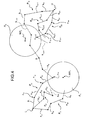
- Figures 1 and 3 relate to the calculation of a path constrained to pass through a single intermediate waypoint WP and Figures 2 and 4 relate to the calculation of a path constrained to pass through two intermediate waypoints, which are indicated WP 1 and WP 2 . respectively, and whose sequential order along the path is preset by the user.
- Any other path constrained to pass through a number of intermediate waypoints greater than two can be calculated on the basis of one of the specific situations illustrated, that is, of the situation with a single intermediate waypoint for an odd number of waypoints and of the situation with two intermediate waypoints for an even number of waypoints.
- the constant C preferably adopts a value of between 0.1 and 0.9, and even more preferably is equal to 0.35.
- this maximum value can be specified as the maximum value of the approach radius and, in the currently preferred embodiment, is equal to 40 km.
- the path-calculation method comprises the calculation of a plurality of forward partial paths P 1, f , P 2,f , P 3,f originating from the starting point L and directed towards a provisional destination point represented by the preset intermediate waypoint WP, and the calculation of a plurality of backward partial paths P 1,b , P 2,b , P 3,b originating from the destination point D and directed towards a provisional destination point represented by the preset intermediate waypoint WP.
- a score is attributed to each complete calculated path, in accordance with a predetermined criterion (for example, shorter distance or faster journey) and, if the path is entirely outside the area surrounding the waypoint WP or has a solution point outside that area, a penalty is applied (optionally modulated according to the distance between the solution and the perimeter of the surrounding area).
- a predetermined criterion for example, shorter distance or faster journey
- the path which has the highest score, or the lowest cost function taking account of the respective scores and penalties, is selected from a plurality of complete paths arising from the calculation of respective solution points S at which forward partial paths P i,f and backward partial paths P i,b meet.
- conditions equivalent to the reaching of an access node to the area surrounding the provisional destination point WP by at least one of the partial paths are: i) the reaching of a predetermined number of access nodes to the area surrounding the provisional destination point by the plurality of calculated partial paths and ii) the reaching of a predetermined maximum number of transit nodes by the plurality of partial paths, starting from the moment at which a first access node to the area surrounding the provisional destination point is reached.
- the second alternative ensures greater proximity to the waypoint.
- the sequential order of the intermediate waypoints is advantageously established by the user.
- the path-calculation method comprises the calculation of a plurality of forward partial paths P 1, f , P 2, f , P 3,f originating from the starting point L and directed towards a respective first provisional destination point represented by the first preset intermediate waypoint WP 1 , and the calculation of a plurality of backward partial paths P 1, b , P 2, b , P 3, b originating from the destination point D and directed towards a respective first provisional destination point represented by the second preset intermediate waypoint WP 2 .
- a score is attributed to each complete calculated path in accordance with a predetermined criterion (for example, shorter distance or faster journey) and, if the path is entirely outside one or more of the areas surrounding the waypoints WP 1 and WP 2 , a proportional penalty (optionally modulated according to the distance from those surrounding areas) is applied.
- a proportional penalty is not applied with respect to the location of a solution point because, since it must theoretically be situated halfway between the two intermediate waypoints, it certainly cannot fall within an area surrounding one of them.
- the path which has the best score, or the lowest cost function taking account of the respective scores and penalties, is selected from a plurality of complete paths arising from the calculation of respective solution points S at which forward partial paths P i,f and backward partial paths P i,b meet.
- a vehicle-mounted or portable navigation system 10 comprises a processing unit 12 arranged to calculate paths on the basis of a cartographic road map 14 stored on a storage substrate 16, and non-volatile memory means 18 carrying a processing program or set of programmes 20 which can be executed by the processing unit and comprising one or more code modules for the implementation of the calculation method as described above.
Abstract
- the establishment of a respective surrounding area (Ak) for each preset intermediate waypoint (WPk),
- the calculation of at least one forward partial path (Pi,f) originating from the starting point (L) and directed towards a provisional destination point represented by a preset intermediate waypoint (WPk),
- the calculation of at least one backward partial path (Pi,b) originating from the destination point (D) and directed towards a provisional destination point represented by a preset intermediate waypoint (WPk'), and
when at least one transit node (nij) forming part of the surrounding area (Ak) of a provisional destination point (WPk; WPk') has been reached,
- the diversion of the partial paths (Pi,f, Pi,b) that are directed towards the provisional destination point (WPk; WPk') towards a next path-defining point (WPk+1) in a predetermined order of travel, if the partial path is a forward path (Pi,f), or towards a preceding path-defining point (WPk'-1) in the predetermined order of travel, if the partial path is a backward path (Pi,b),
a complete path (P) between the starting point (L) and the destination point (D) being obtained by the joining of a forward partial path (Pi,f) and a backward partial path (Pi,b) which meet at an intersection node.

Description
- The present invention relates to the automatic calculation of an optimal path from a starting point to a destination point, in particular for navigation systems such as vehicle-mounted or portable navigation systems.
- A computer-implemented method of calculating an optimal path between a starting point and a destination point of an urban or geographical road network, such as a road network stored on a substrate readable by a computer as an electronic map associated with the navigation system, comprises the definition of a series of contiguous elemental path sections in which each section connects a transit node to an adjacent transit node.
- There are known methods of calculating an optimal path between a starting point and a destination point that are based on a bidirectional path-development strategy, that is, on the calculation of a plurality of forward partial paths, originating from the starting point, and of a plurality of backward partial paths, originating from the destination point.
- The optimal complete path is selected from a plurality of complete paths arising from the meeting of individual forward and backward partial paths, on the basis of a predetermined criterion which may be, for example, the requirement for the fastest route or the shortest route between two locations.
- In the conventional use of a navigation system, a traveller often wishes to be able to constrain the calculation of the path to pass through a predetermined locality. In many of these cases, however, he does not necessarily intend to require reaching and passing through the locality indicated, for example, the urban centre of a large city, but he simply wishes to be able to require passing near such locality in order to select a preferred subset of solutions.
- In this case, it is particularly disadvantageous for the navigation algorithm to interpret the programmer's instruction as a requirement to pass through the centre of the locality since it risks suggesting an unnecessary diversion, often lengthening the journey time or the overall distance to be travelled in comparison with optimal solutions which would be achieved by coming close to the waypoint locality indicated without passing through it.
- The object of the present invention is to provide an improved method of calculating an optimal path between a starting point and a destination point and constrained to pass through an area surrounding at least one intermediate waypoint.
- According to the present invention, this object is achieved by means of a method having the characteristics specified in
Claim 1. - Further subjects of the invention are a navigation system and a processing program or set of programs, as claimed.
- Specific embodiments of the invention form the subjects of the dependent claims.
- Further characteristics and advantages of the invention will be described in greater detail in the following specific description which is given by way of non-limiting example with reference to the appended drawings, in which:
-
Figure 1 is a schematic representation of the principal components defining a desired path constrained to pass through a single intermediate waypoint, -
Figure 2 is a schematic representation of the principal components defining a desired path constrained to pass through two intermediate waypoints, -
Figure 3 is a schematic representation of the calculation of a path in a configuration having the components ofFigure 1 , according to the calculation method of the invention, -
Figure 4 is a schematic representation of the calculation of a path in a configuration having the components ofFigure 2 , according to the calculation method of the invention, and -
Figure 5 is a diagram of a navigation system programmed to implement the path-calculation method of the invention. - In a navigation system, a desired path is defined by a starting point L, a destination point D and, optionally, intermediate waypoints WPk (k index variable from 1 to a number of waypoints predetermined by the user) which together constitute the points defining the path.
- The calculated path as a whole includes a plurality of contiguous elemental sections in sequence, each of which joins a transit node to an adjacent transit node of a cartographic road map stored on a storage substrate readable by a computer.
- The forward and backward partial paths, which are calculated in the course of the execution of the method in accordance with a two-dimensional development strategy, are indicated Pi, f and Pi, b, respectively, in the drawings, the individual sections making up the paths are indicated Sij, and the transit nodes forming part of the path are indicated nij.
-
Figures 1 and3 relate to the calculation of a path constrained to pass through a single intermediate waypoint WP andFigures 2 and4 relate to the calculation of a path constrained to pass through two intermediate waypoints, which are indicated WP1 and WP2. respectively, and whose sequential order along the path is preset by the user. - Any other path constrained to pass through a number of intermediate waypoints greater than two can be calculated on the basis of one of the specific situations illustrated, that is, of the situation with a single intermediate waypoint for an odd number of waypoints and of the situation with two intermediate waypoints for an even number of waypoints.
- Therefore, in the following a detailed analysis will be made with respect to the calculation methods adopted in the two reference types, since they can readily be extended to types of path with different numbers of intermediate waypoints.
- A surrounding area Ak is defined for each intermediate waypoint WPk, which is preferably of circular shape with an approach radius Rk to the respective central waypoint calculated in accordance with the following equation:

that is, equal to a predetermined fraction of the minimum among the theoretical distance (estimated as the crow-fly distance) of the intermediate waypoint in question from a preceding path-defining point (the starting point or a preceding intermediate waypoint) indicated dk, k-1, and the theoretical distance of the intermediate waypoint in question from a next path-defining point (a subsequent intermediate waypoint or the destination point) indicated dk+1, k • - The constant C preferably adopts a value of between 0.1 and 0.9, and even more preferably is equal to 0.35.
- In any case, it is advantageous to limit the extent of the surrounding areas to a predetermined maximum value, for example, depending on the largest metropolitan area existing in the geographical region covered by the cartographic road map, or at world level, beyond which value they cannot be further extended. For circular surrounding areas, this maximum value can be specified as the maximum value of the approach radius and, in the currently preferred embodiment, is equal to 40 km.
- In the first type of path that is taken as an example, that is, a path with a single intermediate waypoint WP, the path-calculation method comprises the calculation of a plurality of forward partial paths P1, f, P2,f, P3,f originating from the starting point L and directed towards a provisional destination point represented by the preset intermediate waypoint WP, and the calculation of a plurality of backward partial paths P1,b, P2,b, P3,b originating from the destination point D and directed towards a provisional destination point represented by the preset intermediate waypoint WP.
- When a transit node (n24 in
Figure 3 ) which forms part of the area A surrounding the provisional destination point WP and which is known as the "access node" to the area surrounding WP is reached by at least one of the partial paths, or when a predetermined equivalent condition is satisfied, all of the partial paths that have been developed in parallel are diverted towards the next path-defining point. If the partial path is a forward path, it is diverted towards the destination point D. If the partial path is a backward path, it is diverted towards the starting point L. - When a forward path and a backward path meet at an intersection node or solution point S, a complete path between the starting point and the destination point is established and their development is stopped.
- A score is attributed to each complete calculated path, in accordance with a predetermined criterion (for example, shorter distance or faster journey) and, if the path is entirely outside the area surrounding the waypoint WP or has a solution point outside that area, a penalty is applied (optionally modulated according to the distance between the solution and the perimeter of the surrounding area).
- The path which has the highest score, or the lowest cost function taking account of the respective scores and penalties, is selected from a plurality of complete paths arising from the calculation of respective solution points S at which forward partial paths Pi,f and backward partial paths Pi,b meet.
- To bring about the diversion of a partial path towards the next path-defining point, conditions equivalent to the reaching of an access node to the area surrounding the provisional destination point WP by at least one of the partial paths are: i) the reaching of a predetermined number of access nodes to the area surrounding the provisional destination point by the plurality of calculated partial paths and ii) the reaching of a predetermined maximum number of transit nodes by the plurality of partial paths, starting from the moment at which a first access node to the area surrounding the provisional destination point is reached. The second alternative ensures greater proximity to the waypoint.
- The calculation of a path constrained to an odd number of intermediate waypoints is based on the type of calculation defined above, substantially with the application of the same rules.
- When the first intermediate waypoint WP1 has been reached from the starting point, the forward partial paths Pi, f are diverted towards the next intermediate waypoint WP2.
- Simultaneously, when the last intermediate waypoint WPn has been reached from the destination point, the backward partial paths Pi,b are diverted towards the preceding intermediate waypoint WPn-1•
- The calculation continues until a stage is reached at which the forward and backward partial paths are attracted towards a common intermediate waypoint WP(n+1)/2, which again corresponds to the situation for a single waypoint WP.
- The sequential order of the intermediate waypoints is advantageously established by the user.
- The complete solution paths are always found when the forward and backward paths meet, and the path which has the best score, or the lowest cost function taking account of the respective scores and penalties, is selected therefrom as the optimal path P.
- In the second type of path described by way of example, that is, a path with two intermediate waypoints WP1 and WP2, the path-calculation method comprises the calculation of a plurality of forward partial paths P1, f, P2, f, P3,f originating from the starting point L and directed towards a respective first provisional destination point represented by the first preset intermediate waypoint WP1, and the calculation of a plurality of backward partial paths P1, b, P2, b, P3, b originating from the destination point D and directed towards a respective first provisional destination point represented by the second preset intermediate waypoint WP2.
- When a transit node (n13 in
Figure 4 ) forming part of the area A1 surrounding the provisional destination point WP1, known as the "access node" to the surrounding area WP1, is reached by at least one of the forward partial paths, or when a predetermined equivalent condition has been satisfied, all of the forward partial paths which have been developed in parallel are diverted towards the next intermediate waypoint WP2. - Simultaneously, when a transit node (n3, n-2 in
Figure 4 ) forming part of the area A2 surrounding the provisional destination point WP2, known as the "access node" to the surrounding area WP2, is reached by at least one of the backward partial paths, or when a predetermined equivalent condition has been satisfied, all of the backward partial paths which have been developed in parallel are diverted towards the preceding intermediate waypoint WP1. - When a forward path and a backward path meet at an intersection node or solution point S, a complete path between the starting point and the destination point is established and their development is stopped.
- A score is attributed to each complete calculated path in accordance with a predetermined criterion (for example, shorter distance or faster journey) and, if the path is entirely outside one or more of the areas surrounding the waypoints WP1 and WP2, a proportional penalty (optionally modulated according to the distance from those surrounding areas) is applied. Naturally, a penalty is not applied with respect to the location of a solution point because, since it must theoretically be situated halfway between the two intermediate waypoints, it certainly cannot fall within an area surrounding one of them.
- The path which has the best score, or the lowest cost function taking account of the respective scores and penalties, is selected from a plurality of complete paths arising from the calculation of respective solution points S at which forward partial paths Pi,f and backward partial paths Pi,b meet.
- The conditions equivalent to the reaching of an access node to the area surrounding a provisional destination point WP1 or WP2 by at least one of the partial paths in order to bring about the diversion of a partial path towards the next path-defining point are similar to those given in the preceding example.
- The calculation of a path constrained to an even number of intermediate waypoints is based on the type of calculation defined above, substantially with the application of the same rules.
- When the first intermediate waypoint WP1 has been reached from the starting point, the forward partial paths Pi,f are diverted towards the next intermediate waypoint WP2.
- Simultaneously, when the last intermediate waypoint WPn has been reached from the destination point, the backward partial paths Pi,b are diverted towards the preceding intermediate waypoint WPn-1•
- The calculation continues until a stage is reached at which the forward and backward partial paths are attracted towards respective central intermediate waypoints WPn/2 and WP(n/2)+1, which again corresponds to the situation for two waypoints WP1 and WP2.
- The complete solution paths are always found when the forward and backward partial paths meet, and the path which has the best score, or the lowest cost function taking account of the respective scores and penalties, is selected therefrom as the optimal path P.
- A vehicle-mounted or
portable navigation system 10 comprises aprocessing unit 12 arranged to calculate paths on the basis of acartographic road map 14 stored on astorage substrate 16, and non-volatile memory means 18 carrying a processing program or set ofprogrammes 20 which can be executed by the processing unit and comprising one or more code modules for the implementation of the calculation method as described above. - Naturally, the principle of the invention remaining the same, the forms of embodiment and details of construction may be varied widely with respect to those described and illustrated purely by way of non-limiting example, without thereby departing from the scope of protection of the present invention defined by the appended claims.
Claims (15)
- A computer-implemented method of calculating an optimal path between a starting point (L) and a destination point (D) of a cartographic road map stored on a storage substrate readable by a computer, and passing through at least one predetermined intermediate waypoint (WPk), the path being defined by a series of contiguous elemental sections (sij) in which each section joins a transit node (nij) to an adjacent transit node (ni j+1), the starting and destination points and the intermediate waypoints (L, D, WPk) constituting a set of points defining the desired path,
characterized in that it comprises:- the establishment of a respective surrounding area (Ak) for each preset intermediate waypoint (WPk),- the calculation of at least one forward partial path (Pi, f) originating from the starting point (L) and directed towards a provisional destination point represented by a preset intermediate waypoint (WPk),- the calculation of at least one backward partial path (Pi,b) originating from the destination point (D) and directed towards a provisional destination point represented by a preset intermediate waypoint (WPk'), andwhen at least one transit node (nij) forming part of the surrounding area (Ak) of a provisional destination point (WPk; WPk') has been reached,- the diversion of the partial paths (Pi, f, Pi,b) that are directed towards the provisional destination point (WPk; WPk') towards a next path-defining point (WPk+1) in a predetermined order of travel, if the partial path is a forward path (Pi,f), or towards a preceding path-defining point (WPk'-1) in the predetermined order of travel, if the partial path is a backward path (Pi,b) ,a complete path (P) between the starting point (L) and the destination point (D) being obtained by the joining of a forward partial path (Pi,f) and a backward partial path (Pi,b) which meet at an intersection node. - A method according to Claim 1, characterized in that it comprises, when at least one transit node (nij) forming part of the surrounding area (Ak) of the provisional destination point (WPk) has been reached, the diversion of the partial paths (Pi, f, Pi,b) that are directed towards the provisional destination point (WPk), towards:i) the destination point (D) if the partial path is a forward path (Pi,f) and a single required intermediate waypoint (WP) is preset;ii) the starting point (L) if the partial path is a backward path (Pi,b) and a single required intermediate waypoint (WP) is preset;iii) a further, provisional destination point represented by a next preset intermediate waypoint (WPk+1) in a predetermined order of travel, if the partial path is a forward path (Pi, f) and a plurality of required intermediate waypoints (WPk) are preset;iv) a further, provisional destination point represented by a preceding preset intermediate waypoint (WPk-1) in a predetermined order of travel, if the partial path is a backward path (Pi, b) and a plurality of required intermediate waypoints (WPk) are preset.
- A method according to Claim 1 or Claim 2, characterized in that it comprises the calculation of a plurality of forward and backward partial paths (Pi,f, Pi,b), the obtaining of a plurality of complete paths (Pi) by the joining of a respective forward partial path (Pi,f) and a respective backward partial path (Pi,b) which meet at a respective intersection node, and the selection of the optimal complete path on the basis of at least one predetermined criterion.
- A method according to Claim 3, characterized in that the predetermined criterion comprises the calculation of a cost function.
- A method according to Claim 4, characterized in that the cost function is calculated on the basis of scores assigned in accordance with a predetermined rule and penalties attributed to the complete path solutions that are outside the surrounding areas (Ak) of the intermediate waypoints (WPk) .
- A method according to Claim 4, characterized in that the cost function is calculated on the basis of scores assigned in accordance with a predetermined rule and penalties attributed to the complete path solutions of which the intersection nodes between the partial forward paths (Pi,f) and the backward partial paths (Pi,b) are outside the surrounding areas (Ak) of the intermediate waypoints (WPk) .
- A method according to any one of the preceding claims, characterized in that the surrounding area (Ak) is established as a circular area of a radius (Rk) which is equal to a predetermined fraction of the minimum among the theoretical distance of the intermediate waypoint (WPk) from a preceding path-defining point (L; WPk-1), and from a next path-defining point (D; WPk+1).
- A method according to Claim 7, characterized in that the predetermined fraction is equal to 0.35.
- A method according to Claim 7 or 8, characterized in that the surrounding area has a predetermined maximum radius equal to 40 km.
- A method according to any one of the preceding claims, characterized in that it comprises the diversion of a partial path (Pi,f; Pi,b) towards a different path-defining point when a first access transit node (nij) to the surrounding area (Ak) of the current provisional destination point (WPk) is reached by one of the partial paths (Pi,f, Pi,b).
- A method according to any one of Claims 1 to 9, characterized in that it comprises the diversion of a partial path (Pi,f; Pi,b) towards a different path-defining point when a predetermined number of transit access nodes (nij) to the surrounding area (Ak) of the current provisional destination point (WPk) is reached by the plurality of partial paths (Pi,f; Pi,b).
- A method according to any one of Claims 1 to 9, characterized in that it comprises the diversion of a partial path (Pi,f; Pi,b) towards a different path-defining point when a predetermined maximum number of transit nodes (nij) is reached by the plurality of partial paths (Pi,f; Pi,b), starting from the moment at which the first access node to the surrounding area (Ak) of the current provisional destination point (WPk) is reached.
- A method according to any one of the preceding claims, characterized in that it comprises the definition by the user of the sequential order of the required intermediate waypoints (WPk) along the path.
- A navigation system for the calculation of an optimal path between a starting point (L) and a destination point (D) passing through at least one intermediate point (WPk), programmed to implement a method according to any one of Claims 1 to 13.
- A computer program or set of programs which can be executed by a processing system and which comprise/s one or more code modules for the implementation of a method of calculating an optimal path between a starting point (L) and a destination point (D) passing through at least one intermediate point (WPk), in accordance with any one of Claims 1 to 13.
Priority Applications (2)
| Application Number | Priority Date | Filing Date | Title |
|---|---|---|---|
| TR2018/07691T TR201807691T4 (en) | 2006-12-29 | 2006-12-29 | A method for calculating an optimal route between a starting point and a destination and which is forced to pass through an intermediate point, a navigation system and a corresponding computer program product. |
| EP06425869.2A EP1939590B1 (en) | 2006-12-29 | 2006-12-29 | A method of calculating an optimal path between a starting point and a destination point, and constrained to pass through an intermediate waypoint, a navigation system and a corresponding computer program product |
Applications Claiming Priority (1)
| Application Number | Priority Date | Filing Date | Title |
|---|---|---|---|
| EP06425869.2A EP1939590B1 (en) | 2006-12-29 | 2006-12-29 | A method of calculating an optimal path between a starting point and a destination point, and constrained to pass through an intermediate waypoint, a navigation system and a corresponding computer program product |
Publications (2)
| Publication Number | Publication Date |
|---|---|
| EP1939590A1 true EP1939590A1 (en) | 2008-07-02 |
| EP1939590B1 EP1939590B1 (en) | 2018-03-07 |
Family
ID=38171620
Family Applications (1)
| Application Number | Title | Priority Date | Filing Date |
|---|---|---|---|
| EP06425869.2A Active EP1939590B1 (en) | 2006-12-29 | 2006-12-29 | A method of calculating an optimal path between a starting point and a destination point, and constrained to pass through an intermediate waypoint, a navigation system and a corresponding computer program product |
Country Status (2)
| Country | Link |
|---|---|
| EP (1) | EP1939590B1 (en) |
| TR (1) | TR201807691T4 (en) |
Cited By (6)
| Publication number | Priority date | Publication date | Assignee | Title |
|---|---|---|---|---|
| US20140200807A1 (en) * | 2013-01-17 | 2014-07-17 | Google Inc. | Route Planning |
| WO2015039182A1 (en) * | 2013-09-19 | 2015-03-26 | National Ict Australia Limited | Determining network maps of transport networks |
| WO2019021134A1 (en) * | 2017-07-28 | 2019-01-31 | Uber Technologies, Inc. | Dynamically determining origin and destination locations for a network system |
| WO2019164727A1 (en) * | 2018-02-20 | 2019-08-29 | Grzegorz Malewicz | A method and an apparatus for searching or comparing sites using routes or route lengths between sites and places within a transportation system |
| CN112102650A (en) * | 2019-06-18 | 2020-12-18 | 波音公司 | Method and device for generating diversion route and storage medium |
| CN112904837A (en) * | 2019-12-03 | 2021-06-04 | 北京京东乾石科技有限公司 | Data processing method, device and computer readable storage medium |
Citations (5)
| Publication number | Priority date | Publication date | Assignee | Title |
|---|---|---|---|---|
| EP0504854A1 (en) * | 1991-03-19 | 1992-09-23 | Matsushita Electric Industrial Co., Ltd. | Route selection method and apparatus therefor |
| EP0726447A1 (en) * | 1995-02-09 | 1996-08-14 | Zexel Corporation | Incremental route calculation |
| EP0854353A2 (en) * | 1997-01-15 | 1998-07-22 | Zexel Corporation | Route determination in a vehicle navigation system |
| EP1267146A1 (en) * | 2001-06-15 | 2002-12-18 | Siemens Aktiengesellschaft | A method for operating a route planning system for a motor vehicle, a navigation system arranged for implementing such method, and a motor vehicle comprising such interactive navigation system |
| US20040039520A1 (en) * | 1998-03-25 | 2004-02-26 | Asta Khavakh | Method and system for route calculation in a navigation application |
-
2006
- 2006-12-29 EP EP06425869.2A patent/EP1939590B1/en active Active
- 2006-12-29 TR TR2018/07691T patent/TR201807691T4/en unknown
Patent Citations (5)
| Publication number | Priority date | Publication date | Assignee | Title |
|---|---|---|---|---|
| EP0504854A1 (en) * | 1991-03-19 | 1992-09-23 | Matsushita Electric Industrial Co., Ltd. | Route selection method and apparatus therefor |
| EP0726447A1 (en) * | 1995-02-09 | 1996-08-14 | Zexel Corporation | Incremental route calculation |
| EP0854353A2 (en) * | 1997-01-15 | 1998-07-22 | Zexel Corporation | Route determination in a vehicle navigation system |
| US20040039520A1 (en) * | 1998-03-25 | 2004-02-26 | Asta Khavakh | Method and system for route calculation in a navigation application |
| EP1267146A1 (en) * | 2001-06-15 | 2002-12-18 | Siemens Aktiengesellschaft | A method for operating a route planning system for a motor vehicle, a navigation system arranged for implementing such method, and a motor vehicle comprising such interactive navigation system |
Cited By (13)
| Publication number | Priority date | Publication date | Assignee | Title |
|---|---|---|---|---|
| US9175972B2 (en) * | 2013-01-17 | 2015-11-03 | Google Inc. | Route planning |
| US20140200807A1 (en) * | 2013-01-17 | 2014-07-17 | Google Inc. | Route Planning |
| WO2015039182A1 (en) * | 2013-09-19 | 2015-03-26 | National Ict Australia Limited | Determining network maps of transport networks |
| US10359291B2 (en) | 2013-09-19 | 2019-07-23 | National Ict Australia Limited | Determining network maps of transport networks |
| AU2020203551B2 (en) * | 2017-07-28 | 2021-07-01 | Uber Technologies, Inc. | Dynamically determining origin and destination locations for a network system |
| WO2019021134A1 (en) * | 2017-07-28 | 2019-01-31 | Uber Technologies, Inc. | Dynamically determining origin and destination locations for a network system |
| US10330482B2 (en) | 2017-07-28 | 2019-06-25 | Uber Technologies, Inc. | Dynamically determining origin and destination locations for a network system |
| AU2018307710B2 (en) * | 2017-07-28 | 2020-03-12 | Uber Technologies, Inc. | Dynamically determining origin and destination locations for a network system |
| US11150098B2 (en) | 2017-07-28 | 2021-10-19 | Uber Technologies, Inc. | Dynamically determining origin and destination locations for a network system |
| WO2019164727A1 (en) * | 2018-02-20 | 2019-08-29 | Grzegorz Malewicz | A method and an apparatus for searching or comparing sites using routes or route lengths between sites and places within a transportation system |
| CN112102650A (en) * | 2019-06-18 | 2020-12-18 | 波音公司 | Method and device for generating diversion route and storage medium |
| CN112102650B (en) * | 2019-06-18 | 2024-04-05 | 波音公司 | Navigation route changing generation method, device and storage medium |
| CN112904837A (en) * | 2019-12-03 | 2021-06-04 | 北京京东乾石科技有限公司 | Data processing method, device and computer readable storage medium |
Also Published As
| Publication number | Publication date |
|---|---|
| EP1939590B1 (en) | 2018-03-07 |
| TR201807691T4 (en) | 2018-06-21 |
Similar Documents
| Publication | Publication Date | Title |
|---|---|---|
| EP3658857B1 (en) | Dynamically determining origin and destination locations for a vehicle communicating with a network system | |
| EP1939590B1 (en) | A method of calculating an optimal path between a starting point and a destination point, and constrained to pass through an intermediate waypoint, a navigation system and a corresponding computer program product | |
| JP5831290B2 (en) | Branch probability prediction device | |
| JP4975711B2 (en) | Using multiple cost levels for route discovery calculations | |
| US5272638A (en) | Systems and methods for planning the scheduling travel routes | |
| CN102735239B (en) | Navigation device, method and system | |
| US11733058B2 (en) | Methods and systems for generating parking routes | |
| EP2306153A2 (en) | Navigation device and method for route calculation | |
| CA2854274C (en) | Autonomous travel system | |
| Kanoh et al. | Hybrid genetic algorithm for dynamic multi-objective route planning with predicted traffic in a real-world road network | |
| US7822540B2 (en) | Systems, methods, and programs for determining a travel-related time | |
| JPH01173298A (en) | System for retrieving path of navigation device | |
| US20080120022A1 (en) | Method and Device for Determining a Route with Points of Interest | |
| CN102042836B (en) | Navigation method, and navigation device | |
| US20060136123A1 (en) | Travel route mapping | |
| US20170069200A1 (en) | Method of collecting probe information, computer-readable recording media and travel time calculation apparatus | |
| CN109642800A (en) | Route searching method and route searching device | |
| CN105606116B (en) | A kind of air navigation aid, navigation device and its system of navigation of satisfying the need | |
| US20100030464A1 (en) | Route Finding System and Method Having a Route Option for Avoiding Hazardous Turning Maneuvers | |
| US8457890B2 (en) | Method for generating a digital road map, navigation system and method for operating a navigation system | |
| JPWO2010109762A1 (en) | NAVIGATION SYSTEM, NAVIGATION METHOD, COMPUTER PROGRAM FOR EXECUTING NAVIGATION METHOD, AND RECORDING MEDIUM CONTAINING THE COMPUTER PROGRAM | |
| US20130254147A1 (en) | Method and apparatus for ascertaining at least one exit probability from a land area identifiable in a digital map as open terrain | |
| EP3779363B1 (en) | Method and system for vehicle routing based on parking probabilities | |
| Nakajima et al. | Route recommendation method for car navigation system based on estimation of driver's intent | |
| Richter | Adaptable path planning in regionalized environments |
Legal Events
| Date | Code | Title | Description |
|---|---|---|---|
| PUAI | Public reference made under article 153(3) epc to a published international application that has entered the european phase |
Free format text: ORIGINAL CODE: 0009012 |
|
| AK | Designated contracting states |
Kind code of ref document: A1 Designated state(s): AT BE BG CH CY CZ DE DK EE ES FI FR GB GR HU IE IS IT LI LT LU LV MC NL PL PT RO SE SI SK TR |
|
| AX | Request for extension of the european patent |
Extension state: AL BA HR MK RS |
|
| 17P | Request for examination filed |
Effective date: 20081230 |
|
| AKX | Designation fees paid |
Designated state(s): AT BE BG CH CY CZ DE DK EE ES FI FR GB GR HU IE IS IT LI LT LU LV MC NL PL PT RO SE SI SK TR |
|
| 17Q | First examination report despatched |
Effective date: 20090428 |
|
| GRAP | Despatch of communication of intention to grant a patent |
Free format text: ORIGINAL CODE: EPIDOSNIGR1 |
|
| INTG | Intention to grant announced |
Effective date: 20170731 |
|
| GRAS | Grant fee paid |
Free format text: ORIGINAL CODE: EPIDOSNIGR3 |
|
| RAP1 | Party data changed (applicant data changed or rights of an application transferred) |
Owner name: MAGNETI MARELLI S.P.A. |
|
| GRAA | (expected) grant |
Free format text: ORIGINAL CODE: 0009210 |
|
| AK | Designated contracting states |
Kind code of ref document: B1 Designated state(s): AT BE BG CH CY CZ DE DK EE ES FI FR GB GR HU IE IS IT LI LT LU LV MC NL PL PT RO SE SI SK TR |
|
| REG | Reference to a national code |
Ref country code: GB Ref legal event code: FG4D |
|
| REG | Reference to a national code |
Ref country code: CH Ref legal event code: EP Ref country code: AT Ref legal event code: REF Ref document number: 977057 Country of ref document: AT Kind code of ref document: T Effective date: 20180315 |
|
| REG | Reference to a national code |
Ref country code: IE Ref legal event code: FG4D |
|
| REG | Reference to a national code |
Ref country code: DE Ref legal event code: R096 Ref document number: 602006054852 Country of ref document: DE |
|
| REG | Reference to a national code |
Ref country code: NL Ref legal event code: MP Effective date: 20180307 |
|
| REG | Reference to a national code |
Ref country code: LT Ref legal event code: MG4D |
|
| PG25 | Lapsed in a contracting state [announced via postgrant information from national office to epo] |
Ref country code: CY Free format text: LAPSE BECAUSE OF FAILURE TO SUBMIT A TRANSLATION OF THE DESCRIPTION OR TO PAY THE FEE WITHIN THE PRESCRIBED TIME-LIMIT Effective date: 20180307 Ref country code: FI Free format text: LAPSE BECAUSE OF FAILURE TO SUBMIT A TRANSLATION OF THE DESCRIPTION OR TO PAY THE FEE WITHIN THE PRESCRIBED TIME-LIMIT Effective date: 20180307 Ref country code: LT Free format text: LAPSE BECAUSE OF FAILURE TO SUBMIT A TRANSLATION OF THE DESCRIPTION OR TO PAY THE FEE WITHIN THE PRESCRIBED TIME-LIMIT Effective date: 20180307 Ref country code: ES Free format text: LAPSE BECAUSE OF FAILURE TO SUBMIT A TRANSLATION OF THE DESCRIPTION OR TO PAY THE FEE WITHIN THE PRESCRIBED TIME-LIMIT Effective date: 20180307 |
|
| REG | Reference to a national code |
Ref country code: AT Ref legal event code: MK05 Ref document number: 977057 Country of ref document: AT Kind code of ref document: T Effective date: 20180307 |
|
| PG25 | Lapsed in a contracting state [announced via postgrant information from national office to epo] |
Ref country code: LV Free format text: LAPSE BECAUSE OF FAILURE TO SUBMIT A TRANSLATION OF THE DESCRIPTION OR TO PAY THE FEE WITHIN THE PRESCRIBED TIME-LIMIT Effective date: 20180307 Ref country code: SE Free format text: LAPSE BECAUSE OF FAILURE TO SUBMIT A TRANSLATION OF THE DESCRIPTION OR TO PAY THE FEE WITHIN THE PRESCRIBED TIME-LIMIT Effective date: 20180307 Ref country code: BG Free format text: LAPSE BECAUSE OF FAILURE TO SUBMIT A TRANSLATION OF THE DESCRIPTION OR TO PAY THE FEE WITHIN THE PRESCRIBED TIME-LIMIT Effective date: 20180607 Ref country code: GR Free format text: LAPSE BECAUSE OF FAILURE TO SUBMIT A TRANSLATION OF THE DESCRIPTION OR TO PAY THE FEE WITHIN THE PRESCRIBED TIME-LIMIT Effective date: 20180608 |
|
| PG25 | Lapsed in a contracting state [announced via postgrant information from national office to epo] |
Ref country code: RO Free format text: LAPSE BECAUSE OF FAILURE TO SUBMIT A TRANSLATION OF THE DESCRIPTION OR TO PAY THE FEE WITHIN THE PRESCRIBED TIME-LIMIT Effective date: 20180307 Ref country code: NL Free format text: LAPSE BECAUSE OF FAILURE TO SUBMIT A TRANSLATION OF THE DESCRIPTION OR TO PAY THE FEE WITHIN THE PRESCRIBED TIME-LIMIT Effective date: 20180307 Ref country code: PL Free format text: LAPSE BECAUSE OF FAILURE TO SUBMIT A TRANSLATION OF THE DESCRIPTION OR TO PAY THE FEE WITHIN THE PRESCRIBED TIME-LIMIT Effective date: 20180307 Ref country code: EE Free format text: LAPSE BECAUSE OF FAILURE TO SUBMIT A TRANSLATION OF THE DESCRIPTION OR TO PAY THE FEE WITHIN THE PRESCRIBED TIME-LIMIT Effective date: 20180307 |
|
| PG25 | Lapsed in a contracting state [announced via postgrant information from national office to epo] |
Ref country code: SK Free format text: LAPSE BECAUSE OF FAILURE TO SUBMIT A TRANSLATION OF THE DESCRIPTION OR TO PAY THE FEE WITHIN THE PRESCRIBED TIME-LIMIT Effective date: 20180307 Ref country code: CZ Free format text: LAPSE BECAUSE OF FAILURE TO SUBMIT A TRANSLATION OF THE DESCRIPTION OR TO PAY THE FEE WITHIN THE PRESCRIBED TIME-LIMIT Effective date: 20180307 Ref country code: AT Free format text: LAPSE BECAUSE OF FAILURE TO SUBMIT A TRANSLATION OF THE DESCRIPTION OR TO PAY THE FEE WITHIN THE PRESCRIBED TIME-LIMIT Effective date: 20180307 |
|
| REG | Reference to a national code |
Ref country code: DE Ref legal event code: R097 Ref document number: 602006054852 Country of ref document: DE |
|
| PG25 | Lapsed in a contracting state [announced via postgrant information from national office to epo] |
Ref country code: PT Free format text: LAPSE BECAUSE OF FAILURE TO SUBMIT A TRANSLATION OF THE DESCRIPTION OR TO PAY THE FEE WITHIN THE PRESCRIBED TIME-LIMIT Effective date: 20180709 |
|
| PLBE | No opposition filed within time limit |
Free format text: ORIGINAL CODE: 0009261 |
|
| STAA | Information on the status of an ep patent application or granted ep patent |
Free format text: STATUS: NO OPPOSITION FILED WITHIN TIME LIMIT |
|
| PG25 | Lapsed in a contracting state [announced via postgrant information from national office to epo] |
Ref country code: DK Free format text: LAPSE BECAUSE OF FAILURE TO SUBMIT A TRANSLATION OF THE DESCRIPTION OR TO PAY THE FEE WITHIN THE PRESCRIBED TIME-LIMIT Effective date: 20180307 |
|
| 26N | No opposition filed |
Effective date: 20181210 |
|
| PG25 | Lapsed in a contracting state [announced via postgrant information from national office to epo] |
Ref country code: SI Free format text: LAPSE BECAUSE OF FAILURE TO SUBMIT A TRANSLATION OF THE DESCRIPTION OR TO PAY THE FEE WITHIN THE PRESCRIBED TIME-LIMIT Effective date: 20180307 |
|
| REG | Reference to a national code |
Ref country code: CH Ref legal event code: PL |
|
| GBPC | Gb: european patent ceased through non-payment of renewal fee |
Effective date: 20181229 |
|
| PG25 | Lapsed in a contracting state [announced via postgrant information from national office to epo] |
Ref country code: LU Free format text: LAPSE BECAUSE OF NON-PAYMENT OF DUE FEES Effective date: 20181229 Ref country code: MC Free format text: LAPSE BECAUSE OF FAILURE TO SUBMIT A TRANSLATION OF THE DESCRIPTION OR TO PAY THE FEE WITHIN THE PRESCRIBED TIME-LIMIT Effective date: 20180307 |
|
| REG | Reference to a national code |
Ref country code: BE Ref legal event code: MM Effective date: 20181231 Ref country code: IE Ref legal event code: MM4A |
|
| PG25 | Lapsed in a contracting state [announced via postgrant information from national office to epo] |
Ref country code: IE Free format text: LAPSE BECAUSE OF NON-PAYMENT OF DUE FEES Effective date: 20181229 |
|
| PG25 | Lapsed in a contracting state [announced via postgrant information from national office to epo] |
Ref country code: BE Free format text: LAPSE BECAUSE OF NON-PAYMENT OF DUE FEES Effective date: 20181231 |
|
| PG25 | Lapsed in a contracting state [announced via postgrant information from national office to epo] |
Ref country code: CH Free format text: LAPSE BECAUSE OF NON-PAYMENT OF DUE FEES Effective date: 20181231 Ref country code: GB Free format text: LAPSE BECAUSE OF NON-PAYMENT OF DUE FEES Effective date: 20181229 Ref country code: LI Free format text: LAPSE BECAUSE OF NON-PAYMENT OF DUE FEES Effective date: 20181231 |
|
| PG25 | Lapsed in a contracting state [announced via postgrant information from national office to epo] |
Ref country code: HU Free format text: LAPSE BECAUSE OF FAILURE TO SUBMIT A TRANSLATION OF THE DESCRIPTION OR TO PAY THE FEE WITHIN THE PRESCRIBED TIME-LIMIT; INVALID AB INITIO Effective date: 20061229 |
|
| PG25 | Lapsed in a contracting state [announced via postgrant information from national office to epo] |
Ref country code: IS Free format text: LAPSE BECAUSE OF FAILURE TO SUBMIT A TRANSLATION OF THE DESCRIPTION OR TO PAY THE FEE WITHIN THE PRESCRIBED TIME-LIMIT Effective date: 20180707 |
|
| PGFP | Annual fee paid to national office [announced via postgrant information from national office to epo] |
Ref country code: IT Payment date: 20221122 Year of fee payment: 17 |
|
| PGFP | Annual fee paid to national office [announced via postgrant information from national office to epo] |
Ref country code: TR Payment date: 20231129 Year of fee payment: 18 Ref country code: FR Payment date: 20231122 Year of fee payment: 18 Ref country code: DE Payment date: 20231121 Year of fee payment: 18 |