EP1742191B1 - GPS-based traffic monitoring system - Google Patents
GPS-based traffic monitoring system Download PDFInfo
- Publication number
- EP1742191B1 EP1742191B1 EP06011022A EP06011022A EP1742191B1 EP 1742191 B1 EP1742191 B1 EP 1742191B1 EP 06011022 A EP06011022 A EP 06011022A EP 06011022 A EP06011022 A EP 06011022A EP 1742191 B1 EP1742191 B1 EP 1742191B1
- Authority
- EP
- European Patent Office
- Prior art keywords
- traffic
- parking
- vehicle
- location
- data
- Prior art date
- Legal status (The legal status is an assumption and is not a legal conclusion. Google has not performed a legal analysis and makes no representation as to the accuracy of the status listed.)
- Active
Links
Images


Classifications
-
- G—PHYSICS
- G08—SIGNALLING
- G08G—TRAFFIC CONTROL SYSTEMS
- G08G1/00—Traffic control systems for road vehicles
- G08G1/09—Arrangements for giving variable traffic instructions
- G08G1/0962—Arrangements for giving variable traffic instructions having an indicator mounted inside the vehicle, e.g. giving voice messages
- G08G1/0967—Systems involving transmission of highway information, e.g. weather, speed limits
- G08G1/096766—Systems involving transmission of highway information, e.g. weather, speed limits where the system is characterised by the origin of the information transmission
- G08G1/096775—Systems involving transmission of highway information, e.g. weather, speed limits where the system is characterised by the origin of the information transmission where the origin of the information is a central station
-
- G—PHYSICS
- G08—SIGNALLING
- G08G—TRAFFIC CONTROL SYSTEMS
- G08G1/00—Traffic control systems for road vehicles
- G08G1/01—Detecting movement of traffic to be counted or controlled
- G08G1/0104—Measuring and analyzing of parameters relative to traffic conditions
-
- G—PHYSICS
- G08—SIGNALLING
- G08G—TRAFFIC CONTROL SYSTEMS
- G08G1/00—Traffic control systems for road vehicles
- G08G1/09—Arrangements for giving variable traffic instructions
- G08G1/0962—Arrangements for giving variable traffic instructions having an indicator mounted inside the vehicle, e.g. giving voice messages
- G08G1/0967—Systems involving transmission of highway information, e.g. weather, speed limits
- G08G1/096708—Systems involving transmission of highway information, e.g. weather, speed limits where the received information might be used to generate an automatic action on the vehicle control
- G08G1/096716—Systems involving transmission of highway information, e.g. weather, speed limits where the received information might be used to generate an automatic action on the vehicle control where the received information does not generate an automatic action on the vehicle control
-
- G—PHYSICS
- G08—SIGNALLING
- G08G—TRAFFIC CONTROL SYSTEMS
- G08G1/00—Traffic control systems for road vehicles
- G08G1/09—Arrangements for giving variable traffic instructions
- G08G1/0962—Arrangements for giving variable traffic instructions having an indicator mounted inside the vehicle, e.g. giving voice messages
- G08G1/0967—Systems involving transmission of highway information, e.g. weather, speed limits
- G08G1/096733—Systems involving transmission of highway information, e.g. weather, speed limits where a selection of the information might take place
- G08G1/096741—Systems involving transmission of highway information, e.g. weather, speed limits where a selection of the information might take place where the source of the transmitted information selects which information to transmit to each vehicle
-
- G—PHYSICS
- G08—SIGNALLING
- G08G—TRAFFIC CONTROL SYSTEMS
- G08G1/00—Traffic control systems for road vehicles
- G08G1/14—Traffic control systems for road vehicles indicating individual free spaces in parking areas
-
- G—PHYSICS
- G08—SIGNALLING
- G08G—TRAFFIC CONTROL SYSTEMS
- G08G1/00—Traffic control systems for road vehicles
- G08G1/20—Monitoring the location of vehicles belonging to a group, e.g. fleet of vehicles, countable or determined number of vehicles
Definitions
- the present invention relates to traffic monitoring systems, and more particularly to global positioning system (GPS)-based traffic monitoring systems for vehicles.
- GPS global positioning system
- GPS Global positioning systems
- GPS systems typically include a receiver that triangulates vehicle position using beacons generated by GPS satellites.
- GPS systems also typically include a map database that is used to provide the location of the vehicle on a map, driving directions, the location of restaurants and other businesses, and/or other information.
- map database that is used to provide the location of the vehicle on a map, driving directions, the location of restaurants and other businesses, and/or other information.
- cities become more populated it has become more difficult to travel without incurring delays due to traffic congestion, accidents, construction and/or other problems. Finding parking in congested cities can also be difficult.
- US 6, 426, 709 B1 refers to a method for transmitting local data and measurement data from a terminal, including a telematic terminal, to a central traffic control unit.
- a reduction in a telecommunication costs in the transmission of extensive data from a telematic terminal unit in a vehicle to a central station is made possible by a method for the transmission of location data indicating the location of the terminal unit in a traffic network at a point in time and of measurement data indicating other characteristics of the traffic network at a location and/or at a time to the central traffic station, which location data and measurement data are detected by the terminal unit, particularly a telematic terminal unit for a vehicle.
- At least some of the data records transmitted from the terminal unit to the central traffic station contain only location data and some of the data records transmitted from the terminal unit to the central traffic station contain measurement data.
- EP 0 755 039 A2 refers to a method and system for prognosing of traffic flow. Prediction of road traffic conditions are performed based on random sampling.
- a sampling system has a number of vehicle activity sensors that are distributed over a wide geographical range and can be in mobile or fixed installations. These sensors communicate with the receivers of a traffic condition computer. The computer is in communication with a number of vehicles that are to be directed through the road system. The random sampling of the traffic conditions allows a prediction to be made of conditions and allows suitable routes to be established.
- US 2004/0246147 A1 refers to real time vehicular routing and traffic guidance system.
- a system is described that incorporates at least one wireless data receiver, capable of receiving from a plurality of participating transmitters, for example GPS enabled cell phones, such data as is required for determining the transmitter identification code, a sign on code, an optional routing code, describing a selected matrix of preferred and alternative routes and the location of the transmitter.
- a traffic monitoring system that comprises a traffic information system in a plurality of vehicles, wherein the traffic information system comprises a global positioning system (62, 62'), GPS, for selectively generating location and vector data; a transmitter; and a control module (65, 65') for receiving the location and vector data and for wirelessly transmitting the location and vector data by using the transmitter; a memory (110) for storing traffic data; and a traffic monitoring module (112) adapted for collecting the location and vector data for the plurality of vehicles (20, 24), when the vehicles are travelling on a first set of predetermined roads; storing the location and vector data in the memory (110); analyzing the location and vector data; and generating traffic reports for the first set of predetermined roads based on the analyzed location and vector data; the traffic monitoring module (112) is further adapted for identifying vehicles having operational problems by comparing a speed of each vehicle on a first road with a first speed threshold, and by comparing an average traffic speed on the first road with a
- It is another aspect of the present invention to provide a method for providing traffic information that comprises the steps of receiving location and vector data from a plurality of vehicles travelling on a first set of roads; analyzing the location and vector data; generating traffic reports based on the location and vector data; diagnosing a possible problem with a first vehicle using the location and vector data by comparing (288) a speed of one of the vehicles on a first road with a first speed threshold and comparing an average traffic speed on the first road with a second speed threshold; and triggering a remote service assistance system (133) to contact a driver of the first vehicle, when the location and vector data indicate a possible problem based on the comparison.
- a traffic information system for a vehicle comprises a transmitter and a global positioning system (GPS) associated with the vehicle that selectively generates location and vector data.
- GPS global positioning system
- a control module receives the location and vector data and wirelessly transmits the location and vector data using the transmitter when the vehicle is traveling on a first set of predetermined roads.
- the control module does not transmit the location and vector data when the vehicle is traveling on a second set of predetermined roads.
- a receiver communicates with the control module and wirelessly receives traffic reports from a remote traffic monitoring system.
- the traffic reports include traffic speed information for traffic traveling on at least one road of the first set of predetermined roads.
- a service assistance system communicates with the control module and wirelessly communicates with a remote service assistance system.
- the remote traffic monitoring system receives the vector and location data and compares a speed of the vehicle on a first road to a first threshold and to an average traffic speed on the first road and selectively triggers contact with the vehicle using the service assistance system and the remote service assistance system.
- the traffic reports include parking status information for public parking spots.
- the parking status information for the public parking spots includes at least one status type selected from a group consisting of leaving, filled, open and unknown.
- control module transmits the vector and location data on a periodic basis.
- the control module monitors changes in direction of the vehicle and transmits the vector and location data when the vehicle changes direction greater than a direction change threshold.
- the control module monitors changes in speed of the vehicle and transmits the vector and location data when the vehicle speed change is greater than a speed change threshold.
- control module selectively transmits parking indication and location data using the transmitter when the vehicle ignition is turned off.
- the control module selectively transmits parking indication and location data using the transmitter when the vehicle ignition is turned off and the vehicle is parked in a public parking spot.
- the control module selectively transmits vector and location data using the transmitter when the vehicle leaves the public parking spot.
- control module selectively generates location and parking indication data when an engine of the vehicle is turned off and selectively transmits the location and parking indication data using the transmitter.
- a parking monitoring system located remotely from the vehicle receives the location and parking indication data from the vehicle and a plurality of other vehicles, generates parking status reports, and selectively transmits the parking status reports to the vehicle.
- a parking lot module associated with a parking lot identifies available parking spots in the parking lot and a parking lot transmitter transmits parking lot data related to the available parking spots to the parking monitoring system.
- a parking spot module associated with a parking spot identifies a filled status of the parking spot and a parking spot transmitter transmits parking spot data based on the filled status to the parking monitoring system.
- the parking status report is based in part on the parking lot data.
- the parking report is based in part on the parking spot data.
- the parking status reports include parking spot information related to parking spots within a predetermined distance of at least one vehicle.
- the parking spot information includes a parking status for parking spaces on at least one road.
- the parking status includes at least one selected from the group consisting of vacant, filled, unknown, and leaving.
- the control module is integrated with the GPS.
- a method for operating a traffic information system for a vehicle comprises selectively generating location and vector data using a global positioning system associated with a vehicle, wirelessly transmitting the location and vector data when the vehicle is traveling on a first set of predetermined roads and not transmitting the location and vector data when the vehicle is traveling on a second set of roads.
- the method includes wirelessly receiving traffic reports at the vehicle from a remote traffic monitoring system.
- the traffic reports include traffic speed information for traffic traveling on at least one of the first set of predetermined roads.
- the method includes comparing a speed of the vehicle on a first road to a first threshold and to an average traffic speed on the first road and selectively triggering contact with the vehicle using a remote service assistance system based on the comparison.
- the traffic reports include parking status information for public parking spots.
- the parking status information for a parking spot includes at least one status type selected from a group consisting of leaving, filled, open and unknown.
- the method comprises transmitting the vector and location data on a periodic basis.
- the method comprises monitoring changes in direction of the vehicle and transmitting the vector and location data when the vehicle changes direction greater than a direction change threshold.
- the method includes monitoring changes in speed of the vehicle and transmitting the vector and location data when the vehicle speed change is greater than a speed change threshold.
- the method comprises selectively transmitting parking indication and location data when the vehicle ignition is turned off.
- the method further comprises selectively transmitting parking indication and location data when the vehicle ignition is turned off and the vehicle is parked in a public parking spot.
- the method comprises transmitting vector and location data when the vehicle leaves the public parking spot.
- the method comprises selectively generating location and parking indication data when an engine of the vehicle is turned off and selectively transmitting the location and parking indication data.
- the method comprises receiving the location and parking indication data from the vehicle and a plurality of other vehicles, generating parking status reports and selectively transmitting the parking status reports to the vehicle.
- the method further comprises identifying available parking spots in a parking lot, and wirelessly transmitting parking lot data related to the available parking spots to a remote parking monitoring system.
- the method includes identifying a filled status of a parking spot and transmitting parking spot data based on the filled status to a remote parking monitoring system.
- the method includes the parking status report based in part on the parking lot data.
- the method comprises the parking reports based in part on the parking spot data.
- the method includes parking spot information related to parking spots within a predetermined distance of at least one vehicle.
- the method includes the parking spot information includes a parking status for a parking spot.
- the parking status includes at least one selected from the group consisting of vacant, filled, unknown, and leaving.
- a traffic information system for a vehicle comprises global positioning system (GPS) means associated with the vehicle for selectively generating location and vector data, transmitting means for wirelessly transmitting data, and control means for receiving the location and vector data and for wirelessly transmitting the location and vector data using the transmitting means when the vehicle is traveling on a first set of predetermined roads and for not transmitting the location and vector data when the vehicle is traveling on a second set of roads.
- GPS global positioning system
- the traffic information system comprises receiving means for wirelessly receiving traffic reports from a remote traffic monitoring means for monitoring traffic.
- the traffic reports include traffic speed information for traffic traveling on at least one of the first set of predetermined roads.
- Remote service assistance means communicates with the control means and wirelessly communicates with a remote service assistance system.
- the remote traffic monitoring means compares a speed of the vehicle on a first road to a first threshold and to an average traffic speed on the first road and selectively triggers contact with the vehicle using the remote service assistance system.
- the traffic reports include parking status information for public parking spots.
- the parking status information for a parking spot includes at least one type selected from a group consisting of leaving, filled, open and unknown.
- control means transmits the vector and location data on a periodic basis.
- the control means monitors changes in direction of the vehicle and transmits the vector and location data using the transmitting means when the vehicle changes direction greater than a direction change threshold.
- the control means monitors changes in speed of the vehicle and the transmitting means transmits the vector and location data using the transmitting means when the vehicle speed change is greater than a speed change threshold.
- the control means selectively transmits parking indication and location data using the transmitting means when the vehicle ignition is turned off.
- control means selectively transmits parking indication and location data using the transmitting means when the vehicle ignition is turned off and the vehicle is parked in a public parking spot.
- the control means selectively transmits vector and location data using the transmitting means when the vehicle leaves the public parking spot.
- the control means selectively generates location and parking indication data when an engine of the vehicle Is turned off and selectively transmits the location and parking indication data using the transmitting means.
- the traffic information further comprises parking monitoring means for remotely monitoring parking, for receiving the location and parking indication data from the vehicle and a plurality of other vehicles, for generating parking status reports, and for selectively transmitting the parking status reports to the vehicle.
- system further comprises parking lot means associated with a parking lot for identifying available parking spots in the parking lot and parking lot transmitting means for transmitting parking lot data related to the available parking spots to the parking monitoring means.
- Parking spot means associated with a parking spot for identifying a filled status of the parking spot and parking spot transmitting means for transmitting parking spot data based on the filled status to the parking monitoring means.
- the parking status report is based in part on the parking lot data.
- the parking report is based in part on the parking spot data.
- the parking status reports include parking spot information related to parking spots within a predetermined distance of the at least one vehicle.
- the parking status includes at least one status type selected from the group consisting of vacant, filled, unknown, and leaving.
- a system comprises a vehicle that includes a global positioning system (GPS) that selectively generates location and parking indication data when the vehicle is parked.
- GPS global positioning system
- a transceiver selectively wirelessly transmits data.
- a control module receives the location and parking indication data from the GPS and transmits the location and parking indication data using the transmitter.
- a parking monitoring system located remotely from the vehicle receives the location and parking indication data from the vehicle and a plurality of other vehicles, generates parking status reports based on the location and parking indication data, and selectively transmits the parking status reports to the vehicle.
- a parking lot module associated with a parking lot identifies an available number of parking spots in the parking lot.
- a parking lot transmitter transmits parking lot data related to the available number of parking spots to the parking monitoring system.
- a parking spot module associated with a parking spot identifies a filled status of the parking spot.
- a parking spot transmitter transmits parking spot data based on the filled status to the parking monitoring system.
- the parking status reports are based in part on the parking lot data.
- the parking reports are based in part on the parking spot data.
- the parking status report for the vehicle includes parking information related to parking spots within a predetermined distance of the vehicle.
- the parking reports include a parking status for parking spaces on predetermined types of roads within a predetermined distance of at least one of the vehicle and another location selected by a user of the GPS.
- the parking status includes at least one status type selected from the group consisting of vacant, filled, unknown, and leaving.
- the control module selectively receives location and vector data from the GPS when the vehicle is not parked.
- the transceiver transmits the location and vector data.
- control module transmits the location and vector data using the transceiver when the vehicle is traveling on a first set of predetermined roads and does not transmit the location and vector data when the vehicle is traveling on a second set of roads.
- a remote traffic monitoring system receives the vector and location data from the vehicle and other vehicles and generates traffic reports based thereon.
- the traffic reports include traffic speed information for traffic on at least one road of the first set of predetermined roads.
- a service assistance system communicates with the control module and wirelessly communicates with a remote service assistance system.
- the remote traffic monitoring system compares a speed of the vehicle on a first road to a first threshold and to an average traffic speed on the first road and selectively triggers contact with the vehicle using the remote service assistance system.
- control module generates the vector and location data on a periodic basis using the transceiver.
- the control module monitors changes in direction of the vehicle and transmits the vector and location data using the transceiver when the vehicle changes direction greater than a direction change threshold.
- the control module monitors changes in speed of the vehicle and transmits the vector and location data using the transceiver when the vehicle speed change is greater than a speed change threshold.
- control module selectively transmits parking indication and location data using the transceiver when the vehicle ignition is turned off.
- the control module selectively transmits parking indication and location data using the transceiver when the vehicle ignition is turned off and the vehicle is parked in a public parking spot.
- the control module selectively transmits parking indication and location data using the transceiver when the vehicle leaves a public parking spot.
- a method comprises: selectively generating location and parking indication data when a vehicle is parked; selectively wirelessly transmitting the location and parking indication data; receiving the location and parking indication data from the vehicle and a plurality of other vehicles; generating parking status reports based on the location and parking data; and selectively transmitting the parking status reports to the vehicle.
- the method includes identifying an available number of parking spots in a parking lot and transmitting parking lot data related to the available number of parking spots to a remote parking monitoring system.
- the method includes identifying a filled status of a parking spot and transmitting parking spot data based on the filled status to a remote parking monitoring system.
- the parking status reports are based in part on the parking lot data.
- the parking reports are based in part on the parking spot data.
- the parking status reports for the vehicle include parking information related to parking spots within a predetermined distance of the vehicle.
- the parking information includes a parking status for parking spaces on predetermined types of roads within a predetermined distance of at least one of the vehicle and another location selected by a user.
- the parking status includes at least one status type selected from the group consisting of vacant, filled, unknown, and leaving.
- the method includes selectively generating location and vector data when the vehicle is not parked and transmitting the location and vector data. According to another aspect of the present invention, the method further includes transmitting the location and vector data when the vehicle is traveling on a first set of predetermined roads and not transmitting the location and vector data when the vehicle is traveling on a second set of predetermined roads.
- the method includes wirelessly receiving traffic reports from a remote traffic monitoring system.
- the traffic reports include traffic speed information for traffic on at least one road of the first set of predetermined roads.
- the method comprises comparing a speed of the vehicle on a first road to a first threshold and to an average traffic speed on the first road and selectively triggering contact with the vehicle using a remote service assistance system.
- the method includes transmitting the vector and location data on a periodic basis.
- the method includes monitoring changes in direction of the vehicle and transmitting the vector and location data when the vehicle changes direction greater than a direction change threshold.
- the method further includes monitoring changes in speed of the vehicle and transmitting the vector and location data when the vehicle speed change is greater than a speed change threshold.
- the method includes selectively transmitting parking indication and location data when the vehicle ignition is turned off.
- the method includes transmitting parking indication and location data when the vehicle ignition is turned off and the vehicle is parked in a public parking spot and selectively transmitting parking indication and location data when the vehicle leaves a public parking spot.
- a system comprises a vehicle including that includes global positioning system (GPS) means for selectively generating location and parking indication data when the vehicle is parked, transceiver means for selectively wirelessly transmitting data, and control means for receiving the location and parking indication data from the GPS means and for transmitting the location and parking data using the transceiver means.
- GPS global positioning system
- Parking monitoring means located remotely from the vehicles receives the location and parking indication data from the vehicle and a plurality of other vehicles, generates parking status reports based on the location and parking indication data, and selectively transmits the parking status reports to the vehicle.
- parking lot means associated with a parking lot identifies an available number of parking spots in the parking lot.
- Parking lot transmitting means transmits parking lot data related to the available number of parking spots to the parking monitoring means.
- Parking spot means associated with a parking spot identifies a filled status of the parking spot.
- Parking spot transmitting means transmits parking spot data based on the filled status to the parking monitoring means.
- the parking reports are based in part on the parking spot data.
- the parking status reports for the vehicle include parking information related to parking spots within a predetermined distance of the vehicle.
- the parking information includes a parking status for parking spaces on predetermined types of roads within a predetermined distance of at least one of the vehicle and another location selected by a user of the GPS means.
- the parking status includes at least one selected from the group consisting of vacant, filled, unknown, and leaving.
- control means selectively generates location and vector data when the vehicle is not parked and the transceiver means transmits the location and vector data.
- the control means transmits the location and vector data using the transceiver means when the vehicle is traveling on a first set of predetermined roads and does not transmit the location and vector data when the vehicle is traveling on a second set of roads.
- the system further comprises the remote traffic monitoring means for remotely monitoring traffic.
- the transceiver means wirelessly receives traffic reports from the remote traffic monitoring means.
- the traffic reports include traffic speed information for traffic on at least one of the first set of predetermined roads.
- the system comprises remote service assistance means for interfacing with a remote service assistance system.
- the remote traffic monitoring means compares a speed of the vehicle on a first road to a first threshold and to an average traffic speed on the first road and selectively triggers contact with the vehicle using the remote service assistance system.
- the control means transmits the vector and location data on a periodic basis.
- control means monitors changes in direction of the vehicle and transmits the vector and location data using the transceiving means when the vehicle changes direction greater than a direction change threshold.
- the control means monitors changes in speed of the vehicle and transmits the vector and location data using the transceiving means when the vehicle speed change is greater than a speed change threshold.
- the control means selectively transmits parking indication and location data using the transceiving means when the vehicle ignition is turned off.
- control means selectively transmits parking indication and location data using the transceiving means when the vehicle ignition is turned off and the vehicle is parked in a public parking spot.
- the transceiver means selectively transmits parking indication and location data when the vehicle leaves a public parking spot.
- a traffic monitoring system comprises memory that stores traffic data.
- a traffic monitoring module collects vector and location data for a plurality of vehicles when the vehicles are traveling on a first set of predetermined roads and does not collect the vector and location data when the vehicles are traveling on a second set of predetermined roads.
- the traffic monitoring module stores the vector and location data in the memory, analyzes vector and location data, and generates traffic reports for the first set of predetermined roads based on the analyzed vector and location data.
- the traffic monitoring module receives requests for the traffic reports from at least one vehicle, confirms that the vehicle is a subscriber for the traffic reports, and transmits the traffic reports to the vehicle if the vehicle is a subscriber.
- the traffic monitoring module receives parking indication and location data for the vehicles and stores the parking indication and location data in the memory.
- the traffic monitoring module receives the parking indication and location data only for the vehicles that are parked in public parking spots.
- the traffic monitoring module generates parking reports for the subscribers based on the parking indication and location data.
- the traffic monitoring module receives parking lot data for parking lots.
- the parking lot data indicates a number of vacant parking spots for a respective one of the parking lots.
- the traffic monitoring module receives parking spot data for parking spots.
- the parking spot data indicates a filled status of a respective one of the parking spots.
- a traffic monitoring system comprises storing means for storing traffic data.
- Traffic monitoring means collects vector and location data for a plurality of vehicles when the vehicles are traveling on a first set of predetermined roads and does not collect the vector and location data when the vehicles are traveling on a second set of predetermined roads.
- the traffic monitoring means stores the vector and location data in the storing means, analyzes the vector and location data, and generates traffic reports for the first set of predetermined roads based on the analyzed vector and location data.
- the traffic monitoring means receives requests for the traffic reports from at least one vehicle, confirms that the vehicle is a subscriber for the traffic reports, and transmits the traffic reports to the vehicle if the vehicle is a subscriber.
- the traffic monitoring means receives parking indication and location data for the vehicles, and stores the parking indication and location data in the storing means. The traffic monitoring means receives the parking indication and location data only for the vehicles that are parked in public parking spots.
- the traffic monitoring means generates parking reports for the subscribers based on the parking indication and location data.
- the traffic monitoring means receives parking lot data for parking lots.
- the parking lot data indicates a number of vacant parking spots for a respective one of the parking lots.
- the traffic monitoring means receives parking spot data for parking spots.
- the parking spot data indicates a filled status of a respective one of the parking spots.
- a method for operating a traffic monitoring system comprises storing traffic data collecting vector and location data for a plurality of vehicles when the vehicles are traveling on a first set of predetermined roads and not collecting the vector and location data when the vehicles are traveling on a second set of predetermined roads, storing the vector and location data, analyzing the vector and location data, and generating traffic reports for the first set of predetermined roads based on the analyzed vector and location data.
- the method comprises receiving requests for the traffic reports from at least one vehicle confirming that the vehicle is a subscriber for the traffic reports, and transmitting the traffic reports to the vehicle if the vehicle is a subscriber.
- the method includes receiving parking indication and location data for the vehicle and storing the parking indication and location data. The method further comprises receiving the parking indication and location data for the vehicles that are parked in public parking spots.
- the method comprises generating parking reports for the subscribers based on the parking indication and location data.
- the method comprises receiving parking lot data for parking lots.
- the parking lot data indicates a number of vacant parking spots for a respective one of the parking lots.
- the method further comprises receiving parking spot data for parking spots.
- the parking spot data indicates a filled status of a respective one of the parking spots.
- a method for providing traffic information comprises maintaining a list of vehicles that are subscribers of the traffic information, receiving vector and location data from a plurality of vehicles traveling on a first set of roads, analyzing the vector and location data, generating traffic reports based on the vector and location data, and transmitting the traffic reports to the vehicles that are subscribers of the traffic information.
- the method comprises at least one of receiving requests for the traffic reports from the vehicles and transmitting the traffic reports to subscribers of the traffic reports, and pushing the traffic reports to the subscribers.
- the method comprises billing the subscribers for the traffic information.
- the method comprises wirelessly transmitting the location and vector data when one of the plurality of vehicles is traveling on a first set of predetermined roads, and not transmitting the location and vector data when the one of the plurality of vehicles is traveling on a second set of predetermined roads.
- the traffic report includes traffic speed information for traffic on at least one road of the first set of predetermined roads.
- the method further comprises diagnosing a possible problem with a first vehicle using said vector and location data, and using a remote service assistance system to contact said first vehicle when said vector and location data indicates said possible problem.
- the method comprises comparing a speed of one of the vehicles on a first road to a first threshold and to an average traffic speed on the first road, and selectively contacting the vehicle using a remote service assistance system based on the comparison.
- the method comprises receiving parking data from the vehicles, and generating parking status information for public parking spots based on the parking data.
- the parking status information includes at least one status type selected from a group consisting of leaving, filled, open and unknown.
- the vehicles transmit the vector and location data on a periodic basis.
- the method comprises monitoring changes in direction of the vehicle, and transmitting the vector and location data when the vehicle changes direction greater than a direction change threshold.
- the method comprises monitoring changes in speed of the vehicle, and transmitting the vector and location data when the vehicle speed change is greater than a speed change threshold.
- the method further comprises selectively transmitting parking Indication and location data when one of the vehicles parks in a public parking spot.
- the method comprises transmitting vector and location data when the vehicle leaves the public parking spot.
- the method comprises selectively generating location and parking indication data when an engine of the vehicle is turned off, and selectively transmitting the location and parking indication data.
- the method comprises maintaining a list of vehicles that are subscribers of parking status reports, receiving location and parking indication data from the vehicles, generating the parking status reports, and selectively transmitting the parking status reports to the vehicles that are subscribers.
- the parking status report for a respective one of the vehicles includes parking information related to parking spots within a predetermined distance of the respective one of the vehicles.
- the method comprises monitoring when the vehicle transitions from one road to another road, and transmitting the vector and location data when the transitions occur.
- a method for providing parking information comprises maintaining a list of vehicles that are subscribers of the parking information, receiving parking indication and location data from a plurality of vehicles when the vehicles are parked in public parking spots, generating parking reports based on the parking indication and location data, and transmitting the parking reports to the vehicles that are subscribers of the parking information.
- the method comprises receiving requests for the parking reports from the vehicles and transmitting the parking reports to subscribers of the parking reports, and pushing the parking reports to the subscribers.
- the method comprises billing the subscribers for the parking information.
- the method comprises wirelessly transmitting the parking indication and location data when one of the plurality of vehicles parks in a public parking spot, and not transmitting the parking indication and location data when the one of the plurality of vehicles parks in a non-public parking spot.
- Parking status information for parking spots includes at least one status type that is selected from a group consisting of leaving, filled, open and unknown.
- the method further comprises transmitting vector and location data when the vehicle leaves the public parking spot.
- the method comprises selectively generating location and parking indication data when an engine of the vehicle is turned off, and selectively transmitting the location and parking indication data.
- the method further comprises maintaining a list of vehicles that are subscribers of parking status reports.
- the parking status report for a respective one of the vehicles includes parking information related to parking spots within a predetermined distance of the at least one vehicle.
- FIG. 1 illustrates an exemplary traffic monitoring system that monitors vehicle traffic according to the present invention
- FIGs. 2A and 2B are functional block diagrams of exemplary vehicles including a GPS, a transceiver, a control module and a display;
- FIG. 3A is a functional block diagram of the exemplary vehicle of FIG. 2A with a remote service assistance (RSA) system;
- RSA remote service assistance
- FIG. 3B is a functional block diagram of the exemplary vehicle of FIG. 2A with an alternate RSA system
- FIG. 4 is a functional block diagram of portions of an exemplary traffic monitoring system
- FIG. 5 is a flow chart illustrating exemplary steps performed by a vehicle for transmitting data
- FIG. 6 is a flow chart illustrating first alternate exemplary steps performed by a vehicle for transmitting data
- FIG. 7A is a flow chart illustrating exemplary steps performed by the traffic monitoring system for transmitting parking-related data
- FIG. 7B is a flow chart illustrating alternate exemplary steps performed by the traffic monitoring system for transmitting parking-related data
- FIG. 8 is a flow chart illustrating steps performed by the traffic monitoring system for receiving and processing traffic and parking data
- FIG. 9 illustrates steps performed by the traffic monitoring system for monitoring parking
- FIG. 10 illustrates steps performed by the traffic monitoring system and the RSA system for identifying vehicles having operational problems
- FIG. 11 illustrates an exemplary map display with average vehicle speeds on roads, accidents, construction and/or other items
- FIG. 12 illustrates an exemplary display of available parking in the vicinity of the vehicle
- FIG. 13 illustrates steps performed by the traffic monitoring system to identify possible vehicle accidents
- FIG. 14 illustrates steps performed by an exemplary traffic and/or parking information subscriber system
- FIG. 15 illustrates steps performed by another exemplary traffic and/or parking information subscriber system.
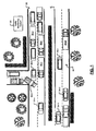
- Vehicles 20-1. 20-2, ..., and 20-N (generally identified as vehicles 20) travel on a road in a first direction generally identified at 22.
- Vehicles 24-1, 24-2, ..., and 24-M (generally identified as vehicles 24) travel on the road in a second direction generally identified at 32.
- vehicles 20-5 and 20-6 are involved in an accident, which slows the flow of traffic in the first direction 22. The accident does not slow traffic moving in the second direction 32.
- the traffic monitoring system alerts motorists of the slow traffic on the road traveling in the first direction, as well as information relating to traffic on other freeways, streets and other major thoroughfares.
- some of the vehicles 20 and 24 include global positioning systems (GPS) that include receivers that triangulate vehicle position based on signals generated by GPS satellites.
- GPS may include an integrated transmitter and/or transceiver that transmits vector and location data wirelessly to a traffic monitoring system 50, which is located remotely from the vehicles 20 and 24.
- a separate transmitter and/or transceiver may be used in conjunction with a receiver-only GPS.
- the vector data may include speed and direction data.
- the location data may include longitude and latitude information or location information using another coordinate system.
- the traffic monitoring system 50 receives the vector and location data, performs calculations on the data and transmits traffic and/or parking information back to the vehicles 20 and 24 with GPS systems with integrated transmitters and/or transceivers and/or GPS systems with separate transmitters and/or transceivers as will be described further below.
- the GPS systems of the vehicles provide visual and/or audible traffic information to allow drivers to avoid traffic bottlenecks such as the accident and/or to find parking spots.
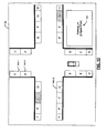
- a vehicle 60 includes a GPS 62, a wireless transceiver 64 and a display 66.
- a control module 65 that is integrated with the GPS 62 performs control functions relating to traffic and/or parking information systems.
- the GPS 62 triangulates position or location data of the vehicle 60 and calculates vector data using GPS signals generated by GPS satellites.
- the vehicle 60 selectively transmits the location and vector data wirelessly via the transceiver 64 to the remote traffic monitoring system 50.
- the transceiver 64 periodically receives traffic data from the remote traffic monitoring system 50 as will be described further below.
- the GPS systems 62 outputs traffic and other GPS-related information using the display 66.
- the transceiver 64 may be integrated with the GPS 62.
- the control module 65 may be separate from the GPS 62 as shown at 62' and 65' in FIG. 2B .
- a vehicle 60' that is similar to FIGs. 2A and 2B is shown and further comprises a vehicle-based remote service assistance system 70, which provides a connection to a main remote service assistance system and/or a service assistant.
- a vehicle-based remote service assistance system 70 provides a connection to a main remote service assistance system and/or a service assistant.
- a vehicle-based remote service assistance system 70 is OnStar ® , although other remote service assistance systems may be utilized.
- the remote service assistance system 70 and the traffic monitoring system 50 share the common transceiver 64.
- the transceiver 64 may be integrated with the GPS 62 and/or the remote service system 70.
- a vehicle 60" that is similar to FIGs. 2A and 2B is shown and further comprises an alternate remote service assistance system 70'.
- the remote service assistance system 70' utilizes a transceiver 72 that is separate from the transceiver 64 used by the GPS system 62.
- any suitable wireless systems may be employed including cellular systems, WiFi systems such as 802.11, 802.11a, 802.11b, 802.11 g, 802.11 n (which are hereby incorporated by reference), and/or other future 802.11 standards, WiMax systems such as 802.16 (which is hereby incorporated by reference) and/or any other suitable type of wireless system that allows communication over sufficient distances.
- one or both of the transceivers 64 and 72 are integrated with the GPS 62 and/or remote service system 70'.
- the control module may be integrated with or separate from the GPS and/or other system components.
- the traffic monitoring system includes a plurality of monitoring stations 100-1, 100-2, ..., and 100-X (collectively monitoring stations 100) such as the station 50 shown in FIG. 1 .
- the parking information can be provided in addition to or separate from the traffic information.
- the monitoring stations 100 include a transceiver 104.
- the monitoring stations 100 receive location and vector data from the vehicles and transmit traffic and/or parking information to the vehicles as will be described.
- the monitoring stations 100 are connected to one or more databases 110 that store traffic and/or parking information. Traffic monitoring modules or programs 112 analyze the data that is stored in the databases 110.
- the monitoring station 100-1 includes a server 120-1 and a network interface (Nl) 124-1.
- the Nl 124-1 provides a connection to the distributed communications system 114.
- the distributed communications system 114 includes the Internet, although any other type of network may be used.
- the databases 110 may also be connected to the distributed communications system 114 by servers 130 via Nl 132. Other types of interconnection include dedicated phone lines, terrestrial links, satellite links and/or other suitable links may be used.
- the main RSA system 133 may communicate with one or more of the servers 130 and/or may have all independent links via the DCS 114.
- the system may use an inquiry response technique and/or a push technique for providing parking and/or traffic information.
- a plurality of smart parking meters 138-1, 138-2, ..., and 138-P can be provided.
- the smart parking meters 138 provide an indication when the parking spot is filled or vacant.
- the smart parking meter 138 may make this decision based on a meter status signal generated by an expired module 139.
- the expired module generates the meter status signal having a spot filled state when the meter is running.
- the meter status signal has a spot vacant state when the meter expires. In other words, when the meter is expired, the smart parking meter can assume that the spot is vacant.
- the smart parking meter 138 may include a sensor 140 that senses whether a vehicle is located in a corresponding parking spot.
- the sensor outputs a radio frequency signal in a direction towards the parking space and generates the meter status signal depending on reflected signals that are received. If the reflected signals are returned in a period less than a threshold and/or have an amplitude greater than a threshold, a vehicle is in the spot. If not, the spot is vacant.
- the reflected signals need to be less than the threshold for a predetermined period (to reduce noise).
- a group of meters may include a common sensor that senses the presence of one or more vehicles in one or more parking spots of the group.
- a parking lot 142 may include a parking spot module 143 that provides a collective signal that K parking spots are available in the entire parking lot 142.
- the smart parking meters 138 and smart parking lots 142 may be connected to the traffic monitoring system in any suitable manner including network interfaces (NI) 144, wireless transmitters 146 and/or in any other suitable manner. When transmitting the information, wireless or wired connections may be used.
- NI network interfaces
- wireless transmitters 146 When transmitting the information, wireless or wired connections may be used.
- the vehicle sends vehicle vector and location data on a periodic basis.
- the data transmission may be selectively enabled while the vehicle ignition is on, the vehicle ignition is on or off, the vehicle is moving and/or using other criteria.
- Control begins with step 150.
- step 152 the vehicle sends vector and location data.
- step 154 a timer is reset.
- step 156 control determines whether a timer is up. If false, control returns to step 156. If step 156 is true, control returns to step 152.
- Control may be performed by the GPS system 62 or using any other control module in the vehicle. Alternately and/or in addition to the foregoing, the traffic monitoring system may periodically query the vehicle remotely for vector and/or location data. The vehicle responds to the query by sending the vector and/or location data.
- control begins with step 160.
- control determines whether the vehicle is located on a major thoroughfare.
- major thoroughfares may be defined to include freeways, highways and major streets.
- Major thoroughfares may exclude smaller streets, residential areas and low traffic streets to reduce the amount of data being sent. Since traffic is low on these types of roads, traffic information is not needed.
- step 162 If step 162 is false, control returns to step 162. If step 162 is true, control resets a timer in step 164.
- control determines whether a timer is up. If not, control continues with step 168 and determines whether the vehicle has a direction change that is greater than a first threshold.
- Step 170 determines whether the vehicle has incurred a speed change that is greater than a second threshold. Steps 166, 168 and 170 also tend to limit data being transmitted by the vehicle to the traffic monitoring system. One or more of these steps may be performed.
- step 180 control determines whether the vehicle ignition transitions from on to off. If true, control determines whether the vehicle is located in a public parking area in step 184. This step may be performed by the vehicle alone and/or by the vehicle transmitting location information to the traffic monitoring system and receiving a response indicating whether the location is a parking spot in a public parking area. If step 184 is true, the vehicle sends a park indicator and location data in step 186. Control continues from step 186 to step 182. If step 184 is false, control returns to step 182. Therefore, the traffic monitoring system receives data related to parked vehicles.
- step 182 control continues with step 190 and control determines whether the vehicle ignition transitions from off to on and the vehicle is moved. When the ignition turns on, it is likely that the vehicle may exit the parking space. If step 190 is true, control sends vehicle vector and location data to the traffic monitoring system in step 192 and control returns to step 182. If step 190 is false, control also continues with step 182.
- the traffic monitoring system uses the vehicle parking and vehicle leaving data to provide parking information to other vehicles.
- step 200 control determines whether the vehicle ignition transitions from on to off. If step 202 is true, control sends vehicle park indicator and location data in step 204 and as described above. If step 202 is false, control continues with step 206. In step 206, control determines whether the vehicle ignition transitions from off to on and the vehicle is moved. If true, control sends vehicle vector and location data. If step 206 is false, control returns to step 202.
- control begins with step 220.
- control receives data from the vehicles.
- control estimates average speeds on selected portions of thoroughfares based on data from one or more vehicles.
- the traffic monitoring system may estimate average speeds for predetermined distances or increments. The increments may vary based on road type, conditions or calculated speeds. For example, as the difference between the average speeds and the posted speeds differ, the predetermined increment may be reduced in length.
- Traffic information is transmitted to the vehicles based upon calculations made on the collected vehicle data. The traffic information may be pushed to the vehicles and/or an inquiry/response technique may be used in step 230. Control ends in step 232.
- parking data may also be transmitted to the vehicles using a push technique and/or an inquiry/response technique.
- control begins with step 250.
- control determines whether a vehicle is stopped in a public parking spot. The decision may be based on location and vector data samples and/or based on a parking indicator and location data. The determination that the parking spot is a public spot is based on the location data. If true, control indicates that the corresponding public parking spot is filled in step 254.
- Control continues from steps 252 and 254 with step 256.
- step 256 control determines whether a vehicle transitions from parking to moving. If step 256 is true, control starts a timer in step 258.
- step 260 control indicates that a vehicle is leaving a public parking space. The timer is used to limit the amount of time that the parking space is identified as "vehicle leaving”.
- step 260 control determines whether a timer for a vehicle is up. If step 262 is true, control changes a status of the parking space to unknown in step 264. Control continues from steps 262 and 264 with step 252.
- Control begins with step 280.
- control receives data from vehicles.
- control determines an average speed on a thoroughfare portion that the vehicle is traveling on.
- control determines whether the speed of each vehicle is less than a first speed threshold and the average speed on a thoroughfare is greater than a second speed threshold.
- step 288 control triggers an inquiry via the remote service assistance system in step 290.
- the traffic monitoring system notifies the main remote service assistance system to have a service assistant contact the driver of the vehicle.
- the service assistant can determine whether or not there is a problem such as an accident or other operational problem and contact emergency personnel, roadside assistance and/or other assistance as needed.
- step 294 control determines whether there are additional vehicles to evaluate. If step 294 is true, control returns to step 284. If step 294 is false, control returns to step 282.
- FIG. 11 a display illustrating vehicle speeds on thoroughfares 298-1, 298-2, ... and 298-Z is shown.
- the display 66 associated with the GPS system at 62 is shown.
- Visual elements generally identified by 300-1, 300-2, ..., and 300-Y are provided on the map.
- the visual elements indicate bottlenecks and/or other traffic on the main thoroughfares. Any suitable visual indication may be used to identify problems. For example, color, cross-hatching, shading, shapes, blinking and/or other techniques may be used to identify high traffic zones, low speed zones, construction zone, and/or accident zones.
- visual element 300-3 may be rendered in red and flashing to signify an accident.
- Speeds on the thoroughfare also provide an indication of a problem (e.g. the speeds decrease as the distance to the accident 300-3 decreases).
- the display 60 of the GPS 62 can be used to identify available parking spaces 340-1, 340-2, ..., and 340-G in a selected area.
- the traffic monitoring system may provide filled (F), leaving (L), open (O) and/or unknown (U) status data for parking spaces in a selected area. These indicators may be designated using any suitable visual indication.
- the filled indicator is used when a vehicle with the GPS system parks in the spot and the traffic monitoring system does not receive data indicating that the vehicle has moved.
- the unknown indicator is used when there is no information concerning the space and/or after a predetermined amount of time after a vehicle with a GPS system leaves a parking spot.
- a leaving indicator is used within a predetermined time after a vehicle with a GPS system leaves a parking spot.
- the leaving indicator may also be triggered when a vehicle with a GPS system starts its engine after a dwell period.
- the open status is used when the space is open. In some implementations, the status is provided by smart parking meters 138. Spaces in smart parking lots 142 may also be shown at 342.
- Control begins in step 300.
- the traffic monitoring system receives data from vehicles.
- the traffic monitoring system compares locations of the vehicles at the same time. Based on the location and time, the traffic monitoring system can determine whether an accident may have occurred. If the vehicles have substantially the same location at the same time, the traffic monitoring system may query the users to determine whether an accident has occurred in step 308. In other words, if two vehicles provide their location at a particular time and the locations conflict, the traffic monitoring system may assume that there is a possibiiity that an accident occurred and take action via the remote service assistance system.
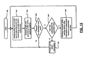
- Control begins in step 320.
- step 324 fees are charged for subscription services. The fees can be based on the level of service that is requested.
- step 328 data is collected from at least one of subscribing and non-subscribing vehicles and/or from smart parking meters and/or lots. In some implementations, data from other subscriber systems may be used.
- step 332 data is analyzed and traffic, parking and other information is generated.
- step 334 selected traffic, parking and/or other information is sent to subscribers based on subscribed services of the user. For example, some users may pay a subscription fee to receive traffic information but not parking information. Other subscribers may receive either parking information only or traffic and parking information.
- the subscriber levels may also be differentiated based on geography, time of day and/or using other criteria. Control ends in step 338.
- Control begins in step 340.
- step 342 data is collected from at least one of subscribing and non-subscribing vehicles and/or from smart parking meters and/or lots.
- step 344 data that is collected is analyzed and traffic, parking and other information is updated.
- step 346 control determines whether a request for information is received. Alternately, the information can be pushed to the user based on the subscription of the user. If step 346 is false, control returns to step 342. If step 346 is true, control determines whether the user has a subscription for the requested information. If false, control prompts the user to obtain a subscription.
- the subscriptions can be on a periodic basis, a pay-per-use basis or on any other basis. If step 348 is true, the requested information is sent to the subscriber.
- encryption and/or other techniques may be used to prevent fraudulent access to the traffic and/or parking information.
Description
- The present invention relates to traffic monitoring systems, and more particularly to global positioning system (GPS)-based traffic monitoring systems for vehicles.
- Global positioning systems (GPS) for vehicles typically include a receiver that triangulates vehicle position using beacons generated by GPS satellites. These systems also typically include a map database that is used to provide the location of the vehicle on a map, driving directions, the location of restaurants and other businesses, and/or other information. As cities become more populated, it has become more difficult to travel without incurring delays due to traffic congestion, accidents, construction and/or other problems. Finding parking in congested cities can also be difficult.
-
US 6, 426, 709 B1 refers to a method for transmitting local data and measurement data from a terminal, including a telematic terminal, to a central traffic control unit. A reduction in a telecommunication costs in the transmission of extensive data from a telematic terminal unit in a vehicle to a central station is made possible by a method for the transmission of location data indicating the location of the terminal unit in a traffic network at a point in time and of measurement data indicating other characteristics of the traffic network at a location and/or at a time to the central traffic station, which location data and measurement data are detected by the terminal unit, particularly a telematic terminal unit for a vehicle. At least some of the data records transmitted from the terminal unit to the central traffic station contain only location data and some of the data records transmitted from the terminal unit to the central traffic station contain measurement data. -
EP 0 755 039 A2 refers to a method and system for prognosing of traffic flow. Prediction of road traffic conditions are performed based on random sampling. A sampling system has a number of vehicle activity sensors that are distributed over a wide geographical range and can be in mobile or fixed installations. These sensors communicate with the receivers of a traffic condition computer. The computer is in communication with a number of vehicles that are to be directed through the road system. The random sampling of the traffic conditions allows a prediction to be made of conditions and allows suitable routes to be established. -
US 2004/0246147 A1 refers to real time vehicular routing and traffic guidance system. A system is described that incorporates at least one wireless data receiver, capable of receiving from a plurality of participating transmitters, for example GPS enabled cell phones, such data as is required for determining the transmitter identification code, a sign on code, an optional routing code, describing a selected matrix of preferred and alternative routes and the location of the transmitter. - It is the object of the present invention to provide an improved traffic information system having the ability to recognize a possible problem of a vehicle.
- This object is solved by the subject matter of the independent claims.
- Preferred embodiments are defined by the dependent claims.
- It is an aspect of the present invention to provide a traffic monitoring system (50) that comprises a traffic information system in a plurality of vehicles, wherein the traffic information system comprises a global positioning system (62, 62'), GPS, for selectively generating location and vector data; a transmitter; and a control module (65, 65') for receiving the location and vector data and for wirelessly transmitting the location and vector data by using the transmitter; a memory (110) for storing traffic data; and a traffic monitoring module (112) adapted for collecting the location and vector data for the plurality of vehicles (20, 24), when the vehicles are travelling on a first set of predetermined roads; storing the location and vector data in the memory (110); analyzing the location and vector data; and generating traffic reports for the first set of predetermined roads based on the analyzed location and vector data; the traffic monitoring module (112) is further adapted for identifying vehicles having operational problems by comparing a speed of each vehicle on a first road with a first speed threshold, and by comparing an average traffic speed on the first road with a second speed threshold; and selectively triggering a remote service assistance system (133) to contact a driver of a vehicle having an operational problem if the speed of the vehicle is less than the first speed threshold and the average traffic speed is greater than the second speed threshold.
- It is another aspect of the present invention to provide a method for providing traffic information that comprises the steps of receiving location and vector data from a plurality of vehicles travelling on a first set of roads; analyzing the location and vector data; generating traffic reports based on the location and vector data; diagnosing a possible problem with a first vehicle using the location and vector data by comparing (288) a speed of one of the vehicles on a first road with a first speed threshold and comparing an average traffic speed on the first road with a second speed threshold; and triggering a remote service assistance system (133) to contact a driver of the first vehicle, when the location and vector data indicate a possible problem based on the comparison.
- According to one aspect of the present invention, a traffic information system for a vehicle comprises a transmitter and a global positioning system (GPS) associated with the vehicle that selectively generates location and vector data. A control module receives the location and vector data and wirelessly transmits the location and vector data using the transmitter when the vehicle is traveling on a first set of predetermined roads. According to an example useful for better understanding the present invention, the control module does not transmit the location and vector data when the vehicle is traveling on a second set of predetermined roads. In another aspect of the present invention, a receiver communicates with the control module and wirelessly receives traffic reports from a remote traffic monitoring system. The traffic reports include traffic speed information for traffic traveling on at least one road of the first set of predetermined roads. A service assistance system communicates with the control module and wirelessly communicates with a remote service assistance system.
- In still another aspect of the present invention, the remote traffic monitoring system receives the vector and location data and compares a speed of the vehicle on a first road to a first threshold and to an average traffic speed on the first road and selectively triggers contact with the vehicle using the service assistance system and the remote service assistance system. According to another example useful for better understanding the present invention,the traffic reports include parking status information for public parking spots. The parking status information for the public parking spots includes at least one status type selected from a group consisting of leaving, filled, open and unknown.
- In yet another aspect of the present invention, the control module transmits the vector and location data on a periodic basis. The control module monitors changes in direction of the vehicle and transmits the vector and location data when the vehicle changes direction greater than a direction change threshold. The control module monitors changes in speed of the vehicle and transmits the vector and location data when the vehicle speed change is greater than a speed change threshold.
- In a further example, the control module selectively transmits parking indication and location data using the transmitter when the vehicle ignition is turned off. The control module selectively transmits parking indication and location data using the transmitter when the vehicle ignition is turned off and the vehicle is parked in a public parking spot. The control module selectively transmits vector and location data using the transmitter when the vehicle leaves the public parking spot.
- In yet another example, the control module selectively generates location and parking indication data when an engine of the vehicle is turned off and selectively transmits the location and parking indication data using the transmitter. A parking monitoring system located remotely from the vehicle receives the location and parking indication data from the vehicle and a plurality of other vehicles, generates parking status reports, and selectively transmits the parking status reports to the vehicle.
- In still another example, a parking lot module associated with a parking lot identifies available parking spots in the parking lot and a parking lot transmitter transmits parking lot data related to the available parking spots to the parking monitoring system. A parking spot module associated with a parking spot identifies a filled status of the parking spot and a parking spot transmitter transmits parking spot data based on the filled status to the parking monitoring system.
- In an additional example, the parking status report is based in part on the parking lot data. The parking report is based in part on the parking spot data. The parking status reports include parking spot information related to parking spots within a predetermined distance of at least one vehicle. The parking spot information includes a parking status for parking spaces on at least one road. The parking status includes at least one selected from the group consisting of vacant, filled, unknown, and leaving. According to another aspect of the present invention, the control module is integrated with the GPS.
- In still another aspect of the present invention, a method is provided for operating a traffic information system for a vehicle comprises selectively generating location and vector data using a global positioning system associated with a vehicle, wirelessly transmitting the location and vector data when the vehicle is traveling on a first set of predetermined roads and not transmitting the location and vector data when the vehicle is traveling on a second set of roads.
- In still a further aspect of the present invention, the method includes wirelessly receiving traffic reports at the vehicle from a remote traffic monitoring system. The traffic reports include traffic speed information for traffic traveling on at least one of the first set of predetermined roads. The method includes comparing a speed of the vehicle on a first road to a first threshold and to an average traffic speed on the first road and selectively triggering contact with the vehicle using a remote service assistance system based on the comparison.
- In yet a further example, the traffic reports include parking status information for public parking spots. The parking status information for a parking spot includes at least one status type selected from a group consisting of leaving, filled, open and unknown.
- In still another aspect of the present invention, the method comprises transmitting the vector and location data on a periodic basis. The method comprises monitoring changes in direction of the vehicle and transmitting the vector and location data when the vehicle changes direction greater than a direction change threshold.
- In yet another aspect of the present invention, the method includes monitoring changes in speed of the vehicle and transmitting the vector and location data when the vehicle speed change is greater than a speed change threshold. The method comprises selectively transmitting parking indication and location data when the vehicle ignition is turned off. According to another example useful for better understanding the present invention, the method further comprises selectively transmitting parking indication and location data when the vehicle ignition is turned off and the vehicle is parked in a public parking spot.
- In a further example, the method comprises transmitting vector and location data when the vehicle leaves the public parking spot. The method comprises selectively generating location and parking indication data when an engine of the vehicle is turned off and selectively transmitting the location and parking indication data.
- In yet another example, the method comprises receiving the location and parking indication data from the vehicle and a plurality of other vehicles, generating parking status reports and selectively transmitting the parking status reports to the vehicle. The method further comprises identifying available parking spots in a parking lot, and wirelessly transmitting parking lot data related to the available parking spots to a remote parking monitoring system.
- In still an additional example, the method includes identifying a filled status of a parking spot and transmitting parking spot data based on the filled status to a remote parking monitoring system. The method includes the parking status report based in part on the parking lot data. The method comprises the parking reports based in part on the parking spot data. The method includes parking spot information related to parking spots within a predetermined distance of at least one vehicle. The method includes the parking spot information includes a parking status for a parking spot. The parking status includes at least one selected from the group consisting of vacant, filled, unknown, and leaving.
- In still a further aspect of the present invention, a traffic information system for a vehicle comprises global positioning system (GPS) means associated with the vehicle for selectively generating location and vector data, transmitting means for wirelessly transmitting data, and control means for receiving the location and vector data and for wirelessly transmitting the location and vector data using the transmitting means when the vehicle is traveling on a first set of predetermined roads and for not transmitting the location and vector data when the vehicle is traveling on a second set of roads.
- In still a further aspect of the present invention, the traffic information system comprises receiving means for wirelessly receiving traffic reports from a remote traffic monitoring means for monitoring traffic. The traffic reports include traffic speed information for traffic traveling on at least one of the first set of predetermined roads. Remote service assistance means communicates with the control means and wirelessly communicates with a remote service assistance system. The remote traffic monitoring means compares a speed of the vehicle on a first road to a first threshold and to an average traffic speed on the first road and selectively triggers contact with the vehicle using the remote service assistance system.
- In yet another example for better understanding the present invention, the traffic reports include parking status information for public parking spots. The parking status information for a parking spot includes at least one type selected from a group consisting of leaving, filled, open and unknown.
- In still other aspects of the present invention, the control means transmits the vector and location data on a periodic basis. The control means monitors changes in direction of the vehicle and transmits the vector and location data using the transmitting means when the vehicle changes direction greater than a direction change threshold. The control means monitors changes in speed of the vehicle and the transmitting means transmits the vector and location data using the transmitting means when the vehicle speed change is greater than a speed change threshold. According to another example useful for better understanding the present invention, the control means selectively transmits parking indication and location data using the transmitting means when the vehicle ignition is turned off.
- In yet another example, the control means selectively transmits parking indication and location data using the transmitting means when the vehicle ignition is turned off and the vehicle is parked in a public parking spot. The control means selectively transmits vector and location data using the transmitting means when the vehicle leaves the public parking spot. The control means selectively generates location and parking indication data when an engine of the vehicle Is turned off and selectively transmits the location and parking indication data using the transmitting means.
- In still a further example, the traffic information further comprises parking monitoring means for remotely monitoring parking, for receiving the location and parking indication data from the vehicle and a plurality of other vehicles, for generating parking status reports, and for selectively transmitting the parking status reports to the vehicle.
- In yet an additional example, the system further comprises parking lot means associated with a parking lot for identifying available parking spots in the parking lot and parking lot transmitting means for transmitting parking lot data related to the available parking spots to the parking monitoring means. Parking spot means associated with a parking spot for identifying a filled status of the parking spot and parking spot transmitting means for transmitting parking spot data based on the filled status to the parking monitoring means.
- In still another example, the parking status report is based in part on the parking lot data. The parking report is based in part on the parking spot data. The parking status reports include parking spot information related to parking spots within a predetermined distance of the at least one vehicle. The parking status includes at least one status type selected from the group consisting of vacant, filled, unknown, and leaving.
- In still a further example, a system comprises a vehicle that includes a global positioning system (GPS) that selectively generates location and parking indication data when the vehicle is parked. A transceiver selectively wirelessly transmits data. A control module receives the location and parking indication data from the GPS and transmits the location and parking indication data using the transmitter. A parking monitoring system located remotely from the vehicle receives the location and parking indication data from the vehicle and a plurality of other vehicles, generates parking status reports based on the location and parking indication data, and selectively transmits the parking status reports to the vehicle.
- In another example, a parking lot module associated with a parking lot identifies an available number of parking spots in the parking lot. A parking lot transmitter transmits parking lot data related to the available number of parking spots to the parking monitoring system. A parking spot module associated with a parking spot identifies a filled status of the parking spot. A parking spot transmitter transmits parking spot data based on the filled status to the parking monitoring system.
- In still another example, the parking status reports are based in part on the parking lot data. The parking reports are based in part on the parking spot data. The parking status report for the vehicle includes parking information related to parking spots within a predetermined distance of the vehicle.
- In yet a further example, the parking reports include a parking status for parking spaces on predetermined types of roads within a predetermined distance of at least one of the vehicle and another location selected by a user of the GPS. The parking status includes at least one status type selected from the group consisting of vacant, filled, unknown, and leaving. The control module selectively receives location and vector data from the GPS when the vehicle is not parked. The transceiver transmits the location and vector data.
- In an additional aspect of the present invention, the control module transmits the location and vector data using the transceiver when the vehicle is traveling on a first set of predetermined roads and does not transmit the location and vector data when the vehicle is traveling on a second set of roads. A remote traffic monitoring system receives the vector and location data from the vehicle and other vehicles and generates traffic reports based thereon. The traffic reports include traffic speed information for traffic on at least one road of the first set of predetermined roads.
- In yet another aspect of the present invention, a service assistance system communicates with the control module and wirelessly communicates with a remote service assistance system. The remote traffic monitoring system compares a speed of the vehicle on a first road to a first threshold and to an average traffic speed on the first road and selectively triggers contact with the vehicle using the remote service assistance system.
- In still another aspect of the present invention, the control module generates the vector and location data on a periodic basis using the transceiver. The control module monitors changes in direction of the vehicle and transmits the vector and location data using the transceiver when the vehicle changes direction greater than a direction change threshold. The control module monitors changes in speed of the vehicle and transmits the vector and location data using the transceiver when the vehicle speed change is greater than a speed change threshold.
- In yet another example, the control module selectively transmits parking indication and location data using the transceiver when the vehicle ignition is turned off. The control module selectively transmits parking indication and location data using the transceiver when the vehicle ignition is turned off and the vehicle is parked in a public parking spot. The control module selectively transmits parking indication and location data using the transceiver when the vehicle leaves a public parking spot.
- In still a further example, a method comprises: selectively generating location and parking indication data when a vehicle is parked; selectively wirelessly transmitting the location and parking indication data; receiving the location and parking indication data from the vehicle and a plurality of other vehicles; generating parking status reports based on the location and parking data; and selectively transmitting the parking status reports to the vehicle.
- In yet a further example, the method includes identifying an available number of parking spots in a parking lot and transmitting parking lot data related to the available number of parking spots to a remote parking monitoring system.
- In still another example, the method includes identifying a filled status of a parking spot and transmitting parking spot data based on the filled status to a remote parking monitoring system. The parking status reports are based in part on the parking lot data. The parking reports are based in part on the parking spot data. The parking status reports for the vehicle include parking information related to parking spots within a predetermined distance of the vehicle.
- In yet an additional example, the parking information includes a parking status for parking spaces on predetermined types of roads within a predetermined distance of at least one of the vehicle and another location selected by a user. The parking status includes at least one status type selected from the group consisting of vacant, filled, unknown, and leaving.
- In still another example, the method includes selectively generating location and vector data when the vehicle is not parked and transmitting the location and vector data. According to another aspect of the present invention, the method further includes transmitting the location and vector data when the vehicle is traveling on a first set of predetermined roads and not transmitting the location and vector data when the vehicle is traveling on a second set of predetermined roads.
- In yet another aspect of the present invention, the method includes wirelessly receiving traffic reports from a remote traffic monitoring system. The traffic reports include traffic speed information for traffic on at least one road of the first set of predetermined roads.
- In a further aspect of the present invention, the method comprises comparing a speed of the vehicle on a first road to a first threshold and to an average traffic speed on the first road and selectively triggering contact with the vehicle using a remote service assistance system. The method includes transmitting the vector and location data on a periodic basis.
- In still another aspect of the present invention, the method includes monitoring changes in direction of the vehicle and transmitting the vector and location data when the vehicle changes direction greater than a direction change threshold. The method further includes monitoring changes in speed of the vehicle and transmitting the vector and location data when the vehicle speed change is greater than a speed change threshold.
- In yet another example, the method includes selectively transmitting parking indication and location data when the vehicle ignition is turned off. The method includes transmitting parking indication and location data when the vehicle ignition is turned off and the vehicle is parked in a public parking spot and selectively transmitting parking indication and location data when the vehicle leaves a public parking spot.
- In still a further example, a system comprises a vehicle including that includes global positioning system (GPS) means for selectively generating location and parking indication data when the vehicle is parked, transceiver means for selectively wirelessly transmitting data, and control means for receiving the location and parking indication data from the GPS means and for transmitting the location and parking data using the transceiver means. Parking monitoring means located remotely from the vehicles receives the location and parking indication data from the vehicle and a plurality of other vehicles, generates parking status reports based on the location and parking indication data, and selectively transmits the parking status reports to the vehicle.
- In an additional example, parking lot means associated with a parking lot identifies an available number of parking spots in the parking lot. Parking lot transmitting means transmits parking lot data related to the available number of parking spots to the parking monitoring means. Parking spot means associated with a parking spot identifies a filled status of the parking spot. Parking spot transmitting means transmits parking spot data based on the filled status to the parking monitoring means.
- In yet a further example, the parking reports are based in part on the parking spot data. The parking status reports for the vehicle include parking information related to parking spots within a predetermined distance of the vehicle.
- In still another example, the parking information includes a parking status for parking spaces on predetermined types of roads within a predetermined distance of at least one of the vehicle and another location selected by a user of the GPS means. The parking status includes at least one selected from the group consisting of vacant, filled, unknown, and leaving.
- In yet another example, the control means selectively generates location and vector data when the vehicle is not parked and the transceiver means transmits the location and vector data. The control means transmits the location and vector data using the transceiver means when the vehicle is traveling on a first set of predetermined roads and does not transmit the location and vector data when the vehicle is traveling on a second set of roads. According to another aspect of the present invention, the system further comprises the remote traffic monitoring means for remotely monitoring traffic. Wherein the transceiver means wirelessly receives traffic reports from the remote traffic monitoring means. The traffic reports include traffic speed information for traffic on at least one of the first set of predetermined roads.
- In still a further aspect of the present invention, the system comprises remote service assistance means for interfacing with a remote service assistance system. The remote traffic monitoring means compares a speed of the vehicle on a first road to a first threshold and to an average traffic speed on the first road and selectively triggers contact with the vehicle using the remote service assistance system. The control means transmits the vector and location data on a periodic basis.
- In yet another example, the control means monitors changes in direction of the vehicle and transmits the vector and location data using the transceiving means when the vehicle changes direction greater than a direction change threshold. The control means monitors changes in speed of the vehicle and transmits the vector and location data using the transceiving means when the vehicle speed change is greater than a speed change threshold. According to another example useful for better understanding the present invention, the control means selectively transmits parking indication and location data using the transceiving means when the vehicle ignition is turned off.
- In still another aspect of the present invention, the control means selectively transmits parking indication and location data using the transceiving means when the vehicle ignition is turned off and the vehicle is parked in a public parking spot. The transceiver means selectively transmits parking indication and location data when the vehicle leaves a public parking spot
- In still a further aspect of the present invention, a traffic monitoring system comprises memory that stores traffic data. A traffic monitoring module collects vector and location data for a plurality of vehicles when the vehicles are traveling on a first set of predetermined roads and does not collect the vector and location data when the vehicles are traveling on a second set of predetermined roads. The traffic monitoring module stores the vector and location data in the memory, analyzes vector and location data, and generates traffic reports for the first set of predetermined roads based on the analyzed vector and location data.
- In a further aspect of the present invention, the traffic monitoring module receives requests for the traffic reports from at least one vehicle, confirms that the vehicle is a subscriber for the traffic reports, and transmits the traffic reports to the vehicle if the vehicle is a subscriber. According to another example useful for better understanding the present invention, the traffic monitoring module receives parking indication and location data for the vehicles and stores the parking indication and location data in the memory. The traffic monitoring module receives the parking indication and location data only for the vehicles that are parked in public parking spots. The traffic monitoring module generates parking reports for the subscribers based on the parking indication and location data.
- In still another example, the traffic monitoring module receives parking lot data for parking lots. The parking lot data indicates a number of vacant parking spots for a respective one of the parking lots. The traffic monitoring module receives parking spot data for parking spots. The parking spot data indicates a filled status of a respective one of the parking spots.
- In still a further aspect of the present invention, a traffic monitoring system comprises storing means for storing traffic data. Traffic monitoring means collects vector and location data for a plurality of vehicles when the vehicles are traveling on a first set of predetermined roads and does not collect the vector and location data when the vehicles are traveling on a second set of predetermined roads. The traffic monitoring means stores the vector and location data in the storing means, analyzes the vector and location data, and generates traffic reports for the first set of predetermined roads based on the analyzed vector and location data.
- In yet another aspect of the present invention, the traffic monitoring means receives requests for the traffic reports from at least one vehicle, confirms that the vehicle is a subscriber for the traffic reports, and transmits the traffic reports to the vehicle if the vehicle is a subscriber. According to another example, the traffic monitoring means receives parking indication and location data for the vehicles, and stores the parking indication and location data in the storing means. The traffic monitoring means receives the parking indication and location data only for the vehicles that are parked in public parking spots.
- In still a further example, the traffic monitoring means generates parking reports for the subscribers based on the parking indication and location data. The traffic monitoring means receives parking lot data for parking lots. The parking lot data indicates a number of vacant parking spots for a respective one of the parking lots. The traffic monitoring means receives parking spot data for parking spots. The parking spot data indicates a filled status of a respective one of the parking spots.
- In still another aspect of the present invention, a method is provided for operating a traffic monitoring system comprises storing traffic data collecting vector and location data for a plurality of vehicles when the vehicles are traveling on a first set of predetermined roads and not collecting the vector and location data when the vehicles are traveling on a second set of predetermined roads, storing the vector and location data, analyzing the vector and location data, and generating traffic reports for the first set of predetermined roads based on the analyzed vector and location data.
- In another aspect of the present invention, the method comprises receiving requests for the traffic reports from at least one vehicle confirming that the vehicle is a subscriber for the traffic reports, and transmitting the traffic reports to the vehicle if the vehicle is a subscriber. According to another example useful for better understanding the present invention, the method includes receiving parking indication and location data for the vehicle and storing the parking indication and location data. The method further comprises receiving the parking indication and location data for the vehicles that are parked in public parking spots.
- In yet a further example, the method comprises generating parking reports for the subscribers based on the parking indication and location data. The method comprises receiving parking lot data for parking lots. The parking lot data indicates a number of vacant parking spots for a respective one of the parking lots. The method further comprises receiving parking spot data for parking spots. The parking spot data indicates a filled status of a respective one of the parking spots.
- In yet another aspect of the present invention, a method is provided for providing traffic information comprises maintaining a list of vehicles that are subscribers of the traffic information, receiving vector and location data from a plurality of vehicles traveling on a first set of roads, analyzing the vector and location data, generating traffic reports based on the vector and location data, and transmitting the traffic reports to the vehicles that are subscribers of the traffic information.
- In another aspect of the present invention, the method comprises at least one of receiving requests for the traffic reports from the vehicles and transmitting the traffic reports to subscribers of the traffic reports, and pushing the traffic reports to the subscribers. The method comprises billing the subscribers for the traffic information. The method comprises wirelessly transmitting the location and vector data when one of the plurality of vehicles is traveling on a first set of predetermined roads, and not transmitting the location and vector data when the one of the plurality of vehicles is traveling on a second set of predetermined roads.
- In still another aspect of the present invention, the traffic report includes traffic speed information for traffic on at least one road of the first set of predetermined roads. The method further comprises diagnosing a possible problem with a first vehicle using said vector and location data, and using a remote service assistance system to contact said first vehicle when said vector and location data indicates said possible problem.
- In yet another aspect of the present invention the method comprises comparing a speed of one of the vehicles on a first road to a first threshold and to an average traffic speed on the first road, and selectively contacting the vehicle using a remote service assistance system based on the comparison. According to another example useful for better understanding the present invention, the method comprises receiving parking data from the vehicles, and generating parking status information for public parking spots based on the parking data. The parking status information includes at least one status type selected from a group consisting of leaving, filled, open and unknown.
- In still another aspect of the present invention, the vehicles transmit the vector and location data on a periodic basis. The method comprises monitoring changes in direction of the vehicle, and transmitting the vector and location data when the vehicle changes direction greater than a direction change threshold. The method comprises monitoring changes in speed of the vehicle, and transmitting the vector and location data when the vehicle speed change is greater than a speed change threshold.
- In yet another example, the method further comprises selectively transmitting parking Indication and location data when one of the vehicles parks in a public parking spot. The method comprises transmitting vector and location data when the vehicle leaves the public parking spot. The method comprises selectively generating location and parking indication data when an engine of the vehicle is turned off, and selectively transmitting the location and parking indication data.
- In yet a further example, the method comprises maintaining a list of vehicles that are subscribers of parking status reports, receiving location and parking indication data from the vehicles, generating the parking status reports, and selectively transmitting the parking status reports to the vehicles that are subscribers. The parking status report for a respective one of the vehicles includes parking information related to parking spots within a predetermined distance of the respective one of the vehicles.
- In still another aspect of the present invention, the method comprises monitoring when the vehicle transitions from one road to another road, and transmitting the vector and location data when the transitions occur.
- In yet another example, a method is provided for providing parking information comprises maintaining a list of vehicles that are subscribers of the parking information, receiving parking indication and location data from a plurality of vehicles when the vehicles are parked in public parking spots, generating parking reports based on the parking indication and location data, and transmitting the parking reports to the vehicles that are subscribers of the parking information.
- In still another example, the method comprises receiving requests for the parking reports from the vehicles and transmitting the parking reports to subscribers of the parking reports, and pushing the parking reports to the subscribers. The method comprises billing the subscribers for the parking information.
- In yet another examples, the method comprises wirelessly transmitting the parking indication and location data when one of the plurality of vehicles parks in a public parking spot, and not transmitting the parking indication and location data when the one of the plurality of vehicles parks in a non-public parking spot. Parking status information for parking spots includes at least one status type that is selected from a group consisting of leaving, filled, open and unknown.
- In still other examples, the method further comprises transmitting vector and location data when the vehicle leaves the public parking spot. The method comprises selectively generating location and parking indication data when an engine of the vehicle is turned off, and selectively transmitting the location and parking indication data. The method further comprises maintaining a list of vehicles that are subscribers of parking status reports. The parking status report for a respective one of the vehicles includes parking information related to parking spots within a predetermined distance of the at least one vehicle.
- Further areas of applicability of the present invention will become apparent from the detailed description provided hereinafter. It should be understood that the detailed description and specific examples, while indicating the preferred embodiment of the invention, are intended for purposes of illustration only and are not intended to limit the scope of the invention.
- The present invention will become more fully understood from the detailed description and the accompanying drawings, wherein:
-
FIG. 1 illustrates an exemplary traffic monitoring system that monitors vehicle traffic according to the present invention; -
FIGs. 2A and 2B are functional block diagrams of exemplary vehicles including a GPS, a transceiver, a control module and a display; -
FIG. 3A is a functional block diagram of the exemplary vehicle ofFIG. 2A with a remote service assistance (RSA) system; -
FIG. 3B is a functional block diagram of the exemplary vehicle ofFIG. 2A with an alternate RSA system; -
FIG. 4 is a functional block diagram of portions of an exemplary traffic monitoring system; -
FIG. 5 is a flow chart illustrating exemplary steps performed by a vehicle for transmitting data; -
FIG. 6 is a flow chart illustrating first alternate exemplary steps performed by a vehicle for transmitting data; -
FIG. 7A is a flow chart illustrating exemplary steps performed by the traffic monitoring system for transmitting parking-related data; -
FIG. 7B is a flow chart illustrating alternate exemplary steps performed by the traffic monitoring system for transmitting parking-related data; -
FIG. 8 is a flow chart illustrating steps performed by the traffic monitoring system for receiving and processing traffic and parking data; -
FIG. 9 illustrates steps performed by the traffic monitoring system for monitoring parking; -
FIG. 10 illustrates steps performed by the traffic monitoring system and the RSA system for identifying vehicles having operational problems; -
FIG. 11 illustrates an exemplary map display with average vehicle speeds on roads, accidents, construction and/or other items; -
FIG. 12 illustrates an exemplary display of available parking in the vicinity of the vehicle; -
FIG. 13 illustrates steps performed by the traffic monitoring system to identify possible vehicle accidents; -
FIG. 14 illustrates steps performed by an exemplary traffic and/or parking information subscriber system; and -
FIG. 15 illustrates steps performed by another exemplary traffic and/or parking information subscriber system. - The following description of the preferred embodiment(s) is merely exemplary in nature and is in no way intended to limit the invention, its application, or uses. For purposes of clarity, the same reference numbers will be used in the drawings to identify similar elements.
- Referring now to
FIG. 1 , an exemplary traffic monitoring system that monitors vehicle traffic according to the present invention is shown. Vehicles 20-1. 20-2, ..., and 20-N (generally identified as vehicles 20) travel on a road in a first direction generally identified at 22. Vehicles 24-1, 24-2, ..., and 24-M (generally identified as vehicles 24) travel on the road in a second direction generally identified at 32. For example, vehicles 20-5 and 20-6 are involved in an accident, which slows the flow of traffic in thefirst direction 22. The accident does not slow traffic moving in thesecond direction 32. The traffic monitoring system alerts motorists of the slow traffic on the road traveling in the first direction, as well as information relating to traffic on other freeways, streets and other major thoroughfares. - According to the present invention, some of the
vehicles traffic monitoring system 50, which is located remotely from thevehicles traffic monitoring system 50 receives the vector and location data, performs calculations on the data and transmits traffic and/or parking information back to thevehicles - Referring now to
FIGs. 2A, 2B, 3A and 3B , several exemplary vehicle configurations are shown. While specific examples are shown, other configurations may be used. InFIG. 2A , avehicle 60 includes aGPS 62, awireless transceiver 64 and adisplay 66. Acontrol module 65 that is integrated with theGPS 62 performs control functions relating to traffic and/or parking information systems. TheGPS 62 triangulates position or location data of thevehicle 60 and calculates vector data using GPS signals generated by GPS satellites. Thevehicle 60 selectively transmits the location and vector data wirelessly via thetransceiver 64 to the remotetraffic monitoring system 50. Thetransceiver 64 periodically receives traffic data from the remotetraffic monitoring system 50 as will be described further below. TheGPS systems 62 outputs traffic and other GPS-related information using thedisplay 66. In some implementations, thetransceiver 64 may be integrated with theGPS 62. As can be appreciated, thecontrol module 65 may be separate from theGPS 62 as shown at 62' and 65' inFIG. 2B . - In
FIG. 3A , a vehicle 60' that is similar toFIGs. 2A and 2B is shown and further comprises a vehicle-based remoteservice assistance system 70, which provides a connection to a main remote service assistance system and/or a service assistant. For example, one suitable remoteservice assistance system 70 is OnStar®, although other remote service assistance systems may be utilized. InFIG. 3A , the remoteservice assistance system 70 and thetraffic monitoring system 50 share thecommon transceiver 64. In some implementations, thetransceiver 64 may be integrated with theGPS 62 and/or theremote service system 70. - In
FIG. 3B , avehicle 60" that is similar toFIGs. 2A and 2B is shown and further comprises an alternate remote service assistance system 70'. InFIG. 3B , the remote service assistance system 70' utilizes atransceiver 72 that is separate from thetransceiver 64 used by theGPS system 62. As can be appreciated, any suitable wireless systems may be employed including cellular systems, WiFi systems such as 802.11, 802.11a, 802.11b, 802.11 g, 802.11 n (which are hereby incorporated by reference), and/or other future 802.11 standards, WiMax systems such as 802.16 (which is hereby incorporated by reference) and/or any other suitable type of wireless system that allows communication over sufficient distances. In some implementations, one or both of thetransceivers GPS 62 and/or remote service system 70'. As inFIGs. 2A and 2B , the control module may be integrated with or separate from the GPS and/or other system components. - Referring now to
FIG. 4 , a functional block diagram of an exemplary traffic and/or parking monitoring system is shown. The traffic monitoring system includes a plurality of monitoring stations 100-1, 100-2, ..., and 100-X (collectively monitoring stations 100) such as thestation 50 shown inFIG. 1 . The parking information can be provided in addition to or separate from the traffic information. Themonitoring stations 100 include a transceiver 104. Themonitoring stations 100 receive location and vector data from the vehicles and transmit traffic and/or parking information to the vehicles as will be described. To that end themonitoring stations 100 are connected to one ormore databases 110 that store traffic and/or parking information. Traffic monitoring modules orprograms 112 analyze the data that is stored in thedatabases 110. - While the present invention will be described in conjunction with a distributed
communications system 114, there are many other suitable ways of interconnecting themonitoring stations 100. The monitoring station 100-1 includes a server 120-1 and a network interface (Nl) 124-1. The Nl 124-1 provides a connection to the distributedcommunications system 114. In some implementations, the distributedcommunications system 114 includes the Internet, although any other type of network may be used. Thedatabases 110 may also be connected to the distributedcommunications system 114 byservers 130 viaNl 132. Other types of interconnection include dedicated phone lines, terrestrial links, satellite links and/or other suitable links may be used. Themain RSA system 133 may communicate with one or more of theservers 130 and/or may have all independent links via theDCS 114. The system may use an inquiry response technique and/or a push technique for providing parking and/or traffic information. - In addition to the foregoing, a plurality of smart parking meters 138-1, 138-2, ..., and 138-P (collectively smart parking meters 138) can be provided. The
smart parking meters 138 provide an indication when the parking spot is filled or vacant. In some implementations, thesmart parking meter 138 may make this decision based on a meter status signal generated by anexpired module 139. The expired module generates the meter status signal having a spot filled state when the meter is running. The meter status signal has a spot vacant state when the meter expires. In other words, when the meter is expired, the smart parking meter can assume that the spot is vacant. - Alternately, the
smart parking meter 138 may include asensor 140 that senses whether a vehicle is located in a corresponding parking spot. In some implementations, the sensor outputs a radio frequency signal in a direction towards the parking space and generates the meter status signal depending on reflected signals that are received. If the reflected signals are returned in a period less than a threshold and/or have an amplitude greater than a threshold, a vehicle is in the spot. If not, the spot is vacant. In some implementations, the reflected signals need to be less than the threshold for a predetermined period (to reduce noise). In still other embodiments, a group of meters may include a common sensor that senses the presence of one or more vehicles in one or more parking spots of the group. In addition, aparking lot 142 may include aparking spot module 143 that provides a collective signal that K parking spots are available in theentire parking lot 142. Thesmart parking meters 138 andsmart parking lots 142 may be connected to the traffic monitoring system in any suitable manner including network interfaces (NI) 144,wireless transmitters 146 and/or in any other suitable manner. When transmitting the information, wireless or wired connections may be used. - Referring now to
FIG. 5 , a flow chart illustrating exemplary steps performed by systems associated with the vehicle are shown. In this exemplary embodiment, the vehicle sends vehicle vector and location data on a periodic basis. The data transmission may be selectively enabled while the vehicle ignition is on, the vehicle ignition is on or off, the vehicle is moving and/or using other criteria. Control begins withstep 150. Instep 152, the vehicle sends vector and location data. Instep 154, a timer is reset. Instep 156, control determines whether a timer is up. If false, control returns to step 156. Ifstep 156 is true, control returns to step 152. Control may be performed by theGPS system 62 or using any other control module in the vehicle. Alternately and/or in addition to the foregoing, the traffic monitoring system may periodically query the vehicle remotely for vector and/or location data. The vehicle responds to the query by sending the vector and/or location data. - Referring now to
FIG. 6 , a flow chart illustrating exemplary steps performed by systems associated with the vehicle are shown. Control begins withstep 160. Instep 162, control determines whether the vehicle is located on a major thoroughfare. For example, major thoroughfares may be defined to include freeways, highways and major streets. Major thoroughfares may exclude smaller streets, residential areas and low traffic streets to reduce the amount of data being sent. Since traffic is low on these types of roads, traffic information is not needed. Ifstep 162 is false, control returns to step 162. Ifstep 162 is true, control resets a timer instep 164. Instep 166, control determines whether a timer is up. If not, control continues withstep 168 and determines whether the vehicle has a direction change that is greater than a first threshold. If not, control continues withstep 170 and determines whether the vehicle has incurred a speed change that is greater than a second threshold.Steps - Referring now to
FIG. 7A , a flow chart illustrating exemplary steps performed by the traffic monitoring system is shown. Control begins withstep 180. Instep 182, control determines whether the vehicle ignition transitions from on to off. If true, control determines whether the vehicle is located in a public parking area instep 184. This step may be performed by the vehicle alone and/or by the vehicle transmitting location information to the traffic monitoring system and receiving a response indicating whether the location is a parking spot in a public parking area. Ifstep 184 is true, the vehicle sends a park indicator and location data instep 186. Control continues fromstep 186 to step 182. Ifstep 184 is false, control returns to step 182. Therefore, the traffic monitoring system receives data related to parked vehicles. - If
step 182 is false, control continues withstep 190 and control determines whether the vehicle ignition transitions from off to on and the vehicle is moved. When the ignition turns on, it is likely that the vehicle may exit the parking space. Ifstep 190 is true, control sends vehicle vector and location data to the traffic monitoring system instep 192 and control returns to step 182. Ifstep 190 is false, control also continues withstep 182. The traffic monitoring system uses the vehicle parking and vehicle leaving data to provide parking information to other vehicles. - Referring now to
FIG. 7B , a flow chart illustrating alternate exemplary steps performed by the traffic monitoring system are shown. Control begins withstep 200. Instep 202, control determines whether the vehicle ignition transitions from on to off. Ifstep 202 is true, control sends vehicle park indicator and location data instep 204 and as described above. Ifstep 202 is false, control continues withstep 206. Instep 206, control determines whether the vehicle ignition transitions from off to on and the vehicle is moved. If true, control sends vehicle vector and location data. Ifstep 206 is false, control returns to step 202. - Referring now to
FIG. 8 , a flow chart illustrating data collection and analysis steps performed by the traffic monitoring system are shown. Control begins withstep 220. Instep 224, control receives data from the vehicles. Instep 228, control estimates average speeds on selected portions of thoroughfares based on data from one or more vehicles. For example, the traffic monitoring system may estimate average speeds for predetermined distances or increments. The increments may vary based on road type, conditions or calculated speeds. For example, as the difference between the average speeds and the posted speeds differ, the predetermined increment may be reduced in length. Traffic information is transmitted to the vehicles based upon calculations made on the collected vehicle data. The traffic information may be pushed to the vehicles and/or an inquiry/response technique may be used instep 230. Control ends instep 232. In addition to traffic information, parking data may also be transmitted to the vehicles using a push technique and/or an inquiry/response technique. - Referring now to
FIG. 9 , steps performed by the traffic monitoring system for monitoring parking are illustrated. Control begins withstep 250. Instep 252, control determines whether a vehicle is stopped in a public parking spot. The decision may be based on location and vector data samples and/or based on a parking indicator and location data. The determination that the parking spot is a public spot is based on the location data. If true, control indicates that the corresponding public parking spot is filled instep 254. - Control continues from
steps step 256. Instep 256, control determines whether a vehicle transitions from parking to moving. Ifstep 256 is true, control starts a timer instep 258. Instep 260, control indicates that a vehicle is leaving a public parking space. The timer is used to limit the amount of time that the parking space is identified as "vehicle leaving". Control continues fromsteps step 262. Instep 262, control determines whether a timer for a vehicle is up. Ifstep 262 is true, control changes a status of the parking space to unknown instep 264. Control continues fromsteps step 252. - Referring now to
FIG. 10 , steps performed by the traffic monitoring system for identifying vehicles having operational problems are shown. Control begins withstep 280. Instep 282, control receives data from vehicles. Instep step 288, control determines whether the speed of each vehicle is less than a first speed threshold and the average speed on a thoroughfare is greater than a second speed threshold. - For example, if the average speed on a thoroughfare is 50 mph and the speed of the vehicle is less than 5 mph, the vehicle may be having operational problems and/or may have been involved in an accident and require assistance. If
step 288 is true, control triggers an inquiry via the remote service assistance system instep 290. For example, the traffic monitoring system notifies the main remote service assistance system to have a service assistant contact the driver of the vehicle. The service assistant can determine whether or not there is a problem such as an accident or other operational problem and contact emergency personnel, roadside assistance and/or other assistance as needed. Control continues fromstep step 294. Instep 294, control determines whether there are additional vehicles to evaluate. Ifstep 294 is true, control returns to step 284. Ifstep 294 is false, control returns to step 282. - Referring now to
FIG. 11 , a display illustrating vehicle speeds on thoroughfares 298-1, 298-2, ... and 298-Z is shown. Thedisplay 66 associated with the GPS system at 62 is shown. Visual elements generally identified by 300-1, 300-2, ..., and 300-Y are provided on the map. The visual elements indicate bottlenecks and/or other traffic on the main thoroughfares. Any suitable visual indication may be used to identify problems. For example, color, cross-hatching, shading, shapes, blinking and/or other techniques may be used to identify high traffic zones, low speed zones, construction zone, and/or accident zones. For example, visual element 300-3 may be rendered in red and flashing to signify an accident. Speeds on the thoroughfare also provide an indication of a problem (e.g. the speeds decrease as the distance to the accident 300-3 decreases). - Referring now to
FIG. 12 , an exemplary display of available parking in the vicinity of the vehicle is shown. Based on information collected, thedisplay 60 of theGPS 62 can be used to identify available parking spaces 340-1, 340-2, ..., and 340-G in a selected area. The traffic monitoring system may provide filled (F), leaving (L), open (O) and/or unknown (U) status data for parking spaces in a selected area. These indicators may be designated using any suitable visual indication. - The filled indicator is used when a vehicle with the GPS system parks in the spot and the traffic monitoring system does not receive data indicating that the vehicle has moved. The unknown indicator is used when there is no information concerning the space and/or after a predetermined amount of time after a vehicle with a GPS system leaves a parking spot. A leaving indicator is used within a predetermined time after a vehicle with a GPS system leaves a parking spot. The leaving indicator may also be triggered when a vehicle with a GPS system starts its engine after a dwell period. The open status is used when the space is open. In some implementations, the status is provided by
smart parking meters 138. Spaces insmart parking lots 142 may also be shown at 342. - Referring now to
FIG. 13 , steps for identifying accidents are shown. Control begins instep 300. Instep 302, the traffic monitoring system receives data from vehicles. Instep 304, the traffic monitoring system compares locations of the vehicles at the same time. Based on the location and time, the traffic monitoring system can determine whether an accident may have occurred. If the vehicles have substantially the same location at the same time, the traffic monitoring system may query the users to determine whether an accident has occurred instep 308. In other words, if two vehicles provide their location at a particular time and the locations conflict, the traffic monitoring system may assume that there is a possibiiity that an accident occurred and take action via the remote service assistance system. - Referring now to
FIG. 14 , a subscriber service according to the present invention is shown. Control begins instep 320. Instep 324, fees are charged for subscription services. The fees can be based on the level of service that is requested. Instep 328, data is collected from at least one of subscribing and non-subscribing vehicles and/or from smart parking meters and/or lots. In some implementations, data from other subscriber systems may be used. Instep 332, data is analyzed and traffic, parking and other information is generated. Instep 334, selected traffic, parking and/or other information is sent to subscribers based on subscribed services of the user. For example, some users may pay a subscription fee to receive traffic information but not parking information. Other subscribers may receive either parking information only or traffic and parking information. The subscriber levels may also be differentiated based on geography, time of day and/or using other criteria. Control ends instep 338. - Referring now to
FIG. 15 , another exemplary subscriber service according to the present invention is shown. Control begins instep 340. Instep 342, data is collected from at least one of subscribing and non-subscribing vehicles and/or from smart parking meters and/or lots. Instep 344, data that is collected is analyzed and traffic, parking and other information is updated. Instep 346, control determines whether a request for information is received. Alternately, the information can be pushed to the user based on the subscription of the user. Ifstep 346 is false, control returns to step 342. Ifstep 346 is true, control determines whether the user has a subscription for the requested information. If false, control prompts the user to obtain a subscription. The subscriptions can be on a periodic basis, a pay-per-use basis or on any other basis. Ifstep 348 is true, the requested information is sent to the subscriber. As can be appreciated, encryption and/or other techniques may be used to prevent fraudulent access to the traffic and/or parking information. - Those skilled in the art can now appreciate from the foregoing description that the broad teachings of the present invention can be implemented in a variety of forms. As can be appreciated, steps of methods disclosed and claimed can be performed in an order that is different than that described and claimed herein without departing from the present invention. Therefore, while this invention has been described in connection with particular examples thereof, the true scope of the invention should not be so limited since other modifications will become apparent to the skilled practitioner upon a study of the drawings, the specification and the following claims.
Claims (8)
- A traffic monitoring system (50) comprising:a traffic information system in a plurality of vehicles, wherein said traffic information system comprises:a global positioning system (62, 62'), GPS, for selectively generating location and vector data;a transmitter; anda control module (65, 65') for receiving said location and vector data and for wirelessly transmitting the location and vector data by using the transmitter;a memory (110) for storing traffic data; anda traffic monitoring module (112) adapted for collecting the location and vector data for said plurality of vehicles (20, 24) when said vehicles are travelling on a first set of predetermined roads; storing the location and vector data in said memory (110); analyzing the location and vector data; and generating traffic reports for the first set of predetermined roads based on the analyzed location and vector data;characterized in that the traffic monitoring module (112) is further adapted for identifying vehicles having operational problems by comparing a speed of each vehicle on a first road with a first speed threshold, and by comparing an average traffic speed on said first road with a second speed threshold; and selectively triggering a remote service assistance system (133) to contact a driver of a vehicle having an operational problem if the speed of the vehicle is less than said first speed threshold and said average traffic speed is greater than said second speed threshold.
- The traffic monitoring system of claim 1, wherein the traffic information system comprises a receiver that is adapted for communicating with said control module (65, 65') and wirelessly receiving traffic reports from the remote traffic monitoring module (112).
- The traffic monitoring system of claim 1, wherein said control module (65, 65') is adapted for monitoring changes in direction of said vehicle and transmitting said vector and location data when said vehicle changes direction greater than a direction change threshold and for monitoring changes in speed of said vehicle and transmiting said location and vector data when said vehicle speed change is greater than a speed change threshold.
- The traffic monitoring system of claim 1, wherein said traffic monitoring module (112) is further adapted for receiving the location and vector data, determining a first lane of a road including multiple lanes that the vehicle is located based on the location and vector data.
- A method for providing traffic information, comprising:receiving location and vector data from a plurality of vehicles travelling on a first set of roads;analyzing said location and vector data;generating traffic reports based on said location and vector data;diagnosing a possible problem with a first vehicle using said location and vector data by comparing (288) a speed of one of said vehicles on a first road with a first speed threshold and comparing an average traffic speed on said first road with a second speed threshold; andtriggering a remote service assistance system (133) to contact a driver of said first vehicle when said location and vector data indicate a possible problem based on the comparison.
- The method of claim 5 further comprising at least one of:receiving requests for the traffic reports from the vehicles and transmitting the traffic reports to subscribers of the traffic reports; andpushing the traffic reports to the subscribers.
- The method of claim 5 further comprising billing said subscribers for said traffic information.
- The method of claim 5, wherein said traffic report includes traffic speed information for traffic on at least one road of said first set of roads.
Applications Claiming Priority (5)
| Application Number | Priority Date | Filing Date | Title |
|---|---|---|---|
| US11/171,563 US9047765B2 (en) | 2005-06-30 | 2005-06-30 | GPS-based traffic monitoring system |
| US11/239,915 US7260472B2 (en) | 2005-06-30 | 2005-09-30 | GPS-based traffic monitoring system |
| US11/239,942 US20070005226A1 (en) | 2005-06-30 | 2005-09-30 | GPS-based traffic monitoring system |
| US11/240,047 US20070005227A1 (en) | 2005-06-30 | 2005-09-30 | GPS-based traffic monitoring system |
| US11/338,978 US20070005228A1 (en) | 2005-06-30 | 2006-01-25 | GPS-based traffic monitoring system |
Publications (3)
| Publication Number | Publication Date |
|---|---|
| EP1742191A2 EP1742191A2 (en) | 2007-01-10 |
| EP1742191A3 EP1742191A3 (en) | 2009-04-22 |
| EP1742191B1 true EP1742191B1 (en) | 2011-07-06 |
Family
ID=37012147
Family Applications (1)
| Application Number | Title | Priority Date | Filing Date |
|---|---|---|---|
| EP06011022A Active EP1742191B1 (en) | 2005-06-30 | 2006-05-29 | GPS-based traffic monitoring system |
Country Status (3)
| Country | Link |
|---|---|
| EP (1) | EP1742191B1 (en) |
| JP (1) | JP5025993B2 (en) |
| SG (1) | SG128558A1 (en) |
Cited By (2)
| Publication number | Priority date | Publication date | Assignee | Title |
|---|---|---|---|---|
| US8762035B2 (en) | 2008-05-19 | 2014-06-24 | Waze Mobile Ltd. | System and method for realtime community information exchange |
| US9857182B2 (en) | 2008-06-25 | 2018-01-02 | Tomtom International B.V. | Navigation device and method for providing parking place availability |
Families Citing this family (13)
| Publication number | Priority date | Publication date | Assignee | Title |
|---|---|---|---|---|
| JP4501983B2 (en) | 2007-09-28 | 2010-07-14 | アイシン・エィ・ダブリュ株式会社 | Parking support system, parking support method, parking support program |
| US7936284B2 (en) * | 2008-08-27 | 2011-05-03 | Waze Mobile Ltd | System and method for parking time estimations |
| US8271057B2 (en) | 2009-03-16 | 2012-09-18 | Waze Mobile Ltd. | Condition-based activation, shut-down and management of applications of mobile devices |
| RU2431201C1 (en) * | 2010-07-02 | 2011-10-10 | Андрей Владимирович Щуров | Method of transmitting data on location and state of vehicles in transport monitoring systems |
| US20120265434A1 (en) * | 2011-04-14 | 2012-10-18 | Google Inc. | Identifying Parking Spots |
| WO2013069278A1 (en) * | 2011-11-08 | 2013-05-16 | 三洋電機株式会社 | Wireless apparatus |
| DE102011086268A1 (en) * | 2011-11-14 | 2013-05-16 | Robert Bosch Gmbh | Method for detecting a free parking space |
| NL2008517C2 (en) * | 2012-03-22 | 2013-09-25 | Nedap Nv | METHOD AND SYSTEM FOR AUTOMATICALLY DETECTING AND CHECKING PARKING PLACES OF A PARKING DEVICE. |
| JP6030891B2 (en) * | 2012-08-29 | 2016-11-24 | 株式会社アイエムデータ | An accommodation facility information system for providing vacancy information of an accommodation facility and for a user to communicate with the accommodation facility based on the information |
| ES2491990B1 (en) * | 2013-03-07 | 2015-06-22 | Enrique URRUTIA PELETIER | Control and management system based on the transit of electronic devices (GPS, etc.) in georeferenced areas that represent spaces. Various applications |
| DE102013212235A1 (en) * | 2013-06-26 | 2014-12-31 | Bayerische Motoren Werke Aktiengesellschaft | Method for processing measurement data of a vehicle for determining the beginning of a search for a parking space |
| FR3032550B1 (en) * | 2015-02-09 | 2017-02-17 | Peugeot Citroen Automobiles Sa | AUTOMATIC DECLARATION METHOD FOR THE RELEASE OF A PARKING PLACE |
| KR102331763B1 (en) * | 2017-06-22 | 2021-11-26 | 현대자동차주식회사 | Apparatus and method for controlling autonomous driving and parking through navigation apparatus equipped in vehicle |
Family Cites Families (9)
| Publication number | Priority date | Publication date | Assignee | Title |
|---|---|---|---|---|
| US5539645A (en) * | 1993-11-19 | 1996-07-23 | Philips Electronics North America Corporation | Traffic monitoring system with reduced communications requirements |
| DE19526148C2 (en) * | 1995-07-07 | 1997-06-05 | Mannesmann Ag | Method and system for forecasting traffic flows |
| DE19755875A1 (en) * | 1996-12-09 | 1998-06-10 | Mannesmann Ag | Method for transmitting location data and measurement data from a terminal, in particular a telematics terminal to a traffic control center |
| ATE279765T1 (en) * | 1996-12-16 | 2004-10-15 | Atx Europe Gmbh | METHOD FOR COMPLETING AND/OR VERIFYING DATA CONCERNING THE STATUS OF A TRANSPORT NETWORK; TRAFFIC CENTER |
| US5910782A (en) * | 1997-02-25 | 1999-06-08 | Motorola, Inc. | On-board vehicle parking space finder service |
| DE19856478C1 (en) * | 1998-12-02 | 2000-06-21 | Ddg Ges Fuer Verkehrsdaten Mbh | Parking space detection |
| US6466862B1 (en) * | 1999-04-19 | 2002-10-15 | Bruce DeKock | System for providing traffic information |
| US20040246147A1 (en) * | 2000-12-08 | 2004-12-09 | Von Grabe J. B. | Real time vehicular routing and traffic guidance system |
| US20030112154A1 (en) * | 2001-12-18 | 2003-06-19 | John H. Yoakum | Parking location identification |
-
2006
- 2006-05-29 EP EP06011022A patent/EP1742191B1/en active Active
- 2006-05-30 JP JP2006149908A patent/JP5025993B2/en not_active Expired - Fee Related
- 2006-05-30 SG SG200603453A patent/SG128558A1/en unknown
Cited By (2)
| Publication number | Priority date | Publication date | Assignee | Title |
|---|---|---|---|---|
| US8762035B2 (en) | 2008-05-19 | 2014-06-24 | Waze Mobile Ltd. | System and method for realtime community information exchange |
| US9857182B2 (en) | 2008-06-25 | 2018-01-02 | Tomtom International B.V. | Navigation device and method for providing parking place availability |
Also Published As
| Publication number | Publication date |
|---|---|
| SG128558A1 (en) | 2007-01-30 |
| JP5025993B2 (en) | 2012-09-12 |
| EP1742191A2 (en) | 2007-01-10 |
| EP1742191A3 (en) | 2009-04-22 |
| JP2007026424A (en) | 2007-02-01 |
Similar Documents
| Publication | Publication Date | Title |
|---|---|---|
| US7260472B2 (en) | GPS-based traffic monitoring system | |
| EP1742191B1 (en) | GPS-based traffic monitoring system | |
| US20070005228A1 (en) | GPS-based traffic monitoring system | |
| US7885758B2 (en) | GPS-based traffic monitoring system | |
| US6804602B2 (en) | Incident-aware vehicular sensors for intelligent transportation systems | |
| EP1870869B1 (en) | Traffic data collection with probe vehicles | |
| US9786161B2 (en) | Methods and systems for estimating road traffic | |
| US20100227593A1 (en) | Traffic speed enforcement based on wireless phone network | |
| US20060149464A1 (en) | Method and system for determining the shortest elapsed time route | |
| WO2001023835A2 (en) | Apparatus and methods for providing route guidance for vehicles | |
| EP2831860A1 (en) | A system and method for traffic management using lighting networks | |
| US20210209937A1 (en) | A roadside unit system and method thereof | |
| US7599788B1 (en) | System and method for monitoring the movement of one or more vehicles | |
| WO2007032576A1 (en) | Apparatus and method for collecting traffic information via broadcasting network | |
| WO2008045196A2 (en) | Gps-based traffic monitoring system | |
| WO2008045407A2 (en) | Gps-based traffic monitoring system | |
| Bacchus et al. | An opportunity assessment of wireless monitoring of network-wide road traffic conditions | |
| JP2000311292A5 (en) |
Legal Events
| Date | Code | Title | Description |
|---|---|---|---|
| PUAI | Public reference made under article 153(3) epc to a published international application that has entered the european phase |
Free format text: ORIGINAL CODE: 0009012 |
|
| AK | Designated contracting states |
Kind code of ref document: A2 Designated state(s): AT BE BG CH CY CZ DE DK EE ES FI FR GB GR HU IE IS IT LI LT LU LV MC NL PL PT RO SE SI SK TR |
|
| AX | Request for extension of the european patent |
Extension state: AL BA HR MK YU |
|
| 17P | Request for examination filed |
Effective date: 20070524 |
|
| RIC1 | Information provided on ipc code assigned before grant |
Ipc: G08G 1/01 20060101ALI20080624BHEP Ipc: G08G 1/123 20060101AFI20060929BHEP Ipc: G08G 1/0967 20060101ALI20080624BHEP |
|
| PUAL | Search report despatched |
Free format text: ORIGINAL CODE: 0009013 |
|
| AK | Designated contracting states |
Kind code of ref document: A3 Designated state(s): AT BE BG CH CY CZ DE DK EE ES FI FR GB GR HU IE IS IT LI LT LU LV MC NL PL PT RO SE SI SK TR |
|
| AX | Request for extension of the european patent |
Extension state: AL BA HR MK YU |
|
| RIC1 | Information provided on ipc code assigned before grant |
Ipc: G08G 1/14 20060101ALI20090316BHEP Ipc: G08G 1/0967 20060101ALI20090316BHEP Ipc: G08G 1/123 20060101AFI20060929BHEP Ipc: G08G 1/01 20060101ALI20090316BHEP |
|
| 17Q | First examination report despatched |
Effective date: 20091113 |
|
| AKX | Designation fees paid |
Designated state(s): DE FR GB |
|
| GRAP | Despatch of communication of intention to grant a patent |
Free format text: ORIGINAL CODE: EPIDOSNIGR1 |
|
| GRAS | Grant fee paid |
Free format text: ORIGINAL CODE: EPIDOSNIGR3 |
|
| GRAA | (expected) grant |
Free format text: ORIGINAL CODE: 0009210 |
|
| AK | Designated contracting states |
Kind code of ref document: B1 Designated state(s): DE FR GB |
|
| REG | Reference to a national code |
Ref country code: GB Ref legal event code: FG4D |
|
| REG | Reference to a national code |
Ref country code: DE Ref legal event code: R096 Ref document number: 602006022869 Country of ref document: DE Effective date: 20110901 |
|
| PLBE | No opposition filed within time limit |
Free format text: ORIGINAL CODE: 0009261 |
|
| STAA | Information on the status of an ep patent application or granted ep patent |
Free format text: STATUS: NO OPPOSITION FILED WITHIN TIME LIMIT |
|
| 26N | No opposition filed |
Effective date: 20120411 |
|
| REG | Reference to a national code |
Ref country code: DE Ref legal event code: R097 Ref document number: 602006022869 Country of ref document: DE Effective date: 20120411 |
|
| REG | Reference to a national code |
Ref country code: FR Ref legal event code: PLFP Year of fee payment: 11 |
|
| REG | Reference to a national code |
Ref country code: FR Ref legal event code: PLFP Year of fee payment: 12 |
|
| REG | Reference to a national code |
Ref country code: FR Ref legal event code: PLFP Year of fee payment: 13 |
|
| REG | Reference to a national code |
Ref country code: DE Ref legal event code: R082 Ref document number: 602006022869 Country of ref document: DE Representative=s name: GRUENECKER PATENT- UND RECHTSANWAELTE PARTG MB, DE Ref country code: DE Ref legal event code: R081 Ref document number: 602006022869 Country of ref document: DE Owner name: MARVELL ASIA PTE, LTD., SG Free format text: FORMER OWNER: MARVELL WORLD TRADE LTD., ST. MICHAEL, BB |
|
| PGFP | Annual fee paid to national office [announced via postgrant information from national office to epo] |
Ref country code: FR Payment date: 20200528 Year of fee payment: 15 |
|
| REG | Reference to a national code |
Ref country code: GB Ref legal event code: 732E Free format text: REGISTERED BETWEEN 20200709 AND 20200715 |
|
| PG25 | Lapsed in a contracting state [announced via postgrant information from national office to epo] |
Ref country code: FR Free format text: LAPSE BECAUSE OF NON-PAYMENT OF DUE FEES Effective date: 20210531 |
|
| P01 | Opt-out of the competence of the unified patent court (upc) registered |
Effective date: 20230508 |
|
| PGFP | Annual fee paid to national office [announced via postgrant information from national office to epo] |
Ref country code: DE Payment date: 20230530 Year of fee payment: 18 |
|
| PGFP | Annual fee paid to national office [announced via postgrant information from national office to epo] |
Ref country code: GB Payment date: 20230523 Year of fee payment: 18 |