EP1545145A1 - A method of evaluating a location of a mobile station within a cellular telecommunication network - Google Patents
A method of evaluating a location of a mobile station within a cellular telecommunication network Download PDFInfo
- Publication number
- EP1545145A1 EP1545145A1 EP03293220A EP03293220A EP1545145A1 EP 1545145 A1 EP1545145 A1 EP 1545145A1 EP 03293220 A EP03293220 A EP 03293220A EP 03293220 A EP03293220 A EP 03293220A EP 1545145 A1 EP1545145 A1 EP 1545145A1
- Authority
- EP
- European Patent Office
- Prior art keywords
- base station
- mobile station
- evaluating
- evaluated
- cell
- Prior art date
- Legal status (The legal status is an assumption and is not a legal conclusion. Google has not performed a legal analysis and makes no representation as to the accuracy of the status listed.)
- Granted
Links
Images


Classifications
-
- H—ELECTRICITY
- H04—ELECTRIC COMMUNICATION TECHNIQUE
- H04W—WIRELESS COMMUNICATION NETWORKS
- H04W64/00—Locating users or terminals or network equipment for network management purposes, e.g. mobility management
Definitions
- the invention relates to a method of evaluating a location of a mobile station within a cellular telecommunication network wherein a cell is associated with a base station, wherein the mobile station is located within the cell and wherein a timing advance is evaluated by the base station.
- the invention also relates to a corresponding base station and to a corresponding cellular telecommunication network.
- a cellular telecommunication network e.g. the Global System for Mobile Communication (GSM)
- GSM Global System for Mobile Communication
- Each cell is associated with at least one base station.
- a mobile station being located within a specific cell, can therefore communicate with at least one base station belonging to this cell.
- This timing advance is defined by each base station belonging to the cell and forwarded to the mobile station.
- the timing advance corresponds to that time duration which is required for sending data from the mobile station to the base station.
- the mobile station In order to arrive at the base station at a predefined point in time, the mobile station must send its data prior to this point in time, i.e. with the given timing advance.
- the timing advance corresponds to the time duration required for transmitting data from the mobile station to the base station.
- the distance of the mobile station from the base station can be calculated with the above equation. Based on this distance, the location of the mobile station can then be evaluated and used in connection with location-based services.
- the distance calculated with the above equation does not exactly correspond to the actual distance of the mobile station from the base station. This comes from the fact that the evaluation of the timing advance is not based on the shortest distance between the mobile station and the base station but on the actual transmission path between the mobile station and the base station including all diversions of the transmitted data due to reflexions and the like.
- the distance calculated with the above equation usually is longer than the actual distance between the mobile station and the base station.
- This object is solved by a method according to claim 1.
- the object is also solved by a base station according to claim 8 and by a cellular telecommunication network according to claim 9.
- the invention provides a simple, but accurate possibility to evaluate the distance between the mobile station and the base station.
- the evaluated distance can then be used for evaluating the location of the mobile station and its user for example in connection with location-based services.
- the accuracy of the evaluated distance and therefore the resulting location may be increased up to 20 percent compared to the described known evaluation.
- Figure 1 of the drawings shows a schematic representation of a cell of a cellular telecommunication network
- figure 2 shows a schematic diagram comprising a direct distance and an indirect distance between a base station and a mobile station
- figure 3 shows a schematic representation of the afore-mentioned and other distances.
- the cellular telecommunication system is realized by the Global System for Mobile Communication (GSM).
- GSM Global System for Mobile Communication
- UMTS Universal Mobile Telecommunications System
- the described timing advance has to be replaced e.g. by the so-called round-trip-time or the like.
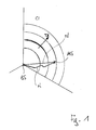
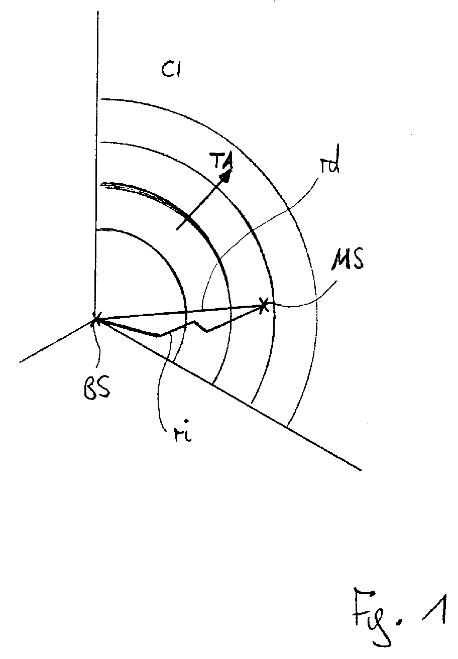
- a base station BS is shown which is associated with a cell having a cell identifier CI.
- a mobile station MS is located within the cell CI.
- a timing advance TA as already described, is represented in figure 1 as an arrow wherein the value of the timing advance TA increases by 1 in the direction of the arrow with every one of the shown angular ring segments.
- a direct distance rd between the base station and the mobile station MS is shown in figure 1. This distance rd is often called the line of sight between the base station BS and the mobile station MS. Furthermore, an indirect distance ri between the base station BS and the mobile station MS is shown in figure 1 which is the true transmission path from the base station BS to the mobile station MS including all diversions.
- the direct distance rd and the indirect distance ri constitute the axes of the diagram of figure 2.
- the timing advance TA is shown in figure 2. As the timing advance TA comprises all diversions of a transmission path, the timing advance TA is directed into the same direction as the indirect distance ri.
- a so-called network planning tool for planning a telecommunication network. For example, the optimal location of a specific base station within a cellular telecommunication network as well as the coverage of this base station can be evaluated by a network planning tool.
- a network planning tool is able to evaluate the direct distance rd between a base station and a specific mobile station being located within the respective cell. It is also known that this direct distance rd between a base station and a mobile station may be evaluated with the help of the Global Positioning System (GPS).
- GPS Global Positioning System
- the direct distances rd between the base station BS and the mobile station MS are evaluated for a number of locations L within the cell CI with the help of a network planning tool or with the help of the Global Positioning System (GPS).
- the locations L are selected such that the timing advance TA of these locations L is always the same.
- Some exemplary locations L are shown in figure 2. Their direct distances rd is equal to the corresponding values on the x-axis of the respective locations L.
- a second step the distances rd of all locations L with the same timing advance TA are averaged. The result is a mean distance for this timing advance TA. This mean distance for the relevant timing advance TA is shown in figure 2 as a location M.
- the first and the second step are repeated for all possible timing advances TA with the result that a number of mean distances are evaluated for the corresponding timing advances TA.
- three locations M are shown representing three mean distances for three consecutive timing advances T.
- This function is of the following general type representing any kind of curve: a0 + a1 x TA + a2 x TA 2 + a3 x TA 3 + ...
- the function may represent a straight line as follows: a0 + a1 x TA
- the values a0, a1, a2, a3, ... are calculated with the help of known mathematical and/or statistical methods and/or models based on the locations M representing the mean distances for the respective timing advances TA.
- a set of values a0, a1, a2, a3, ... which represents a curve or - as shown in figure 2 - a straight line AI which connects all locations M, i.e. all mean distances.
- the timing advance TA being relevant for the mobile station MS is evaluated as described by the base station BS. Then, an estimated direct distance rd* of the mobile station MS from the base station BS is calculated based on the values a0, a1, a2, a3, ... as determined for the relevant cell CI according to the above description and based on the evaluated timing advance TA.
- the actual location of the mobile station MS is evaluated with the help of the estimated direct distance rd* and known methods for location determination e.g. the transmission angle of the base station BS.
- the base station BS and the mobile station MS are shown.
- the timing advance TA is depicted as an arrow.
- the direct distance rd is shown as the shortest line between the base station BS and the mobile station MS.
- the indirect distance ri is shown firstly as a line with several angles representing some diversions, and secondly, below, as a straight line. Due to the diversions, the straight line of the indirect distance ri is longer than the direct distance rd.
- the estimated direct distance rd* is shown in figure 3.
- This distance rd* is evaluated as described above, in particular based on the values a0, a1, a2, a3, ... as described in connection with figure 2.
- the estimated direct distance rd* is calculated according to equation E.
- the estimated direct distance rd* is shorter than the calculated distance rk, the difference being abbreviated as G.
- the difference F2 between the estimated direct distance rd* and the direct distance rd is less than the difference Fl.
- the set of values a0, a1, a2, a3, ... can be classified depending on one or more characteristics of the cell CI. For example, if the cell CI covers e.g. a city, then the corresponding set of values a0, a1, a2, a3, ... is taken as a representative for an urban cell. However, if the cell CI covers a countryside, then the corresponding set of values a0, a1, a2, a3, ... is taken as a representative for a rural cell.
- this classification can be carried out e.g. before the telecommunication network is taken into operation.
- the described methods may be carried out anywhere within the cellular telecommunication network.
- the evaluations are performed by the base station BS or by a specific server within the cellular telecommunication network being connected to the base station BS.
Abstract
A cell is associated with a base station (BS). The mobile station (MS) is located within the cell. A timing advance (TA) is evaluated by the base station (BS).
The method comprises the following steps:
Description
- The invention relates to a method of evaluating a location of a mobile station within a cellular telecommunication network wherein a cell is associated with a base station, wherein the mobile station is located within the cell and wherein a timing advance is evaluated by the base station. The invention also relates to a corresponding base station and to a corresponding cellular telecommunication network.
- A cellular telecommunication network, e.g. the Global System for Mobile Communication (GSM), is built up of a number of cells. The surface covered by all cells defines the operating area of the network. Each cell is associated with at least one base station. A mobile station being located within a specific cell, can therefore communicate with at least one base station belonging to this cell.
- In connection with so-called location-based services, it is necessary to evaluate the actual location of a mobile station within the cell. For example, if all hotels in the vicinity of the actual location of a user of the mobile station shall be provided to this user, the actual location of this user must be evaluated in order to carry out this location-based service.
- It is known to evaluate the location of a mobile station within a cell as a function of a timing advance of the mobile station.
- This timing advance is defined by each base station belonging to the cell and forwarded to the mobile station. The timing advance corresponds to that time duration which is required for sending data from the mobile station to the base station. In order to arrive at the base station at a predefined point in time, the mobile station must send its data prior to this point in time, i.e. with the given timing advance.
- As described, the timing advance corresponds to the time duration required for transmitting data from the mobile station to the base station. The timing advance, therefore, depends on the distance of the mobile station to the base station. This results in the following known equation:
- rk = distance from mobile station to base station,
- k = constant value = e.g. 554 meters for GSM,
- TA = 0, 1, 2, ... = timing advance,
- offset = constant distance, e.g. k/2 or k/4.
-
- With the timing advance being evaluated by the base station as described above, the distance of the mobile station from the base station can be calculated with the above equation. Based on this distance, the location of the mobile station can then be evaluated and used in connection with location-based services.
- However, the distance calculated with the above equation does not exactly correspond to the actual distance of the mobile station from the base station. This comes from the fact that the evaluation of the timing advance is not based on the shortest distance between the mobile station and the base station but on the actual transmission path between the mobile station and the base station including all diversions of the transmitted data due to reflexions and the like.
- Therefore, the distance calculated with the above equation usually is longer than the actual distance between the mobile station and the base station.
- It is an object of the invention to provide a method of evaluating the distance between the mobile station and the base station more accurately.
- This object is solved by a method according to claim 1. The object is also solved by a base station according to claim 8 and by a cellular telecommunication network according to claim 9.
- The invention provides a simple, but accurate possibility to evaluate the distance between the mobile station and the base station. The evaluated distance can then be used for evaluating the location of the mobile station and its user for example in connection with location-based services. The accuracy of the evaluated distance and therefore the resulting location may be increased up to 20 percent compared to the described known evaluation.
- Further features, applications and advantages of the invention will become apparent from the following description of exemplary embodiments of the invention which are shown in the drawings. There, all described and shown features themselves or in any combination represent the subject-matter of the invention, independently of their wording in the description or their representation in the drawings and independently of their combination in the claims or the dependencies of the claims.
- Figure 1 of the drawings shows a schematic representation of a cell of a cellular telecommunication network, figure 2 shows a schematic diagram comprising a direct distance and an indirect distance between a base station and a mobile station, and figure 3 shows a schematic representation of the afore-mentioned and other distances.
- In the following description, the cellular telecommunication system is realized by the Global System for Mobile Communication (GSM). Of course, the cellular telecommunication system may also be realized by any other kind of technique, e.g. by the Universal Mobile Telecommunications System (UMTS). In the latter case, the described timing advance has to be replaced e.g. by the so-called round-trip-time or the like.
- In figure 1, a base station BS is shown which is associated with a cell having a cell identifier CI. A mobile station MS is located within the cell CI. A timing advance TA as already described, is represented in figure 1 as an arrow wherein the value of the timing advance TA increases by 1 in the direction of the arrow with every one of the shown angular ring segments.
- A direct distance rd between the base station and the mobile station MS is shown in figure 1. This distance rd is often called the line of sight between the base station BS and the mobile station MS. Furthermore, an indirect distance ri between the base station BS and the mobile station MS is shown in figure 1 which is the true transmission path from the base station BS to the mobile station MS including all diversions.
- The direct distance rd and the indirect distance ri constitute the axes of the diagram of figure 2. As well, the timing advance TA is shown in figure 2. As the timing advance TA comprises all diversions of a transmission path, the timing advance TA is directed into the same direction as the indirect distance ri.
- It is known to use a so-called network planning tool for planning a telecommunication network. For example, the optimal location of a specific base station within a cellular telecommunication network as well as the coverage of this base station can be evaluated by a network planning tool.
- In this connection, it is known that a network planning tool is able to evaluate the direct distance rd between a base station and a specific mobile station being located within the respective cell. It is also known that this direct distance rd between a base station and a mobile station may be evaluated with the help of the Global Positioning System (GPS).
- In a first step, the direct distances rd between the base station BS and the mobile station MS are evaluated for a number of locations L within the cell CI with the help of a network planning tool or with the help of the Global Positioning System (GPS). In this first step, the locations L are selected such that the timing advance TA of these locations L is always the same. Some exemplary locations L are shown in figure 2. Their direct distances rd is equal to the corresponding values on the x-axis of the respective locations L.
- It is mentioned that the direct distance rd of a specific location L is always equal or less as the indirect distance ri of this location L. Therefore, all locations L are present above a line XY which represents the bisecting line between the x-axis and the y-axis of the diagram of figure 2.
- In a second step, the distances rd of all locations L with the same timing advance TA are averaged. The result is a mean distance for this timing advance TA. This mean distance for the relevant timing advance TA is shown in figure 2 as a location M.
- In further steps, the first and the second step are repeated for all possible timing advances TA with the result that a number of mean distances are evaluated for the corresponding timing advances TA. In figure 2, three locations M are shown representing three mean distances for three consecutive timing advances T.
- Then, a function is evaluated for connecting all locations M of figure 2. This function is of the following general type representing any kind of curve:
- As well, the function may represent a straight line as follows:
- The values a0, a1, a2, a3, ... are calculated with the help of known mathematical and/or statistical methods and/or models based on the locations M representing the mean distances for the respective timing advances TA.
- As a result of the described method, a set of values a0, a1, a2, a3, ... is present which represents a curve or - as shown in figure 2 - a straight line AI which connects all locations M, i.e. all mean distances.
- All these measures can be carried out e.g. before the telecommunication network is taken into operation.
- Then, after the telecommunication network is taken into operation, the actual location of a mobile station MS can be evaluated as follows:
- The timing advance TA being relevant for the mobile station MS is evaluated as described by the base station BS. Then, an estimated direct distance rd* of the mobile station MS from the base station BS is calculated based on the values a0, a1, a2, a3, ... as determined for the relevant cell CI according to the above description and based on the evaluated timing advance TA. In general, the estimated direct distance rd* may be calculated as follows:
- In the example as shown in figure 2, the estimated direct distance rd* is calculated as follows:
- This estimated direct distance rd* is shown in figure 2.
- Finally, the actual location of the mobile station MS is evaluated with the help of the estimated direct distance rd* and known methods for location determination e.g. the transmission angle of the base station BS.
- In figure 3, the correlations between the different distances are shown which shall be described now.
- At the top of figure 3, the base station BS and the mobile station MS are shown. As well, the timing advance TA is depicted as an arrow.
- Below, the direct distance rd is shown as the shortest line between the base station BS and the mobile station MS.
- Then, the indirect distance ri is shown firstly as a line with several angles representing some diversions, and secondly, below, as a straight line. Due to the diversions, the straight line of the indirect distance ri is longer than the direct distance rd.
- For comparison purposes, the distance rk as calculated with equation A is shown. This distance rk is apparently longer than the straight line of the indirect distance ri. Furthermore, a difference F1 is shown in figure 3 between the direct distance rd and the calculated distance rk.
- Then, the estimated direct distance rd* is shown in figure 3. This distance rd* is evaluated as described above, in particular based on the values a0, a1, a2, a3, ... as described in connection with figure 2. For example, the estimated direct distance rd* is calculated according to equation E.
- Apparently, the estimated direct distance rd* is shorter than the calculated distance rk, the difference being abbreviated as G. As a consequence, the difference F2 between the estimated direct distance rd* and the direct distance rd is less than the difference Fl.
- In addition to the described steps, the set of values a0, a1, a2, a3, ... can be classified depending on one or more characteristics of the cell CI. For example, if the cell CI covers e.g. a city, then the corresponding set of values a0, a1, a2, a3, ... is taken as a representative for an urban cell. However, if the cell CI covers a countryside, then the corresponding set of values a0, a1, a2, a3, ... is taken as a representative for a rural cell.
- Again, this classification can be carried out e.g. before the telecommunication network is taken into operation.
- Then, e.g. if a new base station and therefore new cells are introduced in the telecommunication network, it can be evaluated whether this new cell has an urban or rural character. Depending on this evaluation, the corresponding set of values a0, a1, a2, a3, ... can be assigned to this new cell without any further evaluations.
- The described methods may be carried out anywhere within the cellular telecommunication network. In particular, the evaluations are performed by the base station BS or by a specific server within the cellular telecommunication network being connected to the base station BS.
Claims (9)
- A method of evaluating a location of a mobile station within a cellular telecommunication system,
wherein a cell (CI) is associated with a base station (BS), wherein the mobile station (MS) is located within the cell (CI) and wherein a timing advance (TA) is evaluated by the base station (BS),
comprising the following steps:evaluating a direct distance (rd) between the mobile station (MS) and the base station (BS) for a number of locations (L) of the mobile station (MS) within the cell (CI),evaluating common values (a0, a1, a2, a3, ...) depending on the direct distances (rd), andevaluating an estimated direct distance (rd*) of the mobile station (MS) from the base station (BS) depending on the common values (a0, a1, a2, a3, ...). - The method of claim 1 comprising the following further steps:evaluating mean distances (M) from the direct distances (rd) and evaluating the common values based on the mean distances (M).
- The method of claim 2 comprising the following further steps:evaluating the mean distances (M) for the same timing advance (TA) and evaluating the common values based on the mean distances (M) of the different timing advances (TA).
- The method of claim 1 wherein the estimated direct distance (rd*) is generally evaluated as follows:
- The method of claim 1 wherein the estimated direct distance (rd*) is calculated as follows:
- The method of claim 1 wherein the direct distance (rd) is evaluated with the help of a network planning tool and/or the Global Positioning System (GPS).
- The method of claim 1 wherein the common values (a0, a1, a2, a3, ...) are evaluated with the help of mathematical and/or statistical methods and/or models.
- A base station of a cellular telecommunication system for evaluating a location of a mobile station within the cellular telecommunication system,
wherein a cell (CI) is associated with the base station (BS), wherein the mobile station (MS) is located within the cell (CI), wherein a timing advance (TA) is evaluated by the base station (BS), and
wherein the base station (BS) is equipped to carry out the method of one of claims 1 to 7. - A cellular telecommunication network comprising a base station for evaluating a location of a mobile station within the cellular telecommunication system,
wherein a cell (CI) is associated with the base station (BS), wherein the mobile station (MS) is located within the cell (CI), wherein a timing advance (TA) is evaluated by the base station (BS), and
wherein the cellular telecommunication network, in particular a server within the cellular telecommunication system, is equipped to carry out the method of one of claims 1 to 7.
Priority Applications (5)
| Application Number | Priority Date | Filing Date | Title |
|---|---|---|---|
| DE60304721T DE60304721T2 (en) | 2003-12-18 | 2003-12-18 | A method for calculating the position of a mobile station in a cellular communication network |
| EP03293220A EP1545145B1 (en) | 2003-12-18 | 2003-12-18 | A method of evaluating a location of a mobile station within a cellular telecommunication network |
| AT03293220T ATE324018T1 (en) | 2003-12-18 | 2003-12-18 | METHOD FOR CALCULATING THE POSITION OF A MOBILE STATION IN A CELLULAR COMMUNICATIONS NETWORK |
| US11/002,421 US7224986B2 (en) | 2003-12-18 | 2004-12-03 | Method of evaluating a location of a mobile station within a cellular telecommunication network |
| CNB2004101013471A CN100415042C (en) | 2003-12-18 | 2004-12-17 | Method of evaluating a location of a mobile station within a cellular telecommunication network |
Applications Claiming Priority (1)
| Application Number | Priority Date | Filing Date | Title |
|---|---|---|---|
| EP03293220A EP1545145B1 (en) | 2003-12-18 | 2003-12-18 | A method of evaluating a location of a mobile station within a cellular telecommunication network |
Publications (2)
| Publication Number | Publication Date |
|---|---|
| EP1545145A1 true EP1545145A1 (en) | 2005-06-22 |
| EP1545145B1 EP1545145B1 (en) | 2006-04-19 |
Family
ID=34486490
Family Applications (1)
| Application Number | Title | Priority Date | Filing Date |
|---|---|---|---|
| EP03293220A Expired - Lifetime EP1545145B1 (en) | 2003-12-18 | 2003-12-18 | A method of evaluating a location of a mobile station within a cellular telecommunication network |
Country Status (5)
| Country | Link |
|---|---|
| US (1) | US7224986B2 (en) |
| EP (1) | EP1545145B1 (en) |
| CN (1) | CN100415042C (en) |
| AT (1) | ATE324018T1 (en) |
| DE (1) | DE60304721T2 (en) |
Cited By (6)
| Publication number | Priority date | Publication date | Assignee | Title |
|---|---|---|---|---|
| EP1906692A1 (en) * | 2006-09-26 | 2008-04-02 | Siemens Aktiengesellschaft | Method for determining the distance between nodes in a messaging network |
| WO2010093294A1 (en) * | 2009-02-11 | 2010-08-19 | Telefonaktiebolaget Lm Ericsson (Publ) | Method and arrangement for determining terminal position |
| WO2011095234A1 (en) * | 2010-02-04 | 2011-08-11 | Tomtom Development Germany Gmbh | Location-determining system and method |
| WO2012102649A1 (en) | 2011-01-25 | 2012-08-02 | Telefonaktiebolaget L M Ericsson (Publ) | Location server method for communicating location information |
| JP2012526425A (en) * | 2009-05-07 | 2012-10-25 | 電信科学技術研究院 | Method, system and apparatus for determining location information of user terminal |
| US8914038B2 (en) | 2009-02-11 | 2014-12-16 | Telefonaktiebolaget L M Ericsson (Publ) | Method and arrangement for determining terminal position |
Families Citing this family (9)
| Publication number | Priority date | Publication date | Assignee | Title |
|---|---|---|---|---|
| KR20050016929A (en) * | 2003-08-04 | 2005-02-21 | 삼성전자주식회사 | Multi-purpose terminal equipment capable of preparation for the fast task performance and the method thereof |
| KR20070032570A (en) * | 2005-09-16 | 2007-03-22 | 삼성전자주식회사 | Association Method in Network System and System therof |
| CN100421526C (en) * | 2005-12-20 | 2008-09-24 | 华为技术有限公司 | Method for user terminal to send up position information |
| US7974637B1 (en) | 2007-09-24 | 2011-07-05 | Mikael Bror Taveniku | Passive mode tracking through existing and future wireless networks |
| US8160609B2 (en) * | 2008-11-26 | 2012-04-17 | Andrew Llc | System and method for multiple range estimation location |
| US8249622B2 (en) | 2008-11-26 | 2012-08-21 | Andrew, Llc | System and method for multiple range estimation location |
| US20140071856A1 (en) * | 2012-09-10 | 2014-03-13 | At&T Mobility Ii Llc | Timing advance information for adapting neighbor relations |
| US8996000B2 (en) | 2012-09-10 | 2015-03-31 | At&T Mobility Ii Llc | Real-time load analysis for modification of neighbor relations |
| CN110087191B (en) * | 2018-01-24 | 2021-01-19 | 海能达通信股份有限公司 | Method and device for estimating time advance |
Citations (4)
| Publication number | Priority date | Publication date | Assignee | Title |
|---|---|---|---|---|
| US5974329A (en) * | 1997-09-29 | 1999-10-26 | Rutgers University | Method and system for mobile location estimation |
| US6097336A (en) * | 1999-01-08 | 2000-08-01 | Trueposition, Inc. | Method for improving the accuracy of a wireless location system |
| US6161018A (en) * | 1998-02-27 | 2000-12-12 | Motorola, Inc. | Method and system for estimating a subscriber's location in a wireless communication system service area |
| US20030036390A1 (en) * | 1999-01-09 | 2003-02-20 | Eric Villier | Method of and system for estimating a time of arrival of a radio signal |
Family Cites Families (7)
| Publication number | Priority date | Publication date | Assignee | Title |
|---|---|---|---|---|
| SE512065C2 (en) * | 1995-02-16 | 2000-01-24 | Europolitan Ab | Method and apparatus for determining a mobile station in a cellular mobile telephone system |
| FR2739243B1 (en) * | 1995-09-26 | 1997-11-14 | Alcatel Mobile Comm France | CELLULAR MOBILE RADIO COMMUNICATION SYSTEM, BASE STATION, AND CORRESPONDING BASE STATION CONTROL DEVICE |
| US6097959A (en) * | 1998-01-29 | 2000-08-01 | Ericsson Inc. | System and method for accurate positioning of mobile terminals |
| US20040198386A1 (en) * | 2002-01-16 | 2004-10-07 | Dupray Dennis J. | Applications for a wireless location gateway |
| DE10159086A1 (en) * | 2001-12-01 | 2003-06-12 | Alcatel Sa | Method for determining the distance between a mobile station and a base station |
| US20040203921A1 (en) * | 2003-03-21 | 2004-10-14 | Nicholas Bromhead | Sub-sector timing advance positions determinations |
| US20050053099A1 (en) * | 2003-09-05 | 2005-03-10 | Spear Stephen L. | Timing advance determinations in wireless communications devices and methods |
-
2003
- 2003-12-18 DE DE60304721T patent/DE60304721T2/en not_active Expired - Fee Related
- 2003-12-18 EP EP03293220A patent/EP1545145B1/en not_active Expired - Lifetime
- 2003-12-18 AT AT03293220T patent/ATE324018T1/en not_active IP Right Cessation
-
2004
- 2004-12-03 US US11/002,421 patent/US7224986B2/en not_active Expired - Fee Related
- 2004-12-17 CN CNB2004101013471A patent/CN100415042C/en not_active Expired - Fee Related
Patent Citations (4)
| Publication number | Priority date | Publication date | Assignee | Title |
|---|---|---|---|---|
| US5974329A (en) * | 1997-09-29 | 1999-10-26 | Rutgers University | Method and system for mobile location estimation |
| US6161018A (en) * | 1998-02-27 | 2000-12-12 | Motorola, Inc. | Method and system for estimating a subscriber's location in a wireless communication system service area |
| US6097336A (en) * | 1999-01-08 | 2000-08-01 | Trueposition, Inc. | Method for improving the accuracy of a wireless location system |
| US20030036390A1 (en) * | 1999-01-09 | 2003-02-20 | Eric Villier | Method of and system for estimating a time of arrival of a radio signal |
Cited By (9)
| Publication number | Priority date | Publication date | Assignee | Title |
|---|---|---|---|---|
| EP1906692A1 (en) * | 2006-09-26 | 2008-04-02 | Siemens Aktiengesellschaft | Method for determining the distance between nodes in a messaging network |
| WO2010093294A1 (en) * | 2009-02-11 | 2010-08-19 | Telefonaktiebolaget Lm Ericsson (Publ) | Method and arrangement for determining terminal position |
| US8135416B2 (en) | 2009-02-11 | 2012-03-13 | Telefonaktiebolaget Lm Ericsson (Publ) | Method and arrangement for determining terminal position |
| US8914038B2 (en) | 2009-02-11 | 2014-12-16 | Telefonaktiebolaget L M Ericsson (Publ) | Method and arrangement for determining terminal position |
| CN102318416B (en) * | 2009-02-11 | 2015-06-24 | 瑞典爱立信有限公司 | Method and arrangement for determining terminal position |
| JP2012526425A (en) * | 2009-05-07 | 2012-10-25 | 電信科学技術研究院 | Method, system and apparatus for determining location information of user terminal |
| WO2011095234A1 (en) * | 2010-02-04 | 2011-08-11 | Tomtom Development Germany Gmbh | Location-determining system and method |
| US8594700B2 (en) | 2010-02-04 | 2013-11-26 | Jan Nabbefeld | Location-determining system and method |
| WO2012102649A1 (en) | 2011-01-25 | 2012-08-02 | Telefonaktiebolaget L M Ericsson (Publ) | Location server method for communicating location information |
Also Published As
| Publication number | Publication date |
|---|---|
| DE60304721T2 (en) | 2006-11-09 |
| DE60304721D1 (en) | 2006-05-24 |
| ATE324018T1 (en) | 2006-05-15 |
| CN100415042C (en) | 2008-08-27 |
| US7224986B2 (en) | 2007-05-29 |
| US20050136948A1 (en) | 2005-06-23 |
| CN1630423A (en) | 2005-06-22 |
| EP1545145B1 (en) | 2006-04-19 |
Similar Documents
| Publication | Publication Date | Title |
|---|---|---|
| EP1545145A1 (en) | A method of evaluating a location of a mobile station within a cellular telecommunication network | |
| EP3324657B1 (en) | Location services in a telecommunications system | |
| CN102869038B (en) | Measurement compensation method and device in positioning of base station, server and system | |
| CN100496150C (en) | Communication system and method for providing position information | |
| CN100534235C (en) | Method and system for validating mobile station location fix | |
| US6774842B2 (en) | Generating entries for a database supporting a positioning of a mobile terminal | |
| EP2640116B1 (en) | Calibration method and device for coverage database | |
| CN101336556B (en) | Method and arrangement for high precision position reference measurements at indoor locations | |
| CN101536596B (en) | Method and device for determination of the position of a terminal in a mobile communication network | |
| EP1193990A1 (en) | Method and apparatus for estimating the location of a mobile terminal | |
| US20020094824A1 (en) | Method and system for applying wireless geolocation technology | |
| EP1301055A1 (en) | Processing of geographical and movement data for locating a mobile terminal in a mobile network | |
| CN101083796A (en) | Location service providing system and method for providing triggered location request service | |
| US20040132464A1 (en) | Location system | |
| EP3589979A1 (en) | Method, devices, system and computer program product for increasing the positioning accuracy of a mobile user equipment by using data of a global navigation satellite system | |
| CN101815350B (en) | Method for positioning user equipment and user equipment therefor | |
| Laitinen et al. | Cellular location technology | |
| KR100524180B1 (en) | Position tracking method of a mobile phone using cell position and receiving/pre-measured radio wave characteristic information | |
| EP1302783A1 (en) | Location of a mobile terminal | |
| US7873375B2 (en) | Method for the location of mobile terminals, related systems and terminal, computer program products thereof | |
| US20040127160A1 (en) | Determining neighbour lists | |
| US7242349B2 (en) | Method of increasing the accuracy of geographical information of a mobile station of a radio communication system | |
| EP1359431A1 (en) | Method and corresponding server for determining the position of a moving mobile terminal | |
| CN114363806A (en) | High-precision 5G triangulation method | |
| KR100882218B1 (en) | Method and System for Measuring Position for Use in Network Based Location Based Service by Using Round Trip Delay |
Legal Events
| Date | Code | Title | Description |
|---|---|---|---|
| PUAI | Public reference made under article 153(3) epc to a published international application that has entered the european phase |
Free format text: ORIGINAL CODE: 0009012 |
|
| 17P | Request for examination filed |
Effective date: 20040804 |
|
| AK | Designated contracting states |
Kind code of ref document: A1 Designated state(s): AT BE BG CH CY CZ DE DK EE ES FI FR GB GR HU IE IT LI LU MC NL PT RO SE SI SK TR |
|
| AX | Request for extension of the european patent |
Extension state: AL LT LV MK |
|
| GRAP | Despatch of communication of intention to grant a patent |
Free format text: ORIGINAL CODE: EPIDOSNIGR1 |
|
| GRAS | Grant fee paid |
Free format text: ORIGINAL CODE: EPIDOSNIGR3 |
|
| GRAA | (expected) grant |
Free format text: ORIGINAL CODE: 0009210 |
|
| AKX | Designation fees paid |
Designated state(s): AT BE BG CH CY CZ DE DK EE ES FI FR GB GR HU IE IT LI LU MC NL PT RO SE SI SK TR |
|
| AK | Designated contracting states |
Kind code of ref document: B1 Designated state(s): AT BE BG CH CY CZ DE DK EE ES FI FR GB GR HU IE IT LI LU MC NL PT RO SE SI SK TR |
|
| PG25 | Lapsed in a contracting state [announced via postgrant information from national office to epo] |
Ref country code: SK Free format text: LAPSE BECAUSE OF FAILURE TO SUBMIT A TRANSLATION OF THE DESCRIPTION OR TO PAY THE FEE WITHIN THE PRESCRIBED TIME-LIMIT Effective date: 20060419 Ref country code: AT Free format text: LAPSE BECAUSE OF FAILURE TO SUBMIT A TRANSLATION OF THE DESCRIPTION OR TO PAY THE FEE WITHIN THE PRESCRIBED TIME-LIMIT Effective date: 20060419 Ref country code: CZ Free format text: LAPSE BECAUSE OF FAILURE TO SUBMIT A TRANSLATION OF THE DESCRIPTION OR TO PAY THE FEE WITHIN THE PRESCRIBED TIME-LIMIT Effective date: 20060419 Ref country code: BE Free format text: LAPSE BECAUSE OF FAILURE TO SUBMIT A TRANSLATION OF THE DESCRIPTION OR TO PAY THE FEE WITHIN THE PRESCRIBED TIME-LIMIT Effective date: 20060419 Ref country code: CH Free format text: LAPSE BECAUSE OF FAILURE TO SUBMIT A TRANSLATION OF THE DESCRIPTION OR TO PAY THE FEE WITHIN THE PRESCRIBED TIME-LIMIT Effective date: 20060419 Ref country code: SI Free format text: LAPSE BECAUSE OF FAILURE TO SUBMIT A TRANSLATION OF THE DESCRIPTION OR TO PAY THE FEE WITHIN THE PRESCRIBED TIME-LIMIT Effective date: 20060419 Ref country code: RO Free format text: LAPSE BECAUSE OF FAILURE TO SUBMIT A TRANSLATION OF THE DESCRIPTION OR TO PAY THE FEE WITHIN THE PRESCRIBED TIME-LIMIT Effective date: 20060419 Ref country code: FI Free format text: LAPSE BECAUSE OF FAILURE TO SUBMIT A TRANSLATION OF THE DESCRIPTION OR TO PAY THE FEE WITHIN THE PRESCRIBED TIME-LIMIT Effective date: 20060419 Ref country code: LI Free format text: LAPSE BECAUSE OF FAILURE TO SUBMIT A TRANSLATION OF THE DESCRIPTION OR TO PAY THE FEE WITHIN THE PRESCRIBED TIME-LIMIT Effective date: 20060419 Ref country code: NL Free format text: LAPSE BECAUSE OF FAILURE TO SUBMIT A TRANSLATION OF THE DESCRIPTION OR TO PAY THE FEE WITHIN THE PRESCRIBED TIME-LIMIT Effective date: 20060419 |
|
| REG | Reference to a national code |
Ref country code: GB Ref legal event code: FG4D |
|
| REF | Corresponds to: |
Ref document number: 60304721 Country of ref document: DE Date of ref document: 20060524 Kind code of ref document: P |
|
| REG | Reference to a national code |
Ref country code: IE Ref legal event code: FG4D |
|
| PG25 | Lapsed in a contracting state [announced via postgrant information from national office to epo] |
Ref country code: DK Free format text: LAPSE BECAUSE OF FAILURE TO SUBMIT A TRANSLATION OF THE DESCRIPTION OR TO PAY THE FEE WITHIN THE PRESCRIBED TIME-LIMIT Effective date: 20060719 Ref country code: SE Free format text: LAPSE BECAUSE OF FAILURE TO SUBMIT A TRANSLATION OF THE DESCRIPTION OR TO PAY THE FEE WITHIN THE PRESCRIBED TIME-LIMIT Effective date: 20060719 |
|
| PG25 | Lapsed in a contracting state [announced via postgrant information from national office to epo] |
Ref country code: ES Free format text: LAPSE BECAUSE OF FAILURE TO SUBMIT A TRANSLATION OF THE DESCRIPTION OR TO PAY THE FEE WITHIN THE PRESCRIBED TIME-LIMIT Effective date: 20060730 |
|
| PG25 | Lapsed in a contracting state [announced via postgrant information from national office to epo] |
Ref country code: PT Free format text: LAPSE BECAUSE OF FAILURE TO SUBMIT A TRANSLATION OF THE DESCRIPTION OR TO PAY THE FEE WITHIN THE PRESCRIBED TIME-LIMIT Effective date: 20060919 |
|
| NLV1 | Nl: lapsed or annulled due to failure to fulfill the requirements of art. 29p and 29m of the patents act | ||
| ET | Fr: translation filed | ||
| REG | Reference to a national code |
Ref country code: CH Ref legal event code: PL |
|
| PG25 | Lapsed in a contracting state [announced via postgrant information from national office to epo] |
Ref country code: IE Free format text: LAPSE BECAUSE OF NON-PAYMENT OF DUE FEES Effective date: 20061218 |
|
| PG25 | Lapsed in a contracting state [announced via postgrant information from national office to epo] |
Ref country code: MC Free format text: LAPSE BECAUSE OF NON-PAYMENT OF DUE FEES Effective date: 20061231 |
|
| PLBE | No opposition filed within time limit |
Free format text: ORIGINAL CODE: 0009261 |
|
| STAA | Information on the status of an ep patent application or granted ep patent |
Free format text: STATUS: NO OPPOSITION FILED WITHIN TIME LIMIT |
|
| 26N | No opposition filed |
Effective date: 20070122 |
|
| PGFP | Annual fee paid to national office [announced via postgrant information from national office to epo] |
Ref country code: IT Payment date: 20071219 Year of fee payment: 5 |
|
| PG25 | Lapsed in a contracting state [announced via postgrant information from national office to epo] |
Ref country code: GR Free format text: LAPSE BECAUSE OF FAILURE TO SUBMIT A TRANSLATION OF THE DESCRIPTION OR TO PAY THE FEE WITHIN THE PRESCRIBED TIME-LIMIT Effective date: 20060720 |
|
| PGFP | Annual fee paid to national office [announced via postgrant information from national office to epo] |
Ref country code: GB Payment date: 20071218 Year of fee payment: 5 |
|
| PGFP | Annual fee paid to national office [announced via postgrant information from national office to epo] |
Ref country code: DE Payment date: 20071221 Year of fee payment: 5 |
|
| PG25 | Lapsed in a contracting state [announced via postgrant information from national office to epo] |
Ref country code: BG Free format text: LAPSE BECAUSE OF FAILURE TO SUBMIT A TRANSLATION OF THE DESCRIPTION OR TO PAY THE FEE WITHIN THE PRESCRIBED TIME-LIMIT Effective date: 20060719 Ref country code: EE Free format text: LAPSE BECAUSE OF FAILURE TO SUBMIT A TRANSLATION OF THE DESCRIPTION OR TO PAY THE FEE WITHIN THE PRESCRIBED TIME-LIMIT Effective date: 20060419 |
|
| PG25 | Lapsed in a contracting state [announced via postgrant information from national office to epo] |
Ref country code: LU Free format text: LAPSE BECAUSE OF NON-PAYMENT OF DUE FEES Effective date: 20061218 Ref country code: TR Free format text: LAPSE BECAUSE OF FAILURE TO SUBMIT A TRANSLATION OF THE DESCRIPTION OR TO PAY THE FEE WITHIN THE PRESCRIBED TIME-LIMIT Effective date: 20060419 Ref country code: HU Free format text: LAPSE BECAUSE OF FAILURE TO SUBMIT A TRANSLATION OF THE DESCRIPTION OR TO PAY THE FEE WITHIN THE PRESCRIBED TIME-LIMIT Effective date: 20061020 |
|
| PGFP | Annual fee paid to national office [announced via postgrant information from national office to epo] |
Ref country code: FR Payment date: 20071217 Year of fee payment: 5 |
|
| PG25 | Lapsed in a contracting state [announced via postgrant information from national office to epo] |
Ref country code: CY Free format text: LAPSE BECAUSE OF FAILURE TO SUBMIT A TRANSLATION OF THE DESCRIPTION OR TO PAY THE FEE WITHIN THE PRESCRIBED TIME-LIMIT Effective date: 20060419 |
|
| GBPC | Gb: european patent ceased through non-payment of renewal fee |
Effective date: 20081218 |
|
| REG | Reference to a national code |
Ref country code: FR Ref legal event code: ST Effective date: 20090831 |
|
| PG25 | Lapsed in a contracting state [announced via postgrant information from national office to epo] |
Ref country code: DE Free format text: LAPSE BECAUSE OF NON-PAYMENT OF DUE FEES Effective date: 20090701 |
|
| PG25 | Lapsed in a contracting state [announced via postgrant information from national office to epo] |
Ref country code: GB Free format text: LAPSE BECAUSE OF NON-PAYMENT OF DUE FEES Effective date: 20081218 |
|
| PG25 | Lapsed in a contracting state [announced via postgrant information from national office to epo] |
Ref country code: FR Free format text: LAPSE BECAUSE OF NON-PAYMENT OF DUE FEES Effective date: 20081231 |
|
| PG25 | Lapsed in a contracting state [announced via postgrant information from national office to epo] |
Ref country code: IT Free format text: LAPSE BECAUSE OF NON-PAYMENT OF DUE FEES Effective date: 20081218 |