EP1136788A1 - Portable GPS receiver using a barometric altimeter - Google Patents
Portable GPS receiver using a barometric altimeter Download PDFInfo
- Publication number
- EP1136788A1 EP1136788A1 EP00201021A EP00201021A EP1136788A1 EP 1136788 A1 EP1136788 A1 EP 1136788A1 EP 00201021 A EP00201021 A EP 00201021A EP 00201021 A EP00201021 A EP 00201021A EP 1136788 A1 EP1136788 A1 EP 1136788A1
- Authority
- EP
- European Patent Office
- Prior art keywords
- receiver
- altimeter
- processing unit
- height
- data
- Prior art date
- Legal status (The legal status is an assumption and is not a legal conclusion. Google has not performed a legal analysis and makes no representation as to the accuracy of the status listed.)
- Withdrawn
Links
Images


Classifications
-
- G—PHYSICS
- G01—MEASURING; TESTING
- G01S—RADIO DIRECTION-FINDING; RADIO NAVIGATION; DETERMINING DISTANCE OR VELOCITY BY USE OF RADIO WAVES; LOCATING OR PRESENCE-DETECTING BY USE OF THE REFLECTION OR RERADIATION OF RADIO WAVES; ANALOGOUS ARRANGEMENTS USING OTHER WAVES
- G01S19/00—Satellite radio beacon positioning systems; Determining position, velocity or attitude using signals transmitted by such systems
- G01S19/01—Satellite radio beacon positioning systems transmitting time-stamped messages, e.g. GPS [Global Positioning System], GLONASS [Global Orbiting Navigation Satellite System] or GALILEO
- G01S19/13—Receivers
- G01S19/35—Constructional details or hardware or software details of the signal processing chain
- G01S19/37—Hardware or software details of the signal processing chain
-
- G—PHYSICS
- G01—MEASURING; TESTING
- G01C—MEASURING DISTANCES, LEVELS OR BEARINGS; SURVEYING; NAVIGATION; GYROSCOPIC INSTRUMENTS; PHOTOGRAMMETRY OR VIDEOGRAMMETRY
- G01C5/00—Measuring height; Measuring distances transverse to line of sight; Levelling between separated points; Surveyors' levels
- G01C5/06—Measuring height; Measuring distances transverse to line of sight; Levelling between separated points; Surveyors' levels by using barometric means
-
- G—PHYSICS
- G01—MEASURING; TESTING
- G01S—RADIO DIRECTION-FINDING; RADIO NAVIGATION; DETERMINING DISTANCE OR VELOCITY BY USE OF RADIO WAVES; LOCATING OR PRESENCE-DETECTING BY USE OF THE REFLECTION OR RERADIATION OF RADIO WAVES; ANALOGOUS ARRANGEMENTS USING OTHER WAVES
- G01S19/00—Satellite radio beacon positioning systems; Determining position, velocity or attitude using signals transmitted by such systems
- G01S19/01—Satellite radio beacon positioning systems transmitting time-stamped messages, e.g. GPS [Global Positioning System], GLONASS [Global Orbiting Navigation Satellite System] or GALILEO
- G01S19/13—Receivers
- G01S19/34—Power consumption
-
- G—PHYSICS
- G01—MEASURING; TESTING
- G01S—RADIO DIRECTION-FINDING; RADIO NAVIGATION; DETERMINING DISTANCE OR VELOCITY BY USE OF RADIO WAVES; LOCATING OR PRESENCE-DETECTING BY USE OF THE REFLECTION OR RERADIATION OF RADIO WAVES; ANALOGOUS ARRANGEMENTS USING OTHER WAVES
- G01S19/00—Satellite radio beacon positioning systems; Determining position, velocity or attitude using signals transmitted by such systems
- G01S19/38—Determining a navigation solution using signals transmitted by a satellite radio beacon positioning system
- G01S19/39—Determining a navigation solution using signals transmitted by a satellite radio beacon positioning system the satellite radio beacon positioning system transmitting time-stamped messages, e.g. GPS [Global Positioning System], GLONASS [Global Orbiting Navigation Satellite System] or GALILEO
- G01S19/42—Determining position
- G01S19/45—Determining position by combining measurements of signals from the satellite radio beacon positioning system with a supplementary measurement
- G01S19/47—Determining position by combining measurements of signals from the satellite radio beacon positioning system with a supplementary measurement the supplementary measurement being an inertial measurement, e.g. tightly coupled inertial
-
- G—PHYSICS
- G01—MEASURING; TESTING
- G01S—RADIO DIRECTION-FINDING; RADIO NAVIGATION; DETERMINING DISTANCE OR VELOCITY BY USE OF RADIO WAVES; LOCATING OR PRESENCE-DETECTING BY USE OF THE REFLECTION OR RERADIATION OF RADIO WAVES; ANALOGOUS ARRANGEMENTS USING OTHER WAVES
- G01S19/00—Satellite radio beacon positioning systems; Determining position, velocity or attitude using signals transmitted by such systems
- G01S19/38—Determining a navigation solution using signals transmitted by a satellite radio beacon positioning system
- G01S19/39—Determining a navigation solution using signals transmitted by a satellite radio beacon positioning system the satellite radio beacon positioning system transmitting time-stamped messages, e.g. GPS [Global Positioning System], GLONASS [Global Orbiting Navigation Satellite System] or GALILEO
- G01S19/42—Determining position
- G01S19/50—Determining position whereby the position solution is constrained to lie upon a particular curve or surface, e.g. for locomotives on railway tracks
Definitions
- the invention relates to a portable device for determining positions horizontal and vertical including an altimeter with pressure sensor calibrated at one predetermined initial height, a GPS signal receiver arranged to receive signals from multiple satellites to calculate data from positions of the device, a processing unit receiving the position data of the receiver and an altimeter height value based on pressure measurements of the pressure sensor relative to the predetermined height, and means display of the horizontal and vertical positions of the device processed and provided by the processing unit, as well as a method for activating said device.
- the altimeter can be calibrated using data provided by the GPS receiver according to a known geographical point recorded for example in a memory which can be associated with it.
- the pressure sensor is capable of providing measurements of pressure variations to be able to give altitude precisely during a period time determined also depending on weather conditions by example if the device is used for a hike.
- GOLD code a specific code defining its position precisely. All satellites send their own code at the same time each clocked atomic calibrated. However, there may be a slight time difference. produce between one and the other clocks, because they were not calibrated at the same time before each satellite goes into orbit. However, these time differences are insignificant in relation to the errors of calculated positions of the GPS systems put at the available to the public.
- Any GPS receiver device can receive signals from satellites in orbit, the distance to the ground of which can be between 20,000 km, when one of these satellites is at the Zenith, and 26,000 km, when one of these satellites is at a point of the tangent with the surface of the Earth.
- an altimeter with a GPS receiver in such a device gives the advantage of providing more precise values at altitude than those calculated only by the GPS receiver according to the radio waves it has received, to as long as the altimeter has been previously calibrated to a known height.
- the document US 5,210,540 describes such a device for determining the horizontal position X, Y and the altitude Z.
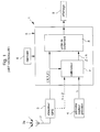
- the device 1 comprises a GPS receiver 3 receiving at a antenna 2 of radio waves 2a emitted by several satellites, a sensor altimeter pressure 4 calculating an altitude value as a function of a pressure measurement, a processing unit 5 receiving position data from the GPS receiver 3 and from altimeter 4 in order to process the data received in order to be able to display a position in X, Y and Z on a display means 9, and storage means 6 comprising cartographic data.
- a calibrator 7 for be able to calibrate the height provided by the altimeter in order to use this value of reference for subsequent position determination.
- the receiver GPS only calculates the data corresponding to positions X and Y, and therefore to pass from a three-dimensional mode to a two-dimensional mode.
- a disadvantage of such a device which is intended to equip a vehicle in the purpose of giving navigation information basically lies in the fact that it consumes a lot of electrical energy.
- this device can be powered by the vehicle battery without affecting its supply energy to other electrical parts of the vehicle.
- such a device does not cannot be used in a low power device such as a phone wearable or wrist watch.
- An object which the object of the invention proposes to resolve consists of a device for determining the horizontal and vertical positions in which a altimeter with pressure sensor calibrated at a predetermined initial height for the height measurement is used in combination with data provided by the GPS receiver in order to overcome the drawbacks of the devices of the prior art.
- Another object which the object of the invention proposes to resolve consists in a method of determining horizontal and vertical positions for actuation of said device.
- Another object which the object of the invention proposes to resolve consists in a use of the device to be able to assess weather forecasts.
- the processing unit sends a signal to the GPS receiver corresponding to the height value of the altimeter calibrated to allow means of calculation of the receiver to determine, using the height value, the device position data.
- the method for the activation of the device which is characterized in that it comprises the stages of calibrate the pressure sensor altimeter to a predetermined initial height using of data processed and supplied by the processing unit, transmit a value of height of the altimeter calibrated to the processing unit, send a corresponding signal to the height value of the calibrated altimeter from the processing unit to the receiver GPS to allow the receiver to determine, using the height value, the position data as a function of radio waves received from several satellites, and transmit the position data calculated by the receiver to the unit of processing so that they are processed and displayed on display means.
- the pressure sensor altimeter calibrated at a predetermined initial height is arranged to provide, at a height equivalent to a height stored in a previous time period, pressure changes converted to changes in height transmitted to the processing unit to determine conditions weather to display.
- An advantage of the device for determining the horizontal and vertical according to the invention resides in that it consumes little electrical energy thanks in particular to the reduction of the computation time in the GPS receiver with the data precise altitude supplied, in a return loop, by the processing unit on the base the precise height value from the calibrated altimeter, and using Low power microprocessors such as 8-bit microprocessors.
- the receiver will be able to do fewer iterations in the calculation operations to converge more quickly to the data of positions to be provided to the processing unit.
- the calculation error gives an incorrect result which can be much higher than inherent inaccuracy in GPS receiver devices, such as an error greater than ⁇ 150m for a vertical position.
- the low consumption of electrical energy thus makes it possible to envisage a integration of all the elements of the device, powered by a battery or a accumulator for low currents, in a timepiece, such as a wristwatch, or even in a small device, such as a phone portable.
- Another advantage of the device according to the invention consists in that it can be used to give weather conditions thanks to the altimeter with sensor of pressure.
- the variations of the altimeter sensor are used to define weather conditions for the day. If the altimeter reads + 50m by example, it means low pressure, on the other hand if it indicates -50m, it means high pressure.
- the altimeter sensor needs to be recalibrated at an precise predetermined height to serve, as previously described, for receiver calculation operations.
- FIG. 2 schematically represents the portable device 10 for the determination of horizontal and vertical positions, i.e. along the X, Y and Z.
- Horizontal positions are generally defined by longitude and latitude, and the vertical position is defined by the height above sea level.
- the portable device can be incorporated as well in a wristwatch with electronic timepiece, phone or other device electronic on a human scale which is easy to transport.
- the device is powered by a battery or accumulator for low currents of the watch, phone or device.
- the device comprises a GPS receiver 12 which receives at an antenna 11 radio waves from several satellites 20, storage means 13 of cartographic data associated in this case with the GPS receiver 12, a altimeter with pressure sensor 15 intended to measure pressure variations converted into a height value, a processing unit 14 receiving information to be processed from the receiver and the altimeter, and display means 16 for display at least the horizontal and vertical positions processed by the processing unit.
- the device 10 is incorporated in a wristwatch with analog or digital display
- all the components mentioned above are in principle fixed on a common support which is a printed circuit with metallic tracks connecting each component produced on one or two faces of an insulating substrate and connecting the battery for power supply.
- the support carrying all components is housed in the watch case leaving at least one opening towards the outside for pressure measurement by the altimeter sensor.
- Three satellites are sufficient to precisely determine the horizontal positions and vertical of the device provided that the clock of the receiver 12 is synchronized to that of the atomic clocks of said satellites. Otherwise, it is the receiver must be connected to at least four satellites, the fourth allowing the updating of the time base of the receiver, that is to say the synchronization of its internal clock.
- the determination of the position is relative to the determination of the intervals of time between radio signals received by the receiver of each of the four satellites questioned who each emitted at the same time their specific message with their ephemeris (GOLD code).
- the reception time of each radio signal therefore determines the distance from the reception point to the corresponding satellite since the code received from each of the satellites contains information about its position in orbit.
- the time taken by the signal from the satellite to the receiver multiplied by the speed of light gives the distance between the receiver and the satellite, which allows using the four satellites to deduce the position of the device in relation to so-called satellites.
- the altimeter 15 of the device 10 must be calibrated precisely at a predetermined height h in order to be able to base it on the value of precise height given by the altimeter especially for the operations of calculating the receiver when using the device as will be explained more detailed below with reference to Figure 3.
- the pressure sensor used in the altimeter 15 can be a piezoresistive sensor of known type made on a micro-machined silicon element having a membrane one side of which is exposed to ambient pressure and the other side of which carries resistors arranged in Wheatstone bridge. Any variation in pressure creates a unbalance of the bridge giving a voltage variation between the output terminals of said bridge.
- the sensor can be of the AM761 type which is marketed by the company Intersema Sensoric in Bevaix, Switzerland.
- the altimeter with pressure sensor When starting a hike, the altimeter with pressure sensor is therefore calibrated to a predetermined height which usually comes from the receiver GPS 12 in combination with precise cartographic data of a region of use of the device recorded for example in a memory 13.
- the height precise known from the starting location taken for example from memory 13 is brought to the processing unit 14 which returns it to the altimeter with pressure sensor 15 for a calibration operation.
- a comparison is normally made between the position data calculated by the GPS receiver and the precise data of several points of reference of a geographic map recorded in said memory. If the position horizontal (X, Y) or the horizontal and vertical positions (X, Y, Z) correspond to a precise data recorded, then at least the precise value of the height drawn memory is transmitted to the unit for the altimeter calibration.
- the memory 13 used in association with the GPS receiver 12 is by example EEPROM memory.
- EEPROM memory In this memory, it is possible to program electrically map data of a specific region in order to have in said memory precise values in X, Y and Z of a starting place or during a getaway, or also contour lines. Usually this is the given in Z which is communicated to the processing unit 14 by the receiver 12 of a specific location.
- calibrating the altimeter at a predetermined height can also be carried out in any other way than that described above, for example in entering the height value using a keyboard or by downloading directly in the processing unit.
- altimeter 15 is intended to make pressure measurements converted into height data relating to the predetermined height following the calibration during the hike and depending on weather conditions, i.e. during a period, for example 5 to 6 hours, when said conditions do not not vary too much.
- weather conditions i.e. during a period, for example 5 to 6 hours
- altitude difference i.e. for a change of 10 hectoPascal in change pressure corresponds to an altitude difference of 100m.
- the precise height value h of the calibrated altimeter 15 is transmitted to the unit 14 which sends a signal corresponding to this precise height value to the GPS 12 receiver in order to facilitate the data calculation operations horizontal and vertical as explained above. Taking into account the height of the altimeter 15 therefore makes it possible to reduce the iterations of the receiver for the calculation position values X, Y (longitude and latitude) and Z.
- the device 10 can provide on display means and on request, for example by pressing a button dedicated device control, or automatically at regular intervals, the value of the altitude Z, or h of the altimeter, and of the position in X and Y (longitude and latitude) by the data from the receiver 12 supplied to the processing unit 14.
- the signals transmitted to the processing 14 from GPS receiver 12 and altimeter15 include also parameters or quality factor of the data transmitted.
- DOPG quality parameters called DOPG defining a generalized reduction in precision are transmitted at the same time as position data (X, Y, Z). These parameters are also taken from signals received from satellites 20 where they can be broken down for example into HDOP for the horizontal position and in VDOP for the vertical position. These parameters allow the processing unit to know how accurate the position data calculated by the receiver. If this factor is 20, this means that the accuracy is poor, however if this factor approaches 1, this means that the accuracy is good. The processing unit transmits this data additional to display on the display means 16 to warn the user of the the quality of the measurement carried out.
- the quality factor QUAL is transmitted at the same time than the height value h at the processing unit.
- This factor can be for example representative of the height accuracy provided by the altimeter as a function of time flowing since the previous calibration of the pressure sensor of said altimeter 15. It has a value of 1 just after calibration and decreases almost linearly as function of the time which passes in a period of 5 to 6 hours as indicated above.
- the unit of treatment may decide whether to recalibrate the sensor so that it can subsequently provide a height value based on a new height predetermined at the GPS receiver for all subsequent calculation operations positions.
- the horizontal accuracy will always remain within ⁇ 100m even if the height is very precise.
- the time taken to calculate the receiver is greatly reduced, resulting in limited consumption of the receiver.
- X, Y positions calculated by the GPS 12 receiver, as well as the precise height value can be recorded in memory 13 to increase the number of place reference points listed.
- the device 10 can also be used to evaluate forecasts weather. At the same known and recorded altitude, any variation in pressure of altimeter 15 pressure sensor relative to a pressure value from a previous calibration may reflect barometric trends.
- the unit of processing in this case, will take the height value transmitted by the altimeter and the compare with a previous value recorded at the same altitude.
- This information processed by the processing unit can be displayed by the device to give an indication of the weather conditions to his user before going on a hike and before having to calibrate again the altimeter to a precise height memorized.
- EP 0 670 532 From the applicant describing a weather watch.
- a climatic variation is measured between 0.6 to 1.6 mbar / h between a low and a strong climatic disturbance, while the measurement of a variation in altitude is around 30 mbar / h for a height of 300 m which can be much higher than climatic variation during a hike.
- the height given by the altimeter can be considered as precise even with a slight influence of climatic variation.
- climatic variations can be controlled by the unit for the weather forecast for the coming day.
- FIG 3 shows in more detail the electronic blocks of the GPS receiver associated with storage means, such as a memory EEPROM 13 described previously with reference to Figure 2.
- Said receiver comprises an antenna 11 for receiving the radio signals to carrier frequency of 1.57542 GHz from several satellites 20, a first radio frequency conversion circuit 21 receiving the signals 31 from the antenna 11 for operate the signal frequency 31 to provide signals 32 at a frequency of the order of 180 MHz, a second conversion circuit 22 receiving the signals 32 to operate a reduction in the frequency of the signals 32 to supply signals 33 at a frequency of the order of 4 MHz, a correlator 23 receiving signals 33 and comprising a series of reduction stages for ability to derive radio codes received from the antenna specific codes for each satellite, an 8-bit microcontroller 24 in communication with the correlator 23 by the lines 34 to receive information from said correlator and impose orders.
- the data transmitted by the lines 34 of the correlator 23 to the microcontroller 24 are normally at a frequency of 50 Hz, while the microcontroller works with a clock signal of the order of 8 MHz and also allows the synchronization of the correlator 23. As described above, this time base must be synchronized with the time base of the satellites.
- the first radio frequency conversion circuit 21 consumes more of electrical energy than the other components of said receiver, it is only engaged for the reception of each radio signal and the transmission to the second circuit of conversion.
- Each specific satellite code modulated on the carrier frequency of 1.57542 GHz is called the Gold code.
- This code is a code at a frequency of 1.023MHz (1023 bits) which repeats every milliseconds (1ms).
- the microcontroller 24 also controls the correlator 23 to impose it to connect according to such a channel on such or such satellite insofar as a communication can take place. If a satellite on demand from the microcontroller cannot be reached within a period of time the microcontroller 24 gives another order to the correlator 23 to be able to connect to another of the available satellites. More the greater the number of satellites questioned, the greater the precision, but four satellites at least are essential.
- the 8-bit microcontroller can be the one sold under the name CooIRISC-816 from EM Microelectronic-Marin SA in Switzerland.
- the input and output block 41 receives the position data (X, Y, Z) of the GPS receiver, DOPG quality parameters of position data, value height h of the altimeter and the quality factor QUAL of the altimeter.
- a comparison circuit can be provided in particular between the DOPG quality parameters and the QUAL quality factor as described above.
- the RAM memory 46 it can be stored for example values of height received from the calibrated altimeter or receiver so that it can also be used the weather forecast to display.
- the microprocessor is advantageously an 8-bit PUNCH microprocessor supplied by EM Microelectronic-Marin SA in Switzerland.
Abstract
Description
L'invention concerne un dispositif portable pour la détermination des positions horizontale et verticale comprenant un altimètre à capteur de pression calibré à une hauteur initiale prédéterminée, un récepteur de signaux GPS agencé pour recevoir des signaux provenant de plusieurs satellites afin de calculer des données de positions du dispositif, une unité de traitement recevant les données de positions du récepteur et une valeur de hauteur de l'altimètre basée sur des mesures de pression du capteur de pression par rapport à la hauteur prédéterminée, et des moyens d'affichage des positions horizontale et verticale du dispositif traitées et fournies par l'unité de traitement, ainsi qu'un procédé pour la mise en action dudit dispositif.The invention relates to a portable device for determining positions horizontal and vertical including an altimeter with pressure sensor calibrated at one predetermined initial height, a GPS signal receiver arranged to receive signals from multiple satellites to calculate data from positions of the device, a processing unit receiving the position data of the receiver and an altimeter height value based on pressure measurements of the pressure sensor relative to the predetermined height, and means display of the horizontal and vertical positions of the device processed and provided by the processing unit, as well as a method for activating said device.
L'altimètre peut être calibré grâce aux données fournies par le récepteur GPS selon un point géographique connu enregistré par exemple dans une mémoire qui peut lui être associée.The altimeter can be calibrated using data provided by the GPS receiver according to a known geographical point recorded for example in a memory which can be associated with it.
Une fois calibré le capteur de pression est capable de fournir des mesures de variations de pression pour pouvoir donner l'altitude précisément pendant une période de temps déterminée en fonction également des conditions météorologiques par exemple si le dispositif est utilisé pour une randonnée.Once calibrated the pressure sensor is capable of providing measurements of pressure variations to be able to give altitude precisely during a period time determined also depending on weather conditions by example if the device is used for a hike.
Actuellement, la connaissance de sa position géographique précise dans tout genre d'activités, que ce soit par exemple au niveau professionnel ou lors de loisirs, est devenu un besoin pour une majorité de personnes. Ce besoin s'est fait surtout ressentir depuis le développement de dispositifs de positionnement du type GPS qui ont été mis à la disposition du public. Ces dispositifs publics permettent de fournir des données de positionnement à un utilisateur dans une marge de tolérance qui est de ±150m en altitude et de ±100m à l'horizontale, même s'il est connu d'obtenir dans des applications militaires de bien meilleures précisions.Currently, the knowledge of its precise geographical position in all kind of activities, whether for professional or leisure time, has become a need for a majority of people. This need was mainly feel since the development of GPS type positioning devices that have been made available to the public. These public systems make it possible to provide positioning data to a user within a tolerance margin which is ± 150m in altitude and ± 100m horizontally, even if it is known to obtain in military applications of much better precision.
Il est à noter que ces imprécisions en X, Y et Z sont dues, entre autres, en partie au brouillage SA (Selective Availability), c'est-à-dire à une dégradation volontaire produite par le fournisseur du système GPS, et par le passage des ondes radio émises par les satellites à travers la ionosphère produisant un scintillement. Ce passage à travers la ionosphère donne une erreur sur l'altitude de ±50m.It should be noted that these inaccuracies in X, Y and Z are due, among other things, to party to SA interference (Selective Availability), i.e. degradation voluntary produced by the supplier of the GPS system, and by the passage of waves radio emitted by satellites across the ionosphere producing a flicker. This passage through the ionosphere gives an error on the altitude of ± 50m.
A titre informatif, il faut savoir que chaque satellite émet à intervalle régulier un code spécifique (code de GOLD) définissant sa position précisément. Tous les satellites envoient leur propre code en même temps cadencé chacun par une horloge atomique calibrée. Il se peut néanmoins qu'un léger écart de temps puisse se produire entre l'une et l'autre des horloges, car elles n'ont pas été calibrées en même temps avant la mise en orbite de chaque satellite. Toutefois, ces écarts de temps sont insignifiants en rapport aux erreurs de positions calculées des systèmes GPS mis à la disposition du public.For information, you should know that each satellite transmits at regular intervals a specific code (GOLD code) defining its position precisely. All satellites send their own code at the same time each clocked atomic calibrated. However, there may be a slight time difference. produce between one and the other clocks, because they were not calibrated at the same time before each satellite goes into orbit. However, these time differences are insignificant in relation to the errors of calculated positions of the GPS systems put at the available to the public.
Tout dispositif récepteur GPS peut recevoir des signaux provenant de satellites en orbite dont la distance au sol peut être entre 20'000 km, lorsqu'un de ces satellites se trouve au Zénith, et 26'000 km, lorsqu'un de ces satellites se trouve en un point de la tangente avec la surface de la Terre.Any GPS receiver device can receive signals from satellites in orbit, the distance to the ground of which can be between 20,000 km, when one of these satellites is at the Zenith, and 26,000 km, when one of these satellites is at a point of the tangent with the surface of the Earth.
Pour de plus amples détails sur la détermination d'une position à l'aide de signaux GPS, le lecteur peut se reporter à l'article de M. Pierre-Yves Gillieron publié dans le Flash Informatique n° FI 5 du 9 juin 1998 (Bulletin SSC n°28 de 1998).For further details on determining a position using GPS signals, the reader can refer to the article by M. Pierre-Yves Gillieron published in Flash Informatique n ° FI 5 of June 9, 1998 (SSC Bulletin n ° 28 of 1998).
La combinaison d'un altimètre avec un récepteur GPS dans un tel dispositif donne l'avantage de fournir des valeurs plus précises en altitude que celles calculées uniquement par le récepteur GPS en fonction des ondes radio qu'il a reçues, pour autant que l'altimètre ait été préalablement calibré à une hauteur connue.The combination of an altimeter with a GPS receiver in such a device gives the advantage of providing more precise values at altitude than those calculated only by the GPS receiver according to the radio waves it has received, to as long as the altimeter has been previously calibrated to a known height.
A titre d'exemple et en référence à la figure 1, le document US 5,210,540
décrit un tel dispositif pour la détermination de la position horizontale X, Y et de
l'altitude Z. Pour ce faire, le dispositif 1 comprend un récepteur GPS 3 recevant à une
antenne 2 des ondes radio 2a émises par plusieurs satellites, un altimètre à capteur
de pression 4 calculant une valeur d'altitude en fonction d'une mesure de pression,
une unité de traitement 5 recevant des données de position du récepteur GPS 3 et de
l'altimètre 4 afin de traiter les données reçues pour pouvoir afficher une position en X,
Y et Z sur un moyen d'affichage 9, et des moyens de mémorisation 6 comprenant des
données cartographiques. Dans l'unité de traitement 5 est prévu un calibrateur 7 pour
pouvoir calibrer la hauteur fournie par l'altimètre afin de pouvoir utiliser cette valeur de
référence pour la détermination de position subséquente. Dans ce cas, le récepteur
GPS se contente de ne calculer que les données correspondant aux positions X et Y,
et donc de passer d'un mode tridimensionnel à un mode bidimensionnel.By way of example and with reference to FIG. 1, the document US 5,210,540
describes such a device for determining the horizontal position X, Y and
the altitude Z. To do this, the
Un inconvénient d'un tel dispositif qui est destiné à équiper un véhicule dans le but de donner des informations de navigation réside essentiellement dans le fait qu'il consomme beaucoup d'énergie électrique. Néanmoins, ce dispositif peut tout à fait être alimenté par la batterie du véhicule sans pour autant nuire à sa fourniture d'énergie à d'autres parties électriques du véhicule. Par contre, un tel dispositif ne peut pas être utilisé dans un appareil à faible consommation, tel qu'un téléphone portable ou une montre-bracelet.A disadvantage of such a device which is intended to equip a vehicle in the purpose of giving navigation information basically lies in the fact that it consumes a lot of electrical energy. However, this device can be powered by the vehicle battery without affecting its supply energy to other electrical parts of the vehicle. However, such a device does not cannot be used in a low power device such as a phone wearable or wrist watch.
Aucune précaution n'est donc prise quant à la consommation électrique du dispositif, ce qui fait qu'il est habituel de doter un tel dispositif de microprocesseurs du type 32-bit par exemple pour pouvoir améliorer les opérations de calcul et réduire le temps de calcul. Il faut savoir que le récepteur GPS doit opérer de multiples itérations pour le calcul des données de positions, par exemple de 10 à 15 itérations. Toutefois, aucun moyen n'est prévu pour faciliter les opérations de calcul des microprocesseurs.No precaution is therefore taken with regard to the electrical consumption of the device, which makes it usual to provide such a device with microprocessors 32-bit type for example to be able to improve calculation operations and reduce the calculation time. You should know that the GPS receiver must operate multiple iterations for calculating position data, for example 10 to 15 iterations. However, no means are provided to facilitate the microprocessor calculation operations.
Un but que se propose de résoudre l'objet de l'invention consiste en un dispositif pour la détermination des positions horizontale et verticale dans lequel un altimètre à capteur de pression calibré à une hauteur initiale prédéterminée pour la mesure de la hauteur est utilisé en combinaison avec des données fournies par le récepteur GPS afin de pallier les inconvénients des dispositifs de l'art antérieur.An object which the object of the invention proposes to resolve consists of a device for determining the horizontal and vertical positions in which a altimeter with pressure sensor calibrated at a predetermined initial height for the height measurement is used in combination with data provided by the GPS receiver in order to overcome the drawbacks of the devices of the prior art.
Un autre but que se propose de résoudre l'objet de l'invention consiste en un procédé de détermination des positions horizontale et verticale pour la mise en action dudit dispositif.Another object which the object of the invention proposes to resolve consists in a method of determining horizontal and vertical positions for actuation of said device.
Un autre but que se propose de résoudre l'objet de l'invention consiste en une utilisation du dispositif pour pouvoir évaluer les prévisions météorologiques.Another object which the object of the invention proposes to resolve consists in a use of the device to be able to assess weather forecasts.
Ces buts, ainsi que d'autres sont atteints à l'aide du dispositif décrit ci-devant qui se caractérise en ce que l'unité de traitement envoie au récepteur GPS un signal correspondant à la valeur de hauteur de l'altimètre calibré pour permettre à des moyens de calcul du récepteur de déterminer, à l'aide de la valeur de hauteur, les données de positions du dispositif.These and other aims are achieved using the device described above. which is characterized in that the processing unit sends a signal to the GPS receiver corresponding to the height value of the altimeter calibrated to allow means of calculation of the receiver to determine, using the height value, the device position data.
Ces buts, ainsi que d'autres sont également atteints à l'aide du procédé pour la mise en action du dispositif qui se caractérise en ce qu'il comprend les étapes de calibrer l'altimètre à capteur de pression à une hauteur initiale prédéterminée à l'aide de données traitées et fournies par l'unité de traitement, transmettre une valeur de hauteur de l'altimètre calibré à l'unité de traitement, envoyer un signal correspondant à la valeur de hauteur de l'altimètre calibré de l'unité de traitement vers le récepteur GPS pour permettre au récepteur de déterminer, à l'aide de la valeur de hauteur, les données de positions en fonction des ondes radio reçues de plusieurs satellites, et transmettre les données de positions calculées par le récepteur vers l'unité de traitement afin qu'elles soient traitées et affichées sur des moyens d'affichage.These and other goals are also achieved using the method for the activation of the device which is characterized in that it comprises the stages of calibrate the pressure sensor altimeter to a predetermined initial height using of data processed and supplied by the processing unit, transmit a value of height of the altimeter calibrated to the processing unit, send a corresponding signal to the height value of the calibrated altimeter from the processing unit to the receiver GPS to allow the receiver to determine, using the height value, the position data as a function of radio waves received from several satellites, and transmit the position data calculated by the receiver to the unit of processing so that they are processed and displayed on display means.
Enfin, ces buts, ainsi que d'autres sont également atteints grâce à l'utilisation du dispositif pour l'évaluation des conditions météorologiques qui se caractérise en ce que l'altimètre à capteur de pression calibré à une hauteur initiale prédéterminée est agencé pour fournir, à une hauteur équivalente à une hauteur mémorisée dans une période de temps précédente, des variations de pression converties en variations de hauteur transmises à l'unité de traitement pour qu'elle détermine des conditions météorologiques à afficher. Finally, these and other goals are also achieved through the use of of the device for the evaluation of weather conditions which is characterized in that that the pressure sensor altimeter calibrated at a predetermined initial height is arranged to provide, at a height equivalent to a height stored in a previous time period, pressure changes converted to changes in height transmitted to the processing unit to determine conditions weather to display.
Un avantage du dispositif pour la détermination des positions horizontale et verticale selon l'invention réside en ce qu'il consomme peu d'énergie électrique grâce notamment à la réduction du temps de calcul dans le récepteur GPS avec la donnée d'altitude précise fournie, dans une boucle retour, par l'unité de traitement sur la base de la valeur précise de hauteur provenant de l'altimètre calibré, et à l'emploi de microprocesseurs à faible consommation tels que des microprocesseurs 8-bit.An advantage of the device for determining the horizontal and vertical according to the invention resides in that it consumes little electrical energy thanks in particular to the reduction of the computation time in the GPS receiver with the data precise altitude supplied, in a return loop, by the processing unit on the base the precise height value from the calibrated altimeter, and using Low power microprocessors such as 8-bit microprocessors.
Si on apporte une valeur de hauteur précise au récepteur par la boucle retour provenant de l'unité de traitement, le récepteur pourra ainsi faire moins d'itérations dans les opérations de calcul pour converger plus rapidement vers les données de positions à fournir à l'unité de traitement.If a precise height value is brought to the receiver by the return loop coming from the processing unit, the receiver will be able to do fewer iterations in the calculation operations to converge more quickly to the data of positions to be provided to the processing unit.
Etant donné l'emploi de tels microprocesseurs 8-bit, il se peut qu'en l'absence de la fourniture de la valeur précise de hauteur provenant de l'altimètre, les multiples itérations des opérations de calcul conduisent en une détermination imprécise des positions horizontale et verticale. Cette imprécision provient du phénomène des « cycles limites » où le dispositif converge vers une valeur fausse par exemple dans le cas où une impulsion d'horloge lors du calcul a été perdue. Ce phénomène est bien connu dans le domaine de l'électronique.Given the use of such 8-bit microprocessors, it may be that in the absence of providing the precise height value from the altimeter, the multiples iterations of the calculation operations lead to an imprecise determination of the horizontal and vertical positions. This imprecision comes from the phenomenon of "Limit cycles" where the device converges to a false value for example in the case where a clock pulse during the calculation was lost. This phenomenon is good known in the field of electronics.
L'erreur de calcul fournit un résultat erroné qui peut être bien supérieur à l'imprécision inhérente aux dispositifs récepteurs GPS, par exemple une erreur supérieure à ±150m pour une position verticale. En facilitant les opérations de calcul du récepteur par l'apport de la valeur précise de hauteur, une convergence plus rapide vers la solution permet donc d'éviter ce phénomène des cycles limites.The calculation error gives an incorrect result which can be much higher than inherent inaccuracy in GPS receiver devices, such as an error greater than ± 150m for a vertical position. By facilitating calculation operations of the receiver by the contribution of the precise value of height, a convergence more fast towards the solution therefore makes it possible to avoid this phenomenon of limit cycles.
La faible consommation d'énergie électrique permet ainsi d'envisager une intégration de tous les éléments du dispositif, alimentés par une batterie ou un accumulateur pour courants faibles, dans une pièce d'horlogerie, telle qu'une montre-bracelet, ou même dans un appareil de petite taille, tel que par exemple un téléphone portable.The low consumption of electrical energy thus makes it possible to envisage a integration of all the elements of the device, powered by a battery or a accumulator for low currents, in a timepiece, such as a wristwatch, or even in a small device, such as a phone portable.
Un autre avantage du dispositif selon l'invention consiste en ce qu'il peut être utilisé pour donner des conditions météorologiques grâce à l'altimètre à capteur de pression. Comme on connaít précisément la hauteur du lieu de départ fournie par des données de la mémoire ou par des valeurs de hauteur enregistrées provenant de l'altimètre précédemment calibré, les variations du capteur de l'altimètre sert à définir les conditions météorologiques pour la journée. Si l'altimètre indique +50m par exemple, cela signifie une basse pression, par contre s'il indique -50m, cela signifie une haute pression. Bien entendu après que cette information ait été affichée sur les moyens d'affichage, le capteur de l'altimètre nécessite d'être à nouveau calibré à une hauteur prédéterminée précise pour servir, comme précédemment décrit, aux opérations de calcul du récepteur.Another advantage of the device according to the invention consists in that it can be used to give weather conditions thanks to the altimeter with sensor of pressure. As we know precisely the height of the place of departure provided by data from memory or by saved height values from the altimeter previously calibrated, the variations of the altimeter sensor are used to define weather conditions for the day. If the altimeter reads + 50m by example, it means low pressure, on the other hand if it indicates -50m, it means high pressure. Of course after this information has been posted on the display means, the altimeter sensor needs to be recalibrated at an precise predetermined height to serve, as previously described, for receiver calculation operations.
Les buts, avantages et caractéristiques du dispositif et du procédé pour la détermination des positions horizontale et verticale apparaítront mieux dans la description suivante de formes d'exécution illustrées par les dessins sur lesquels :
- la figure 1 représente un dispositif pour la détermination des positions horizontale et verticale décrit ci-dessus selon l'art antérieur,
- la figure 2 représente schématiquement un dispositif portable pour la détermination des positions horizontale et verticale selon l'invention,
- la figure 3 représente de manière plus détaillée le récepteur GPS et la mémoire qui lui est associée du dispositif de la figure 2, et
- la figure 4 représente de manière plus détaillée l'unité de traitement du dispositif de la figure 2.
- FIG. 1 represents a device for determining the horizontal and vertical positions described above according to the prior art,
- FIG. 2 schematically represents a portable device for determining the horizontal and vertical positions according to the invention,
- FIG. 3 shows in more detail the GPS receiver and the memory associated with it of the device of FIG. 2, and
- FIG. 4 shows in more detail the processing unit of the device of FIG. 2.
La description suivante ne décrira pas en détail tous les composants ou blocs électroniques que comportent les diverses parties dudit dispositif qui sont connus de l'homme de l'art dans ce domaine de l'électronique, mais, par contre, mentionnera schématiquement lesdits composants nécessaires à l'élaboration d'une forme d'exécution préférée du dispositif objet de l'invention, ainsi que du procédé de mise en action dudit dispositif.The following description will not describe in detail all the components or blocks electronic components of the various parts of said device which are known from those skilled in the art in this field of electronics, but, on the other hand, will mention schematically said components necessary for the development of a shape preferred embodiment of the device object of the invention, as well as the method of action of said device.
La figure 2 représente schématiquement le dispositif portable 10 pour la
détermination des positions horizontale et verticale, c'est-à-dire selon les axes X, Y et
Z. Les positions horizontales sont définies en général par la longitude et la latitude, et
la position verticale est définie par la hauteur par rapport au niveau de la mer.FIG. 2 schematically represents the
Le dispositif portable peut être incorporé aussi bien dans une montre-bracelet à garde-temps électronique, dans un téléphone ou dans un autre appareil électronique à la taille humaine qui soit facile à transporter. Dans cette intégration, le dispositif est alimenté par une batterie ou un accumulateur pour courants faibles de la montre, du téléphone ou de l'appareil.The portable device can be incorporated as well in a wristwatch with electronic timepiece, phone or other device electronic on a human scale which is easy to transport. In this integration, the device is powered by a battery or accumulator for low currents of the watch, phone or device.
Le dispositif comprend un récepteur GPS 12 qui reçoit à une antenne 11 des
ondes radio provenant de plusieurs satellites 20, des moyens de mémorisation 13 de
données cartographiques associés dans ce cas de figure au récepteur GPS 12, un
altimètre à capteur de pression 15 destiné à mesurer des variations de pression
converties en une valeur de hauteur, une unité de traitement 14 recevant des
informations à traiter du récepteur et de l'altimètre, et des moyens d'affichage 16 pour
afficher au moins les positions horizontale et verticale traitée par l'unité de traitement.The device comprises a
Dans le cas où le dispositif 10 est incorporé dans une montre-bracelet à
affichage analogique ou digital, tous les composants cités ci-dessus sont en principe
fixés sur un support commun qui est un circuit imprimé avec des pistes métalliques
reliant chaque composant réalisées sur une ou deux faces d'un substrat isolant et
connectant la pile pour l'alimentation électrique. Le support portant tous les
composants est logé dans le boítier de la montre laissant au moins une ouverture vers
l'extérieur pour la mesure de la pression par le capteur de l'altimètre.In the case where the
Trois satellites suffisent à déterminer précisément les positions horizontale et
verticale du dispositif pour autant que l'horloge du récepteur 12 soit synchronisée à
celle des horloges atomiques desdits satellites. Dans le cas contraire, il est
nécessaire que le récepteur soit branché sur au moins quatre satellites, le quatrième
permettant la mise à jour de la base de temps du récepteur, c'est-à-dire la
synchronisation de son horloge interne.Three satellites are sufficient to precisely determine the horizontal positions and
vertical of the device provided that the clock of the
Cela conduit à une résolution par exemple de quatre équations à quatre inconnues (X, Y, Z ; t) avec les signaux reçus des quatre satellites.This leads to a solution for example of four equations to four unknown (X, Y, Z; t) with the signals received from the four satellites.
La détermination de la position est relative à la détermination des intervalles de temps entre les signaux radio reçus par le récepteur de chacun des quatre satellites questionnés qui ont émis en même temps chacun leur message spécifique avec leurs éphémérides (code de GOLD). Le temps de réception de chaque signal radio détermine donc la distance du point de réception au satellite correspondant puisque le code reçu de chacun des satellites contient les informations sur sa position en orbite.The determination of the position is relative to the determination of the intervals of time between radio signals received by the receiver of each of the four satellites questioned who each emitted at the same time their specific message with their ephemeris (GOLD code). The reception time of each radio signal therefore determines the distance from the reception point to the corresponding satellite since the code received from each of the satellites contains information about its position in orbit.
A titre indicatif, le temps mis par le signal du satellite au récepteur multiplié par la vitesse de la lumière donne la distance qui sépare le récepteur du satellite, ce qui permet à l'aide des quatre satellites de déduire la position du dispositif par rapport aux dits satellites.As an indication, the time taken by the signal from the satellite to the receiver multiplied by the speed of light gives the distance between the receiver and the satellite, which allows using the four satellites to deduce the position of the device in relation to so-called satellites.
Dans une première phase, l'altimètre 15 du dispositif 10 doit être calibré
précisément à une hauteur prédéterminée h afin de pouvoir se baser sur la valeur de
hauteur précise donnée par l'altimètre notamment pour les opérations de calcul du
récepteur lors d'une utilisation du dispositif comme il sera expliqué de manière plus
détaillée ci-dessous en référence à la figure 3.In a first phase, the
Le capteur de pression utilisé dans l'altimètre 15 peut être un capteur piézo-résistif
de type connu réalisé sur un élément en silicium micro-usiné ayant une
membrane dont une face est exposée à la pression ambiante et l'autre face porte des
résistances disposées en pont de Wheatstone. Toute variation de pression crée un
déséquilibre du pont donnant une variation de tension entre des bornes de sortie dudit
pont. Le capteur peut être du type AM761 qui est commercialisé par la société
Intersema Sensoric à Bevaix en Suisse.The pressure sensor used in the
Au moment du départ à une randonnée, l'altimètre à capteur de pression est
donc calibré à une hauteur prédéterminée qui provient habituellement du récepteur
GPS 12 en association à des données cartographiques précises d'une région
d'utilisation du dispositif enregistrées par exemple dans une mémoire 13. La hauteur
précise connue de l'endroit de départ tirée par exemple de la mémoire 13 est amenée
à l'unité de traitement 14 qui la renvoie à l'altimètre à capteur de pression 15 pour une
opération de calibrage.When starting a hike, the altimeter with pressure sensor is
therefore calibrated to a predetermined height which usually comes from the
Une comparaison est normalement effectuée entre les données de positions calculées par le récepteur GPS et les données précises de plusieurs points de référence d'une carte géographique enregistrées dans ladite mémoire. Si la position horizontale (X, Y) ou les positions horizontale et verticale (X, Y, Z) correspondent à une donnée précise enregistrée, alors au moins la valeur précise de la hauteur tirée de la mémoire est transmise à l'unité pour le calibrage de l'altimètre.A comparison is normally made between the position data calculated by the GPS receiver and the precise data of several points of reference of a geographic map recorded in said memory. If the position horizontal (X, Y) or the horizontal and vertical positions (X, Y, Z) correspond to a precise data recorded, then at least the precise value of the height drawn memory is transmitted to the unit for the altimeter calibration.
La mémoire 13 utilisée en association avec le récepteur GPS 12 est par
exemple une mémoire EEPROM. Dans cette mémoire, il est possible de programmer
par voie électrique des données cartographiques d'une région déterminée afin d'avoir
dans ladite mémoire des valeurs précises en X, Y et Z d'un endroit de départ ou lors
d'une escapade, ou également des courbes de niveaux. Habituellement, c'est la
donnée en Z qui est communiquée à l'unité de traitement 14 par le récepteur 12 d'un
endroit précis.The
Il peut être envisagé au lieu d'avoir la mémoire fixée sur le support commun à tous les autres composants du dispositif, de prévoir une mémoire sous forme modulaire dédicacé d'une région spécifique. Le changement de région imposerait donc de changer de module mémoire.It can be considered instead of having the memory fixed on the support common to all the other components of the device, to provide a memory in the form modular dedicated to a specific region. The change of region would impose therefore to change the memory module.
Bien entendu, le calibrage de l'altimètre à une hauteur prédéterminée peut aussi être effectué de toute autre manière que celle décrite ci-dessus, par exemple en introduisant la valeur de hauteur à l'aide d'un clavier ou par télédéchargement directement dans l'unité de traitement.Of course, calibrating the altimeter at a predetermined height can also be carried out in any other way than that described above, for example in entering the height value using a keyboard or by downloading directly in the processing unit.
Une fois calibré, l'altimètre 15 est destiné à faire des mesures de pression
converties en données de hauteur relatives à la hauteur prédéterminée suite au
calibrage lors de la randonnée et en fonction des conditions météorologiques, c'est-à-dire
pendant une période, par exemple de 5 à 6 heures, où lesdites conditions ne
varient pas trop. A titre indicatif, pour une variation de 10 hectoPascal en changement
de pression cela correspond à une différence d'altitude de 100m.Once calibrated,
La valeur précise de hauteur h de l'altimètre 15 calibré est transmise à l'unité
de traitement 14 qui envoie un signal correspondant à cette valeur de hauteur précise
au récepteur GPS 12 afin de lui faciliter les opérations de calcul des données
horizontales et verticale comme expliqué ci-dessus. La prise en compte de la hauteur
de l'altimètre 15 permet donc de diminuer les itérations du récepteur pour le calcul
des valeurs de position X , Y (longitude et latitude) et Z.The precise height value h of the calibrated
Après calibrage du capteur de l'altimètre 15, le dispositif 10 pourra fournir sur
les moyens d'affichage et sur demande, par exemple en pressant sur un bouton de
commande dédicacé du dispositif, ou de manière automatique à intervalles réguliers,
la valeur de l'altitude Z, ou h de l'altimètre, et de la position en X et Y (longitude et
latitude) par les données du récepteur 12 fournies à l'unité de traitement 14.After calibration of the
Comme on peut le remarquer sur la figure 2, les signaux transmis à l'unité de
traitement 14 provenant du récepteur GPS 12 et de l'altimètre15 comprennent
également des paramètres ou facteur de qualité des données transmises.As can be seen in Figure 2, the signals transmitted to the
Depuis le récepteur 12, des paramètres de qualité dénommé DOPG
définissant une réduction de précision généralisée sont transmises en même temps
que les données de positions (X, Y, Z). Ces paramètres sont tirés également des
signaux reçus des satellites 20 où ils peuvent être décomposés par exemple en
HDOP pour la position horizontale et en VDOP pour la position verticale. Ces
paramètres permettent à l'unité de traitement de savoir quelle est la précision des
données de positions calculées par le récepteur. Au cas où ce facteur vaut 20, cela
signifie que la précision est mauvaise, par contre si ce facteur s'approche de 1, cela
signifie que la précision est bonne. L'unité de traitement transmet cette donnée
supplémentaire à afficher sur les moyens d'affichage 16 pour avertir l'utilisateur du
dispositif de la qualité de la mesure effectuée.From the
Depuis l'altimètre 15, le facteur de qualité QUAL est transmis en même temps
que la valeur de hauteur h à l'unité de traitement. Ce facteur peut être par exemple
représentatif de la précision de la hauteur fournie par l'altimètre en fonction du temps
qui s'écoule depuis le précédent calibrage du capteur de pression dudit altimètre 15. Il
a une valeur de 1 juste après le calibrage et décroít de manière quasi linéaire en
fonction du temps qui s'écoule dans une période de 5 à 6 heures comme indiqué ci-dessus.From
Dans l'unité de traitement, une comparaison est effectuée entre les paramètres de qualité DOPG et le facteur QUAL. Suite à cette comparaison, si le facteur QUAL est inférieur au paramètre de hauteur des paramètres DOPG, l'unité de traitement peut décider de la nécessité de recalibrer le capteur pour qu'il puisse fournir par la suite une valeur de hauteur basée sur une nouvelle hauteur prédéterminée au récepteur GPS pour toutes les opérations de calcul subséquentes des positions.In the processing unit, a comparison is made between the DOPG quality parameters and the QUAL factor. Following this comparison, if the QUAL factor is less than the height parameter of the DOPG parameters, the unit of treatment may decide whether to recalibrate the sensor so that it can subsequently provide a height value based on a new height predetermined at the GPS receiver for all subsequent calculation operations positions.
Il est à noter encore que la précision à l'horizontale restera toujours à ±100m même si la hauteur est très précise. Néanmoins, grâce à la boucle retour de la valeur de la hauteur provenant du capteur, le temps des opérations de calcul du récepteur est fortement réduit, d'où une consommation limitée du récepteur.It should also be noted that the horizontal accuracy will always remain within ± 100m even if the height is very precise. However, thanks to the value return loop the height from the sensor, the time taken to calculate the receiver is greatly reduced, resulting in limited consumption of the receiver.
A tout moment, lors d'une randonnée, des positions X, Y calculées par le
récepteur GPS 12, ainsi que la valeur précise de hauteur peuvent être enregistrées
dans la mémoire 13 afin d'augmenter le nombre de points de référence de lieux
géographiques répertoriés.At any time during a hike, X, Y positions calculated by the
Le dispositif 10 peut être également utilisé pour évaluer des prévisions
météorologiques. A une même altitude connue et enregistrée, toute variation en
pression du capteur de pression de l'altimètre 15 par rapport à une valeur de pression
d'un précédent calibrage peut refléter les tendances barométriques. L'unité de
traitement, dans ce cas, va prendre la valeur de hauteur transmise par l'altimètre et la
comparer par rapport à une précédente valeur enregistrée à une même altitude.The
Si la variation de la valeur de hauteur de l'altimètre est positive, cela signifie une tendance à une basse pression. Si la variation de la valeur de hauteur de l'altimètre est négative, par contre, cela signifie une tendance à une haute pression.If the variation of the altimeter height value is positive, this means a tendency to low pressure. If the variation in the height value of the altimeter is negative, however, it means a tendency to high pressure.
Cette information traitée par l'unité de traitement peut être affichée par le dispositif pour donner une indication sur les conditions météorologiques à son utilisateur avant de partir pour une randonnée et avant de devoir à nouveau calibrer l'altimètre à une hauteur précise mémorisée. A titre informatif, on peut se reporter à la demande de brevet européenne EP 0 670 532 de la demanderesse décrivant une montre météo.This information processed by the processing unit can be displayed by the device to give an indication of the weather conditions to his user before going on a hike and before having to calibrate again the altimeter to a precise height memorized. For information, see the European patent application EP 0 670 532 from the applicant describing a weather watch.
Une variation climatique se mesure entre 0,6 à 1,6 mbar/h entre une faible et une forte perturbation climatique, tandis que la mesure d'une variation en altitude est de l'ordre de 30 mbar/h pour une hauteur de 300 m ce qui peut être bien supérieur à la variation climatique lors d'une randonnée. Une fois calibré et pendant une longue période de la journée, la hauteur donnée par l'altimètre peut être considérée comme précise même avec une faible influence de la variation climatique. Par contre au delà d'une journée et avant une autre randonnée, les variations climatiques peuvent être contrôlées par l'unité pour la prévision météorologique du jour à venir.A climatic variation is measured between 0.6 to 1.6 mbar / h between a low and a strong climatic disturbance, while the measurement of a variation in altitude is around 30 mbar / h for a height of 300 m which can be much higher than climatic variation during a hike. Once calibrated and for a long time time of day, the height given by the altimeter can be considered as precise even with a slight influence of climatic variation. By cons beyond of a day and before another hike, climatic variations can be controlled by the unit for the weather forecast for the coming day.
La figure 3 représente de manière plus détaillée les blocs électroniques du
récepteur GPS associé à des moyens de mémorisation, tels qu'une mémoire
EEPROM 13 décrite précédemment en référence à la figure 2.Figure 3 shows in more detail the electronic blocks of the
GPS receiver associated with storage means, such as a
Ledit récepteur comprend une antenne 11 pour recevoir les signaux radio à
fréquence porteuse de 1,57542 GHz provenant de plusieurs satellites 20, un premier
circuit de conversion radio-fréquence 21 recevant les signaux 31 de l'antenne 11 pour
opérer une démultiplication de la fréquence des signaux 31 pour fournir des signaux
32 à une fréquence de l'ordre de 180 MHz, un second circuit de conversion 22
recevant les signaux 32 pour opérer une démultiplication de la fréquence des signaux
32 pour fournir des signaux 33 à une fréquence de l'ordre de 4 MHz, un corrélateur 23
recevant les signaux 33 et comprenant une série d'étage de démultiplication pour
pouvoir tirer des signaux radio reçus à l'antenne les codes spécifiques de chaque
satellite, un microcontrôleur 8-bit 24 en communication avec le corrélateur 23 par les
lignes 34 pour recevoir les informations dudit corrélateur et lui imposer des
commandes.Said receiver comprises an
Les données transmises par les lignes 34 du corrélateur 23 au microcontrôleur
24 sont normalement à une fréquence de 50 Hz, alors que le microcontrôleur
fonctionne avec un signal d'horloge de l'ordre de 8 MHz et permet également la
synchronisation du corrélateur 23. Comme décrit ci-devant, cette base de temps doit
être synchronisée à la base de temps des satellites.The data transmitted by the
Comme le premier circuit de conversion radio-fréquence 21 consomme plus
d'énergie électrique que les autres composants dudit récepteur, il n'est enclenché que
pour la réception de chaque signal radio et la transmission au second circuit de
conversion.As the first radio
Chaque code spécifique des satellites modulé sur la fréquence porteuse de 1,57542 GHz s'appelle code de Gold. Ce code est un code à une fréquence de 1,023MHz (1023 bits) qui se répète toutes les millisecondes (1ms).Each specific satellite code modulated on the carrier frequency of 1.57542 GHz is called the Gold code. This code is a code at a frequency of 1.023MHz (1023 bits) which repeats every milliseconds (1ms).
A la réception du signal GPS, en plus du signal utile, un bruit d'amplitude
beaucoup plus importante (+20dB) surpasse le signal qu'on souhaite tiré des signaux
GPS. Il est donc nécessaire de connaítre quelle doit être la forme du signal à la
réception pour pouvoir corréler dans le corrélateur 23 le signal reçu avec un signal
utile connu et dès qu'une équivalence apparaít on sait quel est le signal propre du
satellite en ayant éliminé ou filtré le bruit. Le signal connu est mémorisé dans le
microcontrôleur 24 qui l'envoie au corrélateur 23 pour trouver cette équivalence.On reception of the GPS signal, in addition to the useful signal, an amplitude noise
much larger (+ 20dB) exceeds the signal we want to draw from the signals
GPS. It is therefore necessary to know what should be the shape of the signal at the
reception in order to be able to correlate in the
Le microcontrôleur 24 commande également le corrélateur 23 pour lui imposer
de se brancher selon tel canal sur tel ou tel satellite dans la mesure où une
communication peut avoir lieu. Si un satellite sur demande du microcontrôleur ne peut
être atteint dans un laps de temps le microcontrôleur 24 donne un autre ordre au
corrélateur 23 pour pouvoir se brancher sur un autre des satellites à disposition. Plus
le nombre de satellites questionné est grand, plus la précision est grande, mais quatre
satellites au moins sont indispensables.The
Le microcontrôleur 24 reçoit la valeur de hauteur précise Z=h de l'unité de
traitement afin de faciliter les opérations de calcul du récepteur et donc converger plus
rapidement vers la solution. Après la détermination des positions horizontale et
verticale, une comparaison est effectuée avec les données enregistrées dans la
mémoire afin de détecter si les données précises enregistrées correspondent à celles
calculées par le récepteur. Les données de positions (X, Y, Z), ainsi que les
paramètres de qualité DOPG sont transmis à l'unité de traitement pour être traités et
affichés sur les moyens d'affichage.The
Le microcontrôleur 8-bit peut être celui commercialisé sous la dénomination CooIRISC-816 de EM Microelectronic-Marin SA en Suisse.The 8-bit microcontroller can be the one sold under the name CooIRISC-816 from EM Microelectronic-Marin SA in Switzerland.
En référence à la figure 4, l'unité de traitement pour la gestion des données
reçues du récepteur et de l'altimètre est présentée de manière plus détaillée. Elle
comprend un bloc d'entrées et de sorties 41 recevant les données du récepteur et de
l'altimètre et fournissant en sortie des données d'une part h=Z pour l'altimètre et
d'autre part Z=h pour le récepteur, un microprocesseur 42 cadencé à une fréquence
de 32 KHz par un bloc oscillateur 43 à quartz 44 et en communication par les lignes
50 avec le bloc 41, une mémoire à programme ROM 45 reliée par des lignes 53 au
microprocesseur 42, une mémoire RAM 46 de stockage de données en
communication par des lignes 52 avec le microprocesseur 42, un circuit
d'entraínement 47 des moyens d'affichage, tels qu'un affichage à cristaux liquides,
recevant des informations par les lignes 51 du microprocesseur 42.Referring to Figure 4, the processing unit for data management
received from the receiver and altimeter is presented in more detail. She
includes an input and
Le bloc d'entrées et de sorties 41 reçoit les données de positions (X, Y, Z) du
récepteur GPS, les paramètres de qualité DOPG des données de positions, la valeur
de hauteur h de l'altimètre et le facteur de qualité QUAL de l'altimètre. Dans ce bloc
commandé par le microprocesseur 42, il peut être prévu un circuit de comparaison
notamment entre les paramètres de qualité DOPG et le facteur de qualité QUAL
comme décrit ci-devant.The input and
Dans la mémoire RAM 46, il peut être stocké par exemple des valeurs de
hauteur reçues de l'altimètre calibré ou du récepteur pour pouvoir servir également
aux prévisions météorologiques à afficher.In the
Le microprocesseur est avantageusement un microprocesseur PUNCH 8-bit fournis par EM Microelectronic-Marin SA en Suisse.The microprocessor is advantageously an 8-bit PUNCH microprocessor supplied by EM Microelectronic-Marin SA in Switzerland.
A partir de la description qui vient d'être faite de multiples variantes de réalisation peuvent être conçues sans sortir du cadre de l'invention à la connaissance de l'homme du métier. Par exemple, au lieu de relier la mémoire qui comprend les données cartographiques au récepteur, il peut être envisageable de la relier à l'unité de traitement. Dans ces conditions, la comparaison avec les données de positions calculées par le récepteur se fera dans l'unité de traitement et non plus dans le récepteur.From the description which has just been made, multiple variants of realization can be conceived without departing from the scope of the invention to the knowledge of the skilled person. For example, instead of connecting the memory which includes the cartographic data to the receiver, it may be possible to link it to the unit treatment. In these conditions, the comparison with the position data calculated by the receiver will be done in the processing unit and no longer in the receiver.
Claims (15)
Priority Applications (9)
| Application Number | Priority Date | Filing Date | Title |
|---|---|---|---|
| EP00201021A EP1136788A1 (en) | 2000-03-22 | 2000-03-22 | Portable GPS receiver using a barometric altimeter |
| CNB018069630A CN1325876C (en) | 2000-03-22 | 2001-02-20 | Portable device for determining horizontal and verticle position and method of control said device |
| AT01903784T ATE297008T1 (en) | 2000-03-22 | 2001-02-20 | PORTABLE GPS RECEIVER USING A BAROMETRIC ALTIMETER |
| PCT/EP2001/001891 WO2001071281A1 (en) | 2000-03-22 | 2001-02-20 | Portable gps receiver using a barometric altimeter |
| DE60111206T DE60111206T2 (en) | 2000-03-22 | 2001-02-20 | PORTABLE GPS RECEIVER USING A BAROMETRIC HEIGHT KNIFE |
| EP01903784A EP1269116B1 (en) | 2000-03-22 | 2001-02-20 | Portable gps receiver using a barometric altimeter |
| JP2001569223A JP2004500573A (en) | 2000-03-22 | 2001-02-20 | Portable device for determining horizontal and vertical position and method for operating the same |
| US10/245,124 US6882308B2 (en) | 2000-03-22 | 2002-09-17 | Portable device for determining horizontal and vertical positions and method for operating the same |
| HK03108827A HK1056391A1 (en) | 2000-03-22 | 2003-12-03 | Portable gps receiver using a barometric altimeter |
Applications Claiming Priority (1)
| Application Number | Priority Date | Filing Date | Title |
|---|---|---|---|
| EP00201021A EP1136788A1 (en) | 2000-03-22 | 2000-03-22 | Portable GPS receiver using a barometric altimeter |
Publications (1)
| Publication Number | Publication Date |
|---|---|
| EP1136788A1 true EP1136788A1 (en) | 2001-09-26 |
Family
ID=8171232
Family Applications (2)
| Application Number | Title | Priority Date | Filing Date |
|---|---|---|---|
| EP00201021A Withdrawn EP1136788A1 (en) | 2000-03-22 | 2000-03-22 | Portable GPS receiver using a barometric altimeter |
| EP01903784A Expired - Lifetime EP1269116B1 (en) | 2000-03-22 | 2001-02-20 | Portable gps receiver using a barometric altimeter |
Family Applications After (1)
| Application Number | Title | Priority Date | Filing Date |
|---|---|---|---|
| EP01903784A Expired - Lifetime EP1269116B1 (en) | 2000-03-22 | 2001-02-20 | Portable gps receiver using a barometric altimeter |
Country Status (8)
| Country | Link |
|---|---|
| US (1) | US6882308B2 (en) |
| EP (2) | EP1136788A1 (en) |
| JP (1) | JP2004500573A (en) |
| CN (1) | CN1325876C (en) |
| AT (1) | ATE297008T1 (en) |
| DE (1) | DE60111206T2 (en) |
| HK (1) | HK1056391A1 (en) |
| WO (1) | WO2001071281A1 (en) |
Cited By (3)
| Publication number | Priority date | Publication date | Assignee | Title |
|---|---|---|---|---|
| WO2004003472A1 (en) * | 2002-07-01 | 2004-01-08 | Nokia Corporation | Mobile communication terminal |
| EP2136179A1 (en) * | 2008-06-16 | 2009-12-23 | EM Microelectronic-Marin SA | Instrument for calibrating an altimetric device |
| EP2574962A3 (en) * | 2011-09-30 | 2015-05-20 | Maishi Electronic (Shanghai) Ltd. | A moving information determination apparatus, a receiver, and a method thereby |
Families Citing this family (43)
| Publication number | Priority date | Publication date | Assignee | Title |
|---|---|---|---|---|
| FR2815501B1 (en) * | 2000-10-13 | 2004-07-02 | Sagem | IMPROVEMENTS ON MOBILE TELECOMMUNICATION TERMINALS |
| US6522298B1 (en) * | 2001-04-12 | 2003-02-18 | Garmin Ltd. | Device and method for calibrating and improving the accuracy of barometric altimeters with GPS-derived altitudes |
| US10185455B2 (en) | 2012-10-04 | 2019-01-22 | Zonar Systems, Inc. | Mobile computing device for fleet telematics |
| US9563869B2 (en) | 2010-09-14 | 2017-02-07 | Zonar Systems, Inc. | Automatic incorporation of vehicle data into documents captured at a vehicle using a mobile computing device |
| US7353139B1 (en) * | 2002-12-13 | 2008-04-01 | Garmin Ltd. | Portable apparatus with performance monitoring and audio entertainment features |
| US7035733B1 (en) | 2003-09-22 | 2006-04-25 | Navteq North America, Llc | Method and system for obtaining road grade data |
| US7305303B2 (en) * | 2004-03-02 | 2007-12-04 | Honeywell International Inc. | Personal navigation using terrain-correlation and/or signal-of-opportunity information |
| US7706977B2 (en) * | 2004-10-26 | 2010-04-27 | Honeywell International Inc. | Personal navigation device for use with portable device |
| US20070282565A1 (en) * | 2006-06-06 | 2007-12-06 | Honeywell International Inc. | Object locating in restricted environments using personal navigation |
| US9412282B2 (en) | 2011-12-24 | 2016-08-09 | Zonar Systems, Inc. | Using social networking to improve driver performance based on industry sharing of driver performance data |
| US20130164713A1 (en) | 2011-12-23 | 2013-06-27 | Zonar Systems, Inc. | Method and apparatus for gps based slope determination, real-time vehicle mass determination, and vehicle efficiency analysis |
| US10056008B1 (en) | 2006-06-20 | 2018-08-21 | Zonar Systems, Inc. | Using telematics data including position data and vehicle analytics to train drivers to improve efficiency of vehicle use |
| DE102006037674A1 (en) * | 2006-08-11 | 2008-02-14 | Töteberg, Andreas | Height location system, e.g. for use by fire services in burning buildings, detects air pressure, sends to other appliance(s) that also detect air pressure, use difference between detected, pressure values to derive object's height position |
| EP1980867A3 (en) * | 2007-04-10 | 2009-11-25 | Qualcomm Incorporated | Multipath mitigation using sensors |
| WO2008148785A1 (en) * | 2007-06-08 | 2008-12-11 | Qualcomm Incorporated | Satellite radiolocalization receiver |
| CN102124362B (en) * | 2007-06-08 | 2014-10-01 | 高通股份有限公司 | Gnss positioning using pressure sensors |
| US20080303663A1 (en) * | 2007-06-08 | 2008-12-11 | Nemerix Sa | Method for verifying the integrity of a container |
| US8332137B2 (en) * | 2007-12-04 | 2012-12-11 | Qualcomm Incorporated | Navigation system with dynamically calibrated pressure sensor |
| US20110205115A1 (en) * | 2008-02-25 | 2011-08-25 | Sirf Technology, Inc. | Always on GPS Device |
| US8188917B2 (en) * | 2008-02-25 | 2012-05-29 | CSR Technology Holdings Inc. | System and method for operating a GPS device in a micro power mode |
| CN101280681B (en) * | 2008-05-29 | 2012-04-04 | 北京金禾创业科技发展有限公司 | Oil well suppressing pressure experiment recorder using GPS positioning technique |
| IT1396970B1 (en) * | 2008-10-21 | 2012-12-20 | Venturi | PORTABLE RESCUE DEVICE. |
| JP4892695B2 (en) * | 2009-01-16 | 2012-03-07 | 防衛省技術研究本部長 | Instrument calibration flight test method using kinematic GPS |
| WO2011026530A1 (en) * | 2009-09-07 | 2011-03-10 | Tomtom International B.V. | Navigation apparatus and method of supporting hands-free voice communication |
| US20110199257A1 (en) * | 2010-02-18 | 2011-08-18 | David Lundgren | Method and system for updating altitude information for a location by using terrain model information to prime altitude sensors |
| CN102445700A (en) * | 2010-10-14 | 2012-05-09 | 环达电脑(上海)有限公司 | System and method for correcting global positioning system (GPS) height data of national marine electronics association (NMEA) information |
| US9527515B2 (en) | 2011-12-23 | 2016-12-27 | Zonar Systems, Inc. | Vehicle performance based on analysis of drive data |
| US10431020B2 (en) | 2010-12-02 | 2019-10-01 | Zonar Systems, Inc. | Method and apparatus for implementing a vehicle inspection waiver program |
| JP5652418B2 (en) * | 2012-03-27 | 2015-01-14 | カシオ計算機株式会社 | Advanced information acquisition device and advanced information acquisition system |
| US10061745B2 (en) | 2012-04-01 | 2018-08-28 | Zonar Sytems, Inc. | Method and apparatus for matching vehicle ECU programming to current vehicle operating conditions |
| US9599632B2 (en) * | 2012-06-22 | 2017-03-21 | Fitbit, Inc. | Fitness monitoring device with altimeter |
| US9424696B2 (en) | 2012-10-04 | 2016-08-23 | Zonar Systems, Inc. | Virtual trainer for in vehicle driver coaching and to collect metrics to improve driver performance |
| CN102910254A (en) * | 2012-11-09 | 2013-02-06 | 江苏吉信远望船舶设备有限公司 | Portable water gauge line drawing device |
| EP2926218A4 (en) * | 2012-12-03 | 2016-08-03 | Navisens Inc | Systems and methods for estimating the motion of an object |
| CN113865776A (en) * | 2013-03-15 | 2021-12-31 | 罗伯特·博世有限公司 | Distributed barometer network for assisting indoor navigation |
| US9521508B2 (en) | 2013-06-19 | 2016-12-13 | Blackberry Limited | Architecture and method to 4G-mobile positioning |
| US20150133171A1 (en) * | 2013-11-12 | 2015-05-14 | Blackberry Limited | Method and system for implementing a dual-mode dual-band gnss/m-lms pseudolites receiver |
| US9507010B2 (en) | 2013-12-20 | 2016-11-29 | Blackberry Limited | Method for improving clock accuracy in a wide area positioning pseudolite receiver system architecture |
| US10222213B2 (en) | 2014-10-01 | 2019-03-05 | Intel Corporation | Methods and systems for vertical trajectory determination |
| DE102014115913A1 (en) * | 2014-10-31 | 2016-05-04 | Deutsche Telekom Ag | Method and mobile terminal for altitude measurement |
| US9952354B2 (en) | 2015-09-11 | 2018-04-24 | At&T Intellectual Property I, L.P. | User equipment local barometric calibration |
| JP6829108B2 (en) * | 2017-02-24 | 2021-02-10 | セイコーインスツル株式会社 | Altimeter and altitude detection method |
| EP3598178A1 (en) * | 2018-07-20 | 2020-01-22 | Trimble Nantes S.A.S. | Portable positioning devices and methods for obtaining a geospatial position |
Citations (5)
| Publication number | Priority date | Publication date | Assignee | Title |
|---|---|---|---|---|
| US5210540A (en) * | 1991-06-18 | 1993-05-11 | Pioneer Electronic Corporation | Global positioning system |
| EP0670532A1 (en) * | 1994-03-04 | 1995-09-06 | Asulab S.A. | Watch displaying meteorological forecasting |
| JPH09145814A (en) * | 1995-11-21 | 1997-06-06 | Harada Ind Co Ltd | Portable gps measured position display device |
| US5646857A (en) * | 1995-03-31 | 1997-07-08 | Trimble Navigation Limited | Use of an altitude sensor to augment availability of GPS location fixes |
| JPH11166827A (en) * | 1997-10-01 | 1999-06-22 | Seiko Instruments Inc | Portable altimeter and power supply control method of gps receiving device |
Family Cites Families (18)
| Publication number | Priority date | Publication date | Assignee | Title |
|---|---|---|---|---|
| JPH071174B2 (en) * | 1986-07-18 | 1995-01-11 | 日本無線株式会社 | Altitude correction method of GPS receiver |
| JP2859277B2 (en) * | 1988-12-16 | 1999-02-17 | シチズン時計株式会社 | Altitude measurement device |
| US4977509A (en) * | 1988-12-09 | 1990-12-11 | Campsport, Inc. | Personal multi-purpose navigational apparatus and method for operation thereof |
| JPH0470584A (en) * | 1990-07-11 | 1992-03-05 | Mitsubishi Electric Corp | Satellite navigation system |
| JPH04134281A (en) * | 1990-09-26 | 1992-05-08 | Aisin Seiki Co Ltd | Moving body position display device |
| JPH04204281A (en) * | 1990-11-30 | 1992-07-24 | Toshiba Corp | Present position display device using gps |
| JPH0627215A (en) * | 1992-07-08 | 1994-02-04 | Matsushita Electric Ind Co Ltd | Portable gps receiver |
| CN1155663A (en) * | 1995-05-30 | 1997-07-30 | 休斯电子公司 | GPS (Global positioning system) ready digital cellular telephone |
| US6133874A (en) * | 1996-03-08 | 2000-10-17 | Snaptrack, Inc. | Method and apparatus for acquiring satellite positioning system signals |
| CH691337A5 (en) * | 1996-06-10 | 2001-06-29 | Asulab Sa | Portable precision watch with additional functions |
| US5890090A (en) * | 1996-11-20 | 1999-03-30 | Trimble Navigation Limited | Half-dead-reckoning capable GPS navigation receiver |
| US5949812A (en) * | 1996-12-12 | 1999-09-07 | Trimble Navigation Limited | Method and system for conserving battery reserves in a navigation receiver by slowing and/or stopping the system clock during low demand |
| US6016606A (en) * | 1997-04-25 | 2000-01-25 | Navitrak International Corporation | Navigation device having a viewer for superimposing bearing, GPS position and indexed map information |
| US5977909A (en) * | 1998-03-13 | 1999-11-02 | General Electric Company | Method and apparatus for locating an object using reduced number of GPS satellite signals or with improved accuracy |
| US6061018A (en) * | 1998-05-05 | 2000-05-09 | Snaptrack, Inc. | Method and system for using altitude information in a satellite positioning system |
| US6205377B1 (en) * | 1999-04-27 | 2001-03-20 | Trimble Navigation Ltd | Method for navigation of moving platform by using satellite data supplemented by satellite-calibrated baro data |
| US6529827B1 (en) * | 1999-11-01 | 2003-03-04 | Garmin Corporation | GPS device with compass and altimeter and method for displaying navigation information |
| US6552681B1 (en) * | 2000-10-02 | 2003-04-22 | Skynetix, Llc | Method for determining vertical and horizontal GPS position using altitude information |
-
2000
- 2000-03-22 EP EP00201021A patent/EP1136788A1/en not_active Withdrawn
-
2001
- 2001-02-20 CN CNB018069630A patent/CN1325876C/en not_active Expired - Fee Related
- 2001-02-20 EP EP01903784A patent/EP1269116B1/en not_active Expired - Lifetime
- 2001-02-20 DE DE60111206T patent/DE60111206T2/en not_active Expired - Lifetime
- 2001-02-20 JP JP2001569223A patent/JP2004500573A/en active Pending
- 2001-02-20 AT AT01903784T patent/ATE297008T1/en not_active IP Right Cessation
- 2001-02-20 WO PCT/EP2001/001891 patent/WO2001071281A1/en active IP Right Grant
-
2002
- 2002-09-17 US US10/245,124 patent/US6882308B2/en not_active Expired - Lifetime
-
2003
- 2003-12-03 HK HK03108827A patent/HK1056391A1/en not_active IP Right Cessation
Patent Citations (5)
| Publication number | Priority date | Publication date | Assignee | Title |
|---|---|---|---|---|
| US5210540A (en) * | 1991-06-18 | 1993-05-11 | Pioneer Electronic Corporation | Global positioning system |
| EP0670532A1 (en) * | 1994-03-04 | 1995-09-06 | Asulab S.A. | Watch displaying meteorological forecasting |
| US5646857A (en) * | 1995-03-31 | 1997-07-08 | Trimble Navigation Limited | Use of an altitude sensor to augment availability of GPS location fixes |
| JPH09145814A (en) * | 1995-11-21 | 1997-06-06 | Harada Ind Co Ltd | Portable gps measured position display device |
| JPH11166827A (en) * | 1997-10-01 | 1999-06-22 | Seiko Instruments Inc | Portable altimeter and power supply control method of gps receiving device |
Non-Patent Citations (2)
| Title |
|---|
| PATENT ABSTRACTS OF JAPAN vol. 1997, no. 10 31 October 1997 (1997-10-31) * |
| PATENT ABSTRACTS OF JAPAN vol. 1999, no. 11 30 September 1999 (1999-09-30) * |
Cited By (5)
| Publication number | Priority date | Publication date | Assignee | Title |
|---|---|---|---|---|
| WO2004003472A1 (en) * | 2002-07-01 | 2004-01-08 | Nokia Corporation | Mobile communication terminal |
| US7263442B2 (en) | 2002-07-01 | 2007-08-28 | Nokia Corporation | Mobile communication terminal |
| EP2136179A1 (en) * | 2008-06-16 | 2009-12-23 | EM Microelectronic-Marin SA | Instrument for calibrating an altimetric device |
| WO2009153212A1 (en) * | 2008-06-16 | 2009-12-23 | Em Microelectronic-Marin Sa | Instrument for calibrating an altimeter device |
| EP2574962A3 (en) * | 2011-09-30 | 2015-05-20 | Maishi Electronic (Shanghai) Ltd. | A moving information determination apparatus, a receiver, and a method thereby |
Also Published As
| Publication number | Publication date |
|---|---|
| DE60111206D1 (en) | 2005-07-07 |
| US20040054470A1 (en) | 2004-03-18 |
| JP2004500573A (en) | 2004-01-08 |
| ATE297008T1 (en) | 2005-06-15 |
| US6882308B2 (en) | 2005-04-19 |
| DE60111206T2 (en) | 2006-04-27 |
| EP1269116B1 (en) | 2005-06-01 |
| CN1426528A (en) | 2003-06-25 |
| HK1056391A1 (en) | 2004-02-13 |
| WO2001071281A1 (en) | 2001-09-27 |
| CN1325876C (en) | 2007-07-11 |
| EP1269116A1 (en) | 2003-01-02 |
Similar Documents
| Publication | Publication Date | Title |
|---|---|---|
| EP1269116B1 (en) | Portable gps receiver using a barometric altimeter | |
| CA2461595C (en) | Hybrid inertial navigation system with improved integrity | |
| EP1724604B1 (en) | Apparatus and method for position determination with a GPS receiver and a compass | |
| EP0875002B1 (en) | Aircraft piloting aid system using a head-up display | |
| US8188916B2 (en) | Position/time detecting apparatus and timepiece including the apparatus | |
| FR2881008A1 (en) | SATELLITE POSITIONING RECEIVER WITH IMPROVED INTEGRITY AND CONTINUITY | |
| EP1466139B1 (en) | Hybrid inertial navigation unit with enhanced integrity in altitude | |
| EP1503220A2 (en) | Position determination of mobile terminals by means of assistance data transmitted on request | |
| WO2005096106A1 (en) | Portable electronic device with an analog display variometric function | |
| EP3379347B1 (en) | Method for adjusting the operation frequency of an electronic watch | |
| CA2736917A1 (en) | Processing of radionavigation signals using a wide-lane combination | |
| FR3023922A1 (en) | POSITIONING AND NAVIGATION RECEIVER WITH CONFIDENCE INDICATOR | |
| FR2892193A1 (en) | DEVICE AND METHOD FOR CORRECTING THE EFFECTS OF AGING A MEASURING SENSOR | |
| FR2858510A1 (en) | Mobile terminal e.g. mobile phone, position determining method, involves selecting hypothesis couple corresponding to signal reply presenting correlation with signal received during time interval to determine pseudo-random code | |
| CH686469B5 (en) | Timepiece to take stock. | |
| EP2291607B1 (en) | Instrument for calibrating an altimetric device | |
| EP1462885A1 (en) | Drift compensation system for a watch in a motor vehicle | |
| CN114252894A (en) | Information processing apparatus, positioning method, and storage medium | |
| EP2265045A1 (en) | Electronic entity and chip card for an electronic entity | |
| JP2010217004A (en) | Electronic device, and method of controlling the same | |
| EP2068168A1 (en) | Method for determining a position of a low-power radio-frequency signal receiver | |
| JP6992360B2 (en) | Position measuring device, electronic clock, position correction method and program | |
| KR100723198B1 (en) | A method for updating navigation message | |
| CN112213749A (en) | Method for realizing low-power-consumption work of terminal equipment based on satellite positioning | |
| EP1223675A1 (en) | Method and device for compensating measurement errors caused by a drift in a reference clock |
Legal Events
| Date | Code | Title | Description |
|---|---|---|---|
| PUAI | Public reference made under article 153(3) epc to a published international application that has entered the european phase |
Free format text: ORIGINAL CODE: 0009012 |
|
| AK | Designated contracting states |
Kind code of ref document: A1 Designated state(s): AT BE CH CY DE DK ES FI FR GB GR IE IT LI LU MC NL PT SE |
|
| AX | Request for extension of the european patent |
Free format text: AL;LT;LV;MK;RO;SI |
|
| STAA | Information on the status of an ep patent application or granted ep patent |
Free format text: STATUS: THE APPLICATION HAS BEEN WITHDRAWN |
|
| 18W | Application withdrawn |
Withdrawal date: 20020118 |