EP0747721A1 - Method and device for precisely determining an electromagnetically shielded point by position measuring with satellites - Google Patents
Method and device for precisely determining an electromagnetically shielded point by position measuring with satellites Download PDFInfo
- Publication number
- EP0747721A1 EP0747721A1 EP96401195A EP96401195A EP0747721A1 EP 0747721 A1 EP0747721 A1 EP 0747721A1 EP 96401195 A EP96401195 A EP 96401195A EP 96401195 A EP96401195 A EP 96401195A EP 0747721 A1 EP0747721 A1 EP 0747721A1
- Authority
- EP
- European Patent Office
- Prior art keywords
- point
- coordinates
- pseudolite
- points
- phase
- Prior art date
- Legal status (The legal status is an assumption and is not a legal conclusion. Google has not performed a legal analysis and makes no representation as to the accuracy of the status listed.)
- Granted
Links
Images

Classifications
-
- G—PHYSICS
- G01—MEASURING; TESTING
- G01C—MEASURING DISTANCES, LEVELS OR BEARINGS; SURVEYING; NAVIGATION; GYROSCOPIC INSTRUMENTS; PHOTOGRAMMETRY OR VIDEOGRAMMETRY
- G01C15/00—Surveying instruments or accessories not provided for in groups G01C1/00 - G01C13/00
-
- G—PHYSICS
- G01—MEASURING; TESTING
- G01S—RADIO DIRECTION-FINDING; RADIO NAVIGATION; DETERMINING DISTANCE OR VELOCITY BY USE OF RADIO WAVES; LOCATING OR PRESENCE-DETECTING BY USE OF THE REFLECTION OR RERADIATION OF RADIO WAVES; ANALOGOUS ARRANGEMENTS USING OTHER WAVES
- G01S19/00—Satellite radio beacon positioning systems; Determining position, velocity or attitude using signals transmitted by such systems
- G01S19/38—Determining a navigation solution using signals transmitted by a satellite radio beacon positioning system
- G01S19/39—Determining a navigation solution using signals transmitted by a satellite radio beacon positioning system the satellite radio beacon positioning system transmitting time-stamped messages, e.g. GPS [Global Positioning System], GLONASS [Global Orbiting Navigation Satellite System] or GALILEO
- G01S19/42—Determining position
- G01S19/43—Determining position using carrier phase measurements, e.g. kinematic positioning; using long or short baseline interferometry
-
- G—PHYSICS
- G01—MEASURING; TESTING
- G01S—RADIO DIRECTION-FINDING; RADIO NAVIGATION; DETERMINING DISTANCE OR VELOCITY BY USE OF RADIO WAVES; LOCATING OR PRESENCE-DETECTING BY USE OF THE REFLECTION OR RERADIATION OF RADIO WAVES; ANALOGOUS ARRANGEMENTS USING OTHER WAVES
- G01S19/00—Satellite radio beacon positioning systems; Determining position, velocity or attitude using signals transmitted by such systems
- G01S19/38—Determining a navigation solution using signals transmitted by a satellite radio beacon positioning system
- G01S19/39—Determining a navigation solution using signals transmitted by a satellite radio beacon positioning system the satellite radio beacon positioning system transmitting time-stamped messages, e.g. GPS [Global Positioning System], GLONASS [Global Orbiting Navigation Satellite System] or GALILEO
- G01S19/42—Determining position
- G01S19/51—Relative positioning
-
- G—PHYSICS
- G01—MEASURING; TESTING
- G01S—RADIO DIRECTION-FINDING; RADIO NAVIGATION; DETERMINING DISTANCE OR VELOCITY BY USE OF RADIO WAVES; LOCATING OR PRESENCE-DETECTING BY USE OF THE REFLECTION OR RERADIATION OF RADIO WAVES; ANALOGOUS ARRANGEMENTS USING OTHER WAVES
- G01S19/00—Satellite radio beacon positioning systems; Determining position, velocity or attitude using signals transmitted by such systems
- G01S19/01—Satellite radio beacon positioning systems transmitting time-stamped messages, e.g. GPS [Global Positioning System], GLONASS [Global Orbiting Navigation Satellite System] or GALILEO
- G01S19/03—Cooperating elements; Interaction or communication between different cooperating elements or between cooperating elements and receivers
- G01S19/04—Cooperating elements; Interaction or communication between different cooperating elements or between cooperating elements and receivers providing carrier phase data
Definitions
- the present invention relates to methods and systems for radio-satellite location of points on the earth's surface.
- satellite radiolocation techniques are, in many applications, substituted for previous location techniques which used optical devices for the measurement of angles or distances (distance meter and tacheometer).
- the solution brought to date to this type of situation consists in determining, with all the required precision, the coordinates of one or more so-called "intermediate" points located in a clear environment, near the masked objective point, then using classic techniques for measuring angles and distances (surveyor's chain, tacheometer, distance meter, etc.) to locate the objective point in relation to these intermediate points.
- An object of the invention is to considerably increase the field of application of radio-satellite techniques. To this end, it proposes a radiolocation method and system based on the exploitation of satellite signals, which allow to access the precise position of the masked points on which the reception of radio-satellite signals is impossible or insufficient.
- the phase measurements of the signal emitted by the pseudolite transmitter and the measurements from the satellites are used to calculate the successive positions of the locating mobile, to calculate the coordinates of the masked point.
- a "pseudolite” or “pseudo-satellite” is a ground transmission unit which transmits radio signals with pseudo-random coding which are analogous to those transmitted by the satellites of the radiolocation system used (satellites of the NAVSTAR constellation for GPS systems).
- Pseudolites are classically known to those skilled in the art.
- a device which comprises a pseudolite transmitter intended to be placed on a point to be located where the reception of the signals transmitted by the satellites is not sufficient, one of the channels of the radiolocation means, usually dedicated to the reception of radio-satellite signals, being assigned to the reception of the signal emitted by the peusdolite transmitter, this device comprising processing means making it possible to determine the coordinates of the point to be located according to the measurement of the phase of the signal emitted by the pseudolite transmitter at different points where the antenna is successively positioned and the coordinates of these points determined by the unit.
- a masked point P is shown, the coordinates of which are sought to be noted, which is situated in a covered area Zc in which the radio-satellite signals S are not properly received.
- the device used to take the XYZ coordinates of this point P comprises a pseudolite transmitter 1 and a mobile 2 for radiolocation G.P.S. .
- Pseudolite 1 radiates at a very low power (a few microwatts), at the GPS frequency of 1.57542 GHz (L1), or at a slightly offset frequency, a signal S p modulated in phase by a pseudo-random code whose format is that GPS codes.
- the mobile 2 includes a receiving antenna 3 mounted on a rod held by the operator and a processing unit 4 carried by the operator and connected to said antenna 3.
- the unit 4 processes the radio signals received by the antenna 3 from the GPS satellites, from the pseudolite 1, as well as from a reference beacon 5 which also receives the signals from the GPS satellites and which retransmits correction signals. phase differential (signals S B in the figure).
- one of the channels of the radiolocation mobile 2 is assigned to the reception of the signal S P emitted by pseudolite 1, of so that the unit 4 has a phase measurement which is a function of the distance between the mobile receiver that constitutes the mobile 2 and the pseudolite transmitter 1.
- the treatments that the unit 4 performs on the GPS signals are kinematic treatments in real time, so that the position of the antenna is known with centimeter precision.
- These treatments are, for example, treatments of the type described in the French patent application filed by the applicant under number 94-00.523, to which reference may advantageously be made.
- the operator moves the antenna 3 of the mobile receiver 2 to a succession of points P i where the radio-satellite signals S are properly received.
- the receiver 2 determines the coordinates X i , Y i , Z i of the point P i on which it is located and performs a phase measurement R i on the signal transmitted by the pseudolite 1 and received by the GPS receiver 2.
- Knowing the coordinates of at least four points Pi and the corresponding phase measurements R i allows the unit 4 to determine the coordinates X, Y and Z of the point P.
- R 1 D 1 + H 0 + ⁇ H 1 , where D 1 is the new phase value corresponding to the distance between pseudolite 1 and receiver 2 and where ⁇ H1 is the relative evolution of the clocks of receiver 2 and pseudolite 1 between T 0 and T 1 .
- the ⁇ Hi changes are calculated by the unit 4 by subtracting the clock changes ⁇ Hi (2-5) between the receiver 2 and the tag 5 and ⁇ Hi (5-1) between the tag 5 and the pseudolite 1.
- the value of the evolution ⁇ Hi (2-5) is calculated by the unit 4 and is a by-product of the determination of the coordinates of the point P i .
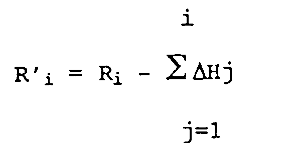
- R ' i satisfies the following linear equation: (1)
- R ' i 2 - R 0 2 + Ki aiX + biY + ciZ + diH 0 or ai, bi, ci, di and Ki are parameters that unit 4 calculates and which are a function of the coordinates of points P i and P 0 .
- Equation (1) with ai, bi, ci, di respectively equal to 2 (X i - X 0 ), 2 (Y i -Y 0 ), 2 (Z i - Z 0 ), 2 (R ' i - R 0 ), Ki being equal to X 0 2 - X i 2 + Y 0 2 -Y i 2 + Z 0 2 - Z i 2 .
- equation (1) is a linear expression in X, Y, Z, H 0 which it is possible to solve as soon as we have the measures at four points P i distinct from point P 0 .
- the solution obtained is validated when the noise of the three unknowns X, Y, Z is less than a predetermined threshold depending on the precision required for the work to be performed (in practice 1 to a few cm).
- the convergence time of the solution is a function of the observation geometry of the pseudolite and varies from 1 to a few minutes.
- the method and the device which have just been described make it possible to determine the position of a point at which reception of satellite signals is impossible, by using only radiolocation techniques.
- the determination of the objective point can be done during a free evolution of the mobile receiver, without any constraint of initial positioning or at relay points.
- the determination of the coordinates of the objective point can be done simultaneously with a survey or a layout classic in other respects.
- the process can be activated or interrupted without disturbing the normal functioning of the real time kinematics at these points.
- the link between the pseudolite transmitter and the mobile receiver can be temporarily interrupted, for example by masking, without this having any consequence on the quality of the result.
- the system accumulates and processes the time measurements necessary to obtain a result according to precision criteria which have been previously determined by the operator.
Abstract
Description
La présente invention est relative aux procédés et systèmes pour la localisation radio-satellitaire de points à la surface de la terre.The present invention relates to methods and systems for radio-satellite location of points on the earth's surface.
L'utilisation des signaux radioélectriques transmis par les satellites a trouvé, depuis une dizaine d'années, un vaste champ d'applications dans les domaines de la navigation, de la géodésie et de la topographie.The use of radio signals transmitted by satellites has found, over the past ten years, a wide field of applications in the fields of navigation, geodesy and topography.
Particulièrement, le système GPS (Global Positionning System selon la terminologie anglosaxonne), mondialement utilisé, permet désormais d'accéder, en temps réel, à des précisions centimétriques pour la détermination de points à la surface du globe. Ces grandes précisions sont indispensables pour les topographes dans un grand nombre d'applications de positionnement terrestre.In particular, the globally used GPS (Global Positioning System according to Anglo-Saxon terminology) system now provides real-time access to centimetric precision for the determination of points on the surface of the globe. These great details are essential for topographers in a large number of land positioning applications.
Les techniques mises en oeuvre pour parvenir à ce résultat sont dites de "cinématique temps réel". Elles sont utilisées depuis les années 1993-94 et illustrées en particulier dans le brevet français déposée par la demanderesse sous le n° 94-00523.The techniques used to achieve this result are called "real time kinematics". They have been used since 1993-94 and illustrated in particular in the French patent filed by the plaintiff under the number 94-00523.
On pourra également, pour une présentation générale de ces techniques, se référer à la publication " GPS Vermessung mit Real-Time-Kinematic Technische Untersicht " - VERWENDUNGEN & TECHNISCHE ANGABEN, B 1-7, TRIMBLE-1993.We can also, for a general presentation of these techniques, refer to the publication "GPS Vermessung mit Real-Time-Kinematic Technische Untersicht" - VERWENDUNGEN & TECHNISCHE ANGABEN, B 1-7, TRIMBLE-1993.
A l'aide de ces techniques, il est possible, sous la seule contrainte de recevoir simultanément les signaux en provenance d'au moins cinq satellites, d'assurer un travail de qualité et d'atteindre des précisions de détermination de l'ordre du centimètre pour le lever ou l'implantation de points. Par conséquent, les techniques de radiolocalisation satellitaire sont, dans de nombreuses applications, substituées aux techniques de localisation antérieures qui utilisaient des appareillages optiques pour la mesure d'angles ou de distances (distancemètre et tachéomètre).Using these techniques, it is possible, under the sole constraint of simultaneously receiving the signals from at least five satellites, to ensure quality work and to achieve accuracy of determination of the order of centimeter for raising or staking out points. Consequently, satellite radiolocation techniques are, in many applications, substituted for previous location techniques which used optical devices for the measurement of angles or distances (distance meter and tacheometer).
Toutefois, certains points au sol ne sont pas toujours suffisamment dégagés ou convenablement situés pour permettre une réception correcte des signaux en provenance des satellites. Ceci constitue un frein au développement des techniques de radiolocalisation satellitaire et notamment à leur utilisation par les géomètres pour leurs opérations les plus courantes.However, certain points on the ground are not always sufficiently clear or suitably located to allow correct reception of signals from the satellites. This is an obstacle to the development of satellite radiolocation techniques and in particular to their use by surveyors for their most common operations.
Cette limitation apparaît clairement lorsqu'il s'agit de déterminer la position d'un point sous couvert végétal, à l'aplomb d'un mur, sous un pont ou une trémie, et de façon plus générale, dans les environnements peu propices à la réception correcte des signaux satellitaires.This limitation appears clearly when it comes to determining the position of a point under plant cover, plumb with a wall, under a bridge or a hopper, and more generally, in environments unfavorable to correct reception of satellite signals.
La solution apportée à ce jour à ce type de situation consiste à déterminer, avec toute la précision requise, les coordonnées d'un ou plusieurs points dits "intermédiaires" situés dans un environnement dégagé, à proximité du point objectif masqué, puis à utiliser des techniques classiques de mesure d'angles et de distances (chaîne d'arpenteur, tachéomètre, distancemètre, etc) pour situer le point objectif par rapport à ces points intermédiaires.The solution brought to date to this type of situation consists in determining, with all the required precision, the coordinates of one or more so-called "intermediate" points located in a clear environment, near the masked objective point, then using classic techniques for measuring angles and distances (surveyor's chain, tacheometer, distance meter, etc.) to locate the objective point in relation to these intermediate points.
Cette association de techniques disparates rend les matériels lourds, les procédures complexes et les risques d'erreurs importants ; en pratique, elle limite considérablement l'intérêt que présente l'utilisation des techniques satellitaires, puisque de toute façon les techniques classiques et les matériels associés restent indispensables dans de très nombreuses applications.This combination of disparate techniques makes heavy equipment, complex procedures and the risk of significant errors; in practice, it considerably limits the interest presented by the use of satellite techniques, since in any case the conventional techniques and the associated materials remain essential in very numerous applications.
Un but de l'invention est d'accroître considérablement le champ d'application des techniques radio-satellitaires. Elle propose à cet effet une méthode et un système de radiolocalisation basées sur l'exploitation des signaux satellitaires, qui permettent d'accéder à la position précise des points masqués sur lesquels la réception des signaux radio-satellitaires est impossible ou insuffisante.An object of the invention is to considerably increase the field of application of radio-satellite techniques. To this end, it proposes a radiolocation method and system based on the exploitation of satellite signals, which allow to access the precise position of the masked points on which the reception of radio-satellite signals is impossible or insufficient.
Selon le procédé proposé par l'invention :
- on positionne l'antenne d'un mobile de radiolocalisation évoluant librement à proximité du point masqué sur une pluralité de points quelconques où la réception des signaux émis par les satellites est suffisante,
- on détermine par radiolocalisation les coordonnées de ces points et
- on détermine en fonction de ces coordonnées les coordonnées du point masqué,
- on dispose un émetteur pseudolite sur le point masqué,
- on mesure en chacun des points où l'antenne est successivement positionnée la phase du signal émis par l'émetteur pseudolite et reçu en ces points par ladite antenne,
- on détermine en fonction de ces mesures et des coordonnées de ces points les coordonnées du point masqué.
- the antenna of a radiolocation mobile moving freely is positioned near the masked point on any plurality of points where the reception of the signals transmitted by the satellites is sufficient,
- the coordinates of these points are determined by radiolocation
- the coordinates of the masked point are determined as a function of these coordinates,
- we have a pseudolite transmitter on the masked point,
- the phase of the signal emitted by the pseudolite transmitter and received at these points by said antenna is measured at each of the points where the antenna is successively positioned,
- the coordinates of the masked point are determined as a function of these measurements and of the coordinates of these points.
Ainsi selon l'invention, on exploite les mesures de phase du signal émis par l'émetteur pseudolite et les mesures issues des satellites permettant de calculer les positions successives du mobile localisateur, pour calculer les coordonnées du point masqué.Thus according to the invention, the phase measurements of the signal emitted by the pseudolite transmitter and the measurements from the satellites are used to calculate the successive positions of the locating mobile, to calculate the coordinates of the masked point.
On rappelle ici qu'un "pseudolite" ou "pseudo-satellite" est une unité d'émission au sol qui émet des signaux radioélectriques à codage pseudo-aléatoire qui sont analogues à ceux émis par les satellites du système de radiolocalisation utilisé (satellites de la constellation NAVSTAR pour les systèmes GPS).It is recalled here that a "pseudolite" or "pseudo-satellite" is a ground transmission unit which transmits radio signals with pseudo-random coding which are analogous to those transmitted by the satellites of the radiolocation system used (satellites of the NAVSTAR constellation for GPS systems).
Les pseudolites sont classiquement connus de l'Homme du Métier.Pseudolites are classically known to those skilled in the art.
Ils sont principalement utilisés dans le domaine de l'aéronautique pour le guidage d'avions par rapport à des aires d'atterrissage ou pour la levée d'ambiguïtés d'entiers de phase.They are mainly used in the aeronautical field for guiding aircraft in relation to landing areas or for removing ambiguities from integers of a phase.
On pourra avantageusement à cet égard se référer aux brevets US-5.177.489 et US-5.311.194 et aux publications suivantes :
- Real time flight testing using integrity beacons for GPS, category III Precison Landing, CLARK COHEN and al. - Revue Navigation Vol. 41 N°2 - Summer 94 - Institute of Navigation,
- Integrity Monitoring for precision approach using Kinematic GPS and a ground-based pseudolite - Boris PERVAN and al. - Revue Navigation - Vol. 41 n°2 - Summer 94.
- Real time flight testing using integrity beacons for GPS, category III Precison Landing, CLARK COHEN and al. - Revue Navigation Vol. 41 N ° 2 - Summer 94 - Institute of Navigation,
- Integrity Monitoring for precision approach using Kinematic GPS and a ground-based pseudolite - Boris PERVAN and al. - Navigation Review - Vol. 41 n ° 2 - Summer 94.
Notamment, dans une variante avantageuse du procédé conforme à l'invention :
- pour chaque point où l'antenne est successivement positionnée, on détermine les paramètres d'une équation linéaire reliant les coordonnées du point masqué et le déphasage entre l'émetteur pseudolite et le mobile de radiolocalisation en un instant de référence, ces paramètres étant fonction de la mesure de la phase du signal pseudolite et des coordonnées de ces points,
- on détermine les coordonnées du point masqué par résolution des équations linéaires ainsi obtenues.
- for each point where the antenna is successively positioned, the parameters of a linear equation are determined connecting the coordinates of the masked point and the phase shift between the pseudolite transmitter and the radiolocation mobile in a reference instant, these parameters being a function of measuring the phase of the pseudolite signal and the coordinates of these points,
- the coordinates of the masked point are determined by solving the linear equations thus obtained.
Selon l'invention, il est également proposé un dispositif qui comporte un émetteur pseudolite destiné à être placé sur un point à localiser où la réception des signaux émis par les satellites n'est pas suffisante, l'un des canaux des moyens de radiolocalisation, habituellement dédié à la réception des signaux radio-satellitaires, étant affecté à la réception du signal émis par l'émetteur peusdolite, ce dispositif comportant des moyens de traitement permettant de déterminer les coordonnées du point à localiser en fonction de la mesure de la phase du signal émis par l'émetteur pseudolite en différents points où l'antenne est successivement positionnée et des coordonnées de ces points déterminées par l'unité.According to the invention, a device is also proposed which comprises a pseudolite transmitter intended to be placed on a point to be located where the reception of the signals transmitted by the satellites is not sufficient, one of the channels of the radiolocation means, usually dedicated to the reception of radio-satellite signals, being assigned to the reception of the signal emitted by the peusdolite transmitter, this device comprising processing means making it possible to determine the coordinates of the point to be located according to the measurement of the phase of the signal emitted by the pseudolite transmitter at different points where the antenna is successively positioned and the coordinates of these points determined by the unit.
D'autres caractéristiques et avantages ressortiront encore de la description qui suit. Cette description est purement illustrative et non limitative. Elle doit être lue en regard du dessin unique annexé sur lequel on a illustré schématiquement le principe de la méthode et du système proposé par l'invention.Other characteristics and advantages will emerge from the description which follows. This description is purely illustrative and not limiting. It must be read with reference to the single appended drawing in which the principle of the method and of the system proposed by the invention has been schematically illustrated.
Sur cette figure, on a représenté un point masqué P dont on cherche à relever les coordonnées, qui est situé dans une zone couverte Zc dans laquelle les signaux S radio-satellitaires ne sont pas convenablement reçus.In this figure, a masked point P is shown, the coordinates of which are sought to be noted, which is situated in a covered area Zc in which the radio-satellite signals S are not properly received.
Le dispositif utilisé pour relever les coordonnées XYZ de ce point P comporte un émetteur pseudolite 1 et un mobile 2 de radiolocalisation G.P.S. .The device used to take the XYZ coordinates of this point P comprises a pseudolite transmitter 1 and a mobile 2 for radiolocation G.P.S. .
Le pseudolite 1 rayonne à une très faible puissance (quelques microwatts), à la fréquence GPS de 1,57542 GHz (L1), ou à une fréquence légèrement décalée, un signal Sp modulé en phase par un code pseudoaléatoire dont le format est celui des codes GPS.Pseudolite 1 radiates at a very low power (a few microwatts), at the GPS frequency of 1.57542 GHz (L1), or at a slightly offset frequency, a signal S p modulated in phase by a pseudo-random code whose format is that GPS codes.
Le mobile 2 comporte une antenne de réception 3 montée sur une canne tenue par l'opérateur et une unité de traitement 4 portée par l'opérateur et reliée à ladite antenne 3.The mobile 2 includes a receiving
L'unité 4 traite les signaux radioélectriques reçus par l'antenne 3 en provenance des satellites GPS, du pseudolite 1, ainsi que d'une balise 5 de référence qui reçoit également les signaux en provenance des satellites GPS et qui retransmet des signaux de correction différentielle de phase (signaux SB sur la figure).The
Comme on l'aura compris, l'un des canaux du mobile de radiolocalisation 2, habituellement dédié à la réception des signaux radio-satellitaires, est affecté à la réception du signal SP émis par le pseudolite 1, de sorte que l'unité 4 dispose d'une mesure de phase qui est fonction de la distance entre le récepteur mobile que constitue le mobile 2 et l'émetteur pseudolite 1.As will be understood, one of the channels of the radiolocation mobile 2, usually dedicated to the reception of radio-satellite signals, is assigned to the reception of the signal S P emitted by pseudolite 1, of so that the
Les traitements que l'unité 4 réalise sur les signaux GPS sont des traitements cinématiques en temps réels, de sorte que la position de l'antenne est connue avec une précision centimétrique. Ces traitements sont par exemple des traitements du type de ceux décrits dans la demande de brevet français déposée par la demanderesse sous le numéro 94-00.523, à laquelle on pourra avantageusement se reporter.The treatments that the
L'opérateur déplace l'antenne 3 du récepteur mobile 2 sur une succession de points Pi où les signaux radio-satellitaires S sont convenablement reçus.The operator moves the
En chacun de ces différents points Pi, le récepteur 2 détermine les coordonnées Xi, Yi, Zi du point Pi sur lequel il se trouve et réalise une mesure de phase Ri sur le signal émis par le pseudolite 1 et reçu par le récepteur GPS 2.At each of these different points P i , the
La connaissance des coordonnées d'au moins quatre points Pi et des mesures de phase Ri correspondantes permet à l'unité 4 de déterminer les coordonnées X, Y et Z du point P.Knowing the coordinates of at least four points Pi and the corresponding phase measurements R i allows the
Les traitements mis en oeuvre à cet effet par l'unité 4 vont maintenant être explicités.The treatments implemented for this purpose by the
Au point P0, de coordonnées X0, Y0, Z0, la mesure de phase est :![]()
![]()
En un temps T1 ultérieur, l'opérateur s'est déplacé en un point P1 de coordonnées X1, Y1, Z1 et la mesure de phase que réalise le récepteur 2 est :![]()
![]()
En un temps T2, l'opérateur s'est déplacé en un point P2 de coordonnées X2, Y2, Z2. La mesure de phase qu'il réalise est :![]()
![]()
Il poursuit ses mesures sur plusieurs points Pi, la mesure de phase en un point Pi donné étant :
Les évolutions ΔHi sont calculées par l'unité 4 par soustraction des évolutions d'horloge ΔHi(2-5) entre le récepteur 2 et la balise 5 et ΔHi(5-1) entre la balise 5 et le pseudolite 1.The ΔHi changes are calculated by the
La valeur de l'évolution ΔHi(2-5) est calculée par l'unité 4 et est un sous-produit de la détermination des coordonnées du point Pi.The value of the evolution ΔHi (2-5) is calculated by the
La deuxième de ces évolutions ΔHi(5-1) peut être connue de deux façons :
- Si la balise 5 se trouve en vue du pseudolite 1, on peut lui affecter de la même façon que pour le récepteur 2 un canal spécifique pour la réception des signaux émis du pseudolite 1. La distance entre la balise 5 et le pseudolite 1 étant constante, l'évolution de phase mesurée par la balise 5 sur le signal émis du pseudolite 1 correspond à l'évolution relative des horloges des deux éléments. Cette information est transmise par la balise 5
au récepteur 2 ; - Si la balise 5 se trouve hors de portée du pseudolite 1, la solution consiste à asservir l'évolution de l'horloge du pseudolite 1 à celle de la balise 5. De la sorte, les termes ΔHi(2-5) sont tous nuls et il reste ΔHi(1-2) = ΔHi(1-5). Etant situé à proximité du récepteur mobile 2, le pseudolite 1 reçoit les émissions de la balise 5 de la même façon que le mobile 2. Il suffit alors, pour réaliser l'asservissement, de moduler la porteuse émise par la balise 5 par une fréquence sous multiple de son horloge, et de doter le pseudolite 1 des moyens de réception et de décodage de cette information. Les techniques d'asservissement d'une horloge sur une autre par liaison herzienne sont parfaitemment connues de l'Homme du Métier.
- If the
beacon 5 is in view of the pseudolite 1, it can be assigned in the same way as for the receiver 2 a specific channel for the reception of the signals transmitted from the pseudolite 1. The distance between thebeacon 5 and the pseudolite 1 being constant , the phase evolution measured by thebeacon 5 on the signal emitted from the pseudolite 1 corresponds to the relative evolution of the clocks of the two elements. This information is transmitted by thebeacon 5 to thereceiver 2; - If the
tag 5 is out of range of the pseudolite 1, the solution consists in controlling the evolution of the clock of the pseudolite 1 to that of thetag 5. In this way, the terms ΔHi (2-5) are all zero and there remains ΔH i (1-2) = ΔH i (1-5) . Being located near themobile receiver 2, the pseudolite 1 receives the transmissions from thebeacon 5 in the same way as the mobile 2. It is then enough, to carry out the servoing, to modulate the carrier emitted by thebeacon 5 by a frequency under multiple of its clock, and to provide the pseudolite 1 with the means for receiving and decoding this information. The techniques of slaving from one clock to another by herzian link are perfectly known to those skilled in the art.
Chacune de ces deux solutions présente ses avantages propres. La première est rigoureuse, mais nécessite l'implantation de la balise 5 en vue du pseudolite 1, ce qui représente une contrainte opérationnelle. La seconde libère l'opérateur de cette contrainte mais au prix d'une petite dégradation de la précision, fonction de la qualité de la réalisation de l'asservissement.Each of these two solutions has its own advantages. The first is rigorous, but requires the establishment of the
Quoi qu'il en soit, l'unité 4 mémorise les valeurs successives des évolutions ΔHj et calcule en chaque point Pi (ième point) une valeur de phase Ri donnée par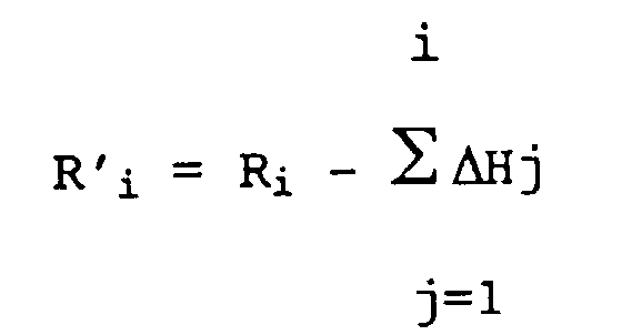
![]()
![]()
Cette valeur R'i vérifie l'équation linéaire suivante:![]()
ai, bi, ci, di et Ki sont des paramètres que l'unité 4 calcule et qui sont fonction des coordonnées des points Pi et P0.This value R ' i satisfies the following linear equation: ![]()
ai, bi, ci, di and Ki are parameters that
Entre Ti et T0 on a en effet :![]()

![]()
On retrouve donc l'équation (1) avec ai, bi, ci, di respectivement égaux à![]()
![]()
![]()
![]()
Comme on l'aura compris, l'équation (1) est une expression linéaire en X, Y, Z, H0 qu'il est possible de résoudre dès que l'on dispose des mesures en quatre points Pi distincts du point P0.As we will have understood, equation (1) is a linear expression in X, Y, Z, H 0 which it is possible to solve as soon as we have the measures at four points P i distinct from point P 0 .
En pratique, on utilise la méthode des moindres carrés et on réalise sur les valeurs X, Y, Z successivement déterminées pour un même point P un test de stabilité et l'on arrête les mesures lorsque la stabilité des valeurs de ces coordonnées X, Y, Z est satisfaisante.In practice, we use the method of least squares and we carry out on the values X, Y, Z successively determined for the same point P a stability test and we stop the measurements when the stability of the values of these coordinates X, Y , Z is satisfactory.
Par exemple, la solution obtenue est validée lorsque le bruit des trois inconnues X, Y, Z est inférieur à un seuil prédéterminé fonction de la précision requise pour le travail à effectuer (en pratique 1 à quelques cm).For example, the solution obtained is validated when the noise of the three unknowns X, Y, Z is less than a predetermined threshold depending on the precision required for the work to be performed (in practice 1 to a few cm).
Le temps de convergence de la solution est fonction de la géomètrie d'observation du pseudolite et varie de 1 à quelques minutes.The convergence time of the solution is a function of the observation geometry of the pseudolite and varies from 1 to a few minutes.
Comme on l'aura compris, le procédé et le dispositif qui viennent d'être décrits permettent de déterminer la position d'un point sur lequel la réception des signaux satellitaires est impossible, en ne mettant en oeuvre que des techniques de radiolocalisation.As will be understood, the method and the device which have just been described make it possible to determine the position of a point at which reception of satellite signals is impossible, by using only radiolocation techniques.
Toutes les mesures sont faites en un seul point (à savoir le centre de phase de l'antenne 3), ce qui élimine les problèmes de raccordement entre mesures issues de différents systèmes ou capteurs.All the measurements are made at a single point (namely the phase center of the antenna 3), which eliminates the problems of connection between measurements from different systems or sensors.
On notera que les traitements qui viennent d'être décrits s'effectuent à partir d'observations sur les variations de phase des signaux reçus, et non sur la phase de ces signaux, ce qui élimine les problèmes liés à la détermination des entiers de phase.It will be noted that the processing operations which have just been described are carried out on the basis of observations on the phase variations of the signals received, and not on the phase of these signals, which eliminates the problems linked to the determination of the integers of phase .
Sur le plan opérationnel, le procédé et le système conforme à l'invention présentent de nombreux avantages.Operationally, the method and the system according to the invention have numerous advantages.
La détermination du point objectif peut se faire au cours d'une libre évolution du récepteur mobile, sans aucune contrainte de positionnement initial ou en des points relais.The determination of the objective point can be done during a free evolution of the mobile receiver, without any constraint of initial positioning or at relay points.
La détermination des coordonnées du point objectif peut se faire simultanément à un levé ou une implantation classique en d'autres points.The determination of the coordinates of the objective point can be done simultaneously with a survey or a layout classic in other respects.
Le procédé peut être activé ou interrompu sans perturber le fonctionnement normal de la cinématique temps réel en ces points.The process can be activated or interrupted without disturbing the normal functioning of the real time kinematics at these points.
La liaison entre l'émetteur pseudolite et le récepteur mobile peut être momentanément interrompue, par exemple par masquage, sans qu'il n'en résulte aucune conséquence sur la qualité du résultat.The link between the pseudolite transmitter and the mobile receiver can be temporarily interrupted, for example by masking, without this having any consequence on the quality of the result.
Le système accumule et traite les mesures de temps nécessaire à l'obtention d'un résultat selon des critères de précision qui ont été préalablement déterminés par l'opérateur.The system accumulates and processes the time measurements necessary to obtain a result according to precision criteria which have been previously determined by the operator.
Lorsque la qualité requise est obtenue, le calcul se termine automatiquement et l'opérateur en est averti par l'unité 4.When the required quality is obtained, the calculation ends automatically and the operator is notified by
On notera également que le système proposé par l'invention est d'une grande simplicité de manipulation : hormi la mise en place de l'émetteur pseudolite, aucune autre manipulation n'est nécessaire.It will also be noted that the system proposed by the invention is very simple to handle: apart from the installation of the pseudolite transmitter, no other manipulation is necessary.
Claims (12)

Applications Claiming Priority (2)
| Application Number | Priority Date | Filing Date | Title |
|---|---|---|---|
| FR9506646A FR2735240B1 (en) | 1995-06-06 | 1995-06-06 | METHOD AND DEVICE FOR THE PRECISE DETERMINATION OF A MASK POINT BY SATELLITE RADIOLOCATION. |
| FR9506646 | 1995-06-06 |
Publications (2)
| Publication Number | Publication Date |
|---|---|
| EP0747721A1 true EP0747721A1 (en) | 1996-12-11 |
| EP0747721B1 EP0747721B1 (en) | 2001-09-05 |
Family
ID=9479662
Family Applications (1)
| Application Number | Title | Priority Date | Filing Date |
|---|---|---|---|
| EP96401195A Expired - Lifetime EP0747721B1 (en) | 1995-06-06 | 1996-06-05 | Method and device for precisely determining an electromagnetically shielded point by position measuring with satellites |
Country Status (4)
| Country | Link |
|---|---|
| US (1) | US5757314A (en) |
| EP (1) | EP0747721B1 (en) |
| DE (1) | DE69614927T2 (en) |
| FR (1) | FR2735240B1 (en) |
Cited By (5)
| Publication number | Priority date | Publication date | Assignee | Title |
|---|---|---|---|---|
| EP1999481A1 (en) * | 2006-03-30 | 2008-12-10 | Novatel, Inc. | Enhancement of gnss position determination in poor signal propagation environments |
| US8055288B2 (en) | 2007-11-02 | 2011-11-08 | Novatel Inc. | System and method for distributing accurate time and frequency over a network |
| US8085201B2 (en) | 2007-11-13 | 2011-12-27 | Novatel Inc. | System for determining position over a network |
| US8159397B2 (en) | 2006-03-30 | 2012-04-17 | Novatel Inc. | System for determining position using two way time transfer signals |
| US8558738B2 (en) | 2008-05-22 | 2013-10-15 | Novatel Inc. | GNSS receiver using signals of opportunity and assistance information to reduce the time to first fix |
Families Citing this family (23)
| Publication number | Priority date | Publication date | Assignee | Title |
|---|---|---|---|---|
| US5896924A (en) * | 1997-03-06 | 1999-04-27 | Baker Hughes Incorporated | Computer controlled gas lift system |
| US6101178A (en) | 1997-07-10 | 2000-08-08 | Ksi Inc. | Pseudolite-augmented GPS for locating wireless telephones |
| US6100842A (en) * | 1998-02-20 | 2000-08-08 | Trimble Navigation Limited | Chained location determination system |
| US8446321B2 (en) | 1999-03-05 | 2013-05-21 | Omnipol A.S. | Deployable intelligence and tracking system for homeland security and search and rescue |
| US7570214B2 (en) | 1999-03-05 | 2009-08-04 | Era Systems, Inc. | Method and apparatus for ADS-B validation, active and passive multilateration, and elliptical surviellance |
| US7667647B2 (en) | 1999-03-05 | 2010-02-23 | Era Systems Corporation | Extension of aircraft tracking and positive identification from movement areas into non-movement areas |
| US7739167B2 (en) | 1999-03-05 | 2010-06-15 | Era Systems Corporation | Automated management of airport revenues |
| US8203486B1 (en) | 1999-03-05 | 2012-06-19 | Omnipol A.S. | Transmitter independent techniques to extend the performance of passive coherent location |
| US7889133B2 (en) | 1999-03-05 | 2011-02-15 | Itt Manufacturing Enterprises, Inc. | Multilateration enhancements for noise and operations management |
| GB9920286D0 (en) * | 1999-08-27 | 1999-10-27 | Roke Manor Research | Improvements in or relating to satellite navigation |
| US7099796B2 (en) * | 2001-10-22 | 2006-08-29 | Honeywell International Inc. | Multi-sensor information fusion technique |
| US7427146B2 (en) * | 2004-02-11 | 2008-09-23 | 3M Innovative Properties Company | Light-collecting illumination system |
| US7339526B2 (en) * | 2004-07-30 | 2008-03-04 | Novariant, Inc. | Synchronizing ranging signals in an asynchronous ranging or position system |
| US7315278B1 (en) * | 2004-07-30 | 2008-01-01 | Novariant, Inc. | Multiple frequency antenna structures and methods for receiving navigation or ranging signals |
| US7342538B2 (en) * | 2004-07-30 | 2008-03-11 | Novariant, Inc. | Asynchronous local position determination system and method |
| US7205939B2 (en) * | 2004-07-30 | 2007-04-17 | Novariant, Inc. | Land-based transmitter position determination |
| US7532160B1 (en) * | 2004-07-30 | 2009-05-12 | Novariant, Inc. | Distributed radio frequency ranging signal receiver for navigation or position determination |
| US7271766B2 (en) * | 2004-07-30 | 2007-09-18 | Novariant, Inc. | Satellite and local system position determination |
| US7339525B2 (en) * | 2004-07-30 | 2008-03-04 | Novariant, Inc. | Land-based local ranging signal methods and systems |
| US7339524B2 (en) * | 2004-07-30 | 2008-03-04 | Novariant, Inc. | Analog decorrelation of ranging signals |
| US7965227B2 (en) | 2006-05-08 | 2011-06-21 | Era Systems, Inc. | Aircraft tracking using low cost tagging as a discriminator |
| US8983685B2 (en) * | 2010-07-30 | 2015-03-17 | Deere & Company | System and method for moving-base RTK measurements |
| EP2511658A1 (en) * | 2011-04-14 | 2012-10-17 | Hexagon Technology Center GmbH | Measuring system and method for new point determination |
Citations (8)
| Publication number | Priority date | Publication date | Assignee | Title |
|---|---|---|---|---|
| WO1990000719A1 (en) * | 1988-07-06 | 1990-01-25 | Wild Leitz Ag | Surveying system with an electro-optical total station and a mobile receiver station of a satellite positioning system |
| WO1990000718A1 (en) * | 1988-07-06 | 1990-01-25 | Wild Leitz Ag | Surveying instrument with receiver for a satellite position measurement system and process for operating it |
| EP0420338A2 (en) * | 1989-09-26 | 1991-04-03 | Magnavox Electronic Systems Company | Method and apparatus for precision attitude determination and kinematic positioning |
| EP0481307A2 (en) * | 1990-10-15 | 1992-04-22 | Asahi Seimitsu Kabushiki Kaisha | Surveying method utilizing global positioning system and surveying equipment used to perform this method |
| US5177489A (en) * | 1989-09-26 | 1993-01-05 | Magnavox Electronic Systems Company | Pseudolite-aided method for precision kinematic positioning |
| EP0588598A1 (en) * | 1992-09-15 | 1994-03-23 | Navsys Corporation | GPS precision approach and landing system for aircraft |
| US5379045A (en) * | 1993-09-01 | 1995-01-03 | Trimble Navigation Limited | SATPS mapping with angle orientation calibrator |
| JPH07260480A (en) * | 1994-03-22 | 1995-10-13 | Sokkia Co Ltd | Survey device |
Family Cites Families (3)
| Publication number | Priority date | Publication date | Assignee | Title |
|---|---|---|---|---|
| US5153598A (en) * | 1991-09-26 | 1992-10-06 | Alves Jr Daniel F | Global Positioning System telecommand link |
| US5452211A (en) * | 1992-08-10 | 1995-09-19 | Caterpillar Inc. | Method and system for determining vehicle position |
| US5548293A (en) * | 1993-03-24 | 1996-08-20 | Leland Stanford Junior University | System and method for generating attitude determinations using GPS |
-
1995
- 1995-06-06 FR FR9506646A patent/FR2735240B1/en not_active Expired - Lifetime
-
1996
- 1996-06-05 DE DE69614927T patent/DE69614927T2/en not_active Expired - Lifetime
- 1996-06-05 EP EP96401195A patent/EP0747721B1/en not_active Expired - Lifetime
- 1996-06-06 US US08/660,533 patent/US5757314A/en not_active Expired - Lifetime
Patent Citations (9)
| Publication number | Priority date | Publication date | Assignee | Title |
|---|---|---|---|---|
| WO1990000719A1 (en) * | 1988-07-06 | 1990-01-25 | Wild Leitz Ag | Surveying system with an electro-optical total station and a mobile receiver station of a satellite positioning system |
| WO1990000718A1 (en) * | 1988-07-06 | 1990-01-25 | Wild Leitz Ag | Surveying instrument with receiver for a satellite position measurement system and process for operating it |
| EP0420338A2 (en) * | 1989-09-26 | 1991-04-03 | Magnavox Electronic Systems Company | Method and apparatus for precision attitude determination and kinematic positioning |
| US5177489A (en) * | 1989-09-26 | 1993-01-05 | Magnavox Electronic Systems Company | Pseudolite-aided method for precision kinematic positioning |
| EP0481307A2 (en) * | 1990-10-15 | 1992-04-22 | Asahi Seimitsu Kabushiki Kaisha | Surveying method utilizing global positioning system and surveying equipment used to perform this method |
| EP0588598A1 (en) * | 1992-09-15 | 1994-03-23 | Navsys Corporation | GPS precision approach and landing system for aircraft |
| US5311194A (en) * | 1992-09-15 | 1994-05-10 | Navsys Corporation | GPS precision approach and landing system for aircraft |
| US5379045A (en) * | 1993-09-01 | 1995-01-03 | Trimble Navigation Limited | SATPS mapping with angle orientation calibrator |
| JPH07260480A (en) * | 1994-03-22 | 1995-10-13 | Sokkia Co Ltd | Survey device |
Non-Patent Citations (1)
| Title |
|---|
| PATENT ABSTRACTS OF JAPAN vol. 96, no. 2 29 February 1996 (1996-02-29) * |
Cited By (6)
| Publication number | Priority date | Publication date | Assignee | Title |
|---|---|---|---|---|
| EP1999481A1 (en) * | 2006-03-30 | 2008-12-10 | Novatel, Inc. | Enhancement of gnss position determination in poor signal propagation environments |
| EP1999481A4 (en) * | 2006-03-30 | 2010-11-24 | Novatel Inc | Enhancement of gnss position determination in poor signal propagation environments |
| US8159397B2 (en) | 2006-03-30 | 2012-04-17 | Novatel Inc. | System for determining position using two way time transfer signals |
| US8055288B2 (en) | 2007-11-02 | 2011-11-08 | Novatel Inc. | System and method for distributing accurate time and frequency over a network |
| US8085201B2 (en) | 2007-11-13 | 2011-12-27 | Novatel Inc. | System for determining position over a network |
| US8558738B2 (en) | 2008-05-22 | 2013-10-15 | Novatel Inc. | GNSS receiver using signals of opportunity and assistance information to reduce the time to first fix |
Also Published As
| Publication number | Publication date |
|---|---|
| FR2735240B1 (en) | 1998-01-30 |
| DE69614927T2 (en) | 2002-04-11 |
| FR2735240A1 (en) | 1996-12-13 |
| EP0747721B1 (en) | 2001-09-05 |
| US5757314A (en) | 1998-05-26 |
| DE69614927D1 (en) | 2001-10-11 |
Similar Documents
| Publication | Publication Date | Title |
|---|---|---|
| EP0747721B1 (en) | Method and device for precisely determining an electromagnetically shielded point by position measuring with satellites | |
| EP0283353B1 (en) | Landing aid system using navigation satellites | |
| US5949371A (en) | Laser based reflectors for GPS positioning augmentation | |
| EP2353024B1 (en) | Method for geolocating an object by multitelemetry | |
| EP1712930B1 (en) | System and procedure for determining the instantaneous speed of an object | |
| CA2615042C (en) | Method and device for determining the ground position of a mobile object, in particular an aircraft on an airport | |
| EP2902797A1 (en) | Radio-frequency method and system for determining, using spacecraft torque, the relative angular position between a plurality of remote spacecraft | |
| US6138074A (en) | Monitoring station location determination for a satellite navigation system | |
| GB2273408A (en) | Satellite navigation for vehicles | |
| EP2921923A1 (en) | Method for tracking a transfer orbit or a phase of placing a space vehicle in orbit, in particular a vehicle with electric drive, and apparatus for implementing such a method | |
| FR2959571A1 (en) | DISTRIBUTED DISTANCE MEASUREMENT SYSTEM FOR LOCATING A GEOSTATIONARY SATELLITE. | |
| EP0327447A1 (en) | Radio navigation system | |
| EP2318858B1 (en) | Improvement to the locating of aircraft by a primary radar by utilizing a secondary radar in s mode | |
| EP1281093B1 (en) | Method and device for instantaneous determination of orientation, based on satellite positioning signals | |
| US6259403B1 (en) | GPS positioning utilizing laser based reflectors augmentation | |
| FR2976087B1 (en) | SYSTEM FOR THE GEOGRAPHICAL LOCATION OF A RADIO SIGNAL TRANSMITTER LOCATED AT THE SURFACE OF THE EARTH AND ASSOCIATED METHOD OF DISTRIBUTED INTERFEROMETRY | |
| US6104339A (en) | All-terrain error correction | |
| WO2007010047A1 (en) | Positioning method, device and system using multi-source synchronous pulsed relay | |
| WO2011039457A1 (en) | Method and device for dynamically locating a moving body | |
| FR3040792A1 (en) | USEFUL CHARGE OF A SATELLITE OF MEASUREMENT OF A LOCATION SYSTEM AND METHOD OF LOCALIZATION | |
| US20230367021A1 (en) | Method and System for Determining a Phase of a GNSS Carrier | |
| EP1459979A1 (en) | Method and device for determining at least one information regarding the vertical position of an aircraft | |
| EP2626725B1 (en) | Method for determining a confidence indicator relating to the path taken by a mobile | |
| FR3079608A1 (en) | METHOD FOR GEOLOCATING A DRONE, GEOLOCATION SYSTEM AND COMPUTER PROGRAM PRODUCT THEREOF | |
| FR2715230A1 (en) | Real time precision location of mobile on earth's surface by gps |
Legal Events
| Date | Code | Title | Description |
|---|---|---|---|
| PUAI | Public reference made under article 153(3) epc to a published international application that has entered the european phase |
Free format text: ORIGINAL CODE: 0009012 |
|
| AK | Designated contracting states |
Kind code of ref document: A1 Designated state(s): BE DE FR GB NL |
|
| 17P | Request for examination filed |
Effective date: 19970526 |
|
| 17Q | First examination report despatched |
Effective date: 20000117 |
|
| GRAG | Despatch of communication of intention to grant |
Free format text: ORIGINAL CODE: EPIDOS AGRA |
|
| GRAG | Despatch of communication of intention to grant |
Free format text: ORIGINAL CODE: EPIDOS AGRA |
|
| GRAH | Despatch of communication of intention to grant a patent |
Free format text: ORIGINAL CODE: EPIDOS IGRA |
|
| GRAH | Despatch of communication of intention to grant a patent |
Free format text: ORIGINAL CODE: EPIDOS IGRA |
|
| RAP1 | Party data changed (applicant data changed or rights of an application transferred) |
Owner name: DASSAULT SERCEL NAVIGATION-POSITIONNEMENT |
|
| GRAA | (expected) grant |
Free format text: ORIGINAL CODE: 0009210 |
|
| AK | Designated contracting states |
Kind code of ref document: B1 Designated state(s): BE DE FR GB NL |
|
| REF | Corresponds to: |
Ref document number: 69614927 Country of ref document: DE Date of ref document: 20011011 |
|
| GBT | Gb: translation of ep patent filed (gb section 77(6)(a)/1977) |
Effective date: 20011117 |
|
| REG | Reference to a national code |
Ref country code: GB Ref legal event code: IF02 |
|
| PLBE | No opposition filed within time limit |
Free format text: ORIGINAL CODE: 0009261 |
|
| STAA | Information on the status of an ep patent application or granted ep patent |
Free format text: STATUS: NO OPPOSITION FILED WITHIN TIME LIMIT |
|
| 26N | No opposition filed | ||
| BECA | Be: change of holder's address |
Owner name: MAGELLAN NAVIGATION S.P.A.S.ZAC DE LA FLEURIAYE, B Effective date: 20080114 |
|
| BECN | Be: change of holder's name |
Owner name: MAGELLAN NAVIGATION S.P.A.S.ZAC DE LA FLEURIAYE, B Effective date: 20080114 Owner name: MAGELLAN NAVIGATION S.P.A.S. Effective date: 20080114 |
|
| REG | Reference to a national code |
Ref country code: FR Ref legal event code: CJ Ref country code: FR Ref legal event code: CD Ref country code: FR Ref legal event code: CA |
|
| NLT1 | Nl: modifications of names registered in virtue of documents presented to the patent office pursuant to art. 16 a, paragraph 1 |
Owner name: THALES NAVIGATION S.A. Owner name: MAGELLAN NAVIGATION SAS Owner name: MAGELLAN NAVIGATION SA Owner name: DSNP |
|
| REG | Reference to a national code |
Ref country code: NL Ref legal event code: TD Effective date: 20101125 |
|
| BECH | Be: change of holder |
Owner name: MITAC INTERNATIONAL CORP Effective date: 20110106 |
|
| REG | Reference to a national code |
Ref country code: FR Ref legal event code: CD |
|
| REG | Reference to a national code |
Ref country code: GB Ref legal event code: 732E Free format text: REGISTERED BETWEEN 20110414 AND 20110420 |
|
| REG | Reference to a national code |
Ref country code: NL Ref legal event code: SD Effective date: 20110601 |
|
| REG | Reference to a national code |
Ref country code: DE Ref legal event code: R082 Ref document number: 69614927 Country of ref document: DE Representative=s name: PRINZ & PARTNER MBB PATENTANWAELTE RECHTSANWAE, DE Effective date: 20110725 Ref country code: DE Ref legal event code: R082 Ref document number: 69614927 Country of ref document: DE Representative=s name: PRINZ & PARTNER PATENTANWAELTE RECHTSANWAELTE, DE Effective date: 20110725 Ref country code: DE Ref legal event code: R081 Ref document number: 69614927 Country of ref document: DE Owner name: MITAC INTERNATIONAL CORP., KUEI-SHAN HSIANG, TW Free format text: FORMER OWNER: MAGELLAN NAVIGATION S.A.S., CARQUEFOU, FR Effective date: 20110725 Ref country code: DE Ref legal event code: R081 Ref document number: 69614927 Country of ref document: DE Owner name: MITAC INTERNATIONAL CORP., TW Free format text: FORMER OWNER: MAGELLAN NAVIGATION S.A.S., CARQUEFOU, FR Effective date: 20110725 |
|
| REG | Reference to a national code |
Ref country code: DE Ref legal event code: R082 Ref document number: 69614927 Country of ref document: DE Representative=s name: PRINZ & PARTNER PATENTANWAELTE RECHTSANWAELTE, DE |
|
| REG | Reference to a national code |
Ref country code: DE Ref legal event code: R082 Ref document number: 69614927 Country of ref document: DE Representative=s name: PRINZ & PARTNER MBB PATENTANWAELTE RECHTSANWAE, DE Effective date: 20111017 Ref country code: DE Ref legal event code: R082 Ref document number: 69614927 Country of ref document: DE Representative=s name: PRINZ & PARTNER PATENTANWAELTE RECHTSANWAELTE, DE Effective date: 20111017 Ref country code: DE Ref legal event code: R081 Ref document number: 69614927 Country of ref document: DE Owner name: MITAC INTERNATIONAL CORP., KUEI-SHAN HSIANG, TW Free format text: FORMER OWNER: ASHTECH, CARQUEFOU, FR Effective date: 20111017 |
|
| REG | Reference to a national code |
Ref country code: FR Ref legal event code: TP Owner name: MITAC INTERNATIONAL CORPORATION, TW Effective date: 20120411 |
|
| REG | Reference to a national code |
Ref country code: FR Ref legal event code: PLFP Year of fee payment: 20 |
|
| PGFP | Annual fee paid to national office [announced via postgrant information from national office to epo] |
Ref country code: DE Payment date: 20150414 Year of fee payment: 20 Ref country code: GB Payment date: 20150414 Year of fee payment: 20 |
|
| PGFP | Annual fee paid to national office [announced via postgrant information from national office to epo] |
Ref country code: FR Payment date: 20150414 Year of fee payment: 20 |
|
| PGFP | Annual fee paid to national office [announced via postgrant information from national office to epo] |
Ref country code: NL Payment date: 20150623 Year of fee payment: 20 |
|
| PGFP | Annual fee paid to national office [announced via postgrant information from national office to epo] |
Ref country code: BE Payment date: 20150629 Year of fee payment: 20 |
|
| REG | Reference to a national code |
Ref country code: DE Ref legal event code: R071 Ref document number: 69614927 Country of ref document: DE |
|
| REG | Reference to a national code |
Ref country code: NL Ref legal event code: MK Effective date: 20160604 |
|
| REG | Reference to a national code |
Ref country code: GB Ref legal event code: PE20 Expiry date: 20160604 |
|
| PG25 | Lapsed in a contracting state [announced via postgrant information from national office to epo] |
Ref country code: GB Free format text: LAPSE BECAUSE OF EXPIRATION OF PROTECTION Effective date: 20160604 |