EP0565191A2 - Device for measuring the position of a ground vehicle - Google Patents
Device for measuring the position of a ground vehicle Download PDFInfo
- Publication number
- EP0565191A2 EP0565191A2 EP93200992A EP93200992A EP0565191A2 EP 0565191 A2 EP0565191 A2 EP 0565191A2 EP 93200992 A EP93200992 A EP 93200992A EP 93200992 A EP93200992 A EP 93200992A EP 0565191 A2 EP0565191 A2 EP 0565191A2
- Authority
- EP
- European Patent Office
- Prior art keywords
- arrangement
- vehicle
- position coordinates
- data
- correction unit
- Prior art date
- Legal status (The legal status is an assumption and is not a legal conclusion. Google has not performed a legal analysis and makes no representation as to the accuracy of the status listed.)
- Granted
Links
Images
Classifications
-
- G—PHYSICS
- G01—MEASURING; TESTING
- G01C—MEASURING DISTANCES, LEVELS OR BEARINGS; SURVEYING; NAVIGATION; GYROSCOPIC INSTRUMENTS; PHOTOGRAMMETRY OR VIDEOGRAMMETRY
- G01C21/00—Navigation; Navigational instruments not provided for in groups G01C1/00 - G01C19/00
- G01C21/26—Navigation; Navigational instruments not provided for in groups G01C1/00 - G01C19/00 specially adapted for navigation in a road network
- G01C21/28—Navigation; Navigational instruments not provided for in groups G01C1/00 - G01C19/00 specially adapted for navigation in a road network with correlation of data from several navigational instruments
- G01C21/30—Map- or contour-matching
-
- G—PHYSICS
- G01—MEASURING; TESTING
- G01S—RADIO DIRECTION-FINDING; RADIO NAVIGATION; DETERMINING DISTANCE OR VELOCITY BY USE OF RADIO WAVES; LOCATING OR PRESENCE-DETECTING BY USE OF THE REFLECTION OR RERADIATION OF RADIO WAVES; ANALOGOUS ARRANGEMENTS USING OTHER WAVES
- G01S19/00—Satellite radio beacon positioning systems; Determining position, velocity or attitude using signals transmitted by such systems
- G01S19/38—Determining a navigation solution using signals transmitted by a satellite radio beacon positioning system
- G01S19/39—Determining a navigation solution using signals transmitted by a satellite radio beacon positioning system the satellite radio beacon positioning system transmitting time-stamped messages, e.g. GPS [Global Positioning System], GLONASS [Global Orbiting Navigation Satellite System] or GALILEO
- G01S19/40—Correcting position, velocity or attitude
-
- G—PHYSICS
- G01—MEASURING; TESTING
- G01S—RADIO DIRECTION-FINDING; RADIO NAVIGATION; DETERMINING DISTANCE OR VELOCITY BY USE OF RADIO WAVES; LOCATING OR PRESENCE-DETECTING BY USE OF THE REFLECTION OR RERADIATION OF RADIO WAVES; ANALOGOUS ARRANGEMENTS USING OTHER WAVES
- G01S13/00—Systems using the reflection or reradiation of radio waves, e.g. radar systems; Analogous systems using reflection or reradiation of waves whose nature or wavelength is irrelevant or unspecified
- G01S13/88—Radar or analogous systems specially adapted for specific applications
Definitions
- the invention relates to an arrangement for determining the position of a land vehicle with a GPS (global positioning system) receiver, which regularly delivers position data of the vehicle repeatedly with the aid of data received from satellites, with an arrangement for performing a dead reckoning using the position Data from the GPS receiver, a compass and at least one wheel sensor and with a correction unit which determines the dead reckoning values regularly provided by the arrangement for carrying out dead reckoning depending on comparisons with street or rail position coordinates read from a mass memory, in particular with striking street or rail position coordinates, corrected and as vehicle position coordinates.
- GPS global positioning system
- the current vehicle position is continuously determined by means of dead reckoning, which works in particular by means of a compass with one or more wheel sensors.
- the errors that occur can be corrected by comparison with road position coordinates read from a mass memory (map matching).
- distinctive road position coordinates for example curves in the course of the road or intersections, can be easily recognized and the position of the vehicle determined by means of dead reckoning can be corrected in accordance with the coordinates of the known distinctive points.
- a GPS receiver is provided for this purpose, which receives signals from GPS satellites and can calculate the position of the GPS receiver or of the vehicle on the basis of their reception, in particular from the phase shifts of their signals relative to one another.
- the accuracy of this position determination using a GPS receiver is only a few 100 meters, which is not sufficient, for example, for the exact determination of a location of the vehicle in a city.
- the position data supplied by the GPS receiver is corrected by means of a data channel.
- the GPS receiver is repeatedly informed of the constantly changing size and direction of the error via this data channel from the outside via additional infrastructure to be provided.
- This object is achieved in that the vehicle position coordinates supplied by the correction unit are fed to the GPS receiver and that in the GPS receiver the position data obtained from the satellite reception in accordance with the vehicle supplied by the correction unit Corrected position coordinates and be supplied in the corrected form as position data to the arrangement for performing the dead reckoning.
- the vehicle position coordinates supplied by the correction unit which continuously indicate the current vehicle position, are also used to correct its position data in the GPS receiver. This is possible because the vehicle position coordinates, which have been compared with the street position coordinates read from the mass memory and have been corrected accordingly, are quite precise.
- the error in the position data of the GPS receiver is larger in any case and changes only very slowly over time.
- the correction can therefore be carried out by means of the vehicle position coordinates in sufficient time intervals.
- the GPS receiver subsequently delivers very precise position data, so that subsequently the correction carried out in the correction unit can be smaller. In this quasi-feedback state of the system, the GPS data is finally so accurate that it may indicate the current position quite accurately.
- the correction unit determines a new internal correction value each time a new, distinctive point occurs in the street position coordinates, depending on of which the data subsequently provided by the arrangement for performing the dead reckoning are corrected and that the internal correction value is valid up to the next prominent point in the street position coordinates for which a new internal correction value is determined.
- the correction in the correction unit of the dead reckoning values regularly supplied repeatedly by the arrangement for carrying out the dead reckoning navigation can take place in particular on the basis of striking points in the course of the road and the associated road position coordinates stored in the mass memory. Such striking points occur at irregular time intervals, so that a correction between these points is not always possible. At these striking points, however, a correction can be made in a very precise manner, so that this correction is sufficient at irregular intervals.
- a new internal correction value is now formed in the correction unit at each new prominent point in the road position coordinates, which is subsequently valid until a new correction value is formed at a subsequent prominent point.
- the correction of the position data of the GPS receiver is also carried out in accordance with this internal correction value and the vehicle position coordinates subsequently provided by the correction unit. The accuracy of this correction is sufficient since the error in the position data of the GPS receiver changes only very slowly and it can generally be assumed that it remains approximately the same between two prominent points in the road position coordinates.
- a compact disc interactive can advantageously be provided, as is provided according to a further embodiment of the invention, which combines high storage density with low access time and which is likely to be able to determine a large part of the required street position coordinates of a country the size of Germany.
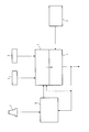
- the arrangement for determining the position of a land vehicle has an arrangement 1 for carrying out dead reckoning.
- a compass 2 and at least one wheel sensor 3 are assigned to this arrangement 1.
- the arrangement 1 is followed by a correction unit 4, which is assigned a mass memory 5, which can be, for example, a compact disc interactive unit.
- a GPS receiver 6 is also provided, which can determine the position of a vehicle on the basis of the received data from several satellites, in which the arrangement shown in FIG. 1 can be installed.
- a satellite reception antenna is provided, which is designated 7 in FIG.
- the GPS receiver 6 continuously delivers position data of the vehicle to the arrangement 1 for performing a dead reckoning. Furthermore, the direction of travel or standing direction of the vehicle is transmitted to this arrangement by means of the compass 2. By means of the edge sensor 3, the arrangement 1 can determine the route and short-term change of direction in the corresponding direction. A dead reckoning can be carried out from these data in a manner known per se, by means of which new position data are continuously determined. This data is supplied to the correction unit 4, which compares this data with street position coordinates read out from the mass memory 5. At striking points in the course of the road, for example in curves or at intersections, the current position can be reliably recognized using the road position coordinates. A corresponding correction value is then formed in the correction unit and the data supplied by the arrangement 1 are corrected as a function of this correction value. The correction unit 4 then supplies the corrected vehicle position coordinates. These coordinates continuously update the vehicle position.
- This output signal which is provided for further processing, is now also supplied to the arrangement 1 and the GPS receiver 6.
- the position data determined by the GPS receiver 6 on the basis of satellite reception have an error (which the system operator of the GPS system intended) of approximately 100 to 200 meters.
- the GPS receiver 6 On the basis of the vehicle position coordinates provided by the correction unit 4, which are quite precise due to the comparison with the street position coordinates read out from the mass memory 5, the GPS receiver 6 is now correcting its position data. The GPS receiver 6 then delivers position data already corrected on the output side.
- the accuracy of the arrangement shown in the figure for determining the position of a country vehicle is therefore quite accurate.
- the accuracy while the vehicle is traveling results from the combination of dead reckoning with the comparison of the street position coordinates from the mass memory and the ongoing correction of the GPS data. Even after transporting a vehicle or restarting a vehicle at an unknown location, the position of the vehicle in which the arrangement is installed can be determined quite accurately by correcting the data of the GPS receiver.
Abstract
Description
Die Erfindung betrifft eine Anordnung zur Positionsbestimmung eines Landfahrzeuges mit einem GPS-(Global-Positioning-System-)Empfänger, welcher mit Hilfe von Satelliten empfangenen Daten regelmäßig wiederholt Positions-Daten des Fahrezugs liefert, mit einer Anordnung zur Durchführung einer Koppelnavigation anhand der Positions-Daten des GPS-Empfängers, eines Kompasses und wenigstens eines Radsensors und mit einer Korrektur- Einheit, welche die von der Anordnung zur Durchführung der Koppelnavigation regelmäßig wiederholt gelieferten Koppelnavigationswerte in Abhängigkeit von Vergleichen mit aus einem Massenspeicher ausgelesenen Straßen- oder Schienenpositions-Koordinaten, insbesondere mit markanten Straßen- oder Schienenpositions-Koordinaten, korrigiert, und als Fahrzeug-Positions-Koordinaten liefert.The invention relates to an arrangement for determining the position of a land vehicle with a GPS (global positioning system) receiver, which regularly delivers position data of the vehicle repeatedly with the aid of data received from satellites, with an arrangement for performing a dead reckoning using the position Data from the GPS receiver, a compass and at least one wheel sensor and with a correction unit which determines the dead reckoning values regularly provided by the arrangement for carrying out dead reckoning depending on comparisons with street or rail position coordinates read from a mass memory, in particular with striking street or rail position coordinates, corrected and as vehicle position coordinates.
Bei bekannten derartigen Anordnungen wird mittels Koppelnavigation (engl.: dead-reckoning), welche insbesondere mittels eines Kompasses mit einem oder mehreren Radsensoren arbeitet, laufend die aktuelle Fahrzeugposition bestimmt. Die dabei auftretenden Fehler können durch Vergleich mit aus einem Massenspeicher ausgelesenen Straßenpositions-Koordinaten korrigiert werden (engl.: map matching). Insbesondere markante Straßenpositions-Koordinaten, beispielsweise Kurven im Straßenverlauf oder Kreuzungen, können leicht erkannt werden und es kann die mittels Koppelnavigation bestimmte Position des Fahrzeugs entsprechend den Koordinaten der bekannten markanten Punkte korrigiert werden.In known arrangements of this type, the current vehicle position is continuously determined by means of dead reckoning, which works in particular by means of a compass with one or more wheel sensors. The errors that occur can be corrected by comparison with road position coordinates read from a mass memory (map matching). In particular, distinctive road position coordinates, for example curves in the course of the road or intersections, can be easily recognized and the position of the vehicle determined by means of dead reckoning can be corrected in accordance with the coordinates of the known distinctive points.
Diese Kombination von Koppelnavigation und Korrektur durch Straßenpositions-Koordinaten versagt bei Start des Fahrzeugs bzw. allgemein bei unbekannten Straßenpositions-Koordinaten, die sich auch nach Transport des Fahrzeugs mittels Bahn oder Schiff oder ähnlichem ergeben können. Dazu ist bei bekannten Anordnungen ein GPS-Empfänger vorgesehen, welcher Signale von GPS-Satelliten empfängt und anhand deren Empfang, insbesondere aus den Phasenverschiebungen von deren Signalen relativ zueinander, die Position des GPS-Empfängers bzw. des Fahrzeugs berechnen kann. Die Genauigkeit dieser Positionsbestimmung mittels eines GPS-Empfängers beträgt jedoch nur einige 100 Meter, was beispielsweise für die genaue Bestimmung eines Standorts des Fahrzeugs in einer Stadt nicht ausreichend ist.This combination of dead reckoning and correction by road position coordinates fails when the vehicle is started or generally when the road position coordinates are unknown, which can also result after the vehicle has been transported by train or ship or the like. In known arrangements, a GPS receiver is provided for this purpose, which receives signals from GPS satellites and can calculate the position of the GPS receiver or of the vehicle on the basis of their reception, in particular from the phase shifts of their signals relative to one another. However, the accuracy of this position determination using a GPS receiver is only a few 100 meters, which is not sufficient, for example, for the exact determination of a location of the vehicle in a city.
Bei bekannten Anordnungen dieser Art wird die Korrektur der von dem GPS-Empfänger gelieferten Positions-Daten mittels eines Datenkanals vorgenommen. Über diesen Datenkanal wird dem GPS-Empfänger von außen über zusätzlich vorzusehende Infrastruktur wiederholt die sich ständig ändernde Größe und Richtung des Fehlers mitgeteilt.In known arrangements of this type, the position data supplied by the GPS receiver is corrected by means of a data channel. The GPS receiver is repeatedly informed of the constantly changing size and direction of the error via this data channel from the outside via additional infrastructure to be provided.
Es ist Aufgabe der Erfindung, eine Anordnung zu schaffen, die die Korrektur der Positions-Daten des GPS-Empfängers auf möglichst einfache Weise vornimmt.It is an object of the invention to provide an arrangement which undertakes the correction of the position data of the GPS receiver in the simplest possible way.
Diese Aufgabe ist erfindungsgemäß dadurch gelöst, daß die von der Korrektureinheit gelieferten Fahrzeug-Positions-Koordinaten dem GPS-Empfänger zugeführt werden und daß in dem GPS-Empfänger die aus den Satellitenempfang gewonnenen Positions-Daten nach Maßgabe der von der Korrektur-Einheit gelieferten Fahrzeug-Positions-Koordinaten berichtigt und in der berichtigten Form als Positions-Daten an die Anordnung zur Durchführung der Koppelnavigation geliefert werden.This object is achieved in that the vehicle position coordinates supplied by the correction unit are fed to the GPS receiver and that in the GPS receiver the position data obtained from the satellite reception in accordance with the vehicle supplied by the correction unit Corrected position coordinates and be supplied in the corrected form as position data to the arrangement for performing the dead reckoning.
Die von der Korrektureinheit gelieferten Fahrzeug-Positions-Koordinaten, die laufend die aktuelle Fahrzeugposition angeben, werden also auch dazu verwendet, im GPS-Empfänger dessen Positions-Daten zu korrigieren. Dies ist deshalb möglich, weil die Fahrzeug-Positions-Koordinaten, die mit den aus dem Massenspeicher ausgelesenen Straßenpositions-Koordinaten verglichen und entsprechend korrigiert worden sind, recht genau sind. Der Fehler in den Positions-Daten des GPS-Empfängers ist in jedem Falle größer und verändert sich zeitlich nur sehr langsam. Es kann daher die Korrektur mittels der Fahrzeug-Positions-Koordinaten in hinreichenden Zeitabständen vorgenommen werden. Der GPS-Empfänger liefert nachfolgend recht genaue Positions-Daten, so daß nachfolgend die in der Korrektur-Einheit erfolgende Korrektur kleiner ausfallen kann. In diesem quasi rückgekoppelten Zustand des Systems sind schließlich die GPS-Daten so genau, daß sie gebenenfalls recht genau die aktuelle Position angeben.The vehicle position coordinates supplied by the correction unit, which continuously indicate the current vehicle position, are also used to correct its position data in the GPS receiver. This is possible because the vehicle position coordinates, which have been compared with the street position coordinates read from the mass memory and have been corrected accordingly, are quite precise. The error in the position data of the GPS receiver is larger in any case and changes only very slowly over time. The correction can therefore be carried out by means of the vehicle position coordinates in sufficient time intervals. The GPS receiver subsequently delivers very precise position data, so that subsequently the correction carried out in the correction unit can be smaller. In this quasi-feedback state of the system, the GPS data is finally so accurate that it may indicate the current position quite accurately.
Bei dieser Lösung zur Korrektur der Daten des GPS-Empfängers kann insbesondere ein externer Datenkanal entfallen, der zusätzliche Infrastruktur durch Dritte erfordert. Ferner ist die räumliche Trennung zwischen einem externen Datengeber und dem GPS-Empfänger im Fahrzeug aufgehoben, wodurch zusätzliche Fehler, die sich durch diese Trennung ergeben, entfallen. Dadurch entfallen auch die Fehler, die bei räumlicher Trennung durch die begrenzte Übertragungsgeschwindigkeit entstehen. Die Korrektur der Daten des GPS-Empfängers kann sehr genau erfolgen. Da die Anordnung zur Durchführung der Koppelnavigation sowie die Korrektur-Einheit in den meisten Anordnungen zur Positionsbestimmung eines Landfahrzeuges ohnehin vorgesehen sind, ist der zusätzliche Aufwand für die Korrektur der Daten des GPS-Empfängers äußerst gering.With this solution for correcting the data of the GPS receiver, in particular an external data channel can be omitted, which requires additional infrastructure by third parties. Furthermore, the spatial separation between an external data transmitter and the GPS receiver in the vehicle is eliminated, which eliminates additional errors that result from this separation. This also eliminates the errors that occur in spatial separation due to the limited transmission speed. The correction of the data of the GPS receiver can be done very precisely. Since the arrangement for performing the dead reckoning navigation and the correction unit are provided in most arrangements for determining the position of a land vehicle, the additional effort for correcting the data of the GPS receiver is extremely low.
Gemäß weiteren Ausgestaltungen der Erfindung ist vorgesehen, daß die Korrektur-Einheit jeweils bei Auftreten eines neuen markanten Punktes in den Straßenpositions-Koordinaten einen neuen internen Korrekturwert bestimmt, in Abhängigkeit dessen die von der Anordnung zur Durchführung der Koppelnavigation nachfolgend gelieferten Daten korrigiert werden und daß der interne Korrekturwert bis zum nächsten markanten Punkt in den Straßenpositions-Koordinaten, für den ein neuer interner Korrekturwert bestimmt wird, gültig ist.According to further refinements of the invention, it is provided that the correction unit determines a new internal correction value each time a new, distinctive point occurs in the street position coordinates, depending on of which the data subsequently provided by the arrangement for performing the dead reckoning are corrected and that the internal correction value is valid up to the next prominent point in the street position coordinates for which a new internal correction value is determined.
Die in der Korrektur-Einheit erfolgende Korrektur der von der Anordnung zur Durchführung der Koppelnavigation regelmäßig wiederholt gelieferten Koppelnavigationswerte kann insbesondere anhand von markanten Punkten im Straßenverlauf und den zugehörigen in dem Massenspeicher abgelegten Straßenpositions-Koordinaten erfolgen. Derartige markante Punkte treten in unregelmäßigen Zeitabständen auf, so daß zwischen diesen Punkten nicht immer eine Korrektur möglich ist. An diesen markanten Punkten kann jedoch eine Korrektur auf sehr genaue Weise erfolgen, so daß diese Korrektur in zeitlich unregelmäßigen Abständen ausreichend ist. Es wird nun also an jedem neuen markanten Punkt in den Straßenpositions-Koordinaten ein neuer interner Korrekturwert in der Korrektureinheit gebildet, der nachfolgend gültig ist, bis an einem nachfolgenden markanten Punkt ein neuer Korrekturwert gebildet wird. Auch die Korrektur der Positions-Daten des GPS-Empfängers wird entsprechend diesem internen Korrekturwert und der von der Korrektur-Einheit nachfolgend gelieferten Fahrzeug-Positions-Koordinaten vorgenommen. Die Genauigkeit dieser Korrektur ist ausreichend, da sich der Fehler in den Positions-Daten des GPS-Empfängers nur sehr langsam verändert und im allgemeinen davon ausgegangen werden kann, daß er zwischen zwei markanten Punkten in den Straßenpositions-Koordinaten etwa gleich bleibt.The correction in the correction unit of the dead reckoning values regularly supplied repeatedly by the arrangement for carrying out the dead reckoning navigation can take place in particular on the basis of striking points in the course of the road and the associated road position coordinates stored in the mass memory. Such striking points occur at irregular time intervals, so that a correction between these points is not always possible. At these striking points, however, a correction can be made in a very precise manner, so that this correction is sufficient at irregular intervals. A new internal correction value is now formed in the correction unit at each new prominent point in the road position coordinates, which is subsequently valid until a new correction value is formed at a subsequent prominent point. The correction of the position data of the GPS receiver is also carried out in accordance with this internal correction value and the vehicle position coordinates subsequently provided by the correction unit. The accuracy of this correction is sufficient since the error in the position data of the GPS receiver changes only very slowly and it can generally be assumed that it remains approximately the same between two prominent points in the road position coordinates.
Als Massenspeicher kann vorteilhafterweise, wie gemäß einer weiteren Ausgestaltung der Erfindung vorgesehen ist, eine Compact-Disc-Interactive vorgesehen sein, welche hohe Speicherdichte mit geringer Zugriffszeit kombiniert und welche voraussichtlich in der Lage ist, einen großen Teil der erforderlichen Straßenpositions-Koordinaten eines Landes von der Größe Deutschlands aufzunehmen.As a mass storage device, a compact disc interactive can advantageously be provided, as is provided according to a further embodiment of the invention, which combines high storage density with low access time and which is likely to be able to determine a large part of the required street position coordinates of a country the size of Germany.
Anhand der einzigen Figur wird ein Ausführungsbeispiel der Erfindung näher erläutert.An exemplary embodiment of the invention is explained in more detail with reference to the single figure.
In der Figur ist eine erfindungsgemäße Anordnung zur Positionsbestimmung eines Landfahrzeuges in Form eines Blockschaltbildes dargestellt.In the figure, an arrangement according to the invention for determining the position of a land vehicle is shown in the form of a block diagram.
Die Anordnung zur Positionsbestimmung eines Landfahrzeuges weist eine Anordnung 1 zur Durchführung einer Koppelnavigation auf. Dieser Anordnung 1 sind ein Kompaß 2 und wenigstens ein Radsensor 3 zugeordnet. Der Anordnung 1 ist eine Korrektur-Einheit 4 nachgeschaltet, welcher ein Massenspeicher 5 zugeordnet ist, bei welchem es sich beispielsweise um eine Compact-Disc-Interactive-Einheit handeln kann.The arrangement for determining the position of a land vehicle has an arrangement 1 for carrying out dead reckoning. A compass 2 and at least one wheel sensor 3 are assigned to this arrangement 1. The arrangement 1 is followed by a correction unit 4, which is assigned a
Es ist ferner ein GPS-Empfänger 6 vorgesehen, welcher anhand der Empfangs-Daten mehrerer Satelliten eine Positionsbestimmung eines Fahrzeuges, in das die in der Fig. 1 dargestellte Anordnung eingebaut sein kann, vornehmen kann. Zum Empfang der entsprechenden Satelliten ist eine Satelliten-Emfpangs-Antenne vorgesehen, die in der Fig. mit 7 bezeichnet ist.A
Der GPS-Empfänger 6 liefert laufend Positions-Daten des Fahrzeuges an die Anordnung 1 zur Durchführung eines Koppelnavigation. Ferner wird dieser Anordnung mittels des Kompasses 2 die Fahrtrichtung bzw. Standrichtung des Fahrzeuges übermittelt. Mittels des Randsensors 3, kann die Anordnung 1 die Fahrstrecke und kurzfristige Fahrtrichtungsänderung in der entsprechenden Richtung ermitteln. Aus diesen Daten kann eine Koppelnavigation in an sich bekannter Weise durchgeführt werden, mittels derer laufend neue Positions-Daten ermittelt werden. Diese Daten werden an die Korrektur-Einheit 4 geliefert, welche diese Daten mit aus dem Massenspeicher 5 ausgelesenen Straßenpositions-Koordinaten vergleicht. An markanten Punkten im Straßenverlauf, beispielsweise in Kurven oder an Kreuzungen, kann anhand der Straßenpositions-Koordinaten sicher der momentante Standort erkannt werden. Es wird dann in der Korrektureinheit ein entsprechender Korrekturwert gebildet und die von der Anordnung 1 gelieferten Daten werden in Abhängigkeit dieses Korrekturwertes korrigiert. Die Korrektur-Einheit 4 liefert dann die berichtigten Fahrzeug-Positions-Koordinaten. Diese Koordinaten geben laufend erneuert die Fahrzeugposition an.The
Dieses Ausgangssignal, das zur weiteren Verarbeitung bereitgestellt wird, wird nun auch der Anordnung 1 sowie dem GPS-Empfänger 6 zugeführt.This output signal, which is provided for further processing, is now also supplied to the arrangement 1 and the
Die von dem GPS-Empfänger 6 anhand des Satellitenempfangs ermittelten Positions-Daten weisen einen (von dem Systembetreiber des GPS-Systems durchaus beabsichtigten) Fehler von etwa 100 bis 200 Metern auf. Anhand der von der Korrektur-Einheit 4 gelieferten Fahrzeug-Positions-Koordinaten, die durch den Vergleich mit dem aus dem Massenspeicher 5 ausgelesenen Straßenpositions-Koordinaten recht genau sind, wird nun in dem GPS-Empfänger 6 eine Korrektur von dessen Positons-Daten vorgenommen. Der GPS-Empfänger 6 liefert dann ausgangsseitig bereits korrigierte Positions-Daten.The position data determined by the
In der Anordnung 1 kann dann aufgrund der von dem GPS-Empfänger gelieferten korrigierten Positions-Daten bzw. der von der Korrektur-Einheit 4 gelieferten Fahrzeug-Positions-Koordinaten recht genaue Koppelnavigation durchgeführt werden.In arrangement 1, quite precise coupling navigation can then be carried out on the basis of the corrected position data supplied by the GPS receiver or the vehicle position coordinates supplied by the correction unit 4.
Die Genauigkeit der in der Fig. dargestellten Anordnung zur Positionsbestimmung eines Landfahrzeuges ist somit recht genau. Die Genauigkeit während der Fahrt des Fahrzeugs ergibt sich durch die Kombination von Koppelnavigation mit dem Vergleich der Straßenpositions-Koordinaten aus dem Massenspeicher und der laufenden Korrektur der GPS-Daten. Auch nach Transport eines Fahrzeugs bzw. Neustart eines Fahrzeugs an einem unbekannten Ort, kann durch die Korrektur der Daten des GPS-Empfängers eine recht genaue Positionsbestimmung des Fahrzeugs, in das die Anordnung eingebaut ist, vorgenommen werden.The accuracy of the arrangement shown in the figure for determining the position of a country vehicle is therefore quite accurate. The accuracy while the vehicle is traveling results from the combination of dead reckoning with the comparison of the street position coordinates from the mass memory and the ongoing correction of the GPS data. Even after transporting a vehicle or restarting a vehicle at an unknown location, the position of the vehicle in which the arrangement is installed can be determined quite accurately by correcting the data of the GPS receiver.
Claims (5)
Applications Claiming Priority (2)
| Application Number | Priority Date | Filing Date | Title |
|---|---|---|---|
| DE4211933A DE4211933A1 (en) | 1992-04-09 | 1992-04-09 | Arrangement for determining the position of a land vehicle |
| DE4211933 | 1992-04-09 |
Publications (3)
| Publication Number | Publication Date |
|---|---|
| EP0565191A2 true EP0565191A2 (en) | 1993-10-13 |
| EP0565191A3 EP0565191A3 (en) | 1994-09-28 |
| EP0565191B1 EP0565191B1 (en) | 1998-01-21 |
Family
ID=6456465
Family Applications (1)
| Application Number | Title | Priority Date | Filing Date |
|---|---|---|---|
| EP93200992A Expired - Lifetime EP0565191B1 (en) | 1992-04-09 | 1993-04-06 | Device for measuring the position of a ground vehicle |
Country Status (5)
| Country | Link |
|---|---|
| US (1) | US5334986A (en) |
| EP (1) | EP0565191B1 (en) |
| JP (1) | JPH0694472A (en) |
| KR (1) | KR100253605B1 (en) |
| DE (2) | DE4211933A1 (en) |
Cited By (5)
| Publication number | Priority date | Publication date | Assignee | Title |
|---|---|---|---|---|
| GB2280077A (en) * | 1993-07-16 | 1995-01-18 | Caterpillar Inc | Detecting cycle slip in gps receiver |
| ES2102319A1 (en) * | 1993-11-08 | 1997-07-16 | Telia Ab | Arrangement for providing communication and positioning in a guidance installation |
| EP0805358A2 (en) * | 1996-05-02 | 1997-11-05 | Pioneer Electronic Corporation | Method of and apparatus for calculating position of movable body in navigation system, and method of and apparatus for correcting the position |
| WO2000013157A1 (en) * | 1998-08-28 | 2000-03-09 | Robert Bosch Gmbh | Device for controlling and monitoring a vehicle |
| WO2009030521A1 (en) | 2007-08-29 | 2009-03-12 | Continental Teves Ag & Co. Ohg | Correction of a vehicle position by means of characteristic points |
Families Citing this family (117)
| Publication number | Priority date | Publication date | Assignee | Title |
|---|---|---|---|---|
| US8352400B2 (en) | 1991-12-23 | 2013-01-08 | Hoffberg Steven M | Adaptive pattern recognition based controller apparatus and method and human-factored interface therefore |
| US10361802B1 (en) | 1999-02-01 | 2019-07-23 | Blanding Hovenweep, Llc | Adaptive pattern recognition based control system and method |
| US5606506A (en) * | 1993-04-05 | 1997-02-25 | Caterpillar Inc. | Method and apparatus for improving the accuracy of position estimates in a satellite based navigation system using velocity data from an inertial reference unit |
| DE4321509C2 (en) * | 1993-06-29 | 1995-04-20 | Martin Ziegler | Anti-theft alarm system for motor vehicles |
| US5488559A (en) * | 1993-08-02 | 1996-01-30 | Motorola, Inc. | Map-matching with competing sensory positions |
| US5983161A (en) | 1993-08-11 | 1999-11-09 | Lemelson; Jerome H. | GPS vehicle collision avoidance warning and control system and method |
| DE4339600A1 (en) * | 1993-11-20 | 1995-05-24 | Kloeckner Humboldt Deutz Ag | Agricultural or earthmoving vehicle with optical monitoring of working tool |
| JPH07230315A (en) * | 1994-02-16 | 1995-08-29 | Fuji Heavy Ind Ltd | Traveling controller for autonomously traveling vehicle |
| DE19509711C2 (en) * | 1994-03-09 | 1997-10-16 | Mannesmann Ag | Accident data recorder and method for analyzing an accident |
| DE4424412A1 (en) * | 1994-07-12 | 1996-01-18 | Esg Elektroniksystem Und Logis | Radio telecommunication system with satellite navigation for both mobile telephony and VHF radio reception |
| JP3467136B2 (en) * | 1995-11-07 | 2003-11-17 | 富士重工業株式会社 | Travel control device for autonomous vehicles |
| US5862511A (en) * | 1995-12-28 | 1999-01-19 | Magellan Dis, Inc. | Vehicle navigation system and method |
| US5764014A (en) * | 1996-02-01 | 1998-06-09 | Mannesmann Dematic Rapistan Corp. | Automated guided vehicle having ground track sensor |
| WO1998010307A1 (en) | 1996-09-09 | 1998-03-12 | Dennis Jay Dupray | Location of a mobile station |
| US6236365B1 (en) | 1996-09-09 | 2001-05-22 | Tracbeam, Llc | Location of a mobile station using a plurality of commercial wireless infrastructures |
| US9134398B2 (en) | 1996-09-09 | 2015-09-15 | Tracbeam Llc | Wireless location using network centric location estimators |
| JP3260645B2 (en) * | 1997-01-31 | 2002-02-25 | エニー株式会社 | Navigation system |
| US6324592B1 (en) | 1997-02-25 | 2001-11-27 | Keystone Aerospace | Apparatus and method for a mobile computer architecture and input/output management system |
| US6043777A (en) * | 1997-06-10 | 2000-03-28 | Raytheon Aircraft Company | Method and apparatus for global positioning system based cooperative location system |
| US6680694B1 (en) | 1997-08-19 | 2004-01-20 | Siemens Vdo Automotive Corporation | Vehicle information system |
| US6707421B1 (en) * | 1997-08-19 | 2004-03-16 | Siemens Vdo Automotive Corporation | Driver information system |
| EP1005627B1 (en) * | 1997-08-19 | 2003-10-29 | Siemens VDO Automotive Corporation | Vehicle information system |
| DE19754169B4 (en) * | 1997-12-06 | 2008-11-13 | Volkswagen Ag | Device for starting a vehicle-mounted navigation device and control method therefor |
| US7268700B1 (en) | 1998-01-27 | 2007-09-11 | Hoffberg Steven M | Mobile communication device |
| DE19803662C2 (en) * | 1998-01-30 | 1999-12-02 | Siemens Ag | Navigation device and method for determining position using dead reckoning |
| DE19856184A1 (en) * | 1998-12-05 | 2000-06-08 | Alcatel Sa | Method for determining in-vehicle whether the vehicle is on one of several predetermined roads |
| DE19856187A1 (en) * | 1998-12-05 | 2000-06-15 | Alcatel Sa | Satellite-based map matching process |
| US7904187B2 (en) | 1999-02-01 | 2011-03-08 | Hoffberg Steven M | Internet appliance system and method |
| US6166698A (en) * | 1999-02-16 | 2000-12-26 | Gentex Corporation | Rearview mirror with integrated microwave receiver |
| DE19907235A1 (en) * | 1999-02-19 | 2000-09-14 | Daimler Chrysler Ag | GPS navigation system for space applications |
| US6466887B1 (en) | 1999-03-03 | 2002-10-15 | Richard L. Weinbrenner | Gravimetric rotation sensors: dead reckoning, velocity, and heading sensor system for vehicle navigation systems |
| US6192312B1 (en) | 1999-03-25 | 2001-02-20 | Navigation Technologies Corp. | Position determining program and method |
| DE19924155B4 (en) * | 1999-05-26 | 2006-02-09 | Siemens Ag | Method for determining position and navigation device |
| DE60031868T2 (en) * | 1999-09-15 | 2007-09-13 | Sirf Technology, Inc., San Jose | NAVIGATION SYSTEM AND METHOD FOR FOLLOWING THE POSITION OF AN OBJECT |
| DE19945124A1 (en) * | 1999-09-21 | 2001-04-26 | Mannesmann Vdo Ag | Vehicle in-car navigation method involves setting actual position back to control position if spacing between positions exceed error value such that error value is changed depending on reliability test |
| US6516273B1 (en) | 1999-11-04 | 2003-02-04 | Veridian Engineering, Inc. | Method and apparatus for determination and warning of potential violation of intersection traffic control devices |
| DE10021373A1 (en) * | 2000-05-02 | 2001-11-08 | Siemens Ag | Positioning method and navigation device |
| US6803861B2 (en) | 2000-05-17 | 2004-10-12 | Omega Patents, L.L.C. | Vehicle tracking unit with fault condition diagnosis and related methods |
| US6798355B2 (en) | 2000-05-17 | 2004-09-28 | Omega Patents, L.L.C. | Vehicle tracker including security device monitoring bypass feature and related methods |
| US6765500B2 (en) | 2000-05-17 | 2004-07-20 | Omega Patents, L.L.C. | Vehicle tracker including missed call feature and related methods |
| US6765499B2 (en) | 2000-05-17 | 2004-07-20 | Omega Patents, L.L.C. | Vehicle tracker unit providing variable frequency transmission and related methods |
| US6809659B2 (en) | 2000-05-17 | 2004-10-26 | Omega Patents, L.L.C. | Vehicle tracker with test features and related methods |
| US6703946B2 (en) | 2000-05-17 | 2004-03-09 | Omega Patents, L.L.C. | Vehicle tracking unit having a self diagnostic mode and related methods |
| US6798356B2 (en) | 2000-05-17 | 2004-09-28 | Omega Patents, L.L.C. | Vehicle tracking unit providing direction deviation tracking and related methods |
| US6771188B2 (en) | 2000-05-17 | 2004-08-03 | Omega Patents, L.L.C. | Vehicle control system for controlling a vehicle function including a vehicle tracking unit and related methods |
| US6741187B2 (en) | 2000-05-17 | 2004-05-25 | Omega Patents, L.L.C. | Vehicle tracker providing vehicle alarm alert features and related methods |
| US6507786B2 (en) | 2000-05-17 | 2003-01-14 | Omega Patents, L.L.C. | Vehicle tracker with user registration reminder and related methods |
| US6512466B2 (en) | 2000-05-17 | 2003-01-28 | Omega Patents, L.L.C. | Vehicle tracker with power saving features and related methods |
| US6784809B2 (en) | 2000-05-17 | 2004-08-31 | Omega Patents, L.L.C. | Vehicle tracker including override feature and related methods |
| US6512465B2 (en) | 2000-05-17 | 2003-01-28 | Omega Patents, L.L.C. | Vehicle tracker including stationary time determination and associated methods |
| US6844827B2 (en) * | 2000-05-17 | 2005-01-18 | Omega Patents, L.L.C. | Vehicle tracker including a connector for an upgrade device and related methods |
| US6804605B2 (en) | 2000-05-17 | 2004-10-12 | Omega Patents, L.L.C. | Vehicle tracker with user registration reminder and related methods |
| US6693563B2 (en) | 2000-05-17 | 2004-02-17 | Omega Patents, L.L.C. | Vehicle tracking unit providing theft alert notifications and related methods |
| US6744384B2 (en) | 2000-05-17 | 2004-06-01 | Omega Patents, L.L.C. | Vehicle tracker having switchable polarity output terminals and related methods |
| US6509868B2 (en) | 2000-05-17 | 2003-01-21 | Omega Patents, L.L.C. | Vehicle tracker with user notifications and associated methods |
| US6522267B2 (en) | 2000-05-17 | 2003-02-18 | Omega Patents, L.L.C. | Vehicle tracker conserving codes and related methods |
| US6816089B2 (en) | 2000-05-17 | 2004-11-09 | Omega Patents, L.L.C. | Vehicle tracker having find alert features and related methods |
| US6737989B2 (en) | 2000-05-17 | 2004-05-18 | Omega Patents, L.L.C. | Vehicle tracker including variable frequency transmission and related methods |
| US6819269B2 (en) | 2000-05-17 | 2004-11-16 | Omega Patents, L.L.C. | Vehicle tracker including battery monitoring feature and related methods |
| US7671727B2 (en) | 2000-05-17 | 2010-03-02 | Omega Patents, L.L.C. | Speed exceeded notification device for vehicle having a data bus and associated methods |
| US6924750B2 (en) * | 2000-05-17 | 2005-08-02 | Omega Patents, L.L.C. | Vehicle tracking unit for controlling operable vehicle devices using a vehicle data bus and related methods |
| USRE47354E1 (en) | 2000-05-17 | 2019-04-16 | Omega Patents, L.L.C. | Vehicle tracking unit for controlling operable vehicle devices using a vehicle data bus and related methods |
| US6606561B2 (en) * | 2000-05-17 | 2003-08-12 | Omega Patents, L.L.C. | Vehicle tracker including input/output features and related methods |
| USRE47225E1 (en) | 2000-05-17 | 2019-02-05 | Omega Patents, L.L.C. | Vehicle tracking unit for controlling operable vehicle devices using a vehicle data bus and related methods |
| US7031835B2 (en) | 2000-05-17 | 2006-04-18 | Omega Patents, L.L.C. | Vehicle tracker cooperating with a starter interrupt and related methods |
| US10641861B2 (en) | 2000-06-02 | 2020-05-05 | Dennis J. Dupray | Services and applications for a communications network |
| US9875492B2 (en) | 2001-05-22 | 2018-01-23 | Dennis J. Dupray | Real estate transaction system |
| US10684350B2 (en) | 2000-06-02 | 2020-06-16 | Tracbeam Llc | Services and applications for a communications network |
| US6311109B1 (en) | 2000-07-24 | 2001-10-30 | New York Air Brake Corporation | Method of determining train and track characteristics using navigational data |
| US6502033B1 (en) | 2000-10-05 | 2002-12-31 | Navigation Technologies Corp. | Turn detection algorithm for vehicle positioning |
| US6317683B1 (en) | 2000-10-05 | 2001-11-13 | Navigation Technologies Corp. | Vehicle positioning using three metrics |
| GB2368480A (en) * | 2000-10-23 | 2002-05-01 | Apricot Interactive Ltd | Vehicle tracking |
| DE10063585A1 (en) * | 2000-12-20 | 2002-07-11 | Volkswagen Ag | Method for recognizing carriageway-related local information during the use of navigation systems in motor vehicles evaluates patterns for a motor vehicle's vibration arising from driving through local conditions |
| US6597987B1 (en) * | 2001-05-15 | 2003-07-22 | Navigation Technologies Corp. | Method for improving vehicle positioning in a navigation system |
| US6631321B1 (en) | 2001-10-29 | 2003-10-07 | Navigation Technologies Corp. | Vehicle heading change determination using compensated differential wheel speed |
| US7534223B2 (en) | 2002-10-08 | 2009-05-19 | Boston Scientific Scimed, Inc. | Catheter with formed guide wire ramp |
| US9818136B1 (en) | 2003-02-05 | 2017-11-14 | Steven M. Hoffberg | System and method for determining contingent relevance |
| EP1500907B1 (en) * | 2003-07-21 | 2014-11-12 | LG Electronics, Inc. | Apparatus and method for detecting vehicle location in navigation system |
| KR20050075046A (en) * | 2004-01-15 | 2005-07-20 | 정은철 | Remote control system of mobile body |
| DE102004023006A1 (en) * | 2004-05-10 | 2005-12-01 | Robert Bosch Gmbh | Method and device for determining the position of a toll collection system |
| US7647177B2 (en) * | 2005-03-31 | 2010-01-12 | Deere & Company | System and method for determining a position of a vehicle |
| US7720598B2 (en) * | 2005-03-31 | 2010-05-18 | Deere & Company | System and method for determining a position of a vehicle with compensation for noise or measurement error |
| US7653483B2 (en) * | 2005-03-31 | 2010-01-26 | Deere & Company | System and method for determining a position of a vehicle |
| US9121715B2 (en) * | 2005-04-14 | 2015-09-01 | General Motors Llc | Method for determining vehicle location including road surface data |
| US7330122B2 (en) | 2005-08-10 | 2008-02-12 | Remotemdx, Inc. | Remote tracking and communication device |
| JP2007232635A (en) * | 2006-03-02 | 2007-09-13 | Seiko Epson Corp | Positioning device, control method of positioning device, control program of positioning device and computer readable medium recording control program of positioning device |
| US8797210B2 (en) | 2006-07-14 | 2014-08-05 | Securealert, Inc. | Remote tracking device and a system and method for two-way voice communication between the device and a monitoring center |
| US7936262B2 (en) | 2006-07-14 | 2011-05-03 | Securealert, Inc. | Remote tracking system with a dedicated monitoring center |
| US7737841B2 (en) | 2006-07-14 | 2010-06-15 | Remotemdx | Alarm and alarm management system for remote tracking devices |
| US7659810B2 (en) | 2007-08-24 | 2010-02-09 | Omega Patents, L.L.C. | Speed exceeded notification device for vehicle having a data bus and associated methods |
| US7659811B2 (en) * | 2007-08-24 | 2010-02-09 | Omega Patents, L.L.C. | Vehicle device to activate a visual or audible alert and associated methods |
| US20090177382A1 (en) * | 2008-01-03 | 2009-07-09 | Commscope, Inc. Of North Carolina | Calibration of a Navigation System |
| US8232876B2 (en) | 2008-03-07 | 2012-07-31 | Securealert, Inc. | System and method for monitoring individuals using a beacon and intelligent remote tracking device |
| US20090319186A1 (en) * | 2008-06-24 | 2009-12-24 | Honeywell International Inc. | Method and apparatus for determining a navigational state of a vehicle |
| DE102008052642A1 (en) * | 2008-08-26 | 2010-03-04 | Init Innovative Informatikanwendungen In Transport-, Verkehrs- Und Leitsystemen Gmbh | Method and device for locating a vehicle |
| US8195342B2 (en) * | 2008-09-11 | 2012-06-05 | Deere & Company | Distributed knowledge base for vehicular localization and work-site management |
| US20100063652A1 (en) * | 2008-09-11 | 2010-03-11 | Noel Wayne Anderson | Garment for Use Near Autonomous Machines |
| US8224500B2 (en) * | 2008-09-11 | 2012-07-17 | Deere & Company | Distributed knowledge base program for vehicular localization and work-site management |
| US8818567B2 (en) * | 2008-09-11 | 2014-08-26 | Deere & Company | High integrity perception for machine localization and safeguarding |
| US8229618B2 (en) * | 2008-09-11 | 2012-07-24 | Deere & Company | Leader-follower fully autonomous vehicle with operator on side |
| US9188980B2 (en) * | 2008-09-11 | 2015-11-17 | Deere & Company | Vehicle with high integrity perception system |
| US8989972B2 (en) | 2008-09-11 | 2015-03-24 | Deere & Company | Leader-follower fully-autonomous vehicle with operator on side |
| US9026315B2 (en) | 2010-10-13 | 2015-05-05 | Deere & Company | Apparatus for machine coordination which maintains line-of-site contact |
| US8392065B2 (en) * | 2008-09-11 | 2013-03-05 | Deere & Company | Leader-follower semi-autonomous vehicle with operator on side |
| US8195358B2 (en) | 2008-09-11 | 2012-06-05 | Deere & Company | Multi-vehicle high integrity perception |
| US8478493B2 (en) * | 2008-09-11 | 2013-07-02 | Deere & Company | High integrity perception program |
| US9235214B2 (en) * | 2008-09-11 | 2016-01-12 | Deere & Company | Distributed knowledge base method for vehicular localization and work-site management |
| US8095410B2 (en) * | 2008-12-18 | 2012-01-10 | Motorola Solutions, Inc. | Pass through for improved response time |
| US9234760B2 (en) * | 2010-01-29 | 2016-01-12 | Blackberry Limited | Portable mobile transceiver for GPS navigation and vehicle data input for dead reckoning mode |
| US8514070B2 (en) | 2010-04-07 | 2013-08-20 | Securealert, Inc. | Tracking device incorporating enhanced security mounting strap |
| US9538493B2 (en) | 2010-08-23 | 2017-01-03 | Finetrak, Llc | Locating a mobile station and applications therefor |
| JP5783093B2 (en) * | 2012-03-13 | 2015-09-24 | アイシン・エィ・ダブリュ株式会社 | Moving body position detection system, moving body position detection apparatus, moving body position detection method, and computer program |
| WO2015016406A1 (en) * | 2013-08-01 | 2015-02-05 | 자동차부품연구원 | System and method for correcting absolute positioning of vehicle |
| US10136576B2 (en) * | 2013-11-12 | 2018-11-27 | Husqvarna Ab | Navigation for a robotic working tool |
| FR3030373B1 (en) | 2014-12-17 | 2018-03-23 | Continental Automotive France | METHOD FOR ESTIMATING THE RELIABILITY OF WHEEL SENSOR MEASUREMENTS OF A VEHICLE AND SYSTEM FOR IMPLEMENTING SAID METHOD |
| KR20170005912A (en) | 2015-07-06 | 2017-01-17 | 현대로템 주식회사 | Device for operating train using dgps and railroad train having the same |
| US11898850B2 (en) * | 2019-05-08 | 2024-02-13 | Hitachi Astemo, Ltd. | Vehicle position detection device and parameter set creation device for vehicle position detection |
Citations (4)
| Publication number | Priority date | Publication date | Assignee | Title |
|---|---|---|---|---|
| US4357593A (en) * | 1979-09-06 | 1982-11-02 | Siemens Aktiengesellschaft | Guidance system for individual traffic |
| US4903212A (en) * | 1987-03-13 | 1990-02-20 | Mitsubishi Denki Kabushiki Kaisha | GPS/self-contained combination type navigation system |
| DE4033326A1 (en) * | 1989-10-20 | 1991-04-25 | Mazda Motor | VEHICLE NAVIGATION DEVICE |
| DE4130367A1 (en) * | 1990-09-12 | 1992-03-19 | Mitsubishi Electric Corp | VEHICLE OWN POSITION DETECTOR |
Family Cites Families (6)
| Publication number | Priority date | Publication date | Assignee | Title |
|---|---|---|---|---|
| JPS57159310A (en) * | 1981-03-28 | 1982-10-01 | Nissan Motor Co Ltd | Running inductive device for car |
| US4912645A (en) * | 1987-03-26 | 1990-03-27 | Mazda Motor Corporation | Automotive navigation system |
| CA1321418C (en) * | 1988-10-05 | 1993-08-17 | Joseph C. Mcmillan | Primary land arctic navigation system |
| US5087919A (en) * | 1989-09-05 | 1992-02-11 | Pioneer Electronic Corporation | On-board navigation apparatus |
| JPH0827593B2 (en) * | 1989-10-24 | 1996-03-21 | マツダ株式会社 | Navigation device for mobile |
| JPH049710A (en) * | 1990-04-27 | 1992-01-14 | Pioneer Electron Corp | Navigation apparatus for vehicle |
-
1992
- 1992-04-09 DE DE4211933A patent/DE4211933A1/en not_active Withdrawn
-
1993
- 1993-03-29 US US08/038,432 patent/US5334986A/en not_active Expired - Fee Related
- 1993-04-06 DE DE59308006T patent/DE59308006D1/en not_active Expired - Fee Related
- 1993-04-06 KR KR1019930005670A patent/KR100253605B1/en not_active IP Right Cessation
- 1993-04-06 EP EP93200992A patent/EP0565191B1/en not_active Expired - Lifetime
- 1993-04-08 JP JP5081873A patent/JPH0694472A/en active Pending
Patent Citations (4)
| Publication number | Priority date | Publication date | Assignee | Title |
|---|---|---|---|---|
| US4357593A (en) * | 1979-09-06 | 1982-11-02 | Siemens Aktiengesellschaft | Guidance system for individual traffic |
| US4903212A (en) * | 1987-03-13 | 1990-02-20 | Mitsubishi Denki Kabushiki Kaisha | GPS/self-contained combination type navigation system |
| DE4033326A1 (en) * | 1989-10-20 | 1991-04-25 | Mazda Motor | VEHICLE NAVIGATION DEVICE |
| DE4130367A1 (en) * | 1990-09-12 | 1992-03-19 | Mitsubishi Electric Corp | VEHICLE OWN POSITION DETECTOR |
Cited By (12)
| Publication number | Priority date | Publication date | Assignee | Title |
|---|---|---|---|---|
| GB2280077A (en) * | 1993-07-16 | 1995-01-18 | Caterpillar Inc | Detecting cycle slip in gps receiver |
| GB2280077B (en) * | 1993-07-16 | 1997-07-09 | Caterpillar Inc | Method and apparatus for detecting cycle slips in a satellite based navigation system |
| US6175806B1 (en) | 1993-07-16 | 2001-01-16 | Caterpillar Inc. | Method and apparatus for detecting cycle slips in navigation signals received at a receiver from a satellite-based navigation system |
| ES2102319A1 (en) * | 1993-11-08 | 1997-07-16 | Telia Ab | Arrangement for providing communication and positioning in a guidance installation |
| EP0805358A2 (en) * | 1996-05-02 | 1997-11-05 | Pioneer Electronic Corporation | Method of and apparatus for calculating position of movable body in navigation system, and method of and apparatus for correcting the position |
| EP0805358A3 (en) * | 1996-05-02 | 1998-06-17 | Pioneer Electronic Corporation | Method of and apparatus for calculating position of movable body in navigation system, and method of and apparatus for correcting the position |
| US5949375A (en) * | 1996-05-02 | 1999-09-07 | Pioneer Electronic Corporation | Method of and apparatus for calculating position of movable body in navigation system, method of and apparatus for correcting the position, and program storage device readable by the apparatus |
| WO2000013157A1 (en) * | 1998-08-28 | 2000-03-09 | Robert Bosch Gmbh | Device for controlling and monitoring a vehicle |
| US6459967B1 (en) | 1998-08-28 | 2002-10-01 | Robert Bosch Gmbh | Device for controlling and monitoring a vehicle |
| WO2009030521A1 (en) | 2007-08-29 | 2009-03-12 | Continental Teves Ag & Co. Ohg | Correction of a vehicle position by means of characteristic points |
| CN101796375B (en) * | 2007-08-29 | 2013-03-13 | 大陆-特韦斯贸易合伙股份公司及两合公司 | Correction of a vehicle position by means of characteristic points |
| US8442791B2 (en) | 2007-08-29 | 2013-05-14 | Continental Teves Ag & Co. Ohg | Correction of a vehicle position by means of landmarks |
Also Published As
| Publication number | Publication date |
|---|---|
| JPH0694472A (en) | 1994-04-05 |
| DE59308006D1 (en) | 1998-02-26 |
| EP0565191A3 (en) | 1994-09-28 |
| KR930022095A (en) | 1993-11-23 |
| US5334986A (en) | 1994-08-02 |
| KR100253605B1 (en) | 2000-04-15 |
| EP0565191B1 (en) | 1998-01-21 |
| DE4211933A1 (en) | 1993-10-14 |
Similar Documents
| Publication | Publication Date | Title |
|---|---|---|
| EP0565191B1 (en) | Device for measuring the position of a ground vehicle | |
| EP0721570B1 (en) | Position-finding and navigation equipment with satellite back-up | |
| EP3724688A1 (en) | Method and device for detecting correction information for an antenna of a vehicle | |
| EP0759151B1 (en) | Correction process and navigation system for the compound location of a motor vehicle | |
| DE69636482T2 (en) | IMPROVED VEHICLE NAVIGATION SYSTEM AND METHOD THROUGH GPS SPEEDS | |
| DE102011017115B4 (en) | Method and device for a geographic support solution for navigation satellite systems | |
| EP0814345A2 (en) | Mobile object positioning system, especially for vehicles | |
| EP0935760B1 (en) | Position location system for vehicle fitted with a satellite signal receiver | |
| DE102016120235A1 (en) | Method and system for determining a position of a mobile device | |
| DE19746427A1 (en) | GPS satellite location method for trains | |
| DE10030455A1 (en) | Arrangement for generating road information from stored digital map database has application unit implementing arc approximation logic that clears data outside defined window | |
| DE102018205205A1 (en) | Method for determining the position of a vehicle | |
| DE19625561A1 (en) | Automatic navigation course control method for ships | |
| DE3227547A1 (en) | Navigation system | |
| DE102018220782A1 (en) | Localization of a vehicle based on dynamic objects | |
| EP1167923B1 (en) | Digital road map and method of navigation using a digital road map | |
| EP2223148A1 (en) | Method and device for determining the location of a vehicle | |
| EP1217384B1 (en) | Method of determining the position of geostationary satellites using time-of-flight measurements of satellite navigation signals | |
| EP0840137A2 (en) | Method of satellite navigation | |
| DE19945123C2 (en) | Method of navigating a vehicle | |
| DE10148224A1 (en) | Method and system for determining card data | |
| DE69832926T2 (en) | Method and system for real-time position determination by means of radio satellites, in particular GPS satellites | |
| DE102016004370A1 (en) | Method for determining the position of vehicles | |
| DE102020107542A1 (en) | Determining a position of a vehicle | |
| DE4312670A1 (en) | Device for determining the position of a moving object |
Legal Events
| Date | Code | Title | Description |
|---|---|---|---|
| PUAI | Public reference made under article 153(3) epc to a published international application that has entered the european phase |
Free format text: ORIGINAL CODE: 0009012 |
|
| AK | Designated contracting states |
Kind code of ref document: A2 Designated state(s): DE FR GB IT SE |
|
| PUAL | Search report despatched |
Free format text: ORIGINAL CODE: 0009013 |
|
| RAP1 | Party data changed (applicant data changed or rights of an application transferred) |
Owner name: N.V. PHILIPS' GLOEILAMPENFABRIEKEN Owner name: PHILIPS PATENTVERWALTUNG GMBH |
|
| AK | Designated contracting states |
Kind code of ref document: A3 Designated state(s): DE FR GB IT SE |
|
| 17P | Request for examination filed |
Effective date: 19950328 |
|
| GRAG | Despatch of communication of intention to grant |
Free format text: ORIGINAL CODE: EPIDOS AGRA |
|
| 17Q | First examination report despatched |
Effective date: 19970409 |
|
| GRAG | Despatch of communication of intention to grant |
Free format text: ORIGINAL CODE: EPIDOS AGRA |
|
| GRAH | Despatch of communication of intention to grant a patent |
Free format text: ORIGINAL CODE: EPIDOS IGRA |
|
| GRAH | Despatch of communication of intention to grant a patent |
Free format text: ORIGINAL CODE: EPIDOS IGRA |
|
| GRAA | (expected) grant |
Free format text: ORIGINAL CODE: 0009210 |
|
| AK | Designated contracting states |
Kind code of ref document: B1 Designated state(s): DE FR GB IT SE |
|
| REF | Corresponds to: |
Ref document number: 59308006 Country of ref document: DE Date of ref document: 19980226 |
|
| ITF | It: translation for a ep patent filed |
Owner name: ING. C. GREGORJ S.P.A. |
|
| GBT | Gb: translation of ep patent filed (gb section 77(6)(a)/1977) |
Effective date: 19980325 |
|
| ET | Fr: translation filed | ||
| RAP4 | Party data changed (patent owner data changed or rights of a patent transferred) |
Owner name: KONINKLIJKE PHILIPS ELECTRONICS N.V. Owner name: PHILIPS PATENTVERWALTUNG GMBH |
|
| REG | Reference to a national code |
Ref country code: GB Ref legal event code: 732E |
|
| REG | Reference to a national code |
Ref country code: FR Ref legal event code: TP |
|
| PLBE | No opposition filed within time limit |
Free format text: ORIGINAL CODE: 0009261 |
|
| STAA | Information on the status of an ep patent application or granted ep patent |
Free format text: STATUS: NO OPPOSITION FILED WITHIN TIME LIMIT |
|
| 26N | No opposition filed | ||
| PGFP | Annual fee paid to national office [announced via postgrant information from national office to epo] |
Ref country code: GB Payment date: 20000313 Year of fee payment: 8 |
|
| PGFP | Annual fee paid to national office [announced via postgrant information from national office to epo] |
Ref country code: SE Payment date: 20000320 Year of fee payment: 8 |
|
| PGFP | Annual fee paid to national office [announced via postgrant information from national office to epo] |
Ref country code: FR Payment date: 20000327 Year of fee payment: 8 |
|
| PG25 | Lapsed in a contracting state [announced via postgrant information from national office to epo] |
Ref country code: GB Free format text: LAPSE BECAUSE OF NON-PAYMENT OF DUE FEES Effective date: 20010406 |
|
| PG25 | Lapsed in a contracting state [announced via postgrant information from national office to epo] |
Ref country code: SE Free format text: LAPSE BECAUSE OF NON-PAYMENT OF DUE FEES Effective date: 20010407 |
|
| PG25 | Lapsed in a contracting state [announced via postgrant information from national office to epo] |
Ref country code: FR Free format text: THE PATENT HAS BEEN ANNULLED BY A DECISION OF A NATIONAL AUTHORITY Effective date: 20010430 |
|
| GBPC | Gb: european patent ceased through non-payment of renewal fee |
Effective date: 20010406 |
|
| EUG | Se: european patent has lapsed |
Ref document number: 93200992.1 |
|
| REG | Reference to a national code |
Ref country code: FR Ref legal event code: ST |
|
| PGFP | Annual fee paid to national office [announced via postgrant information from national office to epo] |
Ref country code: DE Payment date: 20020618 Year of fee payment: 10 |
|
| PG25 | Lapsed in a contracting state [announced via postgrant information from national office to epo] |
Ref country code: DE Free format text: LAPSE BECAUSE OF NON-PAYMENT OF DUE FEES Effective date: 20031101 |
|
| PG25 | Lapsed in a contracting state [announced via postgrant information from national office to epo] |
Ref country code: IT Free format text: LAPSE BECAUSE OF NON-PAYMENT OF DUE FEES Effective date: 20050406 |