EP0349652B1 - Vehicle navigation system - Google Patents
Vehicle navigation system Download PDFInfo
- Publication number
- EP0349652B1 EP0349652B1 EP89900885A EP89900885A EP0349652B1 EP 0349652 B1 EP0349652 B1 EP 0349652B1 EP 89900885 A EP89900885 A EP 89900885A EP 89900885 A EP89900885 A EP 89900885A EP 0349652 B1 EP0349652 B1 EP 0349652B1
- Authority
- EP
- European Patent Office
- Prior art keywords
- course
- vehicle
- data
- intersection
- distance
- Prior art date
- Legal status (The legal status is an assumption and is not a legal conclusion. Google has not performed a legal analysis and makes no representation as to the accuracy of the status listed.)
- Expired - Lifetime
Links
Images


Classifications
-
- G—PHYSICS
- G01—MEASURING; TESTING
- G01C—MEASURING DISTANCES, LEVELS OR BEARINGS; SURVEYING; NAVIGATION; GYROSCOPIC INSTRUMENTS; PHOTOGRAMMETRY OR VIDEOGRAMMETRY
- G01C21/00—Navigation; Navigational instruments not provided for in groups G01C1/00 - G01C19/00
- G01C21/26—Navigation; Navigational instruments not provided for in groups G01C1/00 - G01C19/00 specially adapted for navigation in a road network
- G01C21/28—Navigation; Navigational instruments not provided for in groups G01C1/00 - G01C19/00 specially adapted for navigation in a road network with correlation of data from several navigational instruments
- G01C21/30—Map- or contour-matching
Definitions
- This invention relates to a vehicular navigation apparatus for navigating in accordance with a predetermined route.
- the navigation apparatus is adapted to enter a number of characteristic points on a course as node data, compare an angle at which the vehicle is to turn at a guidance intersection or node with a detected angle of a turn actually made, calculate present position by performing a distance correction on the assumption that a turn has been made at the intersection or node at which the turn is to be made if the difference between the angles is less than a predetermined value, detect that the vehicle has strayed off course and, if the vehicle is off course, provide instructions with regard to subsequent measures or new course guidance.
- a vehicular navigation apparatus is equipped with a distance sensor for detecting the travelling distance of the vehicle, an orientation sensor such as a geomagnetic sensor or gyro for detecting the travelling bearing of the vehicle, and a map memory device comprising a video disk, video tape CDROM or the like.
- map data of a specific region are read out of the map memory device as necessary to display a map image
- the travelling trajectory and present position of the vehicle are displayed on the displayed image
- the driver visually verifies the vehicle position and confirms the present position
- the present position obtained is compared with the map data to revise the present position or inform the driver, as by means of a buzzer, whether the vehicle has strayed from a predetermined course.
- GB-A-21 80 066 discloses a vehicle navigation system comprising means for receiving data indicating vehicle position, means for storing data representing a road network, means for measuring distance travel by a vehicle, means for measuring angle turned through by the vehicle, processing means for processing data from the distance measuring means, the angle measuring means and the data receiving means and for supplying output data, and output means for supplying the output data in a form discernable by the driver.
- a vehicle navigation system comprising means for receiving data indicating vehicle position, means for storing data representing a road network, means for measuring distance travel by a vehicle, means for measuring angle turned through by the vehicle, processing means for processing data from the distance measuring means, the angle measuring means and the data receiving means and for supplying output data, and output means for supplying the output data in a form discernable by the driver.
- EP-A3-0 120 195 relates to a vehicle running guide system comprising a distance detector, means for detecting any right and left turns as special condition, memory means for storing distance data, guide data and special conditions data, means for effecting decisions, announcing means for announcing that the vehicle is displaced from a planned running route and restoration means for restoring the vehicle from a wrong route to said planned route. Should the vehicle have strayed off course, the guide system guides the vehicle back to the planned route (e.g., page 16, lines 3 to 18 and Figs. 4a, b, c). A re-exploration of a new course is not provided.
- the planned route e.g., page 16, lines 3 to 18 and Figs. 4a, b, c.
- the present invention has been devised in order to solve the aforementioned problems and its object is to provide a vehicular navigation apparatus in which distance can be revised accurately at every intersection without being affected by disturbances, present position is calculated with little data, processing speed is improved, straying off course can be quickly determined, it is unnecessary to return to a previously traversed point when a new course is found, it is possible to promptly return to the point at which the vehicle went astray if a new course cannot be found, and the driver is capable of driving the vehicle safely.
- the vehicular navigation apparatus of the present invention comprises a distance sensor, a steering angle sensor, a curve detecting unit provided with inputs of a distance signal and steering-angle signal for calculating a change in vehicle travelling direction by referring to a steering angle - travelling direction conversion table, a course exploration unit provided with inputs of present position and destination for performing course exploration based on intersection data, road data and node data, a comparison-decision unit for comparing retrieved course data and results of curve detection, and a guidance processor for executing predetermined guidance processing based on the results of comparison.
- the present invention is adapted to compare the angle of a turn to be made at a guidance intersection or node on a course with a detected angle, determine, depending upon whether a difference between the angles is less than a predetermined value, if the vehicle has turned at an intersection or node at which a turn is to be made on the course, passed through the intersection or node or turned in the wrong direction at the intersection or node, and calculate, if the turn has been made correctly, the present position by performing a distance correction using the intersection position data or node data. This makes it possible to calculate present position accurately through an inexpensive arrangement using little course data without external influence, and to raise processing speed.
- the vehicle is on the predetermined course by comparing the predetermined course data and the result of curve detection.
- the driver is informed by a display or voice track of whether the vehicle has passed through the intersection at which a turn was to be made, turned at the wrong intersection or turned in the wrong direction, and an instruction is given to stop the vehicle. If a new course can be found upon performing course exploration from the point at which the vehicle is stopped to the destination, the new course and the original course are compared and instructions are given, in accordance with the results of the comparison, to travel based on the new course or to return to the point at which the vehicle strayed off course.
- Fig. 1 is a view illustrating the construction of a vehicular navigation apparatus according to the present invention, in which numeral 1 denotes a distance sensor, 3 a steering angle sensor, 5 a present location/destination input unit, 7 a navigation processing unit, 9 a curve detector, 11 a comparison - decision unit, 13 a course exploration unit, 15 a guidance precessor, 17 a steering angle - travelling direction conversion table, 19 an intersection data file, 21 a node data file, 23 a road data file, 25 an exploration course data file, 27 a photograph data file, 29 a map data file, 31 a display unit and 33 a voice output unit.
- numeral 1 denotes a distance sensor, 3 a steering angle sensor, 5 a present location/destination input unit, 7 a navigation processing unit, 9 a curve detector, 11 a comparison - decision unit, 13 a course exploration unit, 15 a guidance precessor, 17 a steering angle - travelling direction conversion table, 19 an intersection data file, 21 a node data file,
- the distance sensor 1 measures the travelling distance of a vehicle.
- the distance sensor can be one which senses and counts the revolution of a wheel, or which senses acceleration and subjects the result to double integration. Other measuring means may be employed as well.
- the steering angle sensor 3 senses whether or not a turn has been made at an intersection. For example, this can be an optical rotation sensor or rotatable resistor mounted on a rotating portion of a steering wheel, or an angle sensor mounted on a wheel portion.
- the present location/destination input unit 5 is a joy stick, key or touch panel, or means coupled with the screen of a display unit 8 for displaying keys or a menu on the screen so that inputs can be made from the screen.
- the navigation processing unit 7 forms the nucleus of the navigation apparatus and has the curve detector 9, comparison/decision unit 11, a course exploration unit 13 and a guidance processor 15.
- the course guidance unit 13 is so adapted that when present location and destination are entered from the input unit 5, course search is performed upon reading intersection data, node data and road data, of the kind described below, out of respective files, and the searched course is stored in the file 25.
- the curve detector 9 reads detection outputs from the distance sensor 1 and steering angle sensor 3 and detects a change in vehicle heading upon referring to the steering angle - travelling direction conversion table 17.
- the comparison/decision unit 11 compares the angle of an intersection or the angle of a node on a course, which has been retrieved in the vicinity of a guidance intersection or between guidance intersections on the course, with an angle detected by the curve detector 9 and, if the difference between the two angles is less than a predetermined value, decides that a turn has been made correctely at an intersection or node. Further, the comparison/decision unit 11 determines whether or not the vehicle is travelling along the course by comparing course data, which has been retrieved in the vicinity of a guidance intersection or between guidance intersections on the course, and travel data from the curve detector 9.
- the guidance processor 15 calculates present position by performing a distance correction using intersection data or node data when it has been decided by the comparison/decision unit 11 that a turn has been made correctly.
- Present position in this case is calculated as the distance from the intersection at which the last turn was made. Further, when necessary, the guidance processor 15 displays the calculated present position or causes a voice track indicative thereof to be produced.
- the guidance processor executes processing for successively projecting guidance intersections of a retrieved course or characterizing photographs along the course, displaying guidance maps, displaying distance remaining to the next intersection and other guidance information, broadcasting guidance by voice from the voice output unit 25, displaying a message to the effect that the vehicle has strayed off course when this event is detected, or informing the driver by voice that the vehicle has strayed off course, and providing the driver with subsequent instructions, as will be set forth later.
- the curve detector 9 Upon receiving inputs of detection signals from the distance sensor 1 and steering angle sensor 3, the curve detector 9 calculates a change in the travelling direction of the vehicle by referring to the steering angle - travelling direction conversion table 17. As shown in Fig. 2, the steering angle - travelling direction conversion table 17 is for converting steering angle ⁇ into a change ⁇ in travelling direction per unit of distance. As shown in Fig. 3, the curve detector 9 adds up (integrates) ⁇ with respect to the detected steering angle from the moment the steering angle exceeds a certain threshold value a until the moment the steering angle returns to the threshold value. How much the travelling direction of the vehicle changes from the moment the steering wheel starts being turned until the moment the steering wheel returns is calculated based on the integrated value. In Fig. 3, L represents intersection detection range, l denotes a fixed distance travelled after the steering wheel is returned, this taking into account a lane change or the like within examination limits following angle detection, and d represents distance travelled from a turning point until a decision is rendered.
- the comparison/decision unit 11 compares the calculated change in travelling direction and the intersection angle of the road at an intersection angle at which a turn is to be made (which angle is read out of each file), namely the direction in which the vehicle is to proceed, and checks to see whether there is a difference in excess of a predetermined value between these compared quantities. If the difference is less than the predetermined value, it is judged that the vehicle turned at an intersection or node at which the turn was to be made. If the difference is greater than the predetermined value, it is judged that a turn was made at the wrong intersection. The results are displayed on the display unit 8 or indicated to the driver by voice using the speaker 10.
- intersection data constitute information such as the roads that cross at an intersection
- node data constitute information regarding pedestrian crossings and tunnels that can be detected by sensors at characteristic points along the course
- road data constitute information relating to starting points, end points and the roads between them.
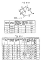
- Fig. 4 shows views illustrating examples of a road network, intersection data, road data and node series data.
- intersection data will have the data configuration shown in (b) of Fig. 4, the road data will have the data configuration shown in (c), and the node data will have the data configuration shown in (d) in a case where a road network comprises, e.g., road numbers 1 - 8 and intersection numbers I - IV as shown in Fig. 4(a).
- the intersection data comprises intersection names corresponding to the intersections numbers I - IV, road numbers having the smallest numbers among those roads possessing a certain intersection as a starting point, road numbers having the smallest numbers among those roads possessing a certain intersection as an end point, and information indicating whether or not a certain intersection has a traffic signal.
- the road data comprises starting and end points, in the form of intersection numbers, of the road numbers 1 through 8, the numbers of roads having the same starting point, the numbers of roads having the same end point, road width, information relating to prohibitions, information relating to guidance not required, photograph numbers, the numbers of nodes, the leading addresses of node series data, length, etc.
- the node array data comprises information relating to east longitude, north latitude, attributes and the like.
- the units of the road numbers comprise a plurality of nodes, as is evident from the road data. More specifically, the node data is data relating to one point on a road. If a line connecting nodes is referred to as an arc, a road is expressed by connecting each of a plurality of node arrays by arcs. For example, with regard to road number 1, the road comprises 15 nodes and the leading address of the node array data is 100, based on the road data. Therefore, road number 1 is composed of node data having addresses 100 to 114.
- intersection number I intersection number I
- first road number 1 is retrieved from the starting point information of the intersection point data
- road number 7 is retrieved from the road data relating to the road number 1, namely from the column reading "NO. OF ROAD HAVING SAME STARTING POINT". Since the same information for road number 7 will, in converse fashion, lead to retrieval of road number 1, it can be determined that there are no other road numbers available as peripheral roads. The same will hold true with regard to end points.
- road number 6 will be prohibited in case of road number 5 in the road data, the vehicle will not be able to enter road number 6 from road number 5 at the intersection number IV shown in Fig. 4(a) because turns are prohibited at this intersection.
- the only road that can be entered is the road number 8. Accordingly, guidance to road number 8 is unnecessary.
- the course exploration unit 13 Upon being provided with inputs of present position and destination, the course exploration unit 13 performs course exploration by referring to the intersection data, road data and node data mentioned above.
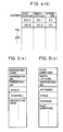
- Fig. 5 illustrates data generated by course retrieval, in which (a) is intersection series data and (b) is node series data.
- the intersection series data comprise information such as intersection name, intersection number, photograph number of a photograph showing the characteristic scenery of the intersection, angle of turn, distance and the like.
- the node series data comprise information such as east longitude and north latitude representng a node position, intersection number, attribute, angle, distance and the like.
- these data comprise data indicative solely of intersections requiring guidance; data relating to intersections not requiring guidance are excluded. Accordingly, for navigation, it will suffice to read out at any time the course data, which are thus generated by the guidance processor 15, in conformity with the position of travel, and also read out, as necessary, photograph data and map data and display these on the display unit 31.
- vehicle travel is accurately grasped while precisely identifying present position at all times based on the intersection data, road data and node series data.
- a parking lot exit where the vehicle is usually parked is inputted as the starting point, namely the position at which the vehicle is initially located (step 101).
- detection values are read in from the distance sensor and steering angle sensor (steps 102, 103), and the amount of change in the value detected by the distance sensor is computed (step 104). If it is detected that the vehicle is travelling without the amount of change in the value detected by the distance sensor being 0, a curve detection routine, described below, is traversed (step 106). If a curve is not detected between intersections, present position is calculated by the distance sensor on the assumption that the vehicle is proceeding along the course without turning.
- a curve is detected, whether or not the same type of curve is present on the course near the present position is investigated by comparing angles based on the node series data and calculating the difference between angles. If the same type of curve is present, a decision is rendered to the effect that the vehicle is travelling on the course; if such a curve is absent, a decision is rendered to the effect that the vehicle has gone off course. In a case where a curve is detected in the vicinity of a guidance intersection at which a turn should be made, it is decided that the vehicle made a turn on the course in the correct direction if the difference between the angle in the direction of travel and a detected angle is less than a fixed value; if the difference between the angles is greater, then it is decided that the vehicle is off course.
- the program enters the curve detection routine at a start step 201 and determines whether the steering angle is greater than a predetermined value a (step 202). If the steering angle is greater, a change ⁇ in the direction of travel commensurate with the present steering angle is added to the last heading of the vehicle (step 204), and it is determined from the travelling distance data whether the present position is within the detection range L from the intersection at which a turn should be made (step 205). If the present position is within the range L, a range-in curve detection flag is turned ON (step 206). If the present position is not within the range L, then the range-in curve detection flag is turned OFF (step 207). Next, it is determined whether the steering angle ⁇ is maximum or not (step 208).
- a distance counter is initialized (step 209) in order to count the distance from the point at which the steering angle is maximum. If the steering angle is not maximum, then it is determined that a turn was not made at the intersection and distance d is added on (step 210), after which the program proceeds to step 211. This processing is such that if the vehicle is turned correctly at an intersection where the turn should be made, a distance correction is applied with the point of maximum steering angle serving as the intersection, after which distance from this point is calculated to obtain the present position.
- step 203 it is determined whether the integrated value of the change in travelling direction calculated based on the steering angle - travelling direction conversion table is greater than a predetermined value b (step 203). If the change in travelling direction is greater than the predetermined value, the program jumps to step 210. If it is determined at step 203 that the change in heading is not greater than the predetermined value, each parameter value is initialized and it is determined whether the vehicle has gone past the range L of the guidance intersection (step 222). If it has, an off-course flag is turned ON; if it has not, the program returns.
- step 211 it is determined at step 211 whether the vehicle has travelled by more than l after the steering angle has become smaller than the value a. If it has not travelled by more than l, the program jumps to step 224 and returns. If the vehicle has travelled by more than l, it is judged that the steering wheel has been returned to end the left or right turn and then it is determined whether the integrated value of the change in travelling direction calculated based on the steering angle - travelling direction conversion table is greater than the predetermined value b, thereby judging whether the change in travelling direction is greater than the predetermined value (step 212). If the value is smaller than the predetermined value b, each parameter value is initialized and it is determined whether the vehicle has gone past the range L of the guidance intersection (step 222).
- an off-course flag is turned ON; if it has not, the program returns. If the change in travelling direction is greater than the predetermined value at step 212, it is determined whether the range-in curve detection flag is ON (step 213). When the flag is ON, it is determined whether the difference between the road intersection angle at the intersection at which a turn should be made and the detected angle is less than a fixed value c (step 214). If the difference is greater than the fixed value, it is decided that the vehicle has strayed off course by turning in the wrong direction and the off-course flag is turned ON (step 220).
- step 225 If the difference is less than the fixed value, it is decided that the vehicle turned correctly at the intersection where the turn should be made (step 225), a value obtained by subtracting the distance d from the point of maximum steering angle from the distance to the next intersection is adopted as remaining distance (step 226), each parameter value is initialized (step 221) and it is determined that the vehicle has not gone past the range L of the guidance intersection. Accordingly, the program returns.
- step 217 When the vehicle is not in the vicinity of a guidance intersection and the range-in curve detection flag is not ON at step 213, all nodes at the remaining distance ⁇ ⁇ are investigated (step 217) and it is determined whether there is a node at which the difference between an integrated value of bearing and the angle is less than a fixed value (step 218). When there is such a node, it is judged that the vehicle is not off course but is on a curve along the course which does not call for a left or right turn at the intersection. As a result, the program returns. When there is no node satisfying the foregoing conditions, it is judged that the vehicle has strayed off course due to a turn at the wrong intersection (step 219).
- the foregoing processing makes it possible to detect that the vehicle is off course by curve detection at a guidance intersection as well as between guidance intersections.
- the program enters the off-course routine at a start step 301, and it is determined whether the vehicle has passed through an intersection at which a turn should be made, turned at the wrong intersection or turned in the wrong direction (step 302).
- an off-course display indicating this fact is presented, as illustrated in Fig. 9(a), and a voice track is broadcast to the inform of the fact that the vehicle has gone off course by passing through the intersection (steps 303, 304).
- an off-course display indicating this fact is presented and a voice track is broadcast to the inform of the fact that the vehicle has gone off course (steps 307, 308).
- a display is presented calling for the vehicle to be stopped, and it is determined whether the vehicle has stopped (step 309). Distance from the point at which the vehicle went off course is added up until the vehicle stops (step 310). When the vehicle has stopped, it is determined whether there is data relating to a guidance intersection in the vicinity (step 311). When such guidance intersection data exists, a display to the effect that course exploration is in progress is presented on the screen, as shown in Fig. 9(b), and course exploration is performed (steps 312, 313). It is then determined whether a new course exists (step 314).
- the distance remaining to the destination on the new course is compared with a distance calculated by multiplying the distance remaining to the destination on the course traversed so far by a coefficient, e.g., 1.5 (step 317). If the new course is not longer, a message screen having the course is displayed, as shown in Fig. 9(d) (step 318), and travel starts (step 319). If no intersection is found at step 311, no course is found at step 314 or the new course is longer than the distance obtained by multiplying the remaining distance by the coefficient, then a message indicating the absence of a course and an instruction message indicating that the vehicle should return to the point at which it went off course and that "RESTART" should be touched are displayed, as shown in Fig. 9(c) (step 315). The vehicle is returned to the point at which it went off course and "RESTART" is entered by the touch panel (step 316). This makes it possible to return to navigation on the original course.
- a coefficient e.g. 1.5
- a curve detected by a steering angle sensor and distance sensor is compared with an angle at a guidance intersection or node, thereby determining whether the vehicle has turned at an intersection or node on the course.
- a distance correction is performed based upon the intersection or node at which the correct turn was made, distance from the intersection at which the last turn was made is calculated and present position is thus obtained. Since the steering angle sensor is employed as a sensor, there is no influence from external disturbances so that present position can be confirmed precisely and through a simple arrangement. Since node data are used, a correction can be performed with little course data so that processing speed can be greatly improved.
- the driver In a case where it is determined based on intersection data and node data that the vehicle has strayed off the predetermined course, the driver is informed of the fact and is given subsequent instructions. When necessary, the driver is guided along a new route or is instructed to return to the point at which the vehicle went off course. As a result, the driver immediately knows when the vehicle goes off course and suitable instructions are given without it always being required that the vehicle return to a previously traversed point. By obeying the instructions given, the driver can arrive at the destination quickly and is capable of driving the vehicle without anxiety.
- the vehicular navigation apparatus of the present invention enables the driver to be informed of present position with facility even when travelling in a region in which guidance is not provided. If the vehicle should stray from a predetermined course, instructions are given for subsequent actions so that the driver can travel to the destination with assurance.
- the invention therefore is applicable to various vehicles such as rental cars, taxis and ordinary passanger cars.
Abstract
Description
- This invention relates to a vehicular navigation apparatus for navigating in accordance with a predetermined route. The navigation apparatus is adapted to enter a number of characteristic points on a course as node data, compare an angle at which the vehicle is to turn at a guidance intersection or node with a detected angle of a turn actually made, calculate present position by performing a distance correction on the assumption that a turn has been made at the intersection or node at which the turn is to be made if the difference between the angles is less than a predetermined value, detect that the vehicle has strayed off course and, if the vehicle is off course, provide instructions with regard to subsequent measures or new course guidance.
- Conventionally, a vehicular navigation apparatus is equipped with a distance sensor for detecting the travelling distance of the vehicle, an orientation sensor such as a geomagnetic sensor or gyro for detecting the travelling bearing of the vehicle, and a map memory device comprising a video disk, video tape CDROM or the like. In the proposed apparatus, map data of a specific region are read out of the map memory device as necessary to display a map image, the travelling trajectory and present position of the vehicle are displayed on the displayed image, the driver visually verifies the vehicle position and confirms the present position, and the present position obtained is compared with the map data to revise the present position or inform the driver, as by means of a buzzer, whether the vehicle has strayed from a predetermined course.
- However, if geomagnetism is detected by a geomagnetic sensor in a system in which a predetermined course of travel and the travelling trajectory are displayed, errors in bearing detection can arise at locations where there is magnetic disturbance, as at railroad crossings, along railways and near high-tension lines, or due to magnetization of the vehicle body. As a result, present position cannot be detected with very good precision. In addition, gyros are high in cost. Furthermore, the method of correcting present position by comparing calculated values with map data involves large quantities of data and considerable processing time.
- Furthermore, since the vehicle must be driven while the operator constantly verifies whether the vehicle is travelling in accordance with the predetermined course or whether the vehicle has strayed off course, a hazardous situation arises in which the driver is not capable of paying full attention to driving.
- With the system in which it is determined whether the vehicle has strayed off the predetermined course and the driver is so informed by a buzzer, there are no instructions given to the driver with regard to what should be done from the point at which the vehicle has gone astray. Consequently, it is difficult for the driver to return and pick up the predetermined course.
- GB-A-21 80 066 discloses a vehicle navigation system comprising means for receiving data indicating vehicle position, means for storing data representing a road network, means for measuring distance travel by a vehicle, means for measuring angle turned through by the vehicle, processing means for processing data from the distance measuring means, the angle measuring means and the data receiving means and for supplying output data, and output means for supplying the output data in a form discernable by the driver. However, there is no mention about means for re-exploring a new course in case the vehicle has strayed off course.
- EP-A3-0 120 195 relates to a vehicle running guide system comprising a distance detector, means for detecting any right and left turns as special condition, memory means for storing distance data, guide data and special conditions data, means for effecting decisions, announcing means for announcing that the vehicle is displaced from a planned running route and restoration means for restoring the vehicle from a wrong route to said planned route. Should the vehicle have strayed off course, the guide system guides the vehicle back to the planned route (e.g., page 16,
lines 3 to 18 and Figs. 4a, b, c). A re-exploration of a new course is not provided. - The present invention has been devised in order to solve the aforementioned problems and its object is to provide a vehicular navigation apparatus in which distance can be revised accurately at every intersection without being affected by disturbances, present position is calculated with little data, processing speed is improved, straying off course can be quickly determined, it is unnecessary to return to a previously traversed point when a new course is found, it is possible to promptly return to the point at which the vehicle went astray if a new course cannot be found, and the driver is capable of driving the vehicle safely.
- To these ends, the vehicular navigation apparatus of the present invention comprises a distance sensor, a steering angle sensor, a curve detecting unit provided with inputs of a distance signal and steering-angle signal for calculating a change in vehicle travelling direction by referring to a steering angle - travelling direction conversion table, a course exploration unit provided with inputs of present position and destination for performing course exploration based on intersection data, road data and node data, a comparison-decision unit for comparing retrieved course data and results of curve detection, and a guidance processor for executing predetermined guidance processing based on the results of comparison.
- Thus, the present invention is adapted to compare the angle of a turn to be made at a guidance intersection or node on a course with a detected angle, determine, depending upon whether a difference between the angles is less than a predetermined value, if the vehicle has turned at an intersection or node at which a turn is to be made on the course, passed through the intersection or node or turned in the wrong direction at the intersection or node, and calculate, if the turn has been made correctly, the present position by performing a distance correction using the intersection position data or node data. This makes it possible to calculate present position accurately through an inexpensive arrangement using little course data without external influence, and to raise processing speed.
- Further, it is determined whether the vehicle is on the predetermined course by comparing the predetermined course data and the result of curve detection. When it is judged that the vehicle has strayed off course, the driver is informed by a display or voice track of whether the vehicle has passed through the intersection at which a turn was to be made, turned at the wrong intersection or turned in the wrong direction, and an instruction is given to stop the vehicle. If a new course can be found upon performing course exploration from the point at which the vehicle is stopped to the destination, the new course and the original course are compared and instructions are given, in accordance with the results of the comparison, to travel based on the new course or to return to the point at which the vehicle strayed off course. When a new course cannot be found, instructions are given to return to the point at which the vehicle strayed of course. Thus, the fact that the vehicle has strayed off course can be quickly determined. If a new course can be found, it is not always necessary for the vehicle to return to a previously traversed point. If a new course cannot be found, the vehicle can quickly return to the point at which it went astray. The driver is thus capable of driving at ease by obeying the instructions given.
- Fig. 1 is a view illustrating the construction of a vehicular navigation apparatus having means for providing guidance when the vehicle is off course in accordance with the present invention;
- Fig. 2 is a view illustrating a change in travelling direction, per unit distance, versus to steering angle;
- Fig. 3 is a view for describing calculation of a change in travelling direction;
- Fig. 4(a) is a view of a road network, (b) intersection data, (c) road data, and (d) node series data;
- Fig. 5(a) is a view of retrieved guidance intersection data, and (b) a view of retrieved course node series data;
- Figs. 6, 7 and 8 are views for describing navigation processing according to the invention; and
- Fig. 9 is a view for describing guidance instructions when the vehicle is off course.
- Fig. 1 is a view illustrating the construction of a vehicular navigation apparatus according to the present invention, in which
numeral 1 denotes a distance sensor, 3 a steering angle sensor, 5 a present location/destination input unit, 7 a navigation processing unit, 9 a curve detector, 11 a comparison - decision unit, 13 a course exploration unit, 15 a guidance precessor, 17 a steering angle - travelling direction conversion table, 19 an intersection data file, 21 a node data file, 23 a road data file, 25 an exploration course data file, 27 a photograph data file, 29 a map data file, 31 a display unit and 33 a voice output unit. - The
distance sensor 1 measures the travelling distance of a vehicle. For example, the distance sensor can be one which senses and counts the revolution of a wheel, or which senses acceleration and subjects the result to double integration. Other measuring means may be employed as well. Thesteering angle sensor 3 senses whether or not a turn has been made at an intersection. For example, this can be an optical rotation sensor or rotatable resistor mounted on a rotating portion of a steering wheel, or an angle sensor mounted on a wheel portion. The present location/destination input unit 5 is a joy stick, key or touch panel, or means coupled with the screen of adisplay unit 8 for displaying keys or a menu on the screen so that inputs can be made from the screen. - The
navigation processing unit 7 forms the nucleus of the navigation apparatus and has thecurve detector 9, comparison/decision unit 11, acourse exploration unit 13 and aguidance processor 15. - The
course guidance unit 13 is so adapted that when present location and destination are entered from theinput unit 5, course search is performed upon reading intersection data, node data and road data, of the kind described below, out of respective files, and the searched course is stored in thefile 25. As will be described below, thecurve detector 9 reads detection outputs from thedistance sensor 1 andsteering angle sensor 3 and detects a change in vehicle heading upon referring to the steering angle - travelling direction conversion table 17. - The comparison/
decision unit 11 compares the angle of an intersection or the angle of a node on a course, which has been retrieved in the vicinity of a guidance intersection or between guidance intersections on the course, with an angle detected by thecurve detector 9 and, if the difference between the two angles is less than a predetermined value, decides that a turn has been made correctely at an intersection or node. Further, the comparison/decision unit 11 determines whether or not the vehicle is travelling along the course by comparing course data, which has been retrieved in the vicinity of a guidance intersection or between guidance intersections on the course, and travel data from thecurve detector 9. - The
guidance processor 15 calculates present position by performing a distance correction using intersection data or node data when it has been decided by the comparison/decision unit 11 that a turn has been made correctly. Present position in this case is calculated as the distance from the intersection at which the last turn was made. Further, when necessary, theguidance processor 15 displays the calculated present position or causes a voice track indicative thereof to be produced. In addition, the guidance processor executes processing for successively projecting guidance intersections of a retrieved course or characterizing photographs along the course, displaying guidance maps, displaying distance remaining to the next intersection and other guidance information, broadcasting guidance by voice from thevoice output unit 25, displaying a message to the effect that the vehicle has strayed off course when this event is detected, or informing the driver by voice that the vehicle has strayed off course, and providing the driver with subsequent instructions, as will be set forth later. - The processing performed by the curve detector will now be described with reference to Figs. 2 and 3.
- Upon receiving inputs of detection signals from the
distance sensor 1 andsteering angle sensor 3, thecurve detector 9 calculates a change in the travelling direction of the vehicle by referring to the steering angle - travelling direction conversion table 17. As shown in Fig. 2, the steering angle - travelling direction conversion table 17 is for converting steering angle θ into a change Δα in travelling direction per unit of distance. As shown in Fig. 3, thecurve detector 9 adds up (integrates) Δα with respect to the detected steering angle from the moment the steering angle exceeds a certain threshold value a until the moment the steering angle returns to the threshold value. How much the travelling direction of the vehicle changes from the moment the steering wheel starts being turned until the moment the steering wheel returns is calculated based on the integrated value. In Fig. 3, L represents intersection detection range, ℓ denotes a fixed distance travelled after the steering wheel is returned, this taking into account a lane change or the like within examination limits following angle detection, and d represents distance travelled from a turning point until a decision is rendered. - The comparison/
decision unit 11 compares the calculated change in travelling direction and the intersection angle of the road at an intersection angle at which a turn is to be made (which angle is read out of each file), namely the direction in which the vehicle is to proceed, and checks to see whether there is a difference in excess of a predetermined value between these compared quantities. If the difference is less than the predetermined value, it is judged that the vehicle turned at an intersection or node at which the turn was to be made. If the difference is greater than the predetermined value, it is judged that a turn was made at the wrong intersection. The results are displayed on thedisplay unit 8 or indicated to the driver by voice using thespeaker 10. - Intersection data, node data and road data used in course exploration will now be described.
- The intersection data constitute information such as the roads that cross at an intersection, the node data constitute information regarding pedestrian crossings and tunnels that can be detected by sensors at characteristic points along the course, and the road data constitute information relating to starting points, end points and the roads between them.
- Fig. 4 shows views illustrating examples of a road network, intersection data, road data and node series data.
- In order for the driver to accurately grasp vehicle distance from the present position to the destination at all times, the intersection data will have the data configuration shown in (b) of Fig. 4, the road data will have the data configuration shown in (c), and the node data will have the data configuration shown in (d) in a case where a road network comprises, e.g., road numbers ① - ⑧ and intersection numbers I - IV as shown in Fig. 4(a).
- Specifically, as shown in (b) of Fig. 4, the intersection data comprises intersection names corresponding to the intersections numbers I - IV, road numbers having the smallest numbers among those roads possessing a certain intersection as a starting point, road numbers having the smallest numbers among those roads possessing a certain intersection as an end point, and information indicating whether or not a certain intersection has a traffic signal.
- As shown in (c) of Fig. 4, the road data comprises starting and end points, in the form of intersection numbers, of the
road numbers ① through ⑧, the numbers of roads having the same starting point, the numbers of roads having the same end point, road width, information relating to prohibitions, information relating to guidance not required, photograph numbers, the numbers of nodes, the leading addresses of node series data, length, etc. - As shown in (d) of Fig. 4, the node array data comprises information relating to east longitude, north latitude, attributes and the like. The units of the road numbers comprise a plurality of nodes, as is evident from the road data. More specifically, the node data is data relating to one point on a road. If a line connecting nodes is referred to as an arc, a road is expressed by connecting each of a plurality of node arrays by arcs. For example, with regard to
road number ①, the road comprises 15 nodes and the leading address of the node array data is 100, based on the road data. Therefore,road number ① is composed of nodedata having addresses 100 to 114. - Assume a case where the intersection is intersection number I, for example. For a course having this intersection as a starting point, in accordance with these network data,
first road number ① is retrieved from the starting point information of the intersection point data, then road number ⑦is retrieved from the road data relating to theroad number ①, namely from the column reading "NO. OF ROAD HAVING SAME STARTING POINT". Since the same information forroad number ⑦ will, in converse fashion, lead to retrieval ofroad number ①, it can be determined that there are no other road numbers available as peripheral roads. The same will hold true with regard to end points. Further, sinceroad number ⑥ will be prohibited in case ofroad number ⑤ in the road data, the vehicle will not be able to enterroad number ⑥ fromroad number ⑤ at the intersection number IV shown in Fig. 4(a) because turns are prohibited at this intersection. The only road that can be entered is theroad number ⑧. Accordingly, guidance toroad number ⑧ is unnecessary. - Upon being provided with inputs of present position and destination, the
course exploration unit 13 performs course exploration by referring to the intersection data, road data and node data mentioned above. - Fig. 5 illustrates data generated by course retrieval, in which (a) is intersection series data and (b) is node series data. The intersection series data comprise information such as intersection name, intersection number, photograph number of a photograph showing the characteristic scenery of the intersection, angle of turn, distance and the like. The node series data comprise information such as east longitude and north latitude representng a node position, intersection number, attribute, angle, distance and the like. Moreover, these data comprise data indicative solely of intersections requiring guidance; data relating to intersections not requiring guidance are excluded. Accordingly, for navigation, it will suffice to read out at any time the course data, which are thus generated by the
guidance processor 15, in conformity with the position of travel, and also read out, as necessary, photograph data and map data and display these on thedisplay unit 31. - Thus, in accordance with the invention, vehicle travel is accurately grasped while precisely identifying present position at all times based on the intersection data, road data and node series data.
- Navigation according to the present invention will now be described in accordance with the flowchart of Fig. 6.
- First, a parking lot exit where the vehicle is usually parked is inputted as the starting point, namely the position at which the vehicle is initially located (step 101). Next, detection values are read in from the distance sensor and steering angle sensor (
steps 102, 103), and the amount of change in the value detected by the distance sensor is computed (step 104). If it is detected that the vehicle is travelling without the amount of change in the value detected by the distance sensor being 0, a curve detection routine, described below, is traversed (step 106). If a curve is not detected between intersections, present position is calculated by the distance sensor on the assumption that the vehicle is proceeding along the course without turning. If a curve is detected, whether or not the same type of curve is present on the course near the present position is investigated by comparing angles based on the node series data and calculating the difference between angles. If the same type of curve is present, a decision is rendered to the effect that the vehicle is travelling on the course; if such a curve is absent, a decision is rendered to the effect that the vehicle has gone off course. In a case where a curve is detected in the vicinity of a guidance intersection at which a turn should be made, it is decided that the vehicle made a turn on the course in the correct direction if the difference between the angle in the direction of travel and a detected angle is less than a fixed value; if the difference between the angles is greater, then it is decided that the vehicle is off course. In a case where a curve is not detected even when the vehicle advances a fixed distance through the vicinity of an intersection, it is judged that the vehicle has strayed off course by passing through the intersection. After these off-course routines are traversed (steps 107, 108), travelled distance is subtracted from distance remaining to the next intersection (step 109) to calculate present position, and a display is presented for guidance to the next intersection. By repeating this processing, the vehicle will arrive at the entrance to the parking lot at the destination (step 110). - The curve detection routine will be described based on Fig. 7.
- First, the program enters the curve detection routine at a
start step 201 and determines whether the steering angle is greater than a predetermined value a (step 202). If the steering angle is greater, a change Δα in the direction of travel commensurate with the present steering angle is added to the last heading of the vehicle (step 204), and it is determined from the travelling distance data whether the present position is within the detection range L from the intersection at which a turn should be made (step 205). If the present position is within the range L, a range-in curve detection flag is turned ON (step 206). If the present position is not within the range L, then the range-in curve detection flag is turned OFF (step 207). Next, it is determined whether the steering angle θ is maximum or not (step 208). When the steering angle is maximum, a distance counter is initialized (step 209) in order to count the distance from the point at which the steering angle is maximum. If the steering angle is not maximum, then it is determined that a turn was not made at the intersection and distance d is added on (step 210), after which the program proceeds to step 211. This processing is such that if the vehicle is turned correctly at an intersection where the turn should be made, a distance correction is applied with the point of maximum steering angle serving as the intersection, after which distance from this point is calculated to obtain the present position. In a case where the steering angle is-found to be less than the predetermined value a (no left or right turn) atstep 202, it is determined whether the integrated value of the change in travelling direction calculated based on the steering angle - travelling direction conversion table is greater than a predetermined value b (step 203). If the change in travelling direction is greater than the predetermined value, the program jumps to step 210. If it is determined atstep 203 that the change in heading is not greater than the predetermined value, each parameter value is initialized and it is determined whether the vehicle has gone past the range L of the guidance intersection (step 222). If it has, an off-course flag is turned ON; if it has not, the program returns. - Next, it is determined at
step 211 whether the vehicle has travelled by more than ℓ after the steering angle has become smaller than the value a. If it has not travelled by more than ℓ, the program jumps to step 224 and returns. If the vehicle has travelled by more than ℓ, it is judged that the steering wheel has been returned to end the left or right turn and then it is determined whether the integrated value of the change in travelling direction calculated based on the steering angle - travelling direction conversion table is greater than the predetermined value b, thereby judging whether the change in travelling direction is greater than the predetermined value (step 212). If the value is smaller than the predetermined value b, each parameter value is initialized and it is determined whether the vehicle has gone past the range L of the guidance intersection (step 222). If it has, an off-course flag is turned ON; if it has not, the program returns. If the change in travelling direction is greater than the predetermined value atstep 212, it is determined whether the range-in curve detection flag is ON (step 213). When the flag is ON, it is determined whether the difference between the road intersection angle at the intersection at which a turn should be made and the detected angle is less than a fixed value c (step 214). If the difference is greater than the fixed value, it is decided that the vehicle has strayed off course by turning in the wrong direction and the off-course flag is turned ON (step 220). If the difference is less than the fixed value, it is decided that the vehicle turned correctly at the intersection where the turn should be made (step 225), a value obtained by subtracting the distance d from the point of maximum steering angle from the distance to the next intersection is adopted as remaining distance (step 226), each parameter value is initialized (step 221) and it is determined that the vehicle has not gone past the range L of the guidance intersection. Accordingly, the program returns. - When the vehicle is not in the vicinity of a guidance intersection and the range-in curve detection flag is not ON at
step 213, all nodes at the remaining distance ± α are investigated (step 217) and it is determined whether there is a node at which the difference between an integrated value of bearing and the angle is less than a fixed value (step 218). When there is such a node, it is judged that the vehicle is not off course but is on a curve along the course which does not call for a left or right turn at the intersection. As a result, the program returns. When there is no node satisfying the foregoing conditions, it is judged that the vehicle has strayed off course due to a turn at the wrong intersection (step 219). - The foregoing processing makes it possible to detect that the vehicle is off course by curve detection at a guidance intersection as well as between guidance intersections.
- The off-course routine will now be described with reference to Fig. 8.
- The program enters the off-course routine at a
start step 301, and it is determined whether the vehicle has passed through an intersection at which a turn should be made, turned at the wrong intersection or turned in the wrong direction (step 302). When it is judged that the vehicle has passed through an intersection at which a turn should be made (seestep 223 in Fig 7), an off-course display indicating this fact is presented, as illustrated in Fig. 9(a), and a voice track is broadcast to the inform of the fact that the vehicle has gone off course by passing through the intersection (steps 303, 304). When it is judged that the vehicle has turned in the wrong direction (seestep 220 in Fig. 7), an off-course display indicating this fact is presented and a voice track is broadcast to the inform of the fact that the vehicle has gone off course (steps 307, 308). - In either case, when the vehicle strays off course, a display is presented calling for the vehicle to be stopped, and it is determined whether the vehicle has stopped (step 309). Distance from the point at which the vehicle went off course is added up until the vehicle stops (step 310). When the vehicle has stopped, it is determined whether there is data relating to a guidance intersection in the vicinity (step 311). When such guidance intersection data exists, a display to the effect that course exploration is in progress is presented on the screen, as shown in Fig. 9(b), and course exploration is performed (
steps 312, 313). It is then determined whether a new course exists (step 314). If there is such a course, the distance remaining to the destination on the new course is compared with a distance calculated by multiplying the distance remaining to the destination on the course traversed so far by a coefficient, e.g., 1.5 (step 317). If the new course is not longer, a message screen having the course is displayed, as shown in Fig. 9(d) (step 318), and travel starts (step 319). If no intersection is found at step 311, no course is found atstep 314 or the new course is longer than the distance obtained by multiplying the remaining distance by the coefficient, then a message indicating the absence of a course and an instruction message indicating that the vehicle should return to the point at which it went off course and that "RESTART" should be touched are displayed, as shown in Fig. 9(c) (step 315). The vehicle is returned to the point at which it went off course and "RESTART" is entered by the touch panel (step 316). This makes it possible to return to navigation on the original course. - In accordance with the present invention as described above, a curve detected by a steering angle sensor and distance sensor is compared with an angle at a guidance intersection or node, thereby determining whether the vehicle has turned at an intersection or node on the course. A distance correction is performed based upon the intersection or node at which the correct turn was made, distance from the intersection at which the last turn was made is calculated and present position is thus obtained. Since the steering angle sensor is employed as a sensor, there is no influence from external disturbances so that present position can be confirmed precisely and through a simple arrangement. Since node data are used, a correction can be performed with little course data so that processing speed can be greatly improved.
- In a case where it is determined based on intersection data and node data that the vehicle has strayed off the predetermined course, the driver is informed of the fact and is given subsequent instructions. When necessary, the driver is guided along a new route or is instructed to return to the point at which the vehicle went off course. As a result, the driver immediately knows when the vehicle goes off course and suitable instructions are given without it always being required that the vehicle return to a previously traversed point. By obeying the instructions given, the driver can arrive at the destination quickly and is capable of driving the vehicle without anxiety.
- The vehicular navigation apparatus of the present invention enables the driver to be informed of present position with facility even when travelling in a region in which guidance is not provided. If the vehicle should stray from a predetermined course, instructions are given for subsequent actions so that the driver can travel to the destination with assurance. The invention therefore is applicable to various vehicles such as rental cars, taxis and ordinary passanger cars.
Claims (9)
- Navigation method comprising the following steps:a) course exploration for generating course data from a present position to a destination, based on intersection data, road data and node datab) providing a driver with the guidance information,c) comparing the course data with measured travel data, representing change in travelling direction as calculated from measured travelled distance and steering angled) deciding whether or not the vehicle is travelling along the course,e) providing the driver with an instruction to stop the vehicle if it is decided that the vehicle has strayed off course,f) once the vehicle has stopped, exploring a new course from the calculated location at which the vehicle has stopped to the original destination,g) comparing the new course to the original course, andh) in dependence on the result of said comparison, providing the driver with instructions either to continue travel in accordance with the new course or to return to the point where the vehicle strayed off the original course and to continue along that course.
- A navigation apparatus comprising:a) a distance sonsor (1) for detecting distance travelled and for generating a distance signal;b) a vehicle travelling angle sensor (3) for generating a signal for vehicle travelling angle;c) a curve detecting unit (9) provided with inputs of the distance signal and the vehicle travelling angle signal for calculating a change in vehicle travelling direction;d) an exploration unit (13) for performing course exploration based on intersection data, road date and node data, and for generating course data from the present position to the destination;e) a comparison-decision unit (11) for comparing said course data explored by said exploration unit with travel data from said curve detecting unit, and for deciding whether or not the vehicle is travelling along the course;f) a guidance processor unit (15) for providing the driver with guidance information and instructions;
characterized in thatg) the guidance processor unit (15) is adapted to inform the driver about "OFF-COURSE" when it is judged that the vehicle has strayed off the course to then instruct the driver to stop the vehicle;h) said exploration unit (13) is adapted to re-explore a new course from the present stopped position to the destination when it is judged that the vehicle has strayed off the course;i) means are provided for comparing the new course to the original course and in dependence on the result of said comparison providing the driver with instructions either to continue travel in accordance with the new course or to return to the point where the vehicle strayed off the course and to continue along that course. - Apparatus according to Claim 2 wherein said curve detecting unit (9) is adapted to calculate a change in vehicle travelling direction by referring to a steering angle-travelling direction conversion table (17).
- Apparatus according to claim 2 or 3, wherein said re-exploration unit (313) is adapted to guide course for return to the point of strayed off course when new course from present position to destination can not be found.
- Apparatus according to any of claims 2 to 4, wherein the guidance processor unit (15) is adapted to calculate the present position by performing a distance correction based on intersection position data or node position data when the difference between an angle of an intersection or node of a retrieved course and the results of curve detection is less than a predetermined value.
- Apparatus according to claim 5, adapted for performing of distance computation with the intersection position being taken as a geographical point at which steering angle is maximum during detection of a curve.
- Apparatus according to any of claims 2 to 6, wherein the guidance processor unit (15) is adapted to provide an off-course indication and instructions for subsequent countermeasures when it is determined that the vehicle is not on a predetermined course by comparing retrieved course data and the results of curve detection.
- Apparatus according to claim 7, adapted to give the off-course indication and the instructions for subsequent countermeasures provided by the guidance processor unit (15) in the form of a display or voice output.
- Apparatus according to any of claims 2 to 8, wherein, the guidance processor unit (15) is adapted to compare the new course and an original course and, based on the results of the comparison, to give instructions to travel in accordance with the new course or to return to a geographical point at which the vehicle went off course when the vehicle is detected to be off course, the vehicle is stopped and a new course from a geographical point at which the vehicle is stopped to a destination is found.
Applications Claiming Priority (5)
| Application Number | Priority Date | Filing Date | Title |
|---|---|---|---|
| JP333046/87 | 1987-12-28 | ||
| JP62333045A JP2653803B2 (en) | 1987-12-28 | 1987-12-28 | Vehicle navigation system |
| JP333045/87 | 1987-12-28 | ||
| JP62333046A JP2692822B2 (en) | 1987-12-28 | 1987-12-28 | Vehicle navigation system |
| PCT/JP1988/001302 WO1989006342A1 (en) | 1987-12-28 | 1988-12-23 | Vehicle navigation system |
Publications (3)
| Publication Number | Publication Date |
|---|---|
| EP0349652A1 EP0349652A1 (en) | 1990-01-10 |
| EP0349652A4 EP0349652A4 (en) | 1991-12-11 |
| EP0349652B1 true EP0349652B1 (en) | 1996-03-27 |
Family
ID=26574374
Family Applications (1)
| Application Number | Title | Priority Date | Filing Date |
|---|---|---|---|
| EP89900885A Expired - Lifetime EP0349652B1 (en) | 1987-12-28 | 1988-12-23 | Vehicle navigation system |
Country Status (4)
| Country | Link |
|---|---|
| US (1) | US5043902A (en) |
| EP (1) | EP0349652B1 (en) |
| DE (1) | DE3855162T2 (en) |
| WO (1) | WO1989006342A1 (en) |
Cited By (2)
| Publication number | Priority date | Publication date | Assignee | Title |
|---|---|---|---|---|
| US6812888B2 (en) | 1997-08-19 | 2004-11-02 | Siemens Vdo Automotive Corporation | Driver information system |
| US6968272B2 (en) | 1997-08-19 | 2005-11-22 | Siemens Vdo Automotive Corporation | Vehicle information system |
Families Citing this family (78)
| Publication number | Priority date | Publication date | Assignee | Title |
|---|---|---|---|---|
| EP0475935B1 (en) * | 1989-06-08 | 1994-09-07 | Robert Bosch Gmbh | Vehicle navigation system |
| DK0489915T4 (en) * | 1989-08-24 | 2000-07-31 | Toshio Tsuyuki | System and method of navigation |
| US5177685A (en) * | 1990-08-09 | 1993-01-05 | Massachusetts Institute Of Technology | Automobile navigation system using real time spoken driving instructions |
| JP2657581B2 (en) * | 1990-11-28 | 1997-09-24 | 本田技研工業株式会社 | Current position display device of moving object |
| EP0514887B1 (en) * | 1991-05-21 | 1997-04-16 | Matsushita Electric Industrial Co., Ltd. | Vehicle position detecting apparatus |
| US5828321A (en) * | 1991-06-18 | 1998-10-27 | Sumitomo Electric Industries, Ltd. | Location detecting system |
| JP2771911B2 (en) * | 1991-08-09 | 1998-07-02 | 三菱電機株式会社 | Car navigation system |
| US5546572A (en) * | 1991-08-28 | 1996-08-13 | Hitachi, Ltd. | Method for retrieving database of image information |
| EP0534892B1 (en) * | 1991-09-27 | 1996-05-22 | Nessim Igal Levy | Position-locating method |
| JP2554567B2 (en) * | 1991-10-02 | 1996-11-13 | スタンレー電気株式会社 | How to display road information |
| EP0542331B1 (en) * | 1991-10-29 | 1996-09-25 | Koninklijke Philips Electronics N.V. | Navigation device and vehicle comprising the device |
| JP3227741B2 (en) * | 1991-11-18 | 2001-11-12 | 住友電気工業株式会社 | Overspeed prediction device |
| US5181250A (en) * | 1991-11-27 | 1993-01-19 | Motorola, Inc. | Natural language generation system for producing natural language instructions |
| US10361802B1 (en) | 1999-02-01 | 2019-07-23 | Blanding Hovenweep, Llc | Adaptive pattern recognition based control system and method |
| US8352400B2 (en) | 1991-12-23 | 2013-01-08 | Hoffberg Steven M | Adaptive pattern recognition based controller apparatus and method and human-factored interface therefore |
| US5450325A (en) * | 1992-03-09 | 1995-09-12 | Rodriguez; Angel L. | Route directions display system |
| JP2973695B2 (en) * | 1992-03-12 | 1999-11-08 | 船井電機株式会社 | In-vehicle navigation system |
| US5262775A (en) * | 1992-04-07 | 1993-11-16 | Zexel Corporation | Navigation system with off-route detection and route recalculation |
| DE69323355T2 (en) * | 1992-07-20 | 1999-08-26 | Aisin Aw Co | Navigation device for vehicles with detection of curves and guidance of the vehicles by voice |
| DE69326643T2 (en) * | 1992-07-20 | 2000-04-13 | Aisin Aw Co | Navigation system for vehicle steering |
| EP0777204A1 (en) * | 1992-07-23 | 1997-06-04 | Toyota Jidosha Kabushiki Kaisha | Vehicle route guidance apparatus |
| EP0929058B1 (en) * | 1992-07-23 | 2005-11-23 | Aisin Aw Co., Ltd. | Vehicle route guidance apparatus for researching for a route when vehicle goes out of route |
| EP0580166B1 (en) * | 1992-07-23 | 1999-06-16 | Aisin Aw Co., Ltd. | Vehicle navigation system |
| EP1058222B1 (en) * | 1992-08-19 | 2005-12-07 | Aisin Aw Co., Ltd. | Navigation system for vehicles |
| JP3146736B2 (en) * | 1993-03-26 | 2001-03-19 | 株式会社デンソー | Touring progress confirmation system for vehicles |
| US5406491A (en) * | 1993-03-26 | 1995-04-11 | Trimble Navigation Limited | Navigational system for trip routing |
| US5548773A (en) * | 1993-03-30 | 1996-08-20 | The United States Of America As Represented By The Administrator Of The National Aeronautics And Space Administration | Digital parallel processor array for optimum path planning |
| US5550538A (en) * | 1993-07-14 | 1996-08-27 | Zexel Corporation | Navigation system |
| US5402120A (en) * | 1993-08-18 | 1995-03-28 | Zexel Corporation | Navigation system |
| DE4333112A1 (en) * | 1993-09-29 | 1995-03-30 | Bosch Gmbh Robert | Method and device for parking a vehicle |
| JP3366096B2 (en) * | 1994-02-16 | 2003-01-14 | 本田技研工業株式会社 | Vehicle travel control device |
| US7432830B2 (en) * | 1994-06-24 | 2008-10-07 | Navteq North America, Llc | Electronic navigation system and method |
| US5543789A (en) * | 1994-06-24 | 1996-08-06 | Shields Enterprises, Inc. | Computerized navigation system |
| EP0722559B1 (en) * | 1994-08-08 | 2001-07-18 | Mannesmann VDO Aktiengesellschaft | A navigation device for a land vehicle with means for generating a multi-element anticipatory speech message, and a vehicle comprising such device |
| US5757289A (en) * | 1994-09-14 | 1998-05-26 | Aisin Aw Co., Ltd. | Vehicular navigation system |
| JP3415298B2 (en) * | 1994-11-30 | 2003-06-09 | 本田技研工業株式会社 | Car navigation system |
| US5682525A (en) | 1995-01-11 | 1997-10-28 | Civix Corporation | System and methods for remotely accessing a selected group of items of interest from a database |
| JPH08201093A (en) * | 1995-01-20 | 1996-08-09 | Mitsubishi Electric Corp | Navigation system |
| JP3351650B2 (en) * | 1995-03-28 | 2002-12-03 | アルパイン株式会社 | Demonstration method of navigation device |
| JP3578511B2 (en) * | 1995-04-21 | 2004-10-20 | 株式会社ザナヴィ・インフォマティクス | Current position calculation device |
| DE59607547D1 (en) * | 1995-11-14 | 2001-09-27 | Mannesmann Ag | METHOD AND GUIDE UNIT FOR SAFE GUIDANCE OF A VEHICLE |
| US5928309A (en) * | 1996-02-05 | 1999-07-27 | Korver; Kelvin | Navigation/guidance system for a land-based vehicle |
| DE19629618A1 (en) * | 1996-07-23 | 1998-01-29 | Claas Ohg | Route planning system for agricultural work vehicles |
| KR100288284B1 (en) * | 1996-09-30 | 2001-05-02 | 모리 하루오 | Car Navigation |
| EP0944891A1 (en) * | 1996-12-16 | 1999-09-29 | MANNESMANN Aktiengesellschaft | Process for transmitting route information which defines a proposed route for a vehicle in a road network and serves as a navigation aid from a traffic information centre to a terminal in a vehicle, traffic information centre and terminal |
| DE69829699T2 (en) * | 1997-01-10 | 2006-01-19 | Siemens Ag | Navigation system for driving a driver |
| US5798733A (en) * | 1997-01-21 | 1998-08-25 | Northrop Grumman Corporation | Interactive position guidance apparatus and method for guiding a user to reach a predetermined target position |
| US5986547A (en) | 1997-03-03 | 1999-11-16 | Korver; Kelvin | Apparatus and method for improving the safety of railroad systems |
| US5844505A (en) * | 1997-04-01 | 1998-12-01 | Sony Corporation | Automobile navigation system |
| EP1005627B1 (en) * | 1997-08-19 | 2003-10-29 | Siemens VDO Automotive Corporation | Vehicle information system |
| US6199014B1 (en) * | 1997-12-23 | 2001-03-06 | Walker Digital, Llc | System for providing driving directions with visual cues |
| US7268700B1 (en) | 1998-01-27 | 2007-09-11 | Hoffberg Steven M | Mobile communication device |
| US6539080B1 (en) | 1998-07-14 | 2003-03-25 | Ameritech Corporation | Method and system for providing quick directions |
| DE19858297A1 (en) * | 1998-12-17 | 2000-06-29 | Daimler Chrysler Ag | Method for correcting a signal of at least one sensor, on the basis of which a path curve can be determined on which the vehicle is moving |
| US7904187B2 (en) | 1999-02-01 | 2011-03-08 | Hoffberg Steven M | Internet appliance system and method |
| JP3094106B1 (en) * | 1999-10-27 | 2000-10-03 | 建設省土木研究所長 | Lane departure prevention system |
| US6397145B1 (en) | 2000-03-06 | 2002-05-28 | Magellan Dis, Inc. | Navigation system with complex maneuver instruction |
| US6697752B1 (en) | 2000-05-19 | 2004-02-24 | K&L Technologies, Inc. | System, apparatus and method for testing navigation or guidance equipment |
| DE10129136A1 (en) * | 2001-06-16 | 2002-12-19 | Deere & Co | Device for the automatic steering of an agricultural work vehicle |
| JP2003172624A (en) * | 2001-12-10 | 2003-06-20 | Mitsubishi Electric Corp | Apparatus and method for searching intersection |
| US9818136B1 (en) | 2003-02-05 | 2017-11-14 | Steven M. Hoffberg | System and method for determining contingent relevance |
| JP4096180B2 (en) * | 2003-02-10 | 2008-06-04 | アイシン・エィ・ダブリュ株式会社 | NAVIGATION DEVICE, PROGRAM FOR THE DEVICE, AND RECORDING MEDIUM |
| EP1544829B1 (en) * | 2003-12-19 | 2017-02-15 | Samsung Electronics Co., Ltd. | Navigation system and navigation method |
| US20080275636A1 (en) * | 2004-03-26 | 2008-11-06 | Chihiro Hirose | Navigation Device, Route Searching Method, Route Searching Program, and Computer-Readable Recording Medium |
| DE102004035571B4 (en) * | 2004-07-22 | 2011-11-10 | Daimler Ag | Device and method for vehicle position determination by means of locating on a traffic route network |
| JP4213097B2 (en) * | 2004-09-13 | 2009-01-21 | 三菱電機株式会社 | Car navigation system |
| JP4683576B2 (en) | 2006-12-08 | 2011-05-18 | パイオニア株式会社 | Navigation device and navigation method |
| KR100974704B1 (en) * | 2007-04-30 | 2010-08-06 | 현대자동차주식회사 | Parking Guidance Method for Vehicle |
| US9285228B2 (en) * | 2007-06-14 | 2016-03-15 | Panasonic Automotive Systems Company Of America, Division Of Panasonic Corporation Of North America | Location based point of interest navigation system |
| US8554475B2 (en) * | 2007-10-01 | 2013-10-08 | Mitac International Corporation | Static and dynamic contours |
| JP5015849B2 (en) * | 2008-04-11 | 2012-08-29 | トヨタ自動車株式会社 | Reverse running warning device, reverse running warning method |
| TWI391629B (en) * | 2008-11-25 | 2013-04-01 | Ind Tech Res Inst | Method for modifying navigation information and navigation apparatus using the same |
| CN101750086B (en) * | 2008-11-28 | 2013-02-27 | 财团法人工业技术研究院 | Navigation information correcting method and navigation device thereof |
| US20100235078A1 (en) * | 2009-03-12 | 2010-09-16 | Microsoft Corporation | Driving directions with maps and videos |
| US20110099507A1 (en) | 2009-10-28 | 2011-04-28 | Google Inc. | Displaying a collection of interactive elements that trigger actions directed to an item |
| US8618952B2 (en) * | 2011-01-21 | 2013-12-31 | Honda Motor Co., Ltd. | Method of intersection identification for collision warning system |
| CN110702135A (en) * | 2019-10-14 | 2020-01-17 | 广州小鹏汽车科技有限公司 | Navigation method and device for vehicle, automobile and storage medium |
| CN114509087A (en) * | 2022-02-21 | 2022-05-17 | 高德软件有限公司 | Positioning method, electronic device and computer storage medium |
Family Cites Families (15)
| Publication number | Priority date | Publication date | Assignee | Title |
|---|---|---|---|---|
| JPS59157798A (en) * | 1983-02-24 | 1984-09-07 | 株式会社デンソー | Running guide for vehicle |
| JPS60202307A (en) * | 1984-03-28 | 1985-10-12 | Hitachi Ltd | Navigation system having advance instructing function |
| JPS60229799A (en) * | 1984-04-27 | 1985-11-15 | 三菱電機株式会社 | Navigator for car |
| JPS61209316A (en) * | 1985-03-14 | 1986-09-17 | Nissan Motor Co Ltd | Route guide apparatus for vehicle |
| JPH0643899B2 (en) * | 1985-03-20 | 1994-06-08 | 日産自動車株式会社 | Vehicle route guidance device |
| JPS61216100A (en) * | 1985-03-20 | 1986-09-25 | 日産自動車株式会社 | Course guidance unit for vehicle |
| JPS61217900A (en) * | 1985-03-23 | 1986-09-27 | 日産自動車株式会社 | Course guidance unit for vehicle |
| GB8515942D0 (en) * | 1985-06-24 | 1985-07-24 | Scient Applied Research Sar | Vehicle navigating apparatus |
| JP2526876B2 (en) * | 1986-11-17 | 1996-08-21 | 日本電装株式会社 | Vehicle traveling position display device |
| JPS63150618A (en) * | 1986-12-15 | 1988-06-23 | Honda Motor Co Ltd | Run path display device |
| US4879658A (en) * | 1987-02-10 | 1989-11-07 | Yazaki Corporation | Navigation system using angular rate sensor |
| JPS63196812A (en) * | 1987-02-10 | 1988-08-15 | Yazaki Corp | Vehicle position display apparatus |
| US4878170A (en) * | 1987-03-17 | 1989-10-31 | Zeevi Eliahu I | Vehicle navigation system |
| JPH0820265B2 (en) * | 1987-07-10 | 1996-03-04 | アイシン・エィ・ダブリュ株式会社 | Vehicle navigation system |
| JP3212164B2 (en) * | 1992-10-28 | 2001-09-25 | オリンパス光学工業株式会社 | Camera photometer |
-
1988
- 1988-12-23 US US07/408,503 patent/US5043902A/en not_active Expired - Lifetime
- 1988-12-23 DE DE3855162T patent/DE3855162T2/en not_active Expired - Lifetime
- 1988-12-23 EP EP89900885A patent/EP0349652B1/en not_active Expired - Lifetime
- 1988-12-23 WO PCT/JP1988/001302 patent/WO1989006342A1/en active IP Right Grant
Cited By (2)
| Publication number | Priority date | Publication date | Assignee | Title |
|---|---|---|---|---|
| US6812888B2 (en) | 1997-08-19 | 2004-11-02 | Siemens Vdo Automotive Corporation | Driver information system |
| US6968272B2 (en) | 1997-08-19 | 2005-11-22 | Siemens Vdo Automotive Corporation | Vehicle information system |
Also Published As
| Publication number | Publication date |
|---|---|
| WO1989006342A1 (en) | 1989-07-13 |
| EP0349652A1 (en) | 1990-01-10 |
| DE3855162T2 (en) | 1996-08-29 |
| DE3855162D1 (en) | 1996-05-02 |
| US5043902A (en) | 1991-08-27 |
| EP0349652A4 (en) | 1991-12-11 |
Similar Documents
| Publication | Publication Date | Title |
|---|---|---|
| EP0349652B1 (en) | Vehicle navigation system | |
| US5544060A (en) | Vehicle mounted navigation system with preview function | |
| EP0375817B1 (en) | Navigation apparatus | |
| US5410486A (en) | Navigation system for guiding vehicle by voice | |
| US4939662A (en) | Navigation apparatus | |
| US5262775A (en) | Navigation system with off-route detection and route recalculation | |
| US5303159A (en) | Navigation system with off-route detection and route recalculation | |
| US4937752A (en) | An apparatus for correcting distance error in a navigation system | |
| US6118389A (en) | Automobile navigation apparatus and method for setting detours in the same | |
| EP1365374B1 (en) | Voice route-guidance system | |
| JP2526876B2 (en) | Vehicle traveling position display device | |
| US5414630A (en) | Vehicle-mounted navigation system | |
| JP2653803B2 (en) | Vehicle navigation system | |
| US7194355B2 (en) | Navigation system | |
| JPH07101177B2 (en) | Vehicle guidance device | |
| JPH10197268A (en) | Map matching method for car navigation system | |
| JP3197345B2 (en) | Route guidance device for vehicles | |
| JPH0544603B2 (en) | ||
| JP2659923B2 (en) | Vehicle navigation system | |
| JPH067297B2 (en) | Vehicle route guidance device | |
| JPS61190698A (en) | Course guidance unit for vehicle | |
| JP2692822B2 (en) | Vehicle navigation system | |
| JP3163833B2 (en) | Vehicle route display device | |
| JPH0446368B2 (en) | ||
| JP2588186B2 (en) | Vehicle navigation system |
Legal Events
| Date | Code | Title | Description |
|---|---|---|---|
| PUAI | Public reference made under article 153(3) epc to a published international application that has entered the european phase |
Free format text: ORIGINAL CODE: 0009012 |
|
| AK | Designated contracting states |
Kind code of ref document: A1 Designated state(s): DE FR GB |
|
| 17P | Request for examination filed |
Effective date: 19900206 |
|
| A4 | Supplementary search report drawn up and despatched |
Effective date: 19911021 |
|
| AK | Designated contracting states |
Kind code of ref document: A4 Designated state(s): DE FR GB |
|
| 17Q | First examination report despatched |
Effective date: 19921204 |
|
| GRAA | (expected) grant |
Free format text: ORIGINAL CODE: 0009210 |
|
| AK | Designated contracting states |
Kind code of ref document: B1 Designated state(s): DE FR GB |
|
| ET | Fr: translation filed | ||
| REF | Corresponds to: |
Ref document number: 3855162 Country of ref document: DE Date of ref document: 19960502 |
|
| PGFP | Annual fee paid to national office [announced via postgrant information from national office to epo] |
Ref country code: FR Payment date: 19961211 Year of fee payment: 9 |
|
| PGFP | Annual fee paid to national office [announced via postgrant information from national office to epo] |
Ref country code: GB Payment date: 19961216 Year of fee payment: 9 |
|
| PLBE | No opposition filed within time limit |
Free format text: ORIGINAL CODE: 0009261 |
|
| STAA | Information on the status of an ep patent application or granted ep patent |
Free format text: STATUS: NO OPPOSITION FILED WITHIN TIME LIMIT |
|
| 26N | No opposition filed | ||
| PG25 | Lapsed in a contracting state [announced via postgrant information from national office to epo] |
Ref country code: GB Free format text: LAPSE BECAUSE OF NON-PAYMENT OF DUE FEES Effective date: 19971223 |
|
| PG25 | Lapsed in a contracting state [announced via postgrant information from national office to epo] |
Ref country code: FR Free format text: THE PATENT HAS BEEN ANNULLED BY A DECISION OF A NATIONAL AUTHORITY Effective date: 19971231 |
|
| GBPC | Gb: european patent ceased through non-payment of renewal fee |
Effective date: 19971223 |
|
| REG | Reference to a national code |
Ref country code: FR Ref legal event code: ST |
|
| PGFP | Annual fee paid to national office [announced via postgrant information from national office to epo] |
Ref country code: DE Payment date: 20071220 Year of fee payment: 20 |